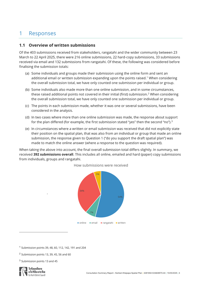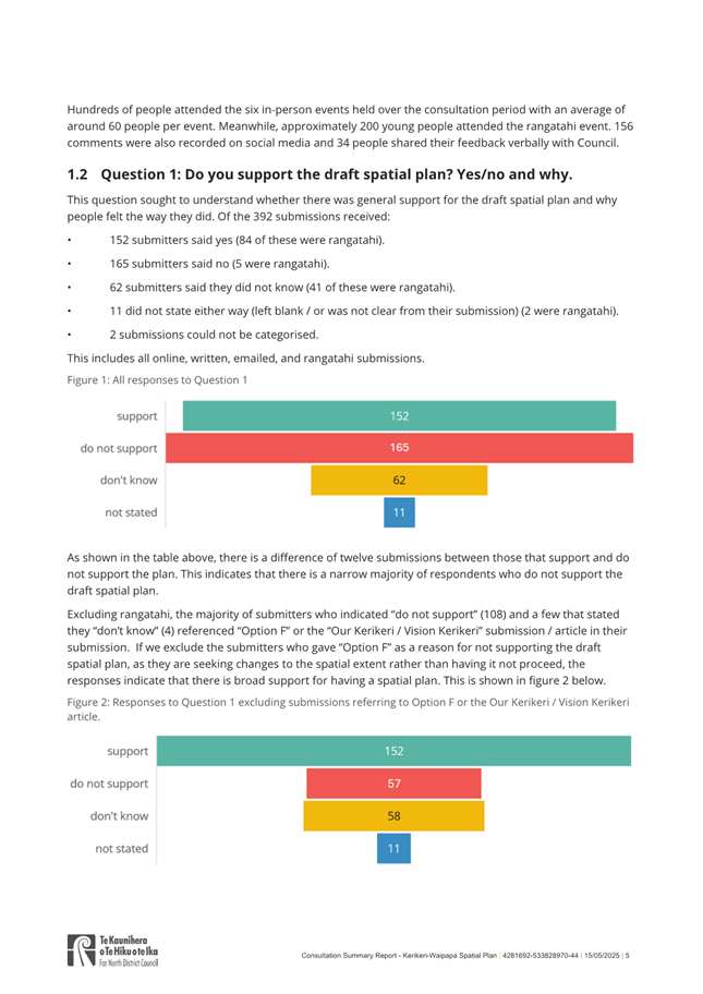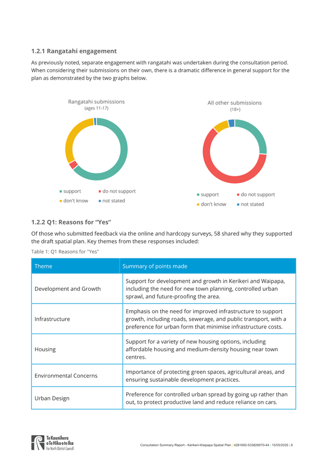


|
Extraordinary Council Meeting Agenda |
18 June 2025 |
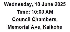
Extraordinary Council Meeting
will be held in the Council Chamber, Memorial Ave, Kaikohe on:
Wednesday 18 June 2025 at 10:00 AM
Te Paeroa Mahi / Order of Business
1 Karakia Timatanga / Opening Prayer
2 Ngā Whakapāha Me Ngā Pānga Mema / Apologies and Declarations of Interest
3 Ngā Tono Kōrero / Deputations
4 Ngā Kōrero A Te Kahika / Mayoral Announcements
5.1 Adoption of Te Pātukurea Kerikeri Waipapa Spatial Plan
6 Te Wāhanga Tūmataiti / Public Excluded
6.1 Delivery of Transport Services
7 Karakia Whakamutunga / Closing Prayer
8 Te Kapinga Hui / Meeting Close
1 Karakia Timatanga / Opening Prayer
Ka tuku mātou kia kaha mai ngā māngai kua whiriwhirihia mō Te Kaunihera o Te Hiku o te Ika ki te mahi me te ngākau auaha me te whakamahi i ngā pūkenga me te mātauranga i roto i ngā wānanga me ngā whakataunga kia whakatūria ai tētahi Hapori e matatika ana, e tū kotahi ana ka mutu ka whakapiki anō i te oranga o tō tātou rohe, ka whakatau anō i ngā take o te rohe i runga i te tika me te pono.
We ask that through Council discussions and decisions the representatives we have elected may govern the Far North District with imagination, skill and wisdom to achieve a fairer and more united Community that enhances the wellbeing of our district and solves the District’s problems efficiently and effectively.
2 Ngā Whakapāha Me Ngā Pānga Mema / Apologies and Declarations of Interest
Members need to stand aside from decision-making when a conflict arises between their role as a Member of the Council and any private or other external interest they might have. This note is provided as a reminder to Members to review the matters on the agenda and assess and identify where they may have a pecuniary or other conflict of interest, or where there may be a perception of a conflict of interest.
If a Member feels they do have a conflict of interest, they should publicly declare that at the start of the meeting or of the relevant item of business and refrain from participating in the discussion or voting on that item. If a Member thinks they may have a conflict of interest, they can seek advice from the Chief Executive Officer or the Manager - Democracy Services (preferably before the meeting).
It is noted that while members can seek advice the final decision as to whether a conflict exists rests with the member.
Elected Member - Register of Interests
3 Ngā Tono Kōrero / Deputations
No requests for deputations were received at the time of the Agenda going to print.
4 Ngā Kōrero A Te Kahika / Mayoral Announcements
|
18 June 2025 |
5.1 Adoption of Te Pātukurea Kerikeri Waipapa Spatial Plan
File Number: A5181101
Author: Jaye Michalick, Team Leader – Growth Planning & Placemaking
Authoriser: Roger Ackers, Group Manager - Planning & Policy
Take Pūrongo / Purpose of the Report
To seek approval for the adoption of Te Pātukurea – Kerikeri Waipapa Spatial Plan
The report sets out four options. A list of advantages and disadvantages in relation to each option is provided.
WhakarĀpopoto matua / Executive Summary
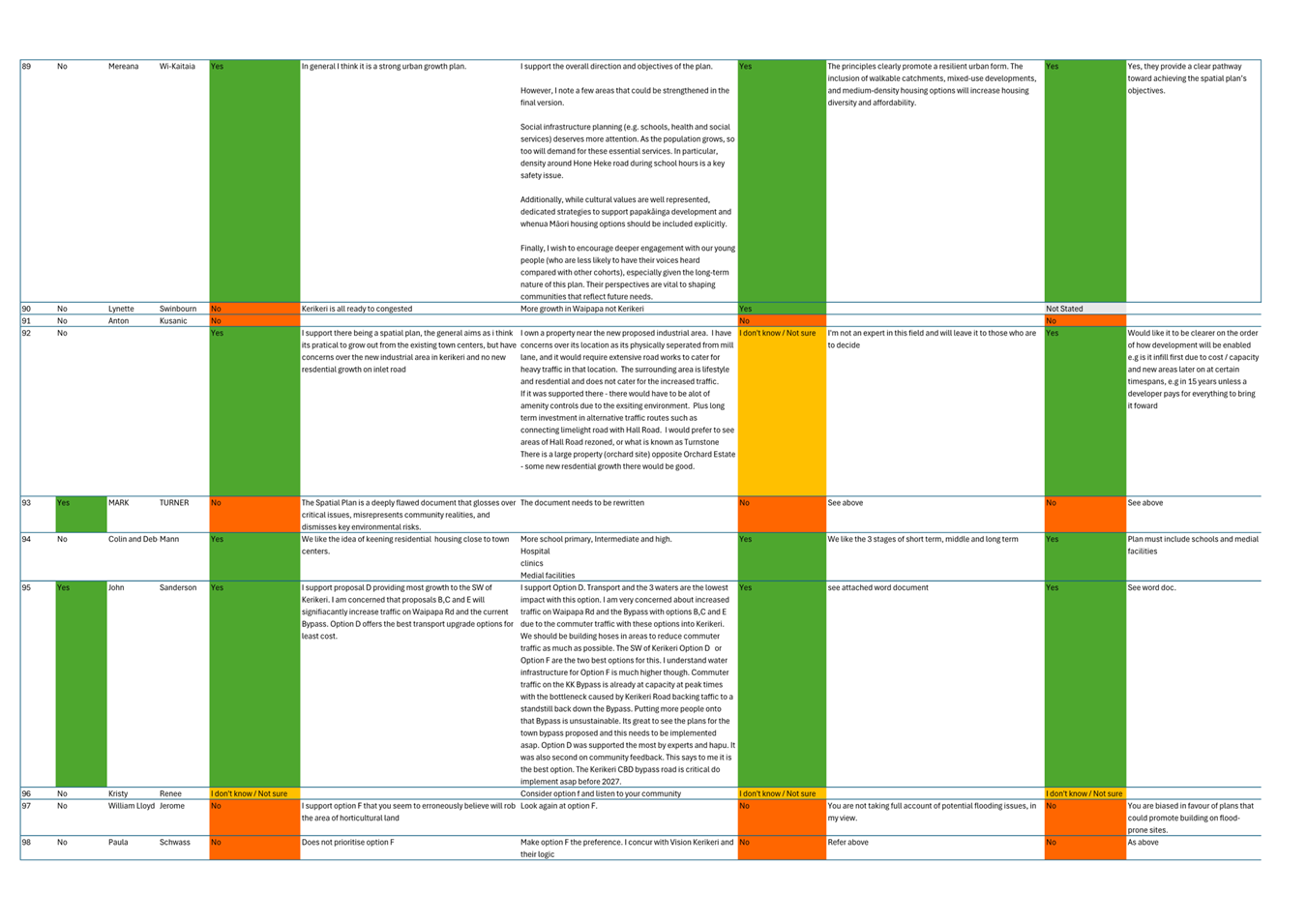
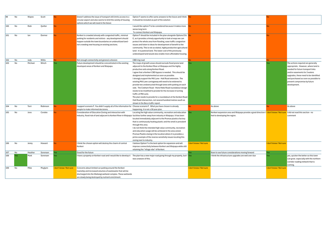
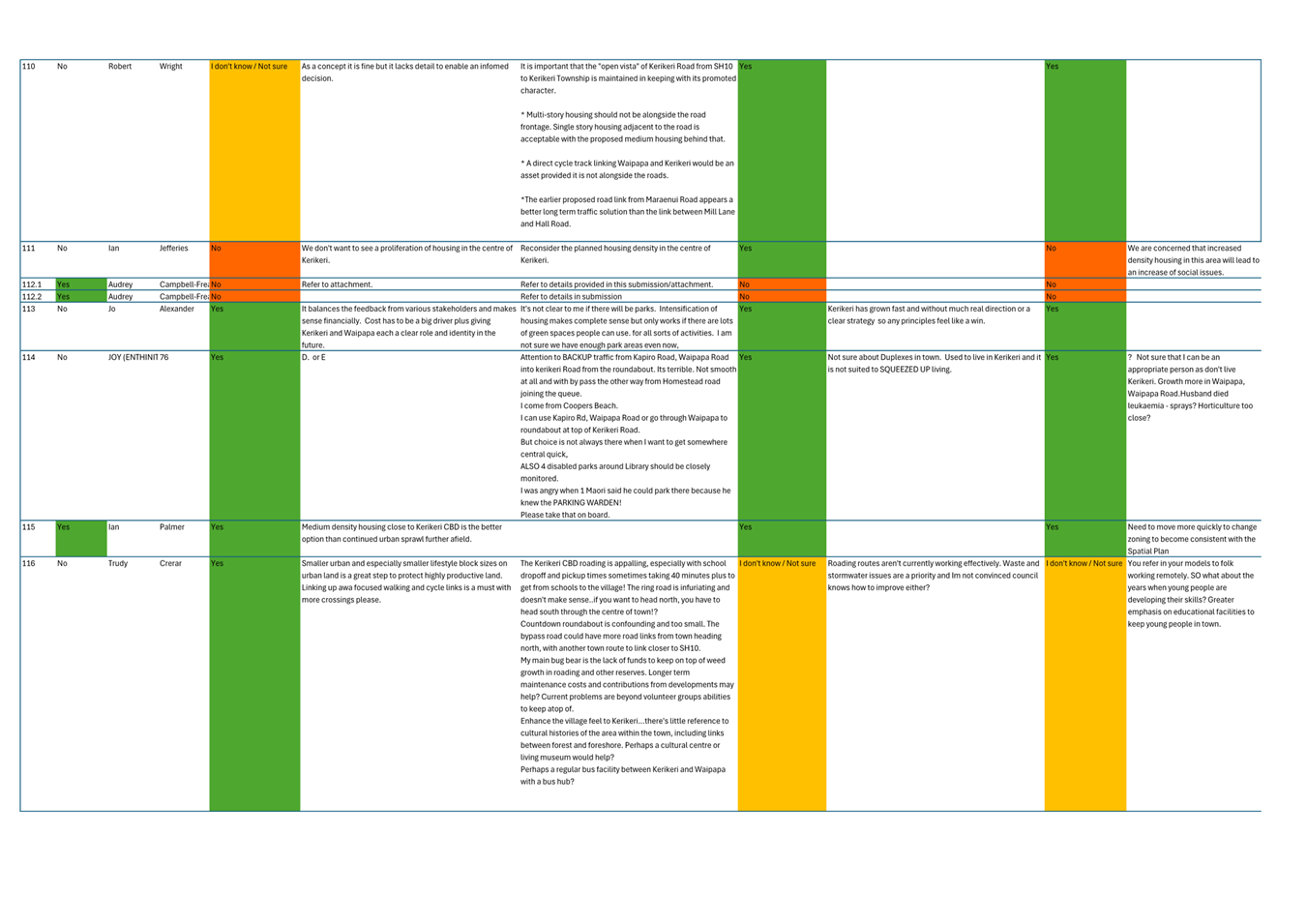
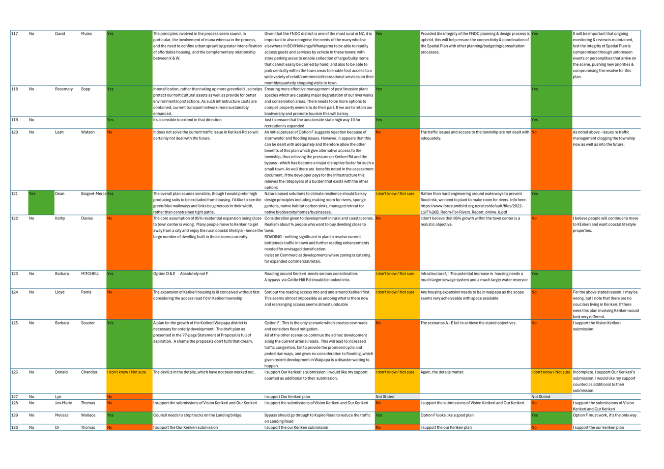
· Kerikeri, Waipapa, and surrounding areas are the fastest-growing parts of the Far North. In the absence of a long-term planning framework, this rapid growth has resulted in fragmented development, inefficient infrastructure, and limited housing choice and affordability. These issues are projected to grow in the coming years in the absence of any clear interventions.
· As a result, Council directed staff to undertake a review of the 2007 Kerikeri Waipapa Structure Plan in August 2021.
· Over the course of 2022 and through to 2025 Council worked with an established Hapū Rōpū to develop a vision for Kerikeri and Waipapa to be captured in Te Pātukurea – A spatial plan for Kerikeri Waipapa.
· A clear set of objectives and principles based on input from the Hapū Rōpū and from early public engagement were developed. Areas that could be further developed, areas that should be considered carefully before being promoted for future development, and areas unsuitable due to constraints were identified in this phase of the project.
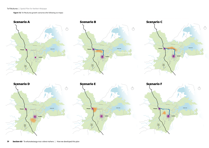
· Six growth scenarios based on blue sky growth projections were taken out for public consultation in 2024. This included Growth Scenario F.
· Analysis provided by subject matter experts in infrastructure planning, cost estimating, urban economics, spatial planning and urban design alongside a complete analysis of submissions from the public culminated in the development of a draft spatial that had the full support of the Hapū Rōpū.
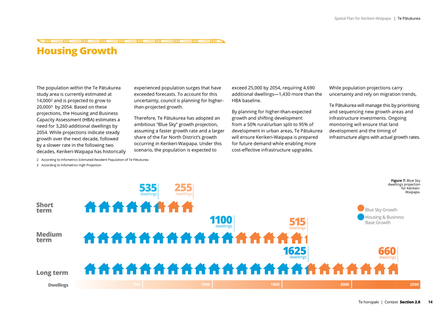
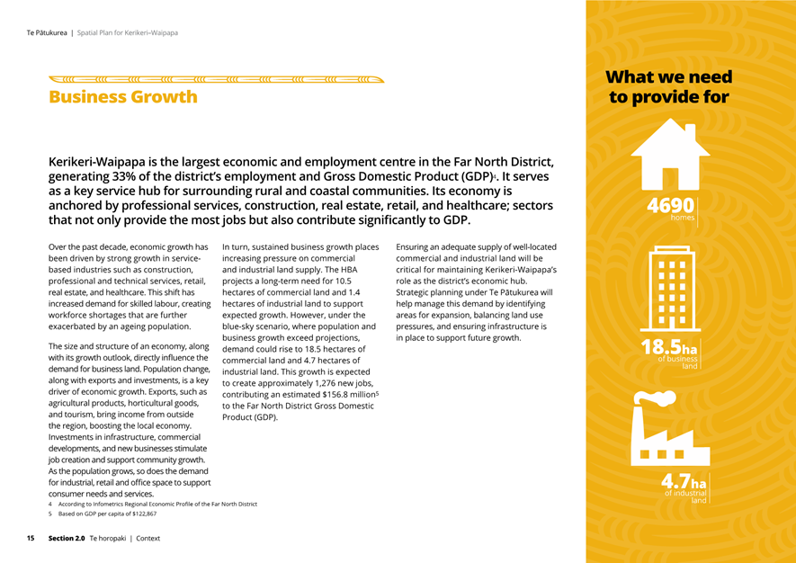
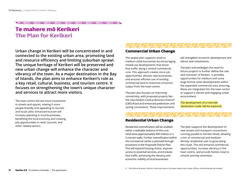
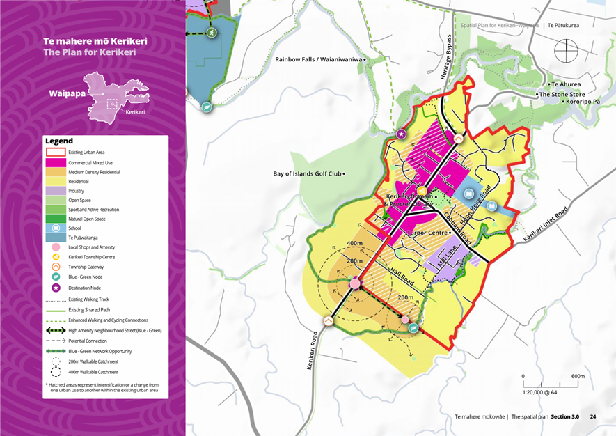
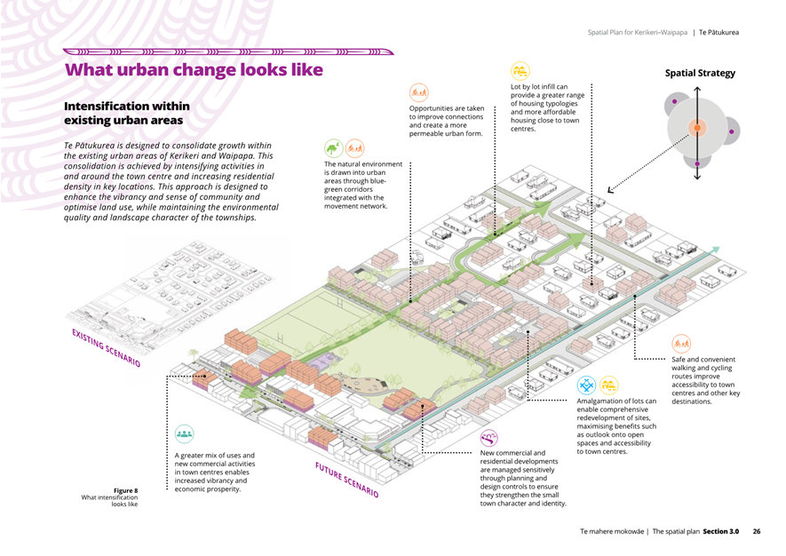
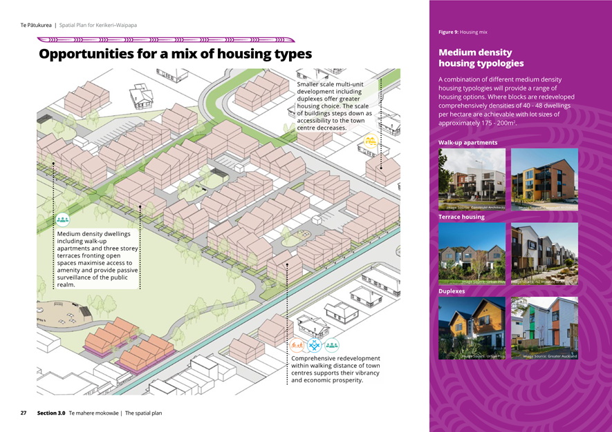
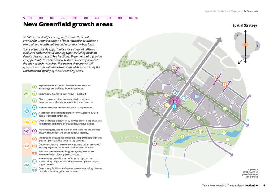
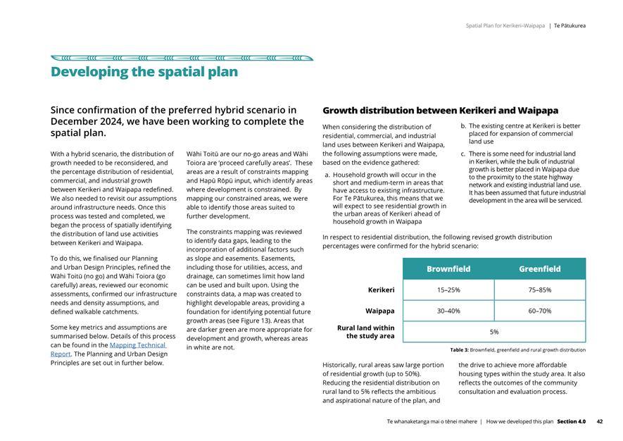
· The draft spatial plan promotes compact urban form in, and adjacent, to Waipapa and Kerikeri that is designed to cater for the additional 4,600 households required in Kerikeri, Waipapa surrounds to meet the blue sky population projections.
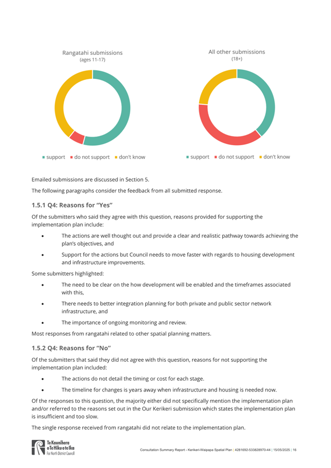
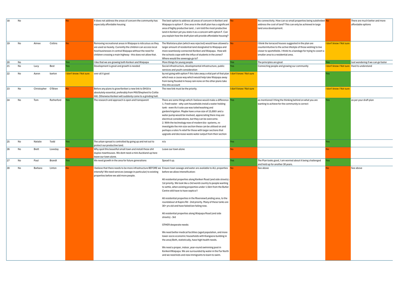
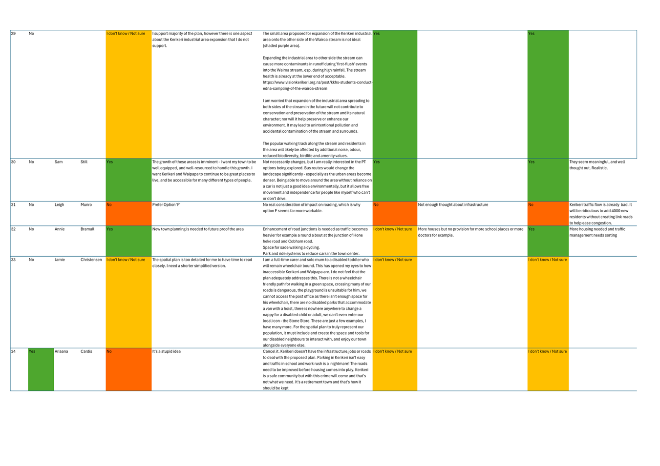
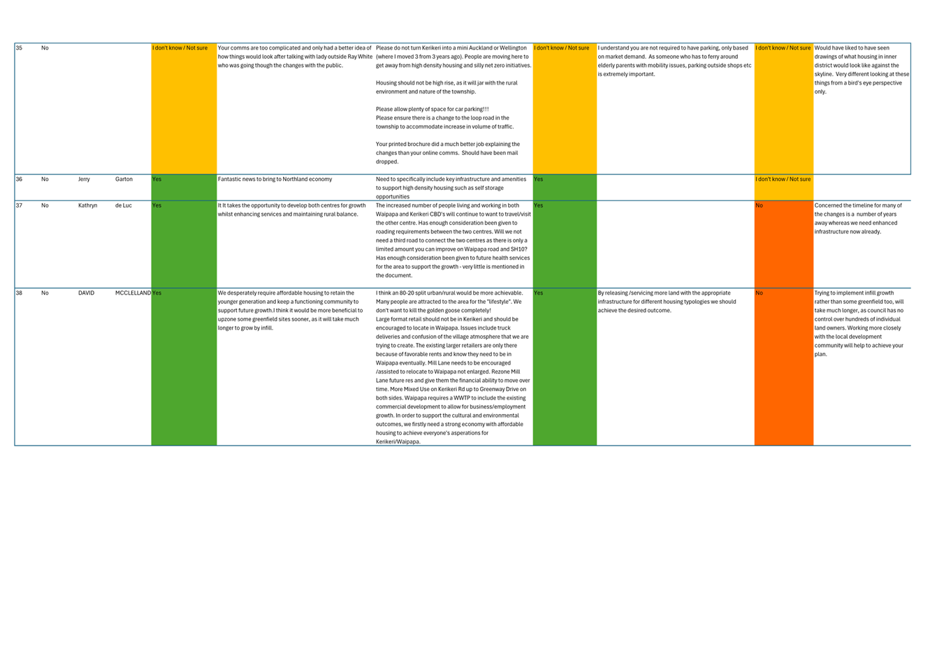
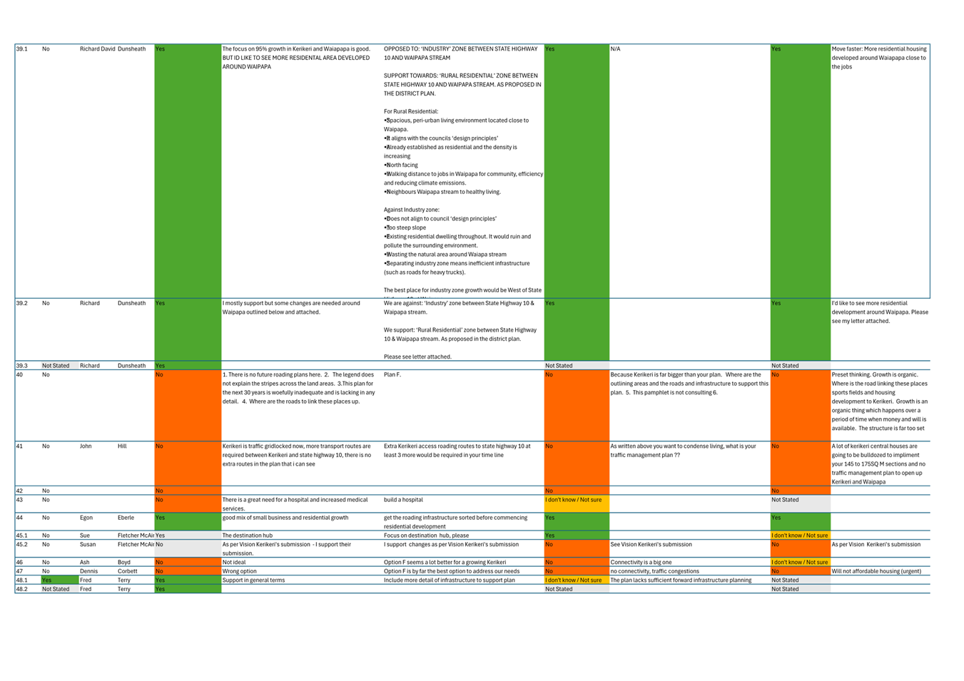
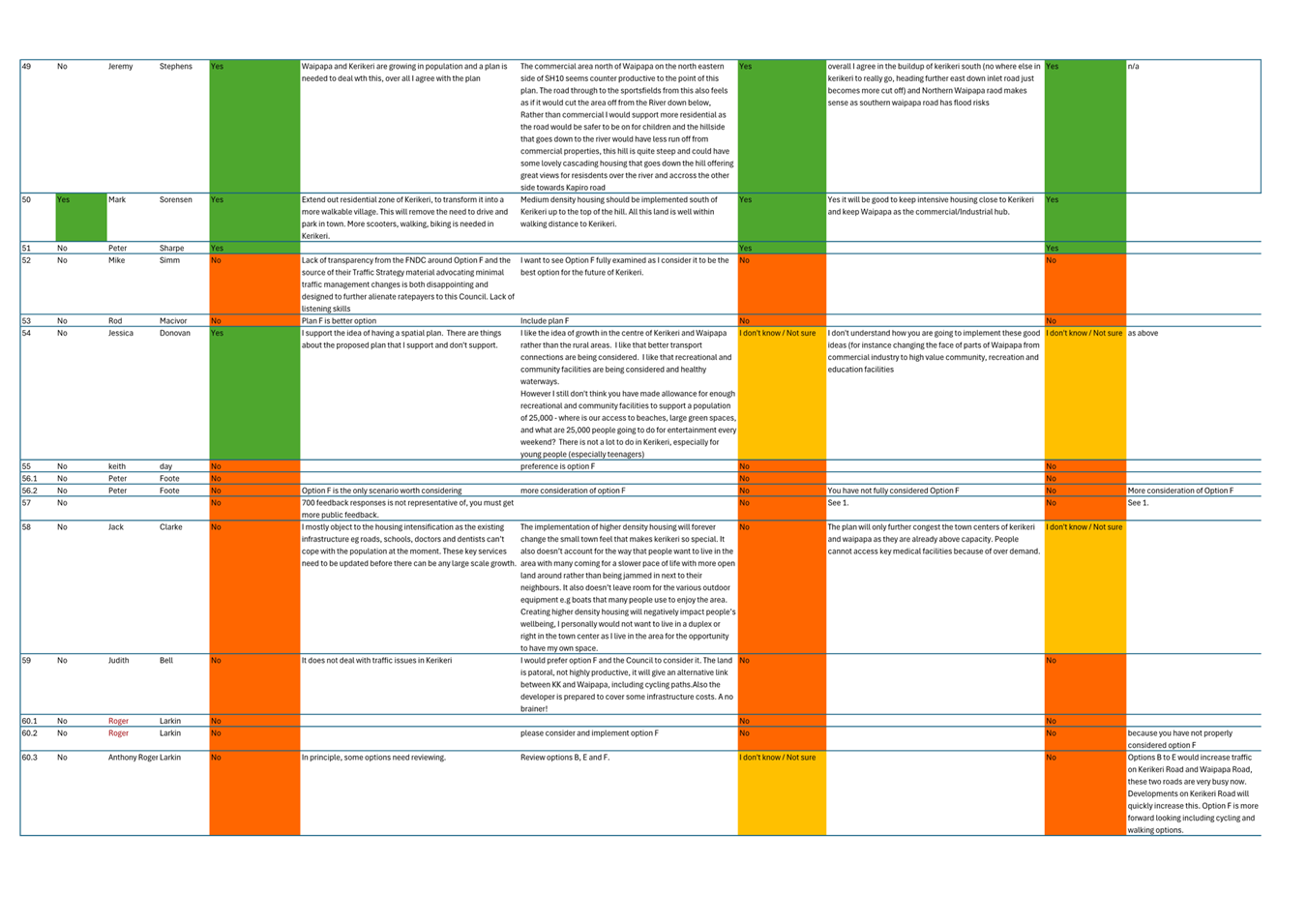
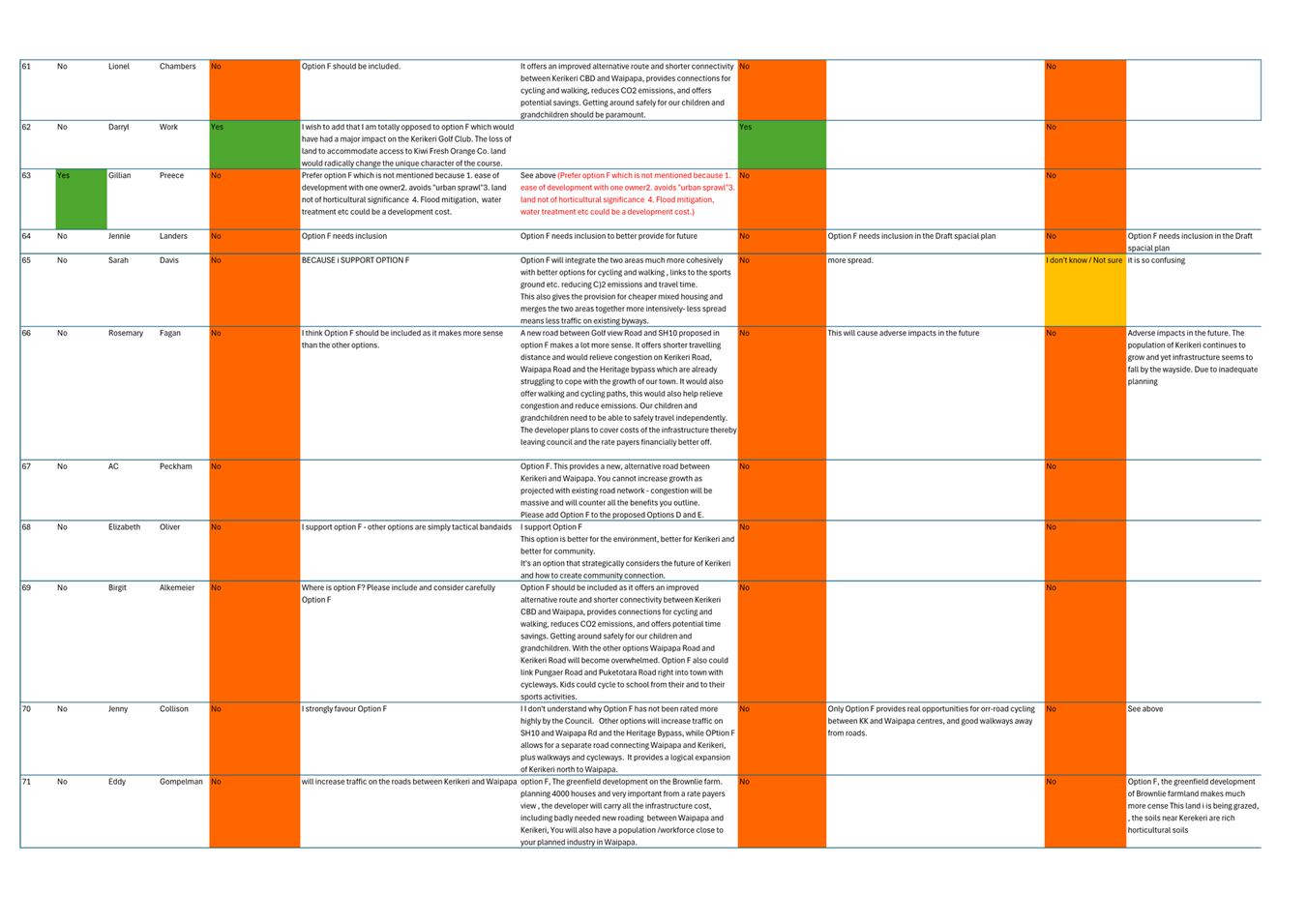
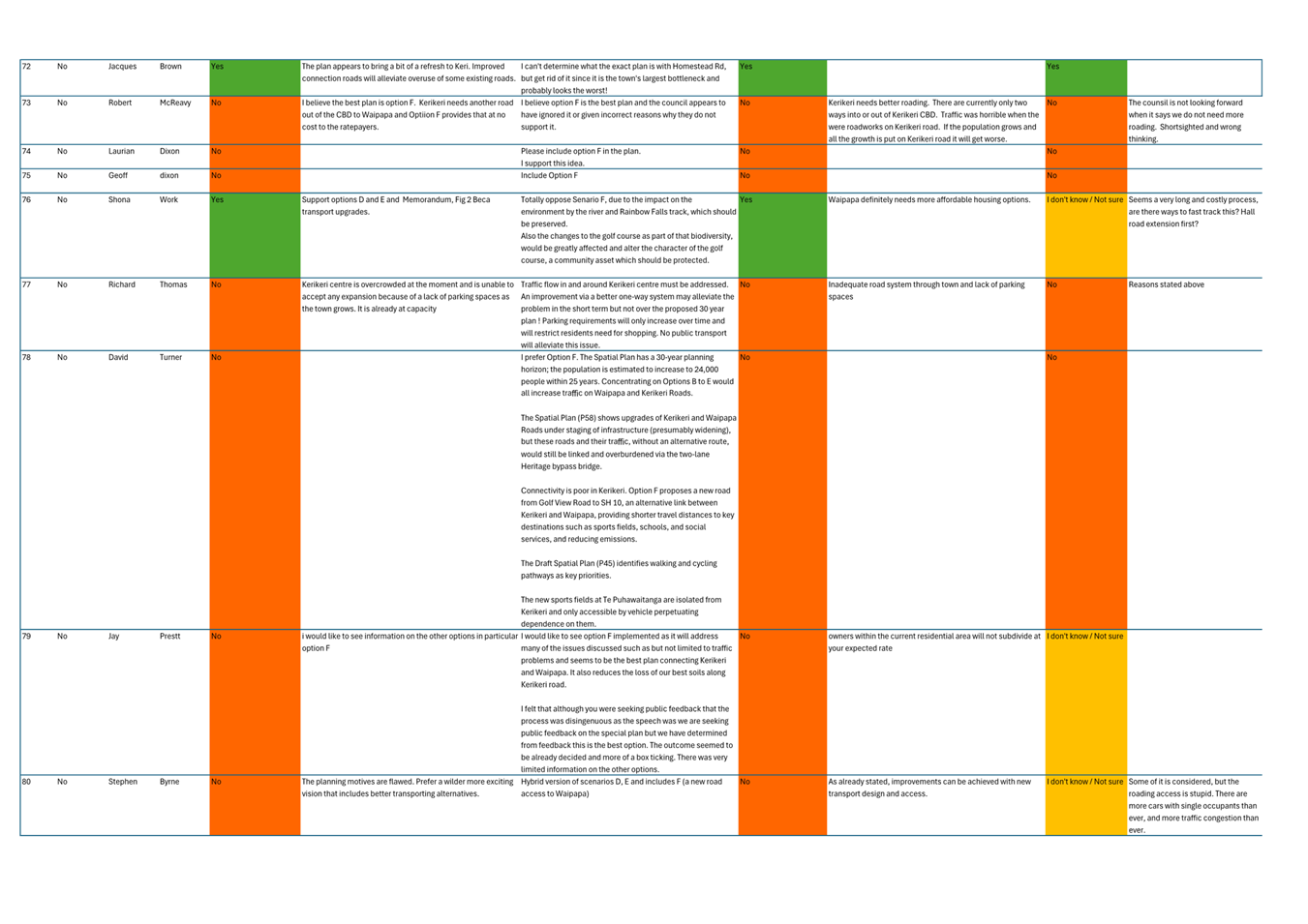
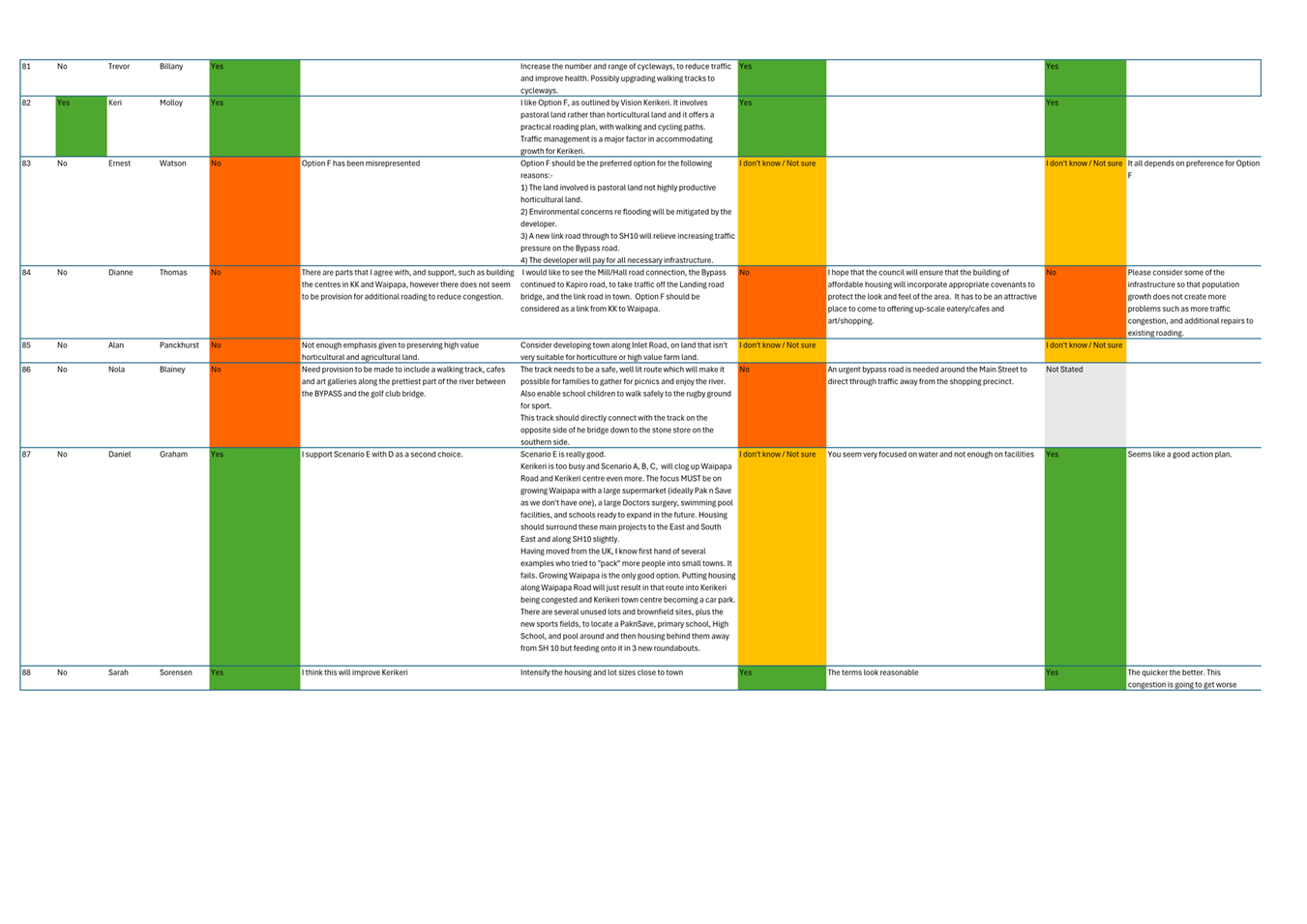
· Public consultation on the draft spatial plan resulted in 39% of submissions in support of the draft, 42% of submissions opposed to the draft and 16% of submissions unsure whether to support or oppose the draft. Of the 42% opposed to the draft spatial plan 28% stated their opposition due to the exclusion of a previously discounted growth scenario F.
· In line with the special consultative procedure followed for public consultation on the draft, Council can adopt the spatial plan, or adopt the spatial plan with amendments, or not adopt the spatial plan.
· This report includes four options on the adoption of the spatial plan, which are:
o Option A Adopt the spatial plan with amendments as per 22 May workshop with elected members.
o Option B: Adopt the spatial plan in accordance with Option A plus a further amendment that directs additional monitoring and reviews of the spatial plan. Enabling the review of greenfield areas including previously considered growth scenarios as part of the development of the spatial plan. This enables growth scenario F to be reconsidered as part of the first and subsequent plan review processes, contingent on the issues and constraints relating to scenario F being fully addressed
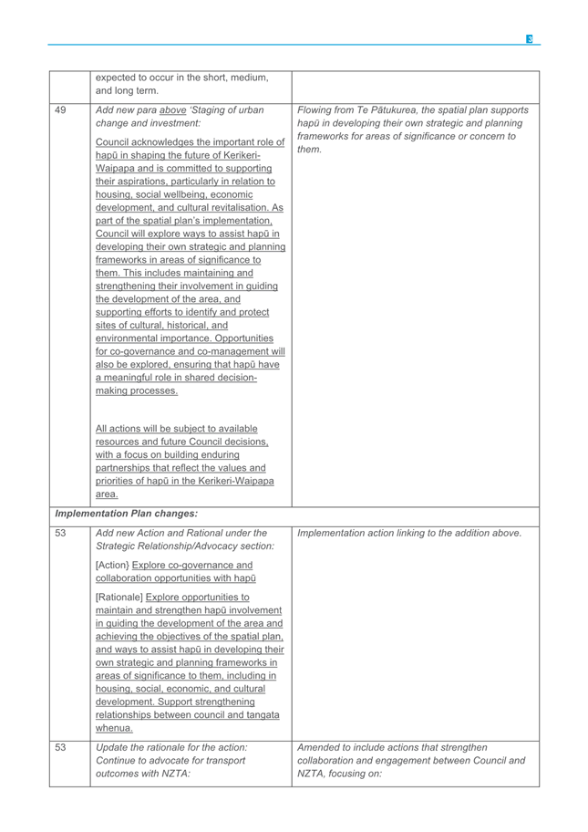
o Option C: Do not adopt the spatial plan
o Option D: Do not adopt the spatial plan and prepare a revised draft spatial plan to include scenario F. This option will also require Council to decide whether to continue or defer decision making on this project during the Pre-Election period commencing in July 2025.
· Staff recommend Option A - adoption of the spatial plan with amendments. This option results in an evidence-based spatial plan that provides clear direction for efficient long term infrastructure investment. It reflects the significant participation by the Hapū Rōpū Governance body, stakeholders, government agencies and the public through iterative rounds of engagement and consultation.
· Adoption of Te Pātukurea will result in the Far North becoming a Tier 3 council in accordance with the National Policy Statement - Urban Development 2020 (NPS-UD).
· This item was listed on the 5 June 2025 Council agenda. Due to time constraints that meeting deferred it to the 18 June extraordinary meeting.
|
That Council adopt Te Pātukurea – Kerikeri Waipapa Spatial Plan with amendments, as set out in option A of this report.
|
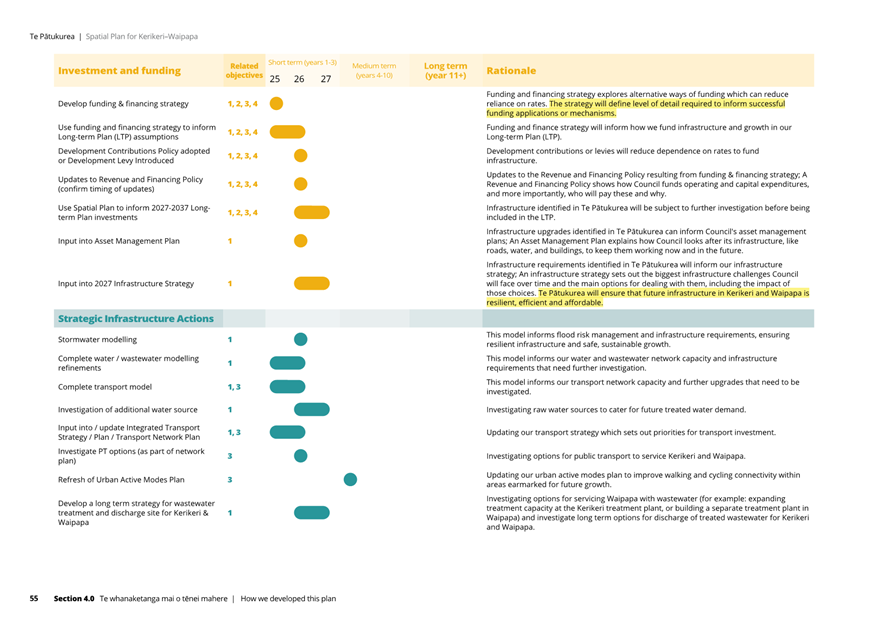
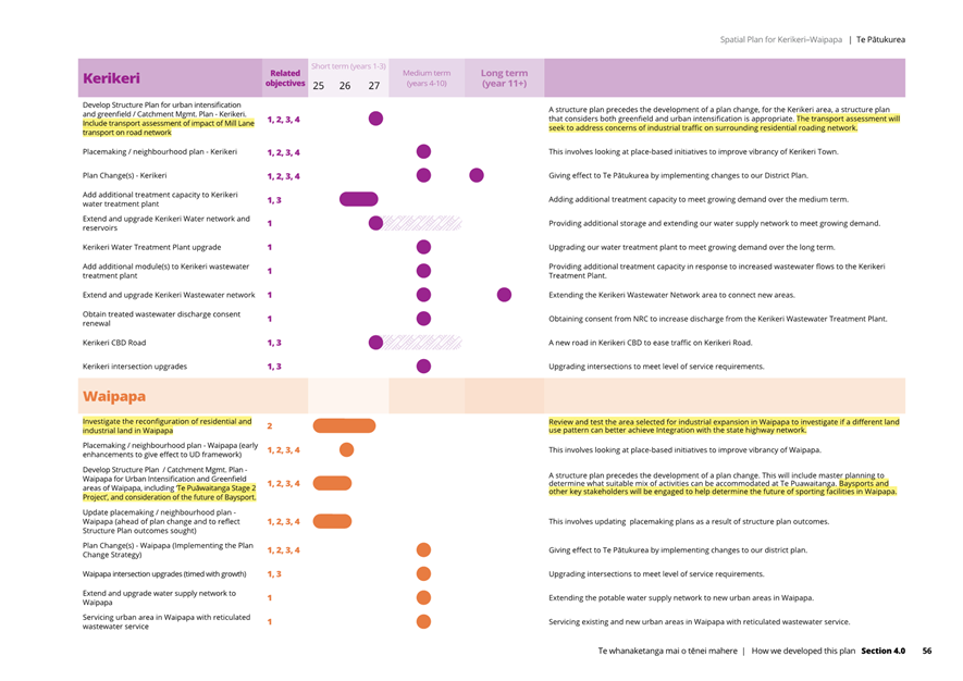
1) TĀhuhu kŌrero / Background
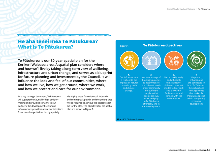
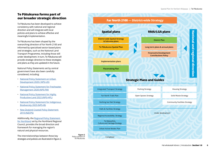
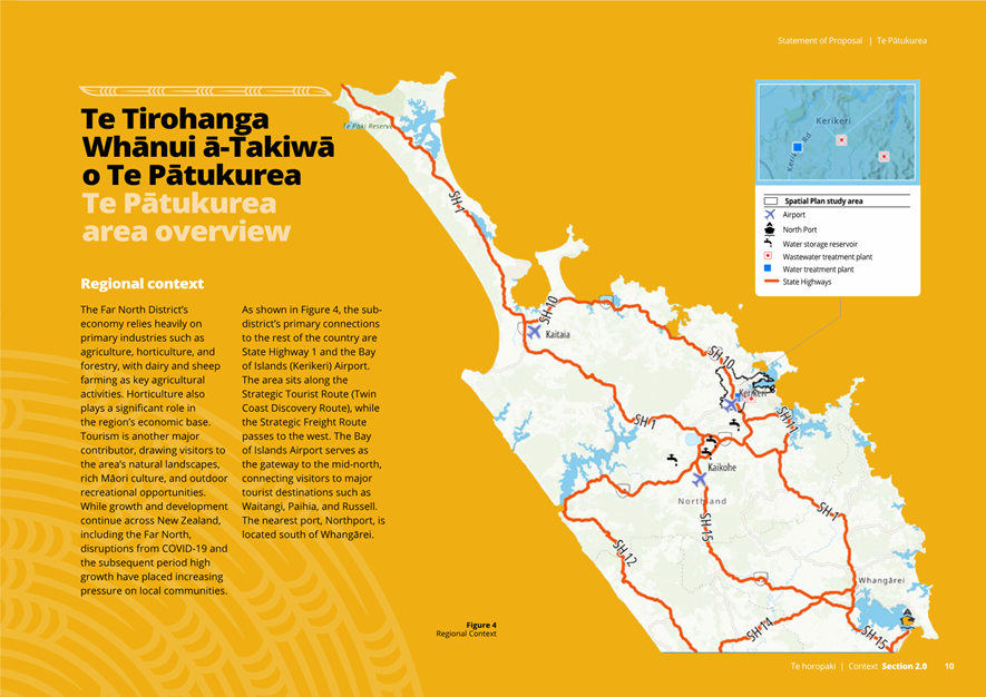
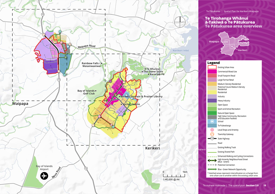
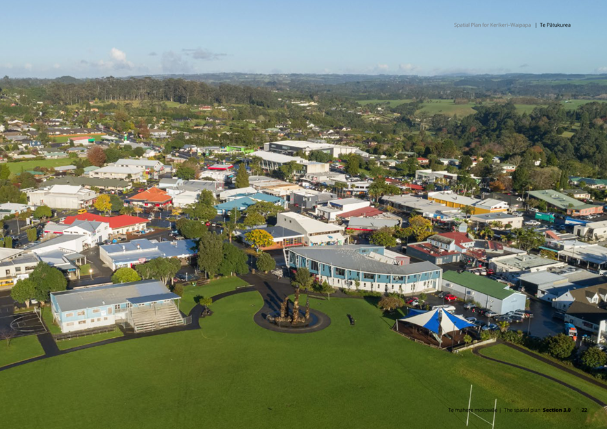
Kerikeri, Waipapa, and surrounding areas are the fastest-growing parts of the Far North. In the absence of a long-term planning framework, this rapid growth has resulted in fragmented development, inefficient infrastructure, and limited housing choice and affordability. In August 2021 Council directed staff to undertake a review of the 2007 Kerikeri Waipapa Structure Plan as the first spatial planning project undertaken as part of implementing Far North 2100.
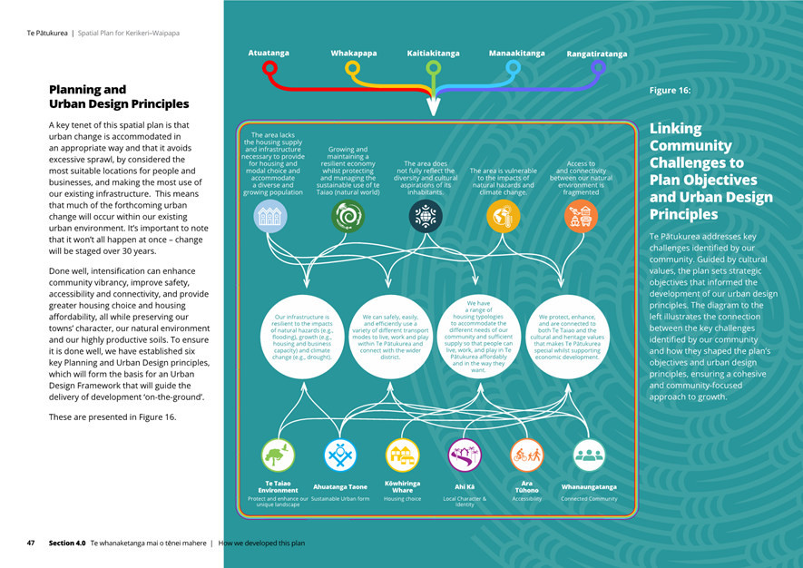
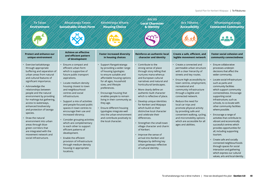
Te Pātukurea is a long-term (30 years) spatial plan that sets out a high-level framework to guide growth and urban change in Kerikeri and Waipapa. Its objectives are to achieve:
· resilient infrastructure
· a diverse and affordable housing supply
· safe, connected transport networks
· the protection and enhancement of the natural environment, culture, and heritage.
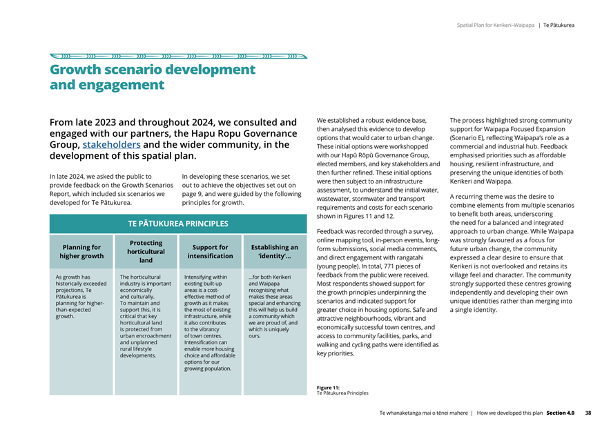
The growth principles underpinning Te Pātukurea are:
· planning for higher growth (as growth has historically exceeded expectations)
· protecting horticultural land from urban encroachment to maintain and support the horticultural industry
· support for intensification as a cost-effective method that makes the most of existing infrastructure
· establish an identity for Kerikeri and Waipapa, recognising what makes these areas special.
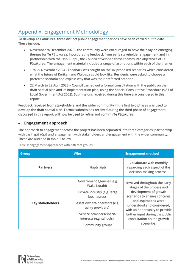
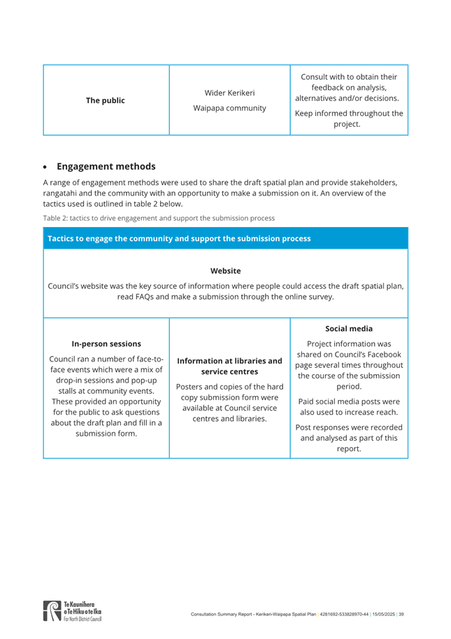
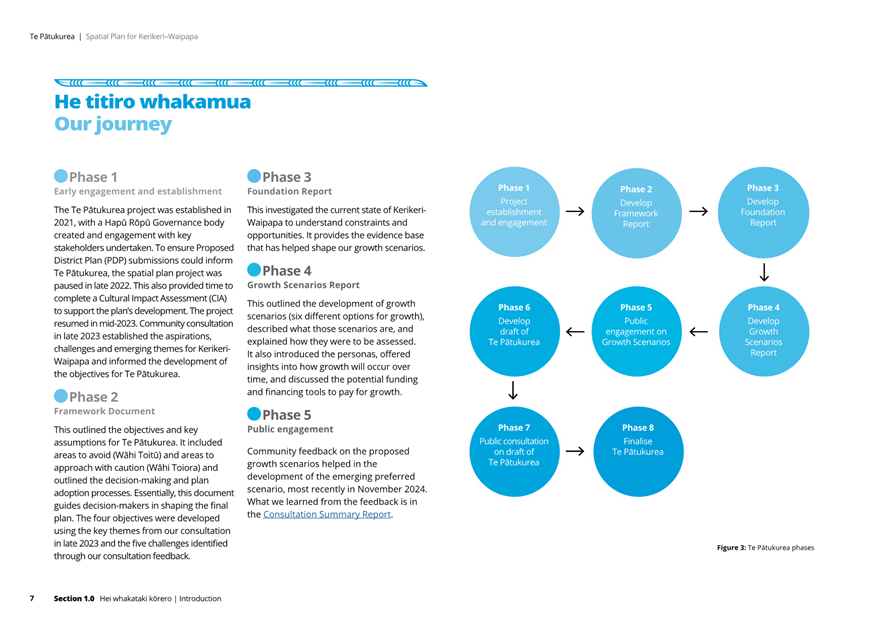
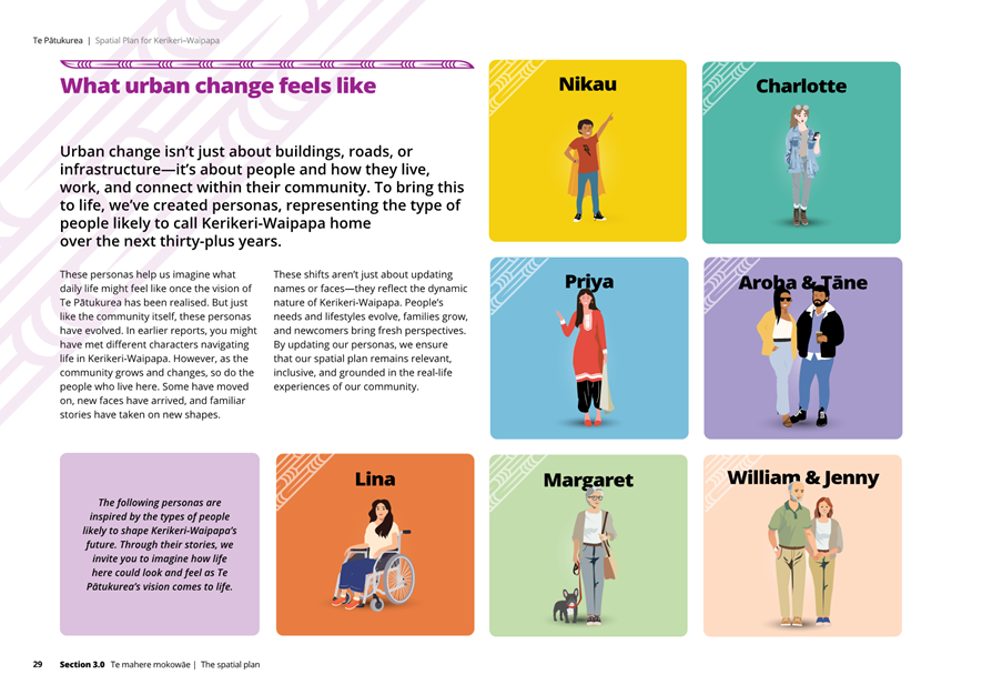
The draft plan was developed using best practice, technical expertise, and it is founded on a robust evidence base. Ongoing input from the Hapū Rōpū Governance Group, stakeholders, and the community has shaped the plan from project commencement (late 2021). As partners, the Hapū Rōpū have contributed since the project’s inception, and engagement with stakeholders and the public has occurred throughout.
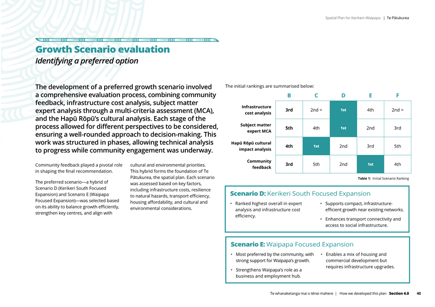
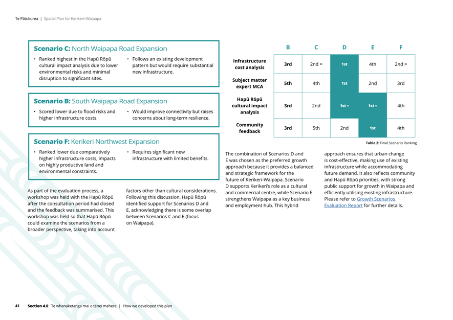
Formal public consultations took place in late 2023 to shape the plan’s objectives and growth principles, again in 2024 to test six potential growth scenarios including growth scenario F, and finally in early 2025 to consult on the draft spatial plan. Following consultation in 2024, the six growth scenarios were evaluated using four methods to rank or assess the scenarios, they were:
· ranked highest to lowest in terms of infrastructure costs (required to service growth in each scenario). Scenario D (Kerikeri South Expansion) ranked highest in terms of this efficiency.
· assessed in terms of cultural impact. Scenario C (North Waipapa Road Expansion) scored highest by our Hapū Rōpū Governance Group for due to lower environmental risks and minimal disruption to significant sites
· ranked by subject matter expert (SME) analysis. Scenario D was ranked highest overall by our various SME’s
· ranked in terms of public preference. Scenario E (Waipapa Expansion) was most preferred by the community as part of the engagement on the six scenarios, engagement that included Scenario F.
A hybrid growth scenario comprising parts of Scenarios D, E and C was agreed by the Hapū Rōpū and Council as the preferred growth scenario, which was then incorporated into the draft spatial plan that was taken out for public consultation.
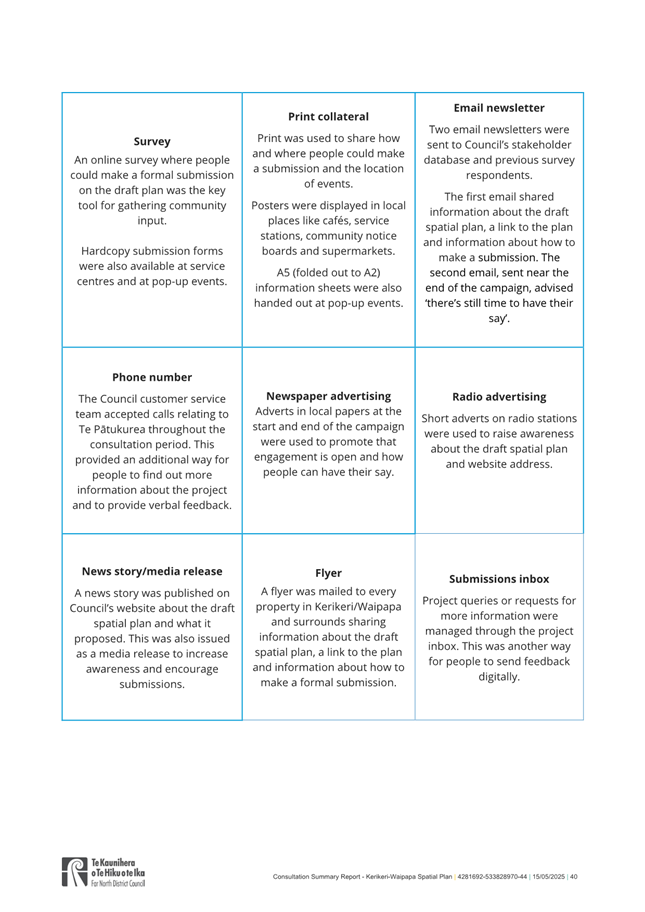
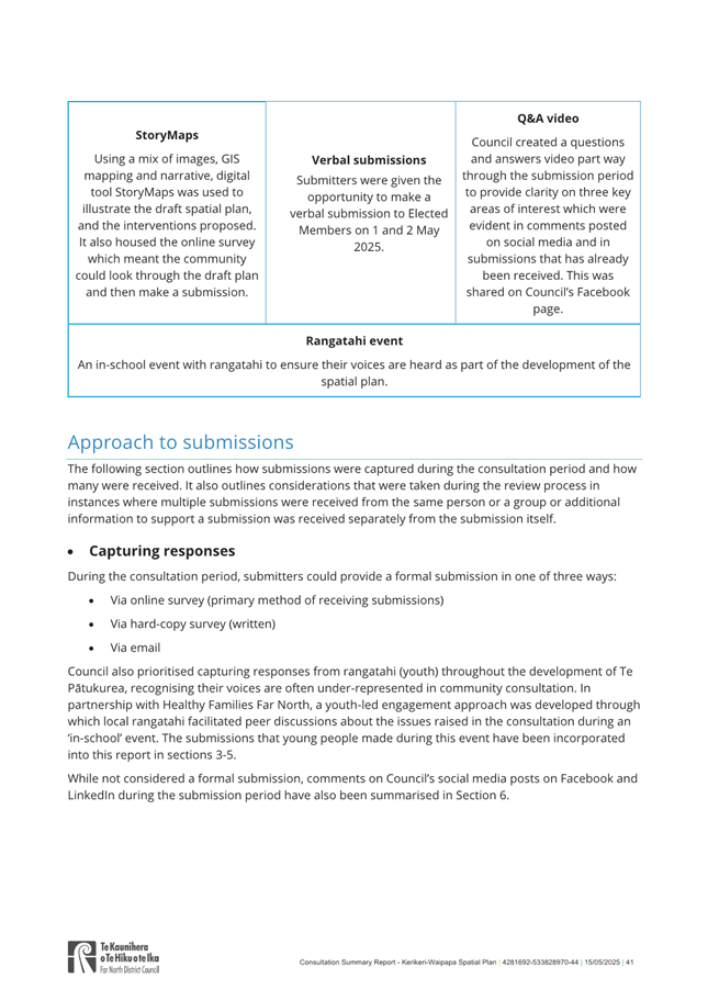
Public consultation on proposed spatial plan, March-April 2025.
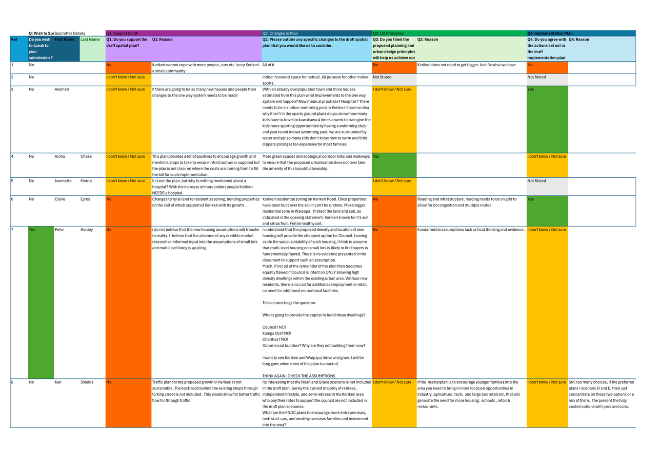
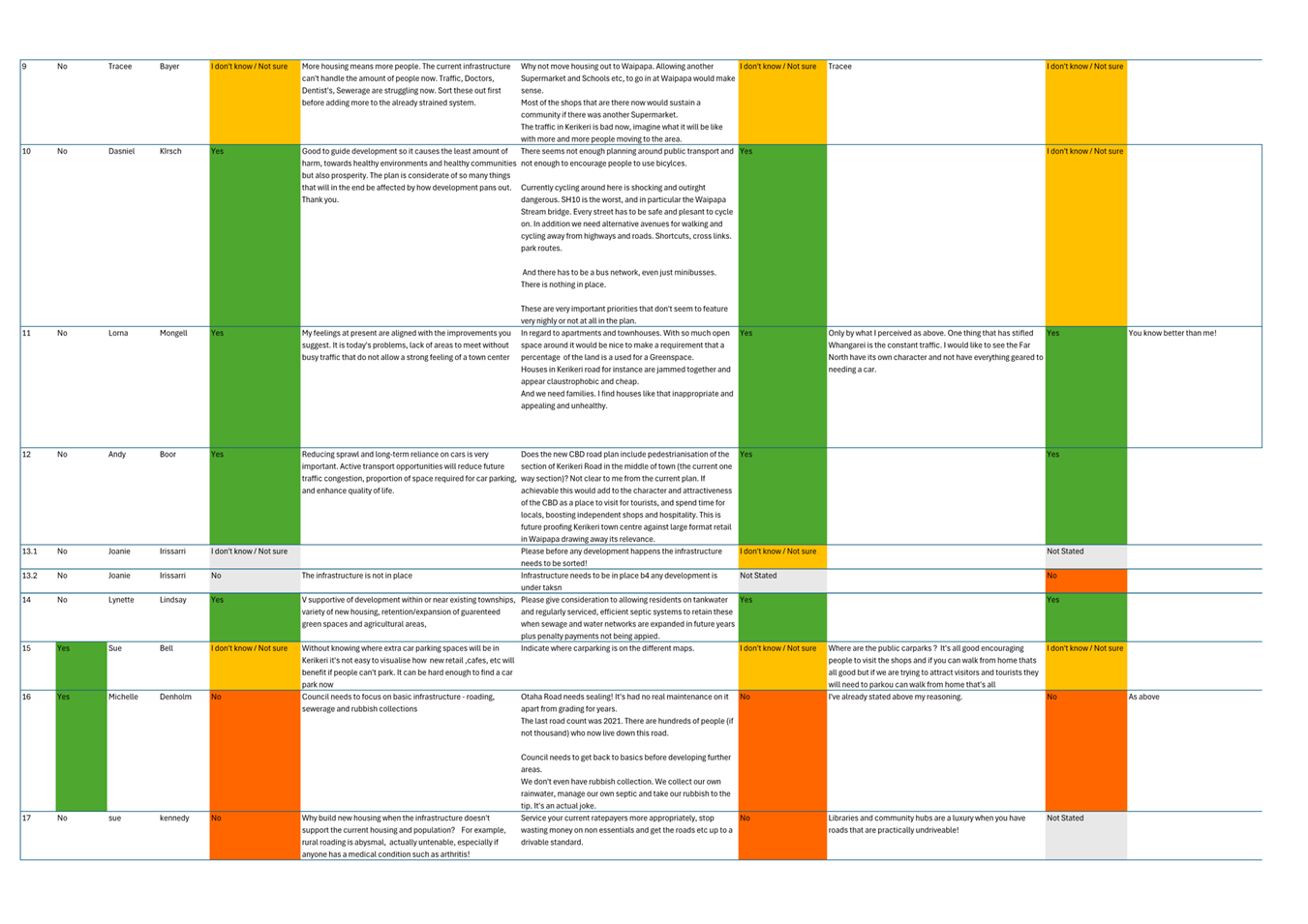
The most recent consultation (March–April 2025) focused on the draft spatial plan, presented through the Council’s Statement of Proposal. A comprehensive summary of public feedback is included in Attachment 1 Consultation Summary Report and Attachment 2 the resulting Deliberations Report.
This consultation asked three specific questions, these were:
· Do you support the draft spatial plan?
· Do you think the proposed planning and design principles will help us achieve our plan objectives?
· Do you agree with the actions set out in the implementation plan?
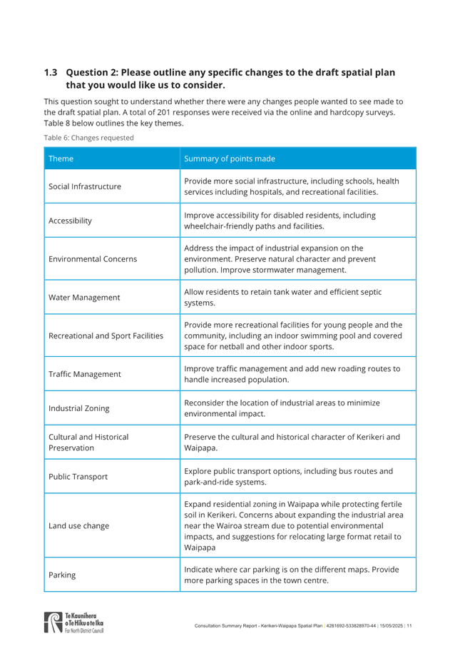
Submitters were also given the opportunity to outline specific changes to the draft spatial plan.
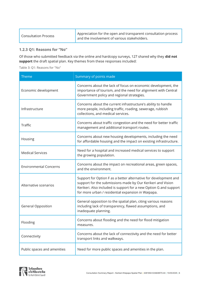
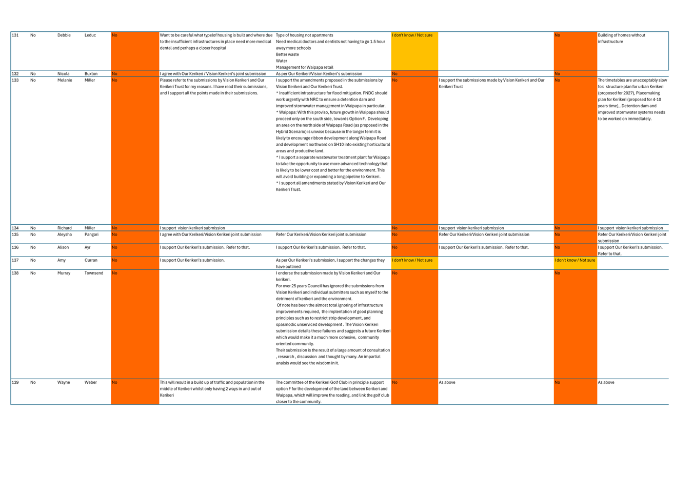
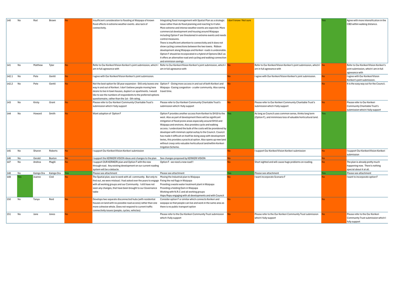
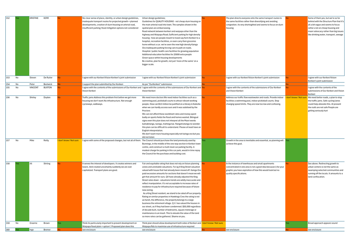
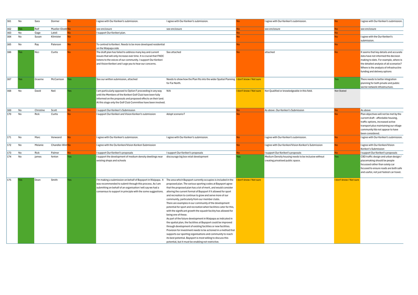
Overall, 152 (39%) submitters supported the draft spatial plan, and 165 (42%) did not support it.
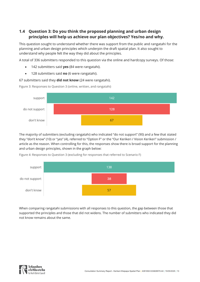
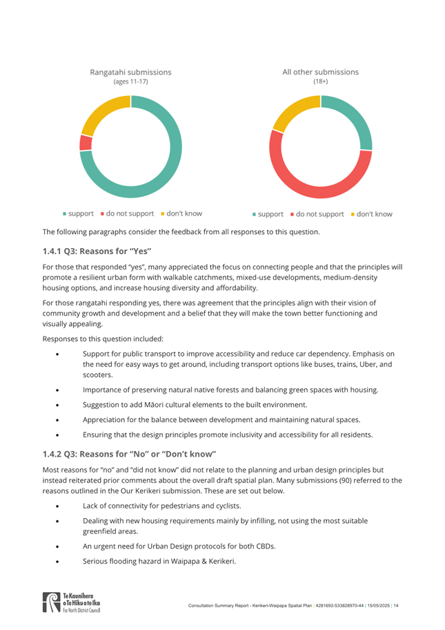
142 (42%) submitters supported the plan’s planning and urban design principles, and 128 (38%) did not support them.
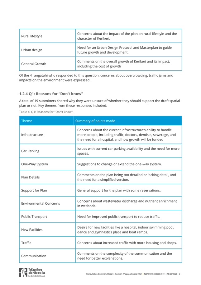
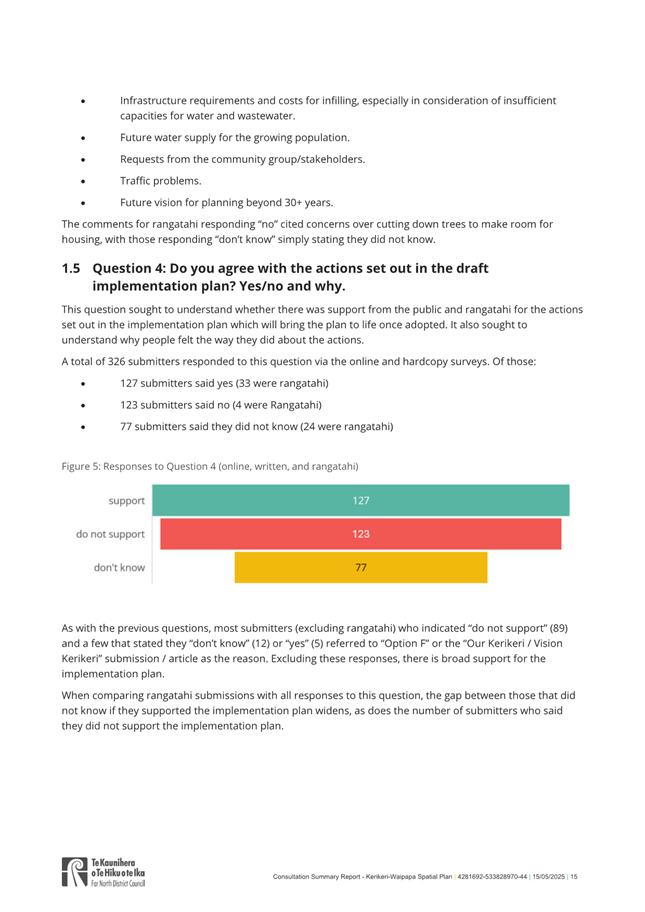
127 (39%) agreed with the actions set out in the implementation plan, and 123 (38%) did not agree with these actions.[1]
Of the 42% in opposition to the draft spatial plan:
· 14% of submitters opposed the draft plan due to various concerns including inadequate infrastructure, poor transport links, and impacts on Kerikeri’s character
· 28% of submitters opposed the plan because it excludes scenario F, which had been previously assessed and discounted in an earlier stage of the draft plan development, which considered community feedback via public consultation on the 6 proposed growth scenarios. Many of these submitters noted critical success factors that would first need to be addressed for scenario F to be a viable alternative. These factors included;
· funding and installing flood mitigation
· a comprehensive cost benefit analysis
· developer accountability for affordable housing outcomes, green spaces, walkability and community infrastructure and
· development contributions tied to infrastructure and amenity outcomes.
Broadly, those who submitted in opposition to the plan due to scenario F’s exclusion also indicated support-in-principle for a spatial plan for Kerikeri-Waipapa and did not request to reduce the proposed hybrid greenfield area.
The Statement of Proposal outlined three potential outcomes:
A. Adopt the spatial plan
B. Adopt the spatial plan with amendments
C. The Council maintain the status quo and does not adopt the spatial plan.
Adoption of Te Pātukurea confirms that the growth being planned for Kerikeri-Waipapa is of a scale that meets the definition of an urban environment under the NPS-UD, which results in the Far North becoming a Tier 3 council. Urban environments are predominantly urban in character with a housing and labour market of at least 10,000 people. Tier 3 council’s are required to ensure sufficient housing and business land development capacity in its district over the short, medium and long term. The development capacity must be plan-enabled, infrastructure ready and feasible and reasonably expected to be realised. Tier 3 status requires council’s to monitor and review data relating to demand and supply of dwellings. Lastly, Tier 3 status requires removal of any ‘minimum carparking’ requirements in our Far North District Plan.
The following section outlines the options available to Council and the key advantages and disadvantages of each.
2) matapaki me NgĀ KŌwhiringa / Discussion and Options
Option A: Adopt the spatial plan with amendments
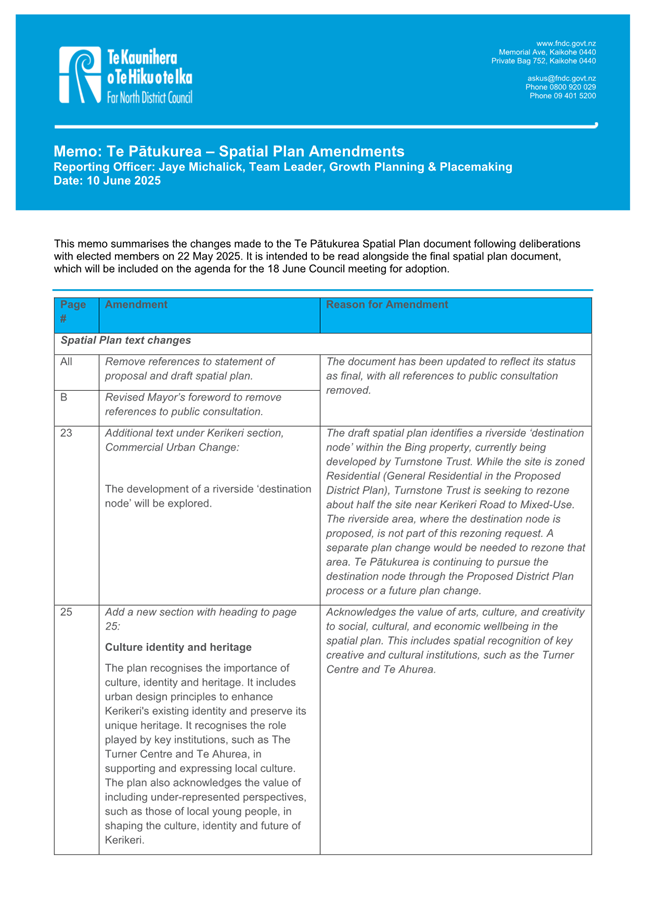
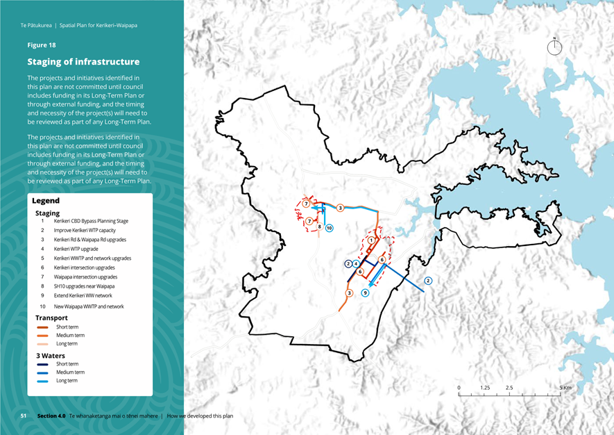
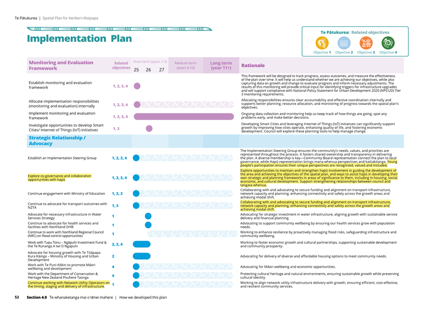
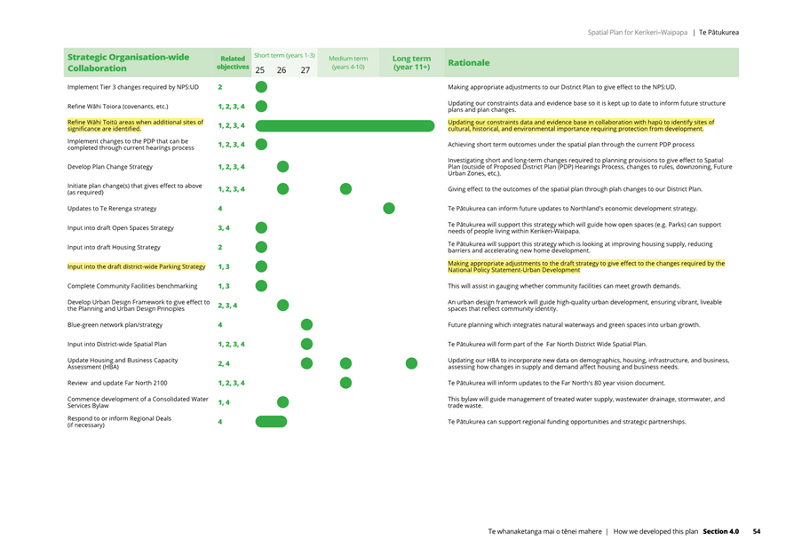
Under this option, Council adopts the amended spatial plan, including staff recommendations and elected member responses as workshopped on 22 May 2025 (refer Attachment 3 Memo on Spatial Plan Amendments and Attachment 4 – The Spatial Plan, showing amendments highlighted yellow).
Adopting the plan—Te Pātukurea—completes a major long-term planning initiative. It provides a clear, evidence-based ‘blueprint’ for efficient, resilient urban development that reflects community aspirations, and it aligns with best-practice planning principles.
While the plan offers certainty for how growth will proceed in Kerikeri and Waipapa, it remains a living document and will undergo regular monitoring, evaluation, and periodic review. It will respond to any future Council decisions where applicable, such as ensuring consistency with outcomes from the Proposed District Plan (PDP) and changes to the environment such as any future flood mitigation projects for Waipapa undertaken by Northland Regional Council (NRC).
Once adopted, Te Pātukurea will guide the PDP and any subsequent changes to the District Plan and shape Council’s Infrastructure Strategy and Long-Term Plan (10-year budget).
If this option is endorsed by Council, the yellow highlighter will be removed from the amendments within the spatial plan and the spatial plan published as final.
Advantages:
· completes a long-term, community-informed, evidenced-based planning process based on best practice
· supports compact, efficient development while protecting productive land and avoiding new areas of natural hazard risk, consistent with national direction
· provides a clear, integrated framework for urban development, informing the PDP hearings and long-term infrastructure planning
· is consistent with recommendation for adoption by the majority (6 out of 8) of the Hapū Rōpū Governance Group members
· offers certainty to the community, developers, stakeholders, and utility providers around Council’s plan for growth
· Informs and enables development contribution policy levies / fees
· enables coordinated, climate-resilient infrastructure delivery and reduces the risk of inefficient or ad hoc investment
· it is based on supporting urban growth in and around the existing towns to provide for the most cost-effective use of infrastructure
· will improve housing choice and affordability, which are identified as supply gaps for Kerikeri and Waipapa, per the Housing and Business Assessment (HBA).
Disadvantages:
· some community members may remain dissatisfied that scenario F was not included
· not supported by two hapū within the Hapū Rōpū Governance Group (Ngāti Rēhia and Ngāti Hineira).
Council currently has $129.7M allocated in its 30-year Forward Works Plan for new and upgraded water supply and wastewater infrastructure in Kerikeri and Waipapa. If Te Pātukurea is adopted by Council, the infrastructure identified as necessary to service the hybrid growth scenario (with associated cost estimates) will inform infrastructure cost estimates into the Water Services Delivery Plan as per Council’s Local Waters Done Well (LWDW) project.
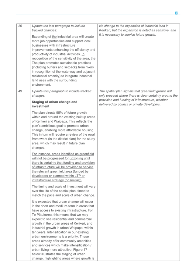
Option B: Adopt the spatial plan in accordance with Option A plus a further amendment that directs additional monitoring and reviews of the spatial plan. Enabling the review of greenfield areas including previously considered growth scenarios as part of the development of the spatial plan.
Under this option, Council adopts the amended spatial plan (refer Attachment 4), including staff recommendations and elected member suggestions per the workshop on 22 May 2025; plus one additional amendment.
The following additional amendment will be added to the spatial plan text (p. 41):
Page 41 Additional text:
Te Pātukurea is a living document subject to ongoing monitoring and scheduled review. Reviews of the spatial plan will be scheduled to occur when the Proposed District Plan becomes operative, and also no later than two years after the spatial plan is adopted. Subsequent reviews will occur per the standard review schedule. In each review, Council will reassess alternative greenfield areas for future growth where new, materially significant information demonstrates that any previous risks, constraints and costs (including funding commitments by developers to reduce costs to ratepayer) have been resolved. This includes areas that did not fully meet the objectives and principles of the spatial plan, such as scenario F which has the following risks, constraints and cost considerations:
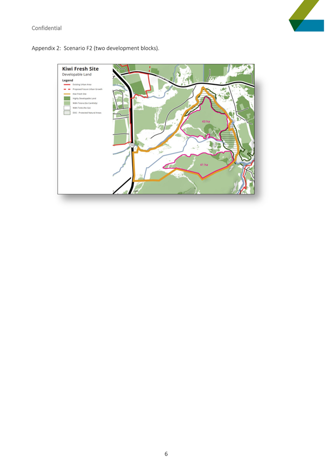
· Flood risk: About 45% of scenario F is flood prone. Urban development of the site poses significant risk to life, property and infrastructure
· Excessive development costs 205.4M to $345.8M that aren’t assessed as achieving housing choice and affordability and which the landowner has no commitment to fund
· Loss of productive land: Around 89% of scenario F is classified as highly productive land under the National Policy Statement – Highly Productive Land (NPS-HPL)
· Disconnected growth: Physical barriers—rivers, SH10, and the golf course—separate this area from existing towns, limiting integration and well-connected urban form
· Regulatory uncertainty: Approvals for flood defences, transport corridors, and land use changes are uncertain
· Inconsistent with central, regional and local policy (particularly regarding urban sprawl and development in hazard-prone areas)
· Opposition by the Bay of Islands / Kerikeri Golf Club to sell land to enable the transport connections between the site and existing urban area of Kerikeri.
Any change to the greenfield areas must remain consistent with the objectives and growth principles (as outlined in the background section of this report) of Te Pātukurea, and demonstrate it provides for best practice in planning and urban design, and is evidence based.
This will ensure a consistent approach is taken with any changes to the adopted spatial plan.
Each periodic review may result in:
· a recommendation to Council to re-consult on aspects of long-term greenfield growth, or
· a report to Council advising that no changes to the plan are required.
A consequential amendment to Monitoring and Evaluation Framework section of the Implementation Plan is also required.
Implementation Plan Monitoring and Evaluation Framework action amendment:
Add Spatial plan reviews will be scheduled to occur when the Proposed District Plan becomes operative, and also no later than two years after the spatial plan is adopted. Subsequent reviews will occur per the standard review schedule. These reviews will include determining whether new and materially significant information demonstrates a need to reassess alternative greenfield areas.
These additional amendments acknowledge the sentiment towards alternative growth scenarios among some in the community and explicitly provides a mechanism for re-assessing greenfield component of the spatial plan, including options previously deemed unsuitable.
Advantages
· completes a long-term, evidence-based planning process shaped by community input and best practice
· preserves a predictable, transparent process for future reviews of the spatial plan, maintaining public confidence and the integrity of the plan’s objectives
· supports compact, efficient growth in the short-term while avoiding hazards for new development areas and protecting productive land—aligned with national policy
· provides a clear, integrated framework for urban development in the short term, and guides the PDP hearings and infrastructure planning
· offers certainty for the community, developers, stakeholders, and service providers in the short term
· enables coordinated, climate-resilient infrastructure investment and reduces the risk of inefficient or ad hoc spending in the short term
· adopts the spatial plan while acknowledging views (28%) supporting alternative growth scenarios
· ensures that scenario F’s disadvantages (see Option C below) are resolved prior to it being potentially included in any future greenfield scenarios
· the spatial plan can be updated to reflect any relevant changes resulting from adoption of the PDP.
Disadvantages:
· some community members may remain dissatisfied that scenario F was not included
· by potentially revising greenfield growth options only 2 years after adopting the plan, it may create some uncertainty over community confidence in the plan
· making changes to the greenfield areas would be inconsistent with the long-term growth recommendation by the majority (6 out of 8) of the Hapū Rōpū Governance Group and risk public perception of enabling the outcomes of specific groups that are not aligned with the objectives and core principles of the spatial plan. These objectives and principles were developed through partnership with the Hapū Rōpū Governance Group, iterative stakeholder engagement and with input from the public
· revisiting previously discounted greenfield options would contradict broad community and government agency support (39% of submitters) for the greenfield areas provided in the draft spatial plan
· potentially opens the door to consultation fatigue on this topic
· scenario F only caters for standalone residential and large lot residential, with no medium density residential proposed, therefore incorporating scenario F will not address issues of affordable housing and choice. Scenario F will fail to supply the full quantum of greenfield required over the next 30 years, meaning other greenfield areas will be required and resulting in less efficient infrastructure spread across a larger geographic area.
Option C: Do not adopt the spatial plan
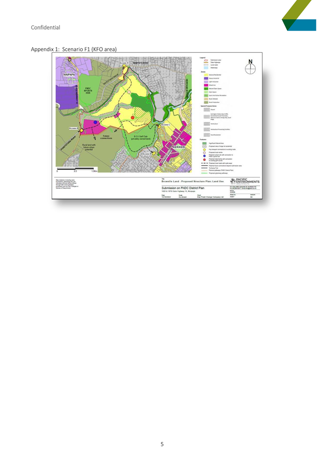
If this option is endorsed, the project team will stop developing the Kerikeri-Waipapa Spatial Plan, maintaining the status quo and leaving the area without a long-term growth strategy. The status quo results in growth being directed by the PDP, which is limited to what was notified and requested for via a submission. Currently the PDP as notified does not provide sufficient long-term greenfield growth options to meet projected demand. The only large-scale greenfield submission that can be considered is the land owned by Kiwi Fresh Group (“scenario F”). A district plan should be directed by a spatial plan on long term growth requirements. Without this direction growth will continue to be ad hoc and developer led.
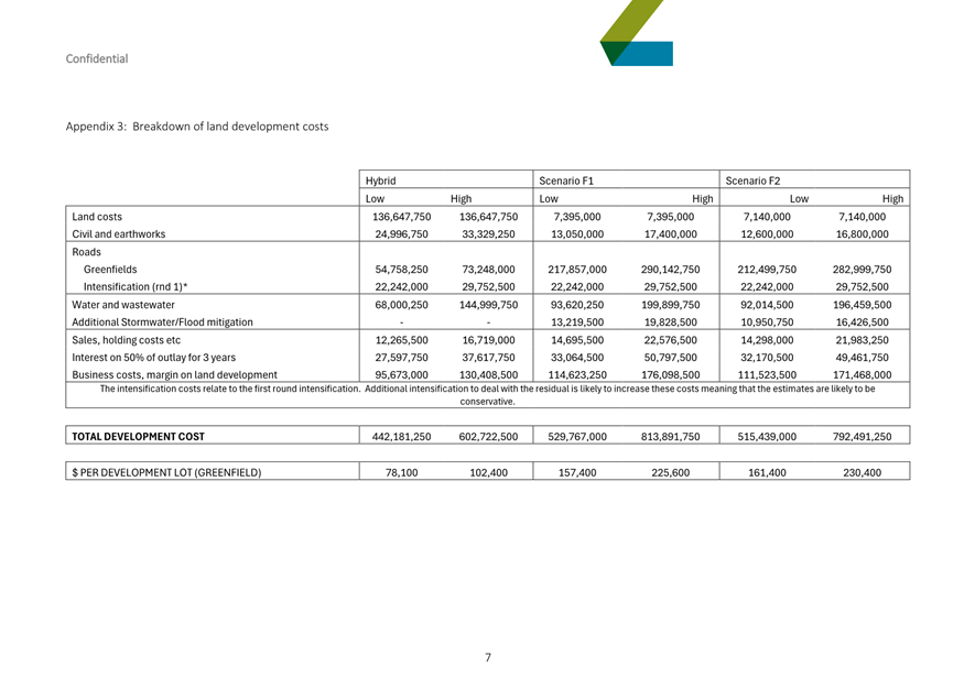
With no clear guidance for cost-effective infrastructure development, future development is likely to be expensive and inefficient. The estimated infrastructure costs for the status quo (PDP as notified) are $76M to $137M, which enables intensification of the existing urban areas but no new greenfield housing areas. If the PDP process supports the KFO submission for urban land use, this would result in the establishment of housing in a flood plain. Scenario F also has the highest total infrastructure costs across all potential greenfield options considered ($205.4M to $345.8M, see Option D below for more detail on these figures).
Under this option, the well-understood issues of fragmented residential and commercial development, inefficient and poorly planned infrastructure, car dependency, housing unaffordability and environmental degradation are likely to continue, with Kerikeri and Waipapa over time becoming less liveable and less attractive.
This option is likely to result in public criticism of Council for failing to deliver a long-term growth strategy (after several years and consultation processes) and will result in Council staff redoing spatial planning for the area as part of the District Wide Spatial Strategy project, which is in the very early stages of development. Not adopting a spatial plan will weaken the district’s position in relation to regional spatial planning work under a reformed resource management system and in relation to the reformed three waters system.
Not having a spatial plan will severely restrict Council’s ability to formulate a comprehensive development contributions policy with associated levies. It will be challenging for Council to distinguish between required maintenance and upgrades to achieve levels of service versus new infrastructure required to service growth. A development contributions policy must be informed by growth planning.
Advantages:
· Responds directly to the 42% of submitters who oppose the draft spatial plan (28% due to scenario F’s exclusion; 14% opposed to the draft spatial in general)
· the role and function of the Kerikeri / Waipapa area can be planned as part of the district wide spatial strategy.
Disadvantages:
· undermines Council’s Infrastructure Strategy, water services planning, and Long-Term Plan by preventing accurate infrastructure costing (specifically undefined greenfield servicing requirements) and weakening future funding strategies including development contributions)
· there is no longer a spatial plan to guide good urban design and long-term planning the PDP hearings, which relies on Te Pātukurea to guide
· leaves Kerikeri–Waipapa without a long-term growth strategy, leading to ad hoc development, inefficient infrastructure, and higher long-term costs
· unlikely to improve housing choice or affordability
· fails to meet community expectations for a sound, long-term growth and urban change framework
· contradicts the majority recommendation (6 of 8) from the Hapū Rōpū Governance Group. All members in one way or another want a spatial plan for the area
· cancelling Te Pātukurea will require costly rework under the district-wide spatial strategy and weaken the district’s position in upcoming regional spatial planning under Resource Management Act 1991 (RMA) reforms
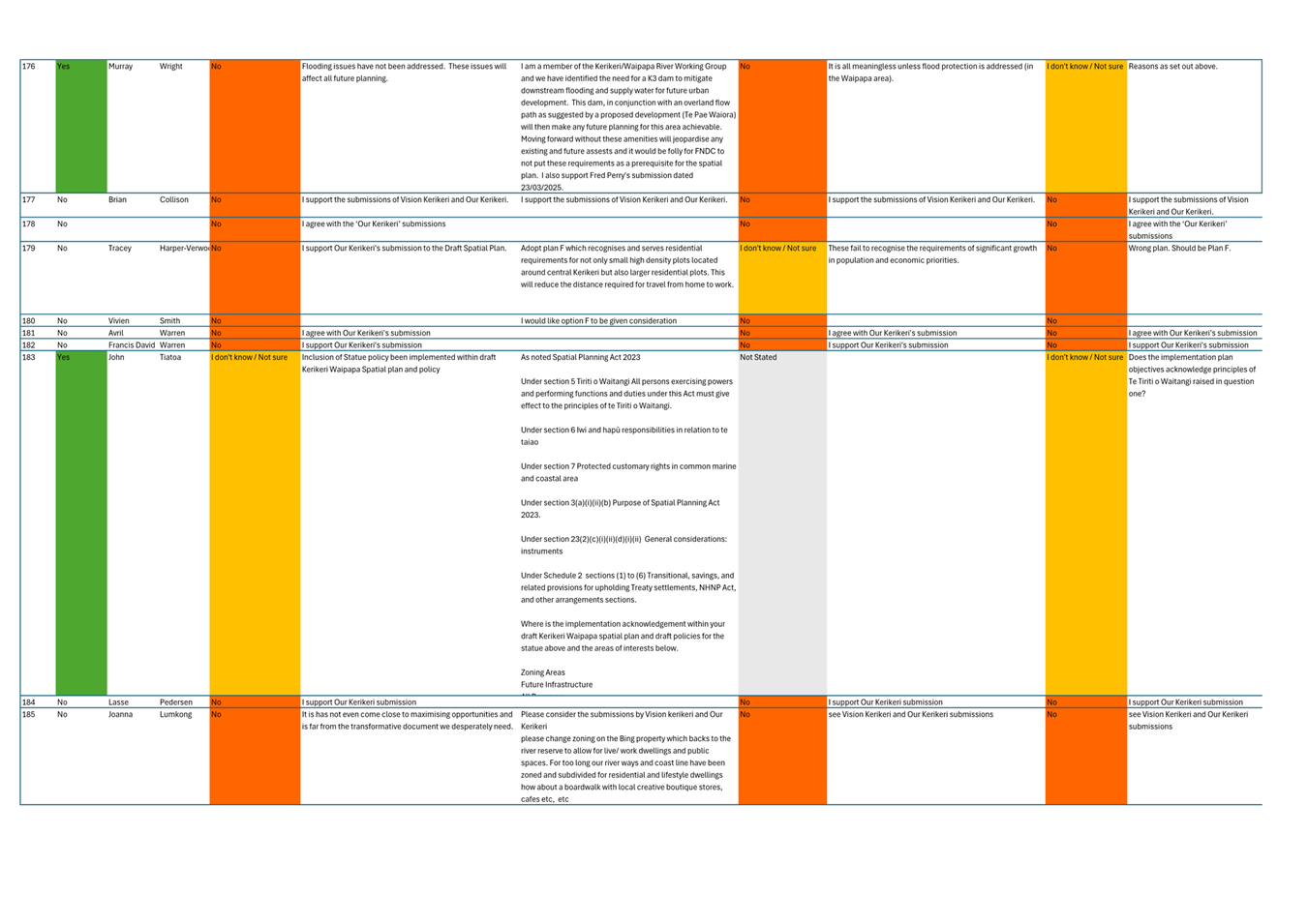
· disregards three years of input from elected members, hapū, and the community. Without new evidence or shifts in public opinion, any future plan would likely mirror Te Pātukurea
· risks community frustration from repeated consultations and unfinished planning work
· decisions on long term planning will be made by a new Council, which may not have the institutional knowledge of the last three years of plan making.
Option D: i) Do not adopt the spatial plan and ii) revise the draft spatial plan to include scenario F, and iii) defer or continue decision making on this project during Pre-Election period starting July 2025.
Under this option, Council would not adopt the current spatial plan but instead begin work on a revised draft that includes some or all of scenario F. This would require further public consultation.
Scenario F is incompatible with Te Pātukurea’s core objectives and principles as it does not enable resilient infrastructure, lacks connectivity, and based on cost estimates to date, is not expected to deliver affordable infrastructure.
Including scenario F will require rewriting and consulting on the plan’s core framework—its objectives, growth principles, and urban design principles. It is unlikely that scenario F can be incorporated into the existing spatial plan without fundamentally revisiting the principles and objectives that underpin the spatial plan. These changes are unlikely to be supported by existing technical analysis and by subject matter experts.
Reintroducing a previously discounted scenario would contradict earlier community feedback, which strongly supported avoiding hazard-prone areas and promoting well-planned, efficient growth. It would also run counter to current best practice in planning and urban design.
Due to the scale of work involved, final adoption of a revised plan would fall to the incoming Council in 2026. Council must also consider whether to continue or defer work on this option during the pre-election period (July–October 2025), noting the potential for public criticism if decisions are made during that time.
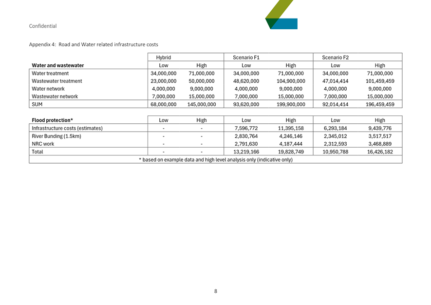
The infrastructure costs estimates for water supply, wastewater and transport network upgrades are $132M to $243M, these estimates were used to evaluate scenario F as a potential growth scenario. However, scenario F also requires additional infrastructure listed below.
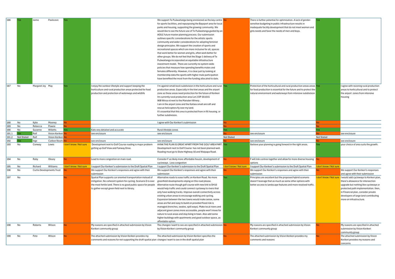
· building two new and one upgraded vehicle bridges over the Puketōtara Stream and Kerikeri River ($60M to $80M)
· adding a new round-about to SH10 ($2.5M to $3M)
· internal roads including over Kerikeri Golf Club land ($150M to $200M)[2] and
· installing onsite flood mitigation[3] ($10.9M to $19.8M).
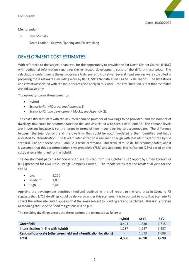
If scenario F is included in the spatial plan and subsequently upzoned through the Far North district plan, it is the most expensive greenfield area to develop, taking into account all required infrastructure. Ultimately these costs will transfer to the end purchaser and will result in higher costs to council as we have a responsibility to service urban growth. The average development contributions policy only recovers approximately 25% of infrastructure costs, with the balance of costs being met by ratepayers. Council takes on the responsibility of servicing the new urban area(s) and needs to consider that. We recognise that in many instances, works internal to the site will be funded by the developer, but even when that is considered, scenario F is still a much higher cost to service, compared to the draft spatial plan (refer Attachment 6 Development Cost Comparisons Memo)
In total the cost estimates for infrastructure required to service scenario F (excluding internal road costs) are $205.4M to $345.8M, which would need to be added to the cost estimates associated with servicing some of the hybrid scenario (brownfield and greenfield growth). This is because scenario F is not assessed as having sufficient land area to meet Te Pātukurea’s blue sky growth projections (4690 houses over 30 years) and because submitters in favour of scenario F generally suggest it should be added to the hybrid growth scenario. Further costs of maintaining flood defences in perpetuity would need to be factored in.
Including this option in the spatial plan would undermine the spatial plan’s strategic intent, impose substantial costs and risks and conflict with existing policy. This option also carries with it several reputational risks.
Advantages:
· responds directly to the 28% of submitters who opposed the draft plan due to exclusion of scenario F
· opportunity to test community sentiment regarding including a previously excluded growth scenario in the draft spatial plan and re-test community sentiment on related topics such as development in a flood plain, compact growth and protection of productive land.
Disadvantages:
· Flood risk: About 45% of the area is flood-prone, posing significant risks to life, property, and infrastructure. Flood plain development contradicts best practice and contradicts national and regional policy direction as noted below. It would also likely impose long-term costs on Council (ratepayer) for flood protection and recovery.
· High infrastructure costs: Scenario F demands extensive investment, these costs—estimated at $205.4M to $345.8M, —would likely fall to ratepayers/landowners, with no current mechanism to force the recovery of full funds or full commitment from developer. Even with the introduction of development contributions, the majority of infrastructure costs will fall to ratepayers if Council is aligned with national development contribution policy ratios. The ongoing management of assets (potentially including flood mitigation) will fall to Council along with liability and risk associated with any failure of the asset.
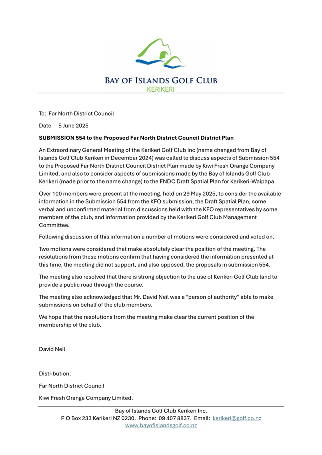
· Regulatory uncertainty: Approvals for flood defences, transport corridors, and land use changes are uncertain. The Kerikeri Golf Club passed a motion on 29 May 2025 that confirmed they oppose and do not support the submission (for urban zoning) on the Proposed District Plan made by Kiwi Fresh Orange Company Ltd on the Scenario F site. Further they confirmed a strong objection to the use of Kerikeri Golf Club land to provide a public road through the golf course (see Attachment 5 – letter from Kerikeri Golf Club dated 5 June 2025). This means Council will likely have to use the Public Works Act (at Council’s cost) for compulsory acquisition of land to achieve the transport connection to scenario F.
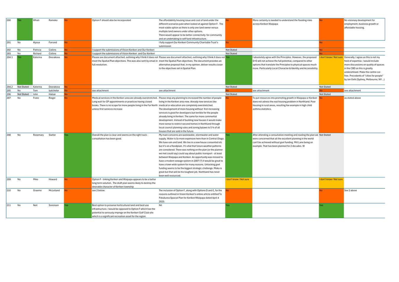
· Excessive development costs: The scale and complexity of required works would drive up costs for Council and the end landowner. It will also not achieve housing choice and affordable outcomes.
· Oversupply and inefficiency: If scenario F is added to the hybrid scenario, this would result in an oversupply of residential land, inflating infrastructure costs, weakening town centres, and hindering coordinated, cost-effective growth. Reconsulting will require us to revisit the entire spatial plan including all growth distribution to avoid oversupply
· Loss of productive land: Around 89% of the area is classified as highly productive under the NPS-HPL, which prioritises land for primary production. Though changes to LUC3 protections have been signalled, other protections (e.g. Special Agricultural Areas) are likely to remain. Their local impact remains unclear
· Precautionary principle: Given uncertainties around future land-use protections, Council should apply the precautionary principle and avoid fragmenting productive agricultural land and supporting new greenfield residential areas in flood zones
· Disconnected growth: Physical barriers—rivers, SH10, and the golf course—separate this area from existing towns, limiting integration and conflicting with NPS-UD goals for well-connected urban form.
· Conflict with Te Pātukurea: Scenario F contradicts the draft plan’s core goals—especially on sustainability, compact growth, and hazard avoidance.
· Lack of support: Scenario F is generally not supported by central government submissions, most (6 of 8) hapū representatives, regional agencies, and a key landholding (the Golf Club) required to enable the transport connection promoted for scenario F. Public consultation in late 2024 showed limited community backing – an important reason it was not identified as preferred growth option.
Policy Conflicts or gaps
Including scenario F would place the Kerikeri–Waipapa spatial plan in direct conflict with central, regional, and local policy, all of which oppose sprawl and development in hazard-prone areas.
· Northland Regional Policy Statement: Contradicts directives to minimise hazard risks and avoid inappropriate floodplain development. Also contradicts directive to maintain productive land/versatile soil, which was identified as key issue 2.4 in the Regional Policy Statement (RPS).
· National Policy Statement – Highly Productive Land: Breaches the requirement to protect productive land unless no viable alternatives exist
· National Policy Statement on Urban Development: Fails to support a well-functioning urban environment due to:
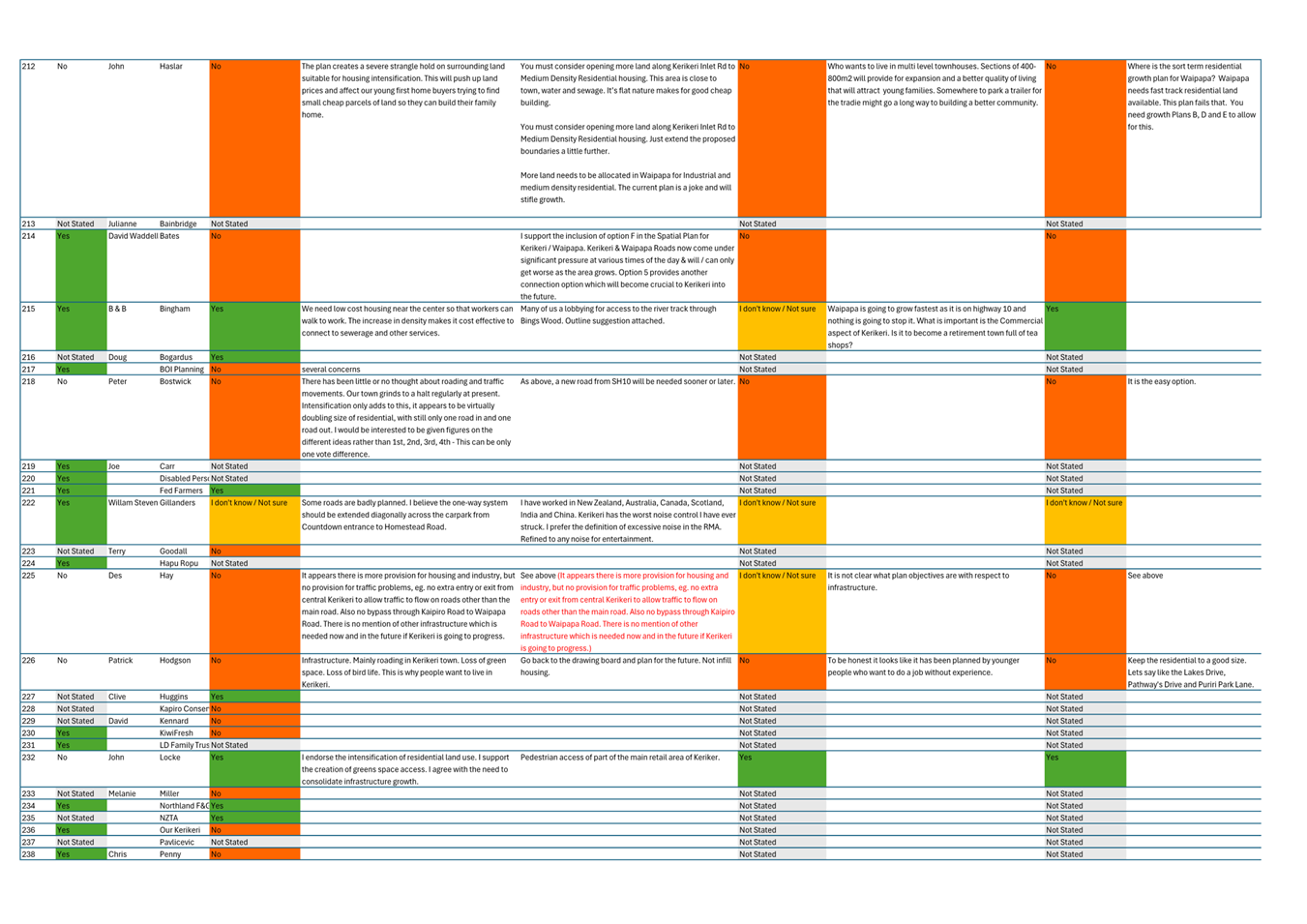
o limited housing variety and affordability (due to flood mitigation costs and land ownership patterns)
o dispersed, inefficient development
o poor accessibility, weak connectivity, and low climate resilience
· Proposed District Plan: Undermines the spatial plan’s intent to guide the PDP hearings
· FNDC Climate Action Policy (2023): Conflicts with Council’s commitment to account for climate risks, build resilience, and prioritise long-term sustainability
· Far North 2100 Strategy (2021): Inconsistent with goals for sustainable economic growth, climate resilience, future-proofing infrastructure, and protecting productive soils.
Reputational Risks
Including scenario F in the spatial plan presents several reputational risks:
· undermines a best-practice process built on three years of expert input and public consultation
· enables risky, flood-prone development, increasing future costs for ratepayers and potential liability for Council
· invites public criticism for delays, repeated consultation, and perceived waste of time and resources
· diverts staff from priority projects, including the district-wide spatial strategy aligned with Resource Management Act 1991 reform and the Long-Term Plan
· may appear to favour a vocal 28% of the community despite clear risks and limited community support
· disregards the views of 39% of submitters—including central agencies and rangatahi—who back the current draft plan
· re-consultation may not avoid a difficult political decision, as community support for including scenario F in the spatial plan may continue to be divided
· not having a spatial plan to direct the PDP hearings may result in reputational risk, and a need to re-open hearings if a spatial plan is adopted before Council decisions are made. This would result in Council have to ask for a further extension of time from the Ministry for Environment and delay new rules becoming operative.
Submissions (28%) requested Council to consider adding scenario F to the spatial plan (in addition to retaining greenfield areas already in the plan) contingent on all of scenario F’s constraints, risks and costs being addressed. However, this option would expose Council to potential judicial review as it does not comply with our obligations under the Local Government Act 2002. The draft spatial plan was taken out for public consultation only showing the hybrid growth scenario. It would carry high legal risk to adopt a spatial plan that includes growth areas that were not included in the draft spatial plan taken out for consultation. Further, the constraints, risks and costs associated with scenario F preclude the land from meeting the objectives and growth principles of Te Pātukurea, therefore this has not been put forward as an option.
TAKE TŪTOHUNGA / REASON FOR THE RECOMMENDATION
Option A is recommended for the following reasons:
· Te Pātukurea is a sound, evidence-based plan, grounded in high quality community and stakeholder engagement and consultation
· ongoing community involvement in key planning processes, such as structure planning, is enabled via the implementation plan, and monitoring and evaluation of plan outcomes is built in, meaning the plan can be adapted over time, in response to new information or circumstances
· the spatial plan as proposed achieves the objectives for growth agreed with the community, and reflects majority of Hapū Rōpū Governance Body and community aspirations
· the spatial plan provides certainty to all stakeholders in relation to the future urban development of Kerikeri and Waipapa
· the spatial plan avoids any issues with hazard-prone future development areas, as the simplest, cheapest and most secure development option is to avoid flood prone greenfield sites
· all uncertainties and costs associated with greenfield development in a flood plain, such as flood defences, complex infrastructure and perpetual maintenance costs are avoided
· all negative consequences of locating future urban development in an inappropriate site are avoided. These include, significant additional infrastructural costs, the loss of highly productive land and the development of a dis-integrated urban form that locks in development inefficiencies and costs forever
· adopting the spatial plan maintains the integrity of the overall process and avoids reputation risks associated with revising the spatial plan to include a previously discounted, inappropriate growth scenario and not having a plan in place to guide the PDP hearings
· not adopting the spatial plan will lead to inferior, long-term outcomes for Kerikeri and Waipapa and the current issues of fragmented development, inefficient infrastructure, and limited housing choice and affordability will persist
· the likelihood of a successful legal challenge to the plan or process is low.
3) PĀnga PŪtea me ngĀ wĀhanga tahua / Financial Implications and Budgetary Provision
The costs associated with developing the document - Te Pātukurea - have been budgeted for within the financial year 24/25 cost centre for the growth planning and placemaking team. There will be future operational costs associated with implementing the spatial plan.
The implementation plan has been supported and reviewed by the relevant department that will have responsibility for this work and therefore costs will be covered by the relevant operation budget as required dependent on the work program in place.
There are infrastructure costs that will need to be funded in the future to give effect to the spatial plan; decisions on funding the necessary infrastructure will need to occur as part of the next long-term plan process (or equivalent Local Waters Done Well process). To manage those financial costs the spatial plan has been written to be undertaken in stages (short, medium, long term), with a focus first on brownfield development in Kerikeri where there is existing infrastructure already in place. As part of the implementation plan a funding strategy will be created that will look at mechanisms such as connection charges, development contribution and financial contribution fees. This will allow Council to manage its budget, cashflow and rating impacts.
1. Te
Pātukurea Draft Spatial Plan Consultation Summary Report Including
Attachments - A5224909 ⇩ ![]()
2. Te
Pātukurea Draft Spatial Plan Deliberations Report Including Attachments -
A5224910 ⇩ ![]()
3. Memo
Describing Amendments to Te Pātukurea - A5224912 ⇩ ![]()
4. Te
Pātukurea Kerikeri Waipapa Spatial Plan with Amendments - A5224911 ⇩ ![]()
5. Kerikeri
Golf Club Letter Opposing KFO Submission - A5224908 ⇩ ![]()
6. Te
Pātukurea Development Cost Comparisons - A5231077 ⇩ ![]()
Hōtaka Take Ōkawa / Compliance Schedule:
Full consideration has been given to the provisions of the Local Government Act 2002 S77 in relation to decision making, in particular:
1. A Local authority must, in the course of the decision-making process,
a) Seek to identify all reasonably practicable options for the achievement of the objective of a decision; and
b) Assess the options in terms of their advantages and disadvantages; and
c) If any of the options identified under paragraph (a) involves a significant decision in relation to land or a body of water, take into account the relationship of Māori and their culture and traditions with their ancestral land, water sites, waahi tapu, valued flora and fauna and other taonga.
2. This section is subject to Section 79 - Compliance with procedures in relation to decisions.
|
He Take Ōkawa / Compliance Requirement |
Aromatawai Kaimahi / Staff Assessment |
|
State the level of significance (high or low) of the issue or proposal as determined by the Council’s Significance and Engagement Policy |
In accordance with Council’s Significance and Engagement Policy, this decision is not assessed a being of high significance as it does not involve the transfer of ownership or control of astrategic asset, and it is not inconsistent with Councilplans or policies. The decision is of medium significance given the level of local public interest, and divided nature of that interest in this proposal. The draft spatial plan was publicly consulted on via the Special Consultative Procedure under the Local Government Act, due to the anticipated level of public interest in this decision. |
|
State the relevant Council policies (external or internal), legislation, and/or community outcomes (as stated in the LTP) that relate to this decision. |
The Resource Management Act 1991 National Policy Statement – Urban Development 2020 National Policy Statement – Highly Productive Soils 2022 Local Government Act 2002 Northland Regional Policy Statement Far North District Council Proposed District Plan FNDC Climate Adaptation Policy 2023 Far North 2100 2021 Proposed National Policy Statement on Natural Hazards |
|
State whether this issue or proposal has a District wide relevance and, if not, the ways in which the appropriate Community Board’s views have been sought. |
Kerikeri Waipapa is projected to cater for approximately 50% of growth in the district over the next 30 years. However, Te Pātukurea is considered to be of most relevance to the Bay of Islands – Whangaroa Community Board and their views have been sought and incorporated throughout this project by included all board members at the numerous workshops held across the duration of this project. |
|
State the possible implications for Māori and how Māori have been provided with an opportunity to contribute to decision making if this decision is significant and relates to land and/or any body of water. State the possible implications and how this report aligns with Te Tiriti o Waitangi / The Treaty of Waitangi. |
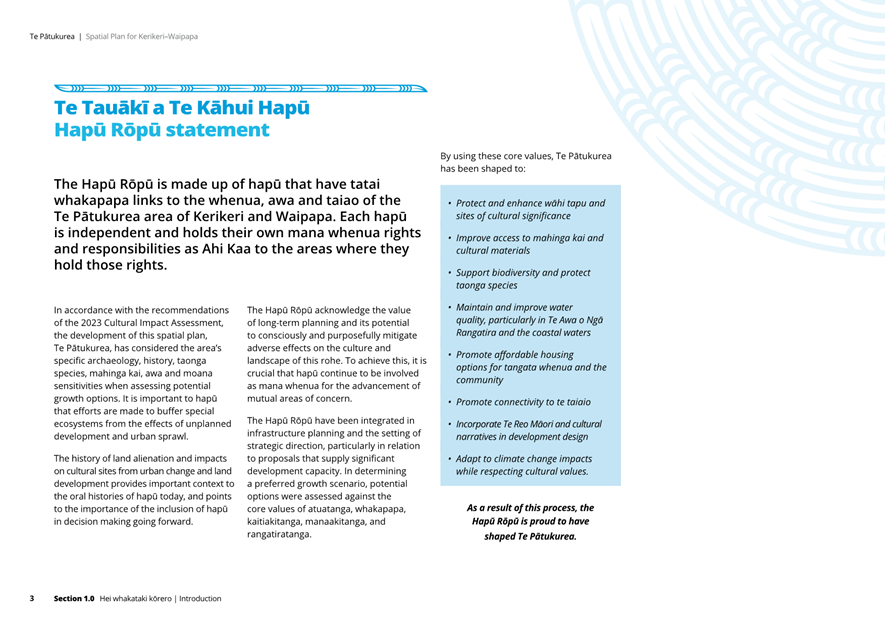
Long-term growth planning has many implications for Māori. At the commencement of this project, a Hapū Rōpū Governance Body was established with mandated representation for eight local hapū. These hapū are: Ngāti Hineira Ngāti Korohue Ngāti Mau Ngāti Rangi Ngāti Rēhia Ngāti Torehina ki Matakā Te Uri Taniwha Te Whiu The Rōpū supported the draft spatial plan to go out for public consultation in March 2025, however at the conclusion of that consultation, two hapū (Ngāti Rēhia and Ngāti Hineira) no longer fully support the draft spatial plan, instead favouring a previously discounted growth scenario (F). |
|
Identify persons likely to be affected by or have an interest in the matter, and how you have given consideration to their views or preferences (for example – youth, the aged and those with disabilities). |
There are numerous community groups who have been engaged throughout the project via a mix of targeted stakeholder engagement and invitation to submit formally on three rounds of public engagement. |
|
State the financial implications and where budgetary provisions have been made to support this decision. |
There are no direct financial implications associated with making this decision however adoption of a spatial plan signals the short, medium and long-term direction for long-term growth and infrastructure planning, which will require future Council decision making to allocate funds for the necessary land use zone changes and provision of infrastructure. Adoption of a spatial plan supports and integrated approach to long term land use and infrastructure planning, generally resulting in more efficient and affordable infrastructure. It will also require other work to be done such as funding strategy, that will require a number of teams to collaborate on. |
|
Chief Financial Officer review. |
The Chief Financial Officer has reviewed this report. |
|
Extraordinary Council Meeting Agenda |
18 June 2025 |
|
Extraordinary Council Meeting Agenda |
18 June 2025 |
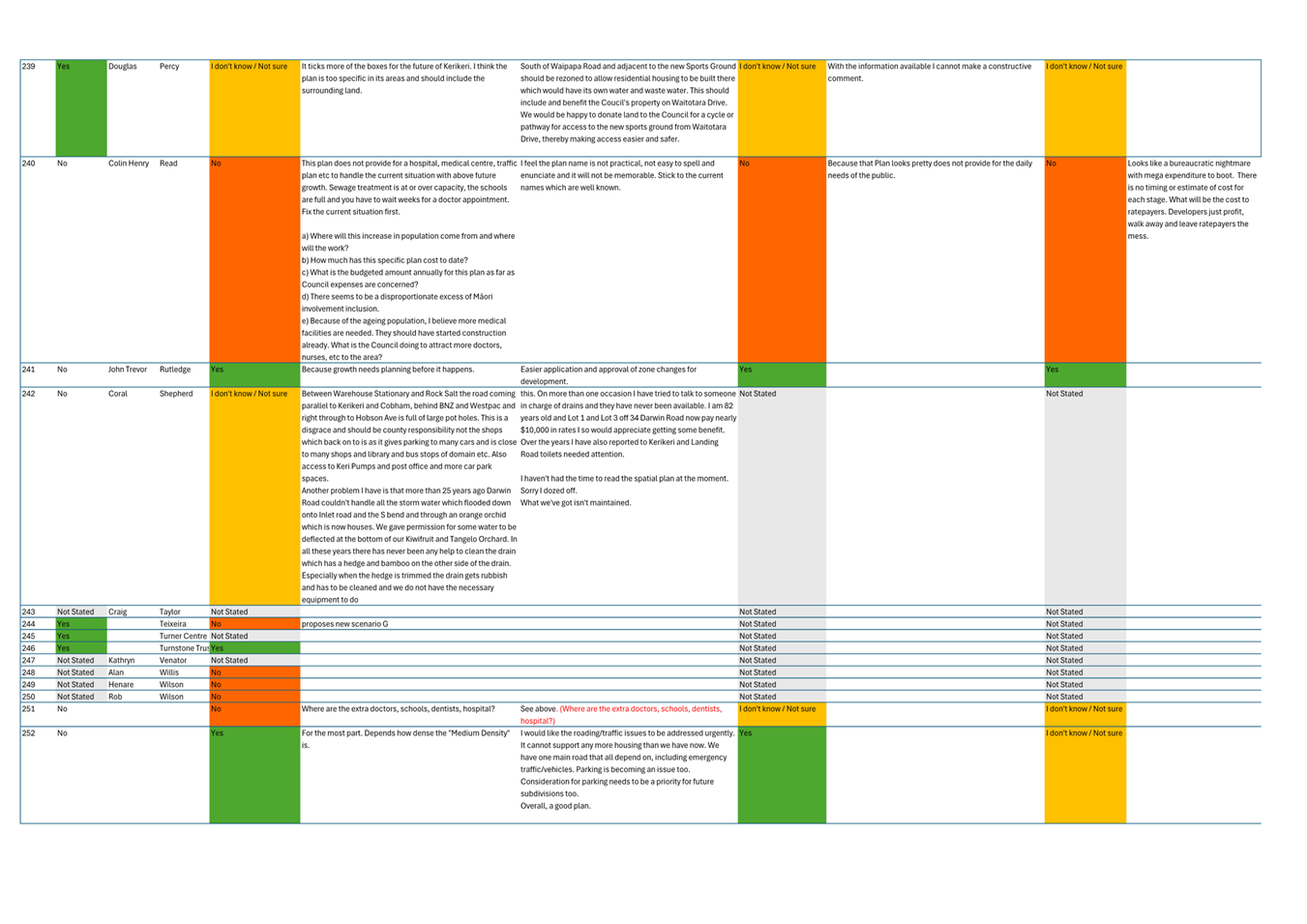
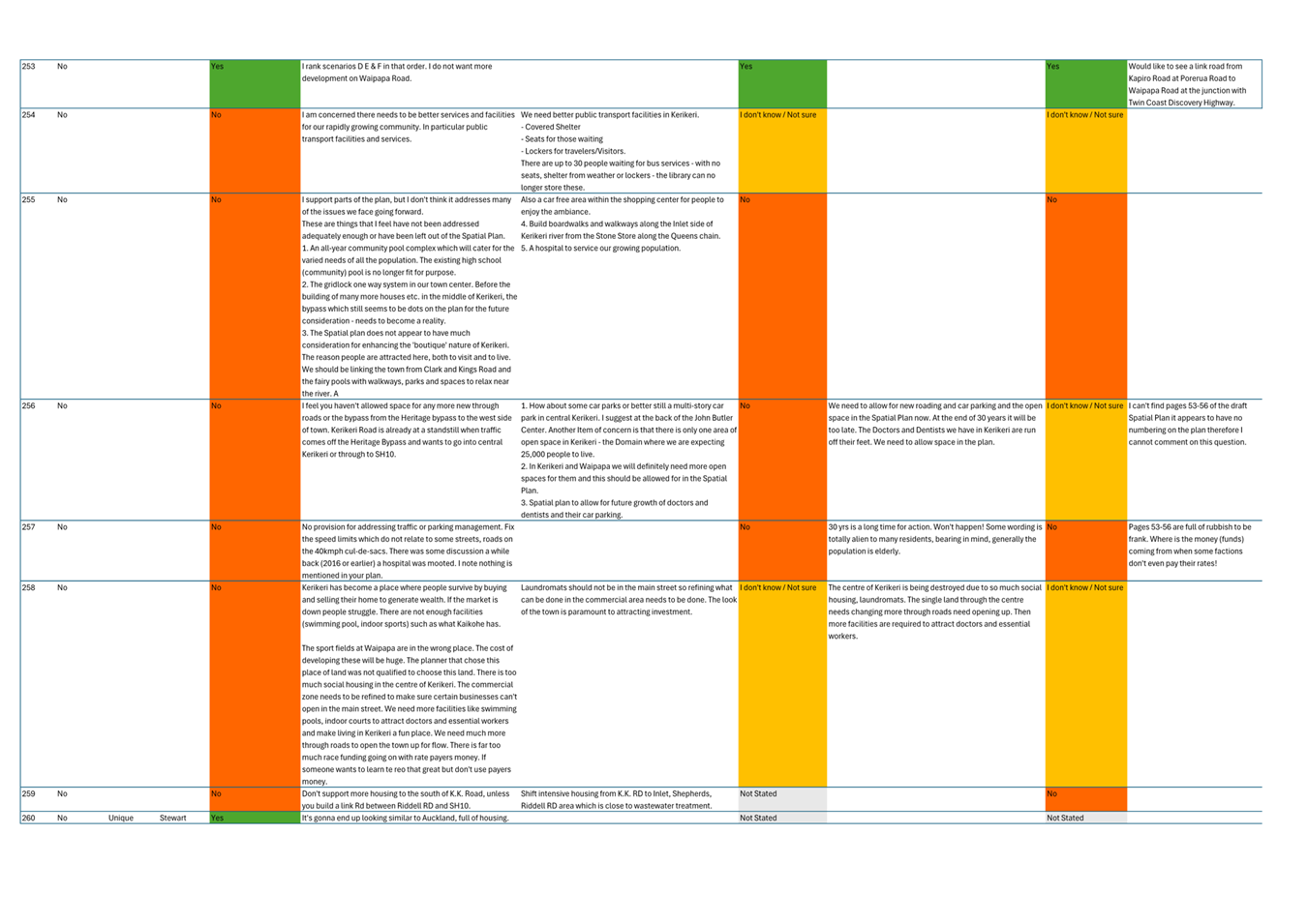
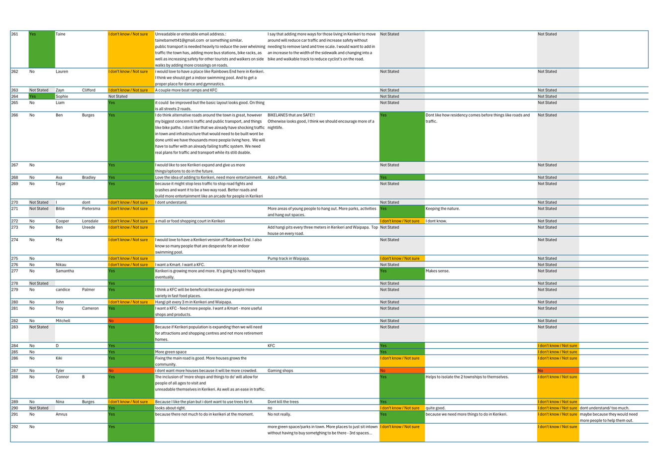
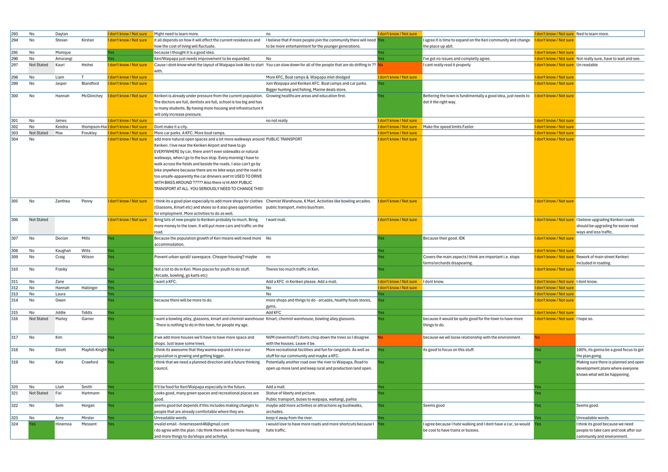
Te Pātukurea Draft Spatial Plan Deliberations Report Including Attachments.
This attachment is available under separate cover.
|
18 June 2025 |
6 Te Wāhanga Tūmataiti / Public Excluded
RESOLUTION TO EXCLUDE THE PUBLIC
|
That the public be excluded from the following parts of the proceedings of this meeting. The general subject matter of each matter to be considered while the public is excluded, the reason for passing this resolution in relation to each matter, and the specific grounds under section 48 of the Local Government Official Information and Meetings Act 1987 for the passing of this resolution are as follows:
|
7 Karakia Whakamutunga / Closing Prayer
[1] Counts and percentages are calculated based on total responses to each consultation question
[2] Indicative cost estimates for bridges, round-about and roading sourced by the project’s external transport SME
[3] The flood mitigation estimates are high-level and based on information sourced from other studies into flood mitigation. In addition, information about the infrastructure investment associated with the Otiria Spillway, as well as information from NRC were used and scaled to reflect recent price increases and the contemplated size of the flood protection. Crucially, the financial information is seen as proxies for the scenario F assessment