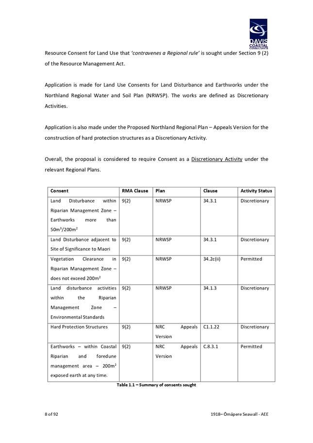
KAIKOHE-HOKIANGA COMMUNITY BOARD

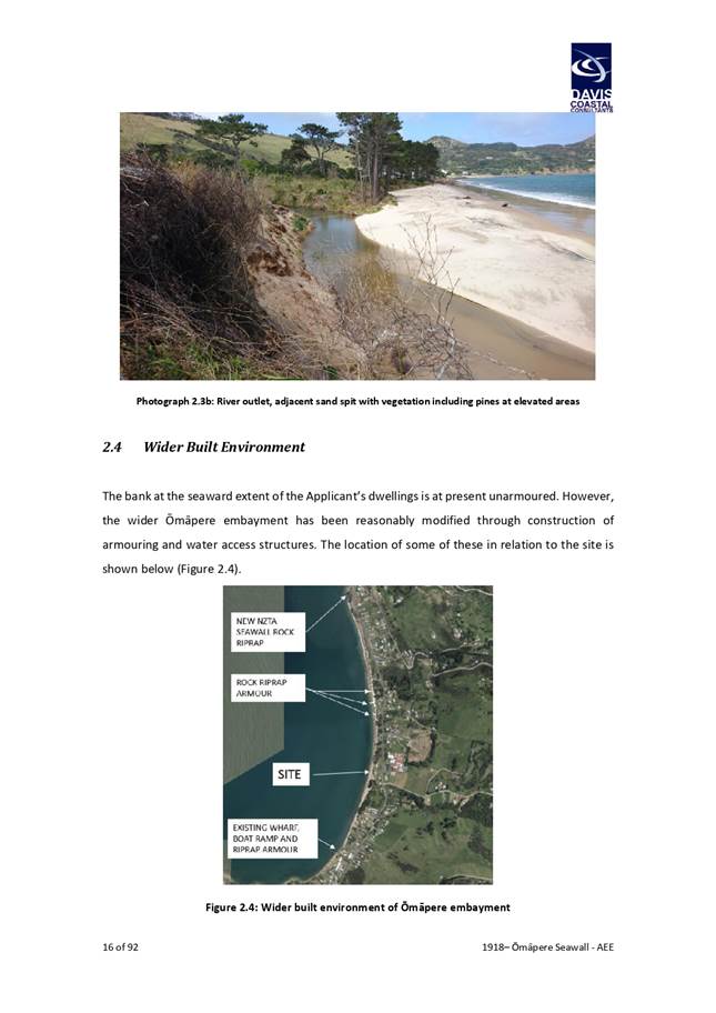
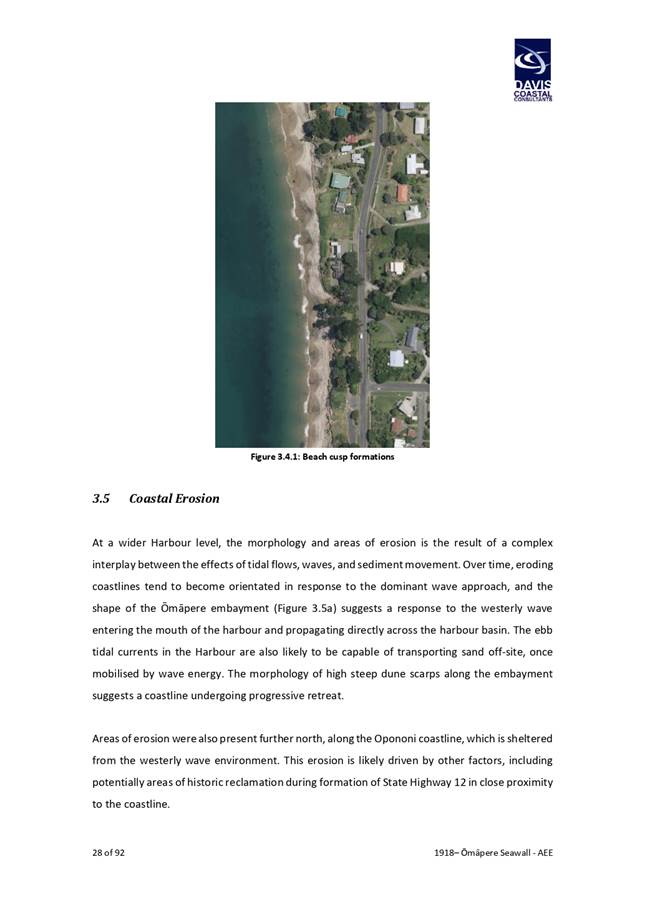
Tanemahuta
- Waipoua Forest
AGENDA
Kaikohe-Hokianga Community Board Meeting
Wednesday, 2 June 2021
|
Time:
|
10.30 am
|
|
Location:
|
Council Chamber
Memorial Avenue
Kaikohe
|
Membership:
Chairperson Mike Edmonds
Deputy Chairperson Emma Davis
Member Laurie Byers
Member Kelly van Gaalen
Member Alan Hessell
Member Moko Tepania
Member Louis Toorenburg
Member John Vujcich
|
Kaikohe-Hokianga
Community Board Meeting Agenda
|
2 June 2021
|
The Local Government Act 2002 states the
role of a Community Board is to:
(a) Represent, and act as an
advocate for, the interests of its community.
(b) Consider and report on
all matters referred to it by the territorial authority, or any matter of
interest or concern to the community board.
(c) Maintain an
overview of services provided by the territorial authority within the
community.
(d) Prepare an annual
submission to the territorial authority for expenditure within the community.
(e) Communicate with community
organisations and special interest groups within the community.
(f) Undertake any
other responsibilities that are delegated to it by the territorial authority
Council Delegations to Community Boards - January
2013
The "civic amenities" referred to in
these delegations include the following Council activities:
·
Amenity lighting
·
Cemeteries
·
Drainage (does not include reticulated
storm water systems)
·
Footpaths/cycle ways and walkways.
·
Public toilets
·
Reserves
·
Halls
·
Swimming pools
·
Town litter
·
Town beautification and maintenance
·
Street furniture including public
information signage.
·
Street/public Art.
·
Trees on Council land
·
Off road public car parks.
·
Lindvart Park – a
Kaikohe-Hokianga Community Board civic amenity.
Exclusions: From time to time Council may consider some activities and
assets as having district wide significance and these will remain the
responsibility of Council. These currently include: The roading network,
Hundertwasser toilets, District Library Network, Baysport, the Kerikeri,
Kaikohe & Kaitaia Airports, Hokianga Vehicle Ferry, i-Site network, Far
North Community Centre, Kerikeri Domain, Kawakawa Heated Swimming Pool, Kaikohe
Cemetery, Kerikeri Sports Complex, The Centre at Kerikeri, the Bay of
Islands/Hokianga Cycle Trail.
Set local priorities for minor capital works
in accordance with existing strategies,
1.
Recommend local service levels and
asset development priorities for civic amenities as part of the Annual Plan and
Long-Term Plan processes.
2.
Reallocate capital budgets within the
Annual Plan of up to 5% for any specific civic amenity, provided that the overall
activity budgetary targets are met.
3.
Make grants from the allocated
Community Funds in accordance with policy 3209, and the SPARC/Sport Northland
Rural Travel fund in accordance with the criteria set by the respective body,
and, for the Bay of Islands-Whangaroa Community Board, the power to allocate
the Hundertwasser Donations Account.
4.
Provide comment to council staff on
resource consent applications having significance within the Community,
including the provision of land for reserves or other public purposes.
5.
To hold, or participate in hearings, as
the Council considers appropriate, in relation to submissions pertinent to
their community made to plans and strategies including the Long-Term Plan and
Annual Plan, and if appropriate recommend decisions to the Council.
6.
To hold hearings of submissions
received as a result of Special Consultative Procedures carried out in respect
of any matter other than an Annual or Long-Term Plan and make recommendations
to the Council.
7.
Where recommended by staff to appoint
management committees for local reserves, cemeteries, halls, and community
centres.
8.
To allocate names for previously
unnamed local roads, reserves and other community facilities, and recommend to
Council name changes of previously named roads, reserves, and community
facilities subject to consultation with the community.
9.
To consider the provisions of new and
reviewed reserve management plans for recommendation to the Council in
accordance with the Reserves Act 1977 and hear or participate in the hearing of
submissions thereto, as considered appropriate by the Council.
10.
To provide recommendations to the
Council in respect of applications for the use and/or lease of reserves not
contemplated by an existing reserve management plan.
11.
Prohibit the use of skateboards in
specified locations within their communities, in accordance with
Council’s Skating Bylaw 1998.
12.
Recommend new bylaws or amendments to
existing bylaws.
13.
Prepare and review management plans for
local cemeteries within budget parameters and in a manner consistent with
Council Policy.
14.
Exercise the following powers in
respect of the Council bylaws within their community:
a. Control of Use of Public Spaces – Dispensations on
signs
b. Mobile Shops and Hawkers – Recommend places where
mobile shops and/or hawkers should not be permitted.
c. Parking and Traffic Control – Recommend parking
restrictions, and areas where complying camping vehicles may park, and consider
and grant dispensations in accordance with clause 2007.2
d. Public Places Liquor Control – Recommend times and
places where the possession or drinking of alcohol should be prohibited.
e. Speed Limits – Recommend places and speed limits
which should be imposed.
15.
To appoint Community Board members to
speak on behalf of their community in respect of submissions or petitions.
16.
Specific to the Bay of
Islands-Whangaroa Community Board – consider any recommendations of the
Paihia Heritage Working Group and make appropriate recommendations to Council
on the development of a draft Plan Change and a Section 32 analysis on heritage
provisions for Paihia.
17.
To set schedule of meeting dates, times
and venues, subject to the meetings not conflicting with meetings of the
Council and satisfying the provisions of the Local Government Official
information and Meetings Act 1987.
18.
To review all proposed public art
projects on a project-by project basis to ensure they comply with policy #5105
Art in Public Places, including approval of the aesthetic appearance,
maintenance programme, insurance and appropriate location, and to agree to
their installation.
19.
In respect of applications from food
establishments for permission to establish tables and chairs on a public place,
i.e. Alfresco dining in accordance with Policy 3116, to consider and decide on
any application which does not meet all criteria of the policy, and any
application which staff recommend to be declined.
20.
Subject to a report from the
appropriate managers and the appropriate budgetary provision, to make decisions
in respect of civic amenities including the levels of service, and the
provision or removal of an amenity not provided for elsewhere in these
delegations.
Terms of Reference
In fulfilling its role and giving effect to its
delegations, Community Boards are expected to:
1.
Comment on adverse performance to the
Chief Executive in respect of service delivery.
2.
Assist their communities in the
development of structure plans, emergency management community response plans,
and community development plans.
3.
Assist their communities to set
priorities for Pride of Place programmes.
4.
Have special regard for the views of
Maori.
5.
Have special regard for the views of
special interest groups, e.g. disabled, youth, aged, etc.
6.
Actively participate in community
consultation and advocacy and keep Council informed on local issues.
7.
Seek and report to Council community
feedback on current issues by:
a. Holding a Community forum prior to Board meetings
b. Varying the venues of Board meetings to enable access by
members of the community
8.
Monitor and make recommendations to
Council to improve effectiveness of policy.
9.
Appoint a member to receive Annual
Plan\Long Term Council Community Plan submissions pertinent to the Board area,
attend hearings within the Board area, and attend Council deliberations prior
to the Plan adoption.
Protocols
In supporting Community Boards to fulfil their
role, the Council will:
1.
Provide appropriate management support
for the Boards.
2.
Organise and host regular workshops
with the Community Boards l to assess the 'State of the Wards & District'
to establish spending priorities.
3.
Prior to decision-making, seek and
include 'Community Board views' in Council reports in relation to:
a. the disposal and purchase of land
b. proposals to acquire or dispose of reserves
c. representation reviews
d. development of new maritime facilities
e. community development plans and structure plans
f. removal and protection of trees
g. local economic development initiatives
h. changes to the Resource Management Plan
4.
Organise and host quarterly meetings
between Boards, the CEO and senior management staff.
5.
Prepare an induction/familiarisation
process targeting new members in particular early in the term.
6.
Support Board members to arrange
meetings with local agencies and service clubs to place more emphasis on
partnerships and raising profile of the Boards as community leaders.
7.
Permit Board chairperson (or nominated
member) speaking rights at Council meetings.
8.
Help Boards to implement local
community projects.
9.
Arrange for Infrastructure and Asset
Management Staff to meet with the Community Boards in September each year to
agree the capital works for the forthcoming year for input into the Annual or
Long-Term Plan.
10.
Provide information.
KAIKOHE-HOKIANGA
COMMUNITY BOARD MEMBERS REGISTER OF INTERESTS
|
Name
|
Responsibility
(i.e. Chairperson etc)
|
Declaration
of Interests
|
Nature
of Potential Interest
|
Member's
Proposed Management Plan
|
|
Mike Edmonds
|
Chair
|
Kaikohe Mechanical and
Historic Trust
|
Council Funding
|
Decide at the
time
|
|
Committee member
|
Kaikohe Rugby Football
and Sports Club
|
Council Funding
|
Withdraw and abstain
|
|
Kelly van Gaalen
|
No form received
|
|
|
|
|
Louis Toorenburg
|
No form received
|
|
|
|
|
Alan Hessell
|
Nil
|
Nil
|
Nil
|
Nil
|
|
Laurie Byers
|
Kaikohe Golf Club
|
|
|
|
|
Kaikohukohu Trust
|
|
|
|
|
North Point Trust
|
|
|
|
|
Patron Bay of Islands
Hockey
|
|
|
|
|
Emma Davis
|
Secretary
|
Pompallier Hokianga
Trust
|
Council Funding
|
Decide at the time to
withdraw and/or abstain
|
|
Trustee
|
Raiatea Resource Centre
|
Council Funding
|
Decide at the time to
withdraw and/or abstain
|
|
Committee Member
|
Rawene Hall
|
Council Funding
|
Decide at the time to
withdraw and/or abstain
|
|
Committee Member
|
Kohukohu Hall
|
Council Funding
|
Decide at the time to
withdraw and/or abstain
|
|
Member of teaching
staff
|
Broadwood Area School
|
Council Funding
|
Decide at the time to
withdraw and/or abstain
|
|
John Vujcich
|
Board Member
|
Pioneer Village
|
Matters relating to
funding and assets
|
Declare interest and
abstain
|
|
Director
|
Waitukupata Forest Ltd
|
Potential for council
activity to directly affect its assets
|
Declare interest and
abstain
|
|
Director
|
Rural Service Solutions
Ltd
|
Matters where council
regulatory function impact of company services
|
Declare interest and
abstain
|
|
Director
|
Kaikohe (Rau Marama)
Community Trust
|
Potential funder
|
Declare interest and
abstain
|
|
Partner
|
MJ & EMJ Vujcich
|
Matters where council
regulatory function impacts on partnership owned assets
|
Declare interest and
abstain
|
|
Member
|
Kaikohe Rotary Club
|
Potential funder, or
impact on Rotary projects
|
Declare interest and
abstain
|
|
Member
|
New Zealand Institute
of Directors
|
Potential provider of
training to Council
|
Declare a Conflict of
Interest
|
|
Member
|
Institute of IT
Professionals
|
Unlikely, but possible
provider of services to Council
|
Declare a Conflict of
Interest
|
|
Moko Tepania
|
Teacher
|
Te Kura Kaupapa Māori o Kaikohe.
|
Potential Council funding that will benefit my place of employment.
|
Declare a perceived conflict
|
|
Chairperson
|
Te Reo o Te Tai Tokerau Trust.
|
Potential Council funding for events that this trust runs.
|
Declare a perceived conflict
|
|
Tribal Member
|
Te Rūnanga o Te Rarawa
|
As a descendent of Te Rarawa I could have a perceived conflict of
interest in Te Rarawa Council relations.
|
Declare a perceived conflict
|
|
Tribal Member
|
Te Rūnanga o Whaingaroa
|
As a descendent of Te Rūnanga o Whaingaroa I could have a
perceived conflict of interest in Te Rūnanga o Whaingaroa Council
relations.
|
Declare a perceived conflict
|
|
Tribal Member
|
Kahukuraariki Trust Board
|
As a descendent of Kahukuraariki Trust Board I could have a perceived
conflict of interest in Kahukuraariki Trust Board Council relations.
|
Declare a perceived conflict
|
|
Tribal Member
|
Te Rūnanga ā-Iwi o Ngāpuhi
|
As a descendent of Te Rūnanga ā-Iwi o Ngāpuhi I could
have a perceived conflict of interest in Te Rūnanga ā-Iwi o
Ngāpuhi Council relations.
|
Declare a perceived conflict
|
1 Nga Whakapāha Me Ngā Pānga Mema / Apologies
and Conflicts of Interest
Members need to
stand aside from decision-making when a conflict arises between their role as a
Member of the Community Board and any private or other external interest they
might have. This note is provided as a reminder to Members to review the
matters on the agenda and assess and identify where they may have a pecuniary
or other conflict of interest, or where there may be a perception of a conflict
of interest.
If a Member
feels they do have a conflict of interest, they should publicly declare that at
the start of the meeting or of the relevant item of business and refrain from
participating in the discussion or voting on that item. If a Member thinks they
may have a conflict of interest, they can seek advice from the Chief Executive
Officer or the Team Leader Democracy Support (preferably before the meeting).
It is noted
that while members can seek advice the final decision as to whether a conflict
exists rests with the member.
2 Public
Forum
3 Te Tono Kōrero / Deputation
Jon Phelong representing He Waka Kotahi
4 Speakers
Bay of Islands Canine Association
Kaikohe and Districts Sportsville
5 Confirmation
of Previous Minutes
5.1 Confirmation
of Previous Minutes
File
Number: A3052583
Author: Marlema
Baker, Meetings Administrator
Authoriser: Aisha
Huriwai, Team Leader Democracy Services
Purpose of the Report
The minutes are attached to allow the Kaikohe-Hokianga
Community Board to confirm that the minutes are a true and correct record of
the previous meeting.
|
Recommendation
That the Kaikohe-Hokianga Community Board
confirms the minutes of their meeting held 12 May 2021 as a true and correct
record.
|
1) Background
Local Government Act 2002 Schedule 7 clause 28 states that a
local authority must keep minutes of its proceedings. The minutes of
these proceedings duly entered and authenticated as prescribed by a local
authority are prima facie evidence of those meetings.
2) Discussion and Options
The unconfirmed minutes of the meeting are attached.
The Kaikohe-Hokianga Community Board Standing Orders Section
3.17.3 states that “no discussion may arise on the substance of the
minutes at any succeeding meeting, except as to their correctness”.
Reason
for the recommendation
The reason for the recommendation is to confirm the minutes
as a true and correct record of the previous meeting.
3) Financial Implications and Budgetary
Provision
There are no financial implications or the need for
budgetary provision.
Attachments
1. 2021-05-12
Kaikohe-Hokianga Community Board Minutes [A3188657] - A3188657 ⇩ 
|
Kaikohe-Hokianga
Community Board Meeting Agenda
|
2 June 2021
|
MINUTES OF
Kaikohe-Hokianga
Community Board Meeting
HELD AT THE Council
Chamber, Memorial Avenue, Kaikohe
ON Wednesday, 12 May
2021 AT 10.30
am
PRESENT: Chairperson
Mike Edmonds, Member Emma Davis, Member Louis Toorenburg, Member Kelly van
Gaalen, Member Alan Hessell, Member Laurie Byers, Member John Vujcich.
IN
ATTENDANCE:
STAFF
PRESENT: Marlema Baker (Meetings Advisor), Kathryn Trewin (Funding Advisor)
1 NGā WHAKAPāHA ME NGā PāNGA MEMA / Apologies and conflicts of Interest
|
1a Apologies and Conflicts of Interest
|
|
Resolution 2021/33
Moved: Chairperson
Mike Edmonds
Seconded: Member
Alan Hessell
That:
a) the
apology from member Moko Tepania be accepted and a leave of absence granted.
b) the
apology from member Emma Davis for lateness be accepted.
Carried
|
2 Public
Forum
· Shaun
Reilly opposes the implementation of Maori Wards and hopes Council reconsiders
their decision.
3 Ngā Tono KŌrero / Deputations
· Phil
Grimshaw spoke regarding Healthy Families (document tabled).
· John
Klaricich (on behalf of Ian Mackenzie) spoke regarding Pakanae Urupa (document
tabled).
· Liz
Owen spoke regarding Okaihau Playcentre.
4 Speakers
· Ana
Heremaia – Ākau Design: funding applications 7.4a and 7.4b refers.
§ 7.4b – Te Reo Maori signage
in Kaikohe Streetscape and waiata Maori to be recorded.
§ 7.4a – Bling Bling event -
needs a big structure to house mahi over 4 days.
· Tania
Filia – Omanaia Marae 7.4d refers – Omanaia Marae.
· Seeks funding for
bi-fold fold out tables.
· Cheryl
Smith – Rural Travel Fund speaking on behalf of Sport Northland:
· Kathryn Trewin to
provide a report to the August 2020 Community Board meeting regarding making an
application to Sport Northland to increase funding for the Kaikohe-Hokianga
ward.
· Chair Edmonds raised the
possibility of the Kaikohe-Hokianga Community Board augmenting some of the
Rural Travel funding needed to supplement the needs of the Kaikohe-Hokianga
ward.
Meeting adjourned 11:55 am – 12:49 pm
5 Notice
of Motion
|
5.1 Kaikohe-Hokianga
Notice of Motion - Okaihau Playcentre Reserve
Agenda item 6.1 document number
A3181638, pages 12 - 12 refers
|
|
Resolution 2021/34
Moved: Chairperson
Mike Edmonds
Seconded: Member
John Vujcich
That, pursuant to the Local
Government Act 2002, Schedule 7, Cl 32(6), the Kaikohe-Hokianga Community
Board requests that the Council consider delegating governance responsibility
for the reserve land upon which the Okaihau Playcentre sits to the KHCB
to the fullest extent possible, and that the Kaikohe-Hokianga Community Board
be delegated recommendation rights for all those powers not able to be
delegated.
Carried
|
6 Confirmation
of Previous Minutes
|
6.1 Confirmation
of Previous Minutes
Agenda item 7.1 document number
A3052579, pages 13 - 13 refers
|
|
Resolution 2021/35
That the Kaikohe-Hokianga Community Board
confirms the minutes of their meeting held 7 April 2021 as a true and correct
record.
Carried
|
7 Reports
|
7.1 Kaikohe-Hokianga
Community Board Hokianga Spraying Commiittee
Agenda item 8.1 document number
A3181642, pages 18 - 20 refers
|
|
Resolution 2021/36
Moved: Member
Louis Toorenburg
Seconded: Member
Alan Hessell
That the Kaikohe-Hokianga Community Board adopt
the terms of reference for the Hokianga Spraying Committee as follows: that with regard to the herbicide and spraying in and around
Rawene the Hokianga Spraying Committee will:
a) represent,
and act as an advocate for, the interests of its community.
b) consider
and report on information provided and/or referred to it by the Far North
District Council.
c) prepare an
annual submission to the Far North District Council for expenditure within
the community; and
d) communicate
with interested parties within the community.
Carried
|
|
7.2 Kaikohe-Hokianga
Statement of Community Board Fund Account as at 31 March 2021
Agenda item 8.2 document number
A3160464, pages 23 - 24 refers
|
|
Resolution 2021/37
Moved: Member
John Vujcich
Seconded: Member
Emma Davis
That the Kaikohe-Hokianga Community Board
a)
receives the report Kaikohe-Hokianga Statement of
Community Board Fund Account as at 31 March 2021, and
b)
request that any unallocated funds from 2021 be rolled
over into the next financial year.
Carried
|
|
7.3 Winter
2021 Rural Travel Funding Applications
Agenda item 8.3 document number
A3155766, pages 27 - 30 refers
|
|
Resolution 2021/38
Moved: Member
John Vujcich
Seconded: Member
Louis Toorenburg
That the Kaikohe-Hokianga Community Board allocates
Rural Travel Grant funding in accordance with the recommendations received
from Sport Northland as follows:
a) Datz
Us Netball $2400
b) Hokianga
Sports Club $2000
c) Kaikohe
Rugby Football and Sports Club $3800
d) Kerikeri
Gymnastics Club $910
e) Mid
North United Sports $2300
f) Omanaia
School $800
g) Taiamai
Ohaeawai Junior Rugby Club $2000
h) Te
Kura a-Iwi o Pawarenga $350
i) Te
Kura Kaupapa Māori o Kaikohe $3042
j) Te
Kura Taumata o Panguru $1000
k) Rawene
Primary School $2000
Total
$20,602
Carried
|
|
7.4 FUNDING APPLICATIONS
Agenda item 8.4 document number A3169182, pages 86 - 91
refers
|
|
Resolution 2021/39
Moved: Member
Louis Toorenburg
Seconded: Member
Alan Hessell
7.4.a That the Kaikohe-Hokianga Community Board
approves the sum of $xxx (plus GST if applicable) be paid from the
Board’s Community Fund account to Ākau
Foundation for costs towards Bling Bling Toi Marama 2021 to
support the following Community Outcomes:
i) Communities
that are healthy, safe, connected and sustainable
ii) Proud, vibrant
communities
7.4.b That the Kaikohe-Hokianga Community Board
approves the sum of $xxx (plus GST if applicable) be paid from the
Board’s Community Fund account to Ākau
Foundation for costs towards Te Reo Māori on the
Streets to support the following Community Outcomes:
i) Communities
that are healthy, safe, connected and sustainable
ii) Proud, vibrant
communities
7.4.c That the Kaikohe-Hokianga Community Board
approves the sum of $xxx (plus GST if applicable) be paid from the
Board’s Community Fund account to Hokianga Treks 4 Kids
for costs towards clearing the Rawene horse track to
support the following Community Outcomes:
i) Communities
that are healthy, safe, connected and sustainable
ii) Proud, vibrant
communities
7.4.d That the Kaikohe-Hokianga Community Board
approves the sum of $xxx (plus GST if applicable) be paid from the
Board’s Community Fund account to Omanaia Marae
for costs towards tables and chairs for the whare kai
to support the following Community Outcomes:
i. Communities that are healthy,
safe, connected and sustainable
ii. Proud, vibrant communities
Carried
|
|
7.4.e RESOLUTION TO EXCLUDE THE PUBLIC
|
|
Resolution 2021/40
Moved: Chairperson
Mike Edmonds
Seconded: Member
Laurie Byers
That
the public be excluded from the following parts of the proceedings of this
meeting.
The general subject matter of each matter to be
considered while the public is excluded, the reason for passing this
resolution in relation to each matter, and the specific grounds under section
48 of the Local Government Official Information and Meetings Act 1987 for the
passing of this resolution are as follows:
|
General subject of each
matter to be considered
|
Reason for passing this
resolution in relation to each matter
|
Ground(s) under section 48
for the passing of this resolution
|
|
7.4 – Funding Applications
|
s7(2)(a) - the withholding of the
information is necessary to protect the privacy of natural persons,
including that of deceased natural persons.
s7(2)(f)(i) - free and frank expression of
opinions by or between or to members or officers or employees of any local
authority.
|
s48(1)(a)(i) - the public conduct of the relevant part
of the proceedings of the meeting would be likely to result in the
disclosure of information for which good reason for withholding would exist
under section 6 or section 7.
|
Carried
|
|
7.4.f Motion to move out of closed meeting into
open meeting
|
|
Resolution 2021/41
Moved: Chairperson
Mike Edmonds
Seconded: Member
John Vujcich
That the Kaikohe-Hokianga Community Board moves out of
closed meeting into open meeting.
Carried
|
|
7.4 Funding
Applications continued
Agenda item 8.4 document number
A3169182, pages 86 - 91 refers
|
|
Resolution 2021/42
Moved: Chairperson
Mike Edmonds
Seconded: Member
John Vujcich
7.4a That the Kaikohe-Hokianga Community Board approves
the sum of $7500 (plus GST if applicable) be paid from the Board’s
Community Fund account to Ākau Foundation
for costs towards Bling Bling Toi Marama 2021 and $7500 on
presentation of an invoice for 2022 to support the following Community
Outcomes:
i) Communities
that are healthy, safe, connected and sustainable
ii) Proud, vibrant
communities
7.4b That the Kaikohe-Hokianga Community Board approves
the sum of $10,000 (plus GST if applicable) be paid from the Board’s
Community Fund account to Ākau Foundation
for costs towards Te Reo Māori on the Streets to
support the following Community Outcomes:
i) Communities
that are healthy, safe, connected and sustainable
ii) Proud, vibrant
communities
7.4c That the Kaikohe-Hokianga Community Board approves
the sum of $1,500 (plus GST if applicable) be paid from the Board’s Community
Fund account to Hokianga Treks 4 Kids for costs
towards clearing the Rawene horse track to support the
following Community Outcomes:
i) Communities
that are healthy, safe, connected and sustainable
ii) Proud, vibrant
communities
7.4d That the Kaikohe-Hokianga Community Board approves
the sum of $2,450 (plus GST if applicable) be paid from the Board’s
Community Fund account to Omanaia Marae for costs
towards tables and chairs for the whare kai to
support the following Community Outcomes:
iii. Communities that are healthy, safe,
connected and sustainable
iv. Proud, vibrant communities
Carried
|
|
7.5 Project
Funding Reports
Agenda item 8.5 document number
A3169225, pages 120 - 121 refers
|
|
Resolution 2021/43
Moved: Member
Louis Toorenburg
Seconded: Member
Laurie Byers
That the Kaikohe-Hokianga Community Board note
the project reports received from:
a) Hokianga
Trek 4 Kids
b) Okaihau
Bowling Club – Kitchen
c) Okaihau
Bowling Club – Bowling Mats
d) He
Whakamanamai Whanau Trust
Carried
|
|
7.6 Rural
Travel Funding Reports
Agenda item 8.6 document number
A3170785, pages 134 - 135 refers
|
|
Resolution 2021/44
Moved: Member
John Vujcich
Seconded: Member
Alan Hessell
That the Kaikohe-Hokianga Community Board note
the project reports received from:
a) Hokianga
Sports Club
b) Rawene
Primary School
Carried
|
8 Information
Reports
|
8.1 Kaikohe-Hokianga
Statement of Financial Performance Activities by Ward for the period ending
31 March 2021
Agenda item 9.1 document number
A3160432, pages 142 - 142 refers
|
|
Resolution 2021/45
Moved: Member
John Vujcich
Seconded: Member
Laurie Byers
That the Kaikohe-Hokianga Community Board receives the
report Kaikohe-Hokianga Statement of Financial Performance Activities by Ward
for the period ending 31 March 2021.
Carried
|
9 tE kAPINGA hUI / Meeting
Close
The meeting closed at 2pm.
The minutes of this meeting were confirmed at the Kaikohe-Hokianga Community Board Meeting held on 2 June 2021.
...................................................
CHAIRPERSON
6 Reports
6.1 Proposal
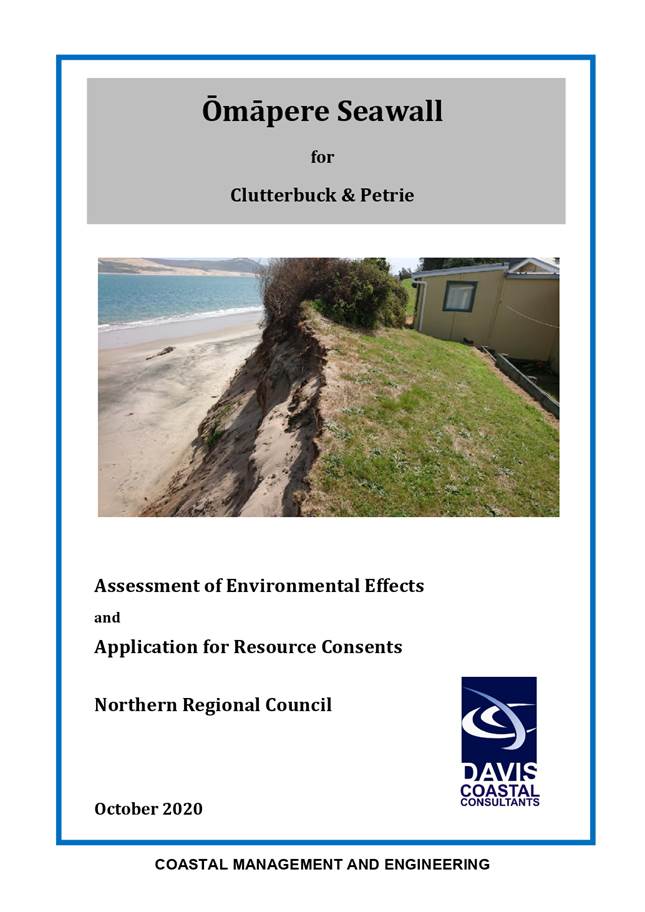
to Construct an Erosion Protection Structure on Council Owned Reserve, Omapere
File
Number: A3183735
Author: Ruben
Wylie, Principle Planner Infrastructure
Authoriser: Andy
Finch, General Manager - Infrastructure and Asset Management
Take Pūrongo / Purpose of the Report
To seek a decision from Council, via the Kaikohe-Hokianga
Community Board, for a request to construct an erosion protection structure
partially on Council owned local purpose reserve within the coastal environment
of Omapere.
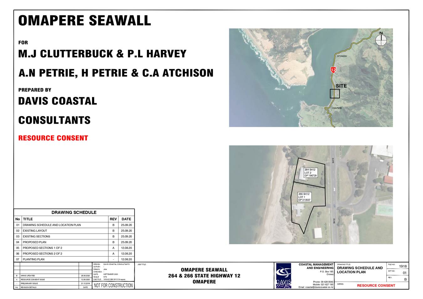
WhakarĀpopoto matua / Executive Summary
The owners of properties at 264 and 266 State Highway 12,
Omapere propose to construct an erosion protection structure adjacent to the
shoreline fronting their properties. The dwelling at these properties are at
risk of being affected by shoreline retreat. Council owned local purpose
reserve land is situated between the subject properties and toe of the dune
scarp on which the erosion protection structure is proposed to be built. A
portion of the proposed structure will be located within the boundary of this
reserve land. In keeping with the provisions of the Reserves Act 1977, and
Council’s Reserves Policy, approval of the proposal to occupy part of
local purpose reserve with an erosion protection structure sits with Council.
Staff recommendation is to approve the request.
|
tŪtohunga
/ Recommendation
That the Kaikohe-Hokianga Community Board recommend to
Council that it:
a) Approves
the construction of, and associated occupation with, an erosion protection
structure on Far North District Council owned local purpose reserved legally
described as Lot 5 DP196729; and
b) The
approval is provided subject to a memorandum of encumbrance being recorded on
the titles of Lot 1 DP196729 and Lot 1 DP310507 and that the encumbrance
records the agreement that the owners of those properties:
I. bear
full responsibility for the maintenance, repair, removal of the seawall (if
required) during its lifetime, and end of its lifetime.
II. incur
cost of the agreement construction and registration against title.
III. notify
FNDC of any variation or modification of the erosion protection structure
To avoid doubt, approval is given both within Council’s
capacity as the administering body of the reserve and an affected person
within the meaning of Section 95 of the Resource Management Act 1991.
|
1) TĀhuhu kŌrero / Background
The owners of
properties at 264 and 266 State Highway have lodged resource consent
applications with the Far North District Council and the Northland Regional
Council to allow for the construction of an erosion protection structure, and
ongoing occupation of space with the structure in the marine and coastal area.
The proposal is to construct the erosion protection structure on the seaward
side of FNDC owned reserve land. A portion of the structure will need to
be located within the reserve land. FNDC has accordingly been treated as an
affected party within the meaning of s95 of the Resource Management Act 1991
(RMA). The applicants have sought written approval from FNDC in its capacity as
the owner of the reserve land. Given the proposal is to occupy a portion of
FNDC reserve land, the consideration of written approval must also address the
requirements of the Reserves Act 1977.
Council’s
Reserve Policy sets out that decisions to allow occupation of reserves requires
a decision by Council. In keeping with Council policy, the matter is first
being brought to the Kaikohe-Hokianga Community Board for a subsequent
recommendation to Council.
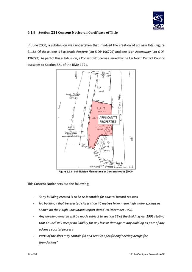
1.1) Application
Details
The proposal is to construct an erosion protection structure
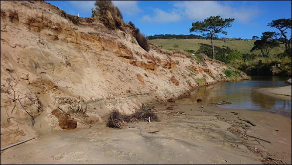
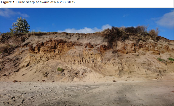
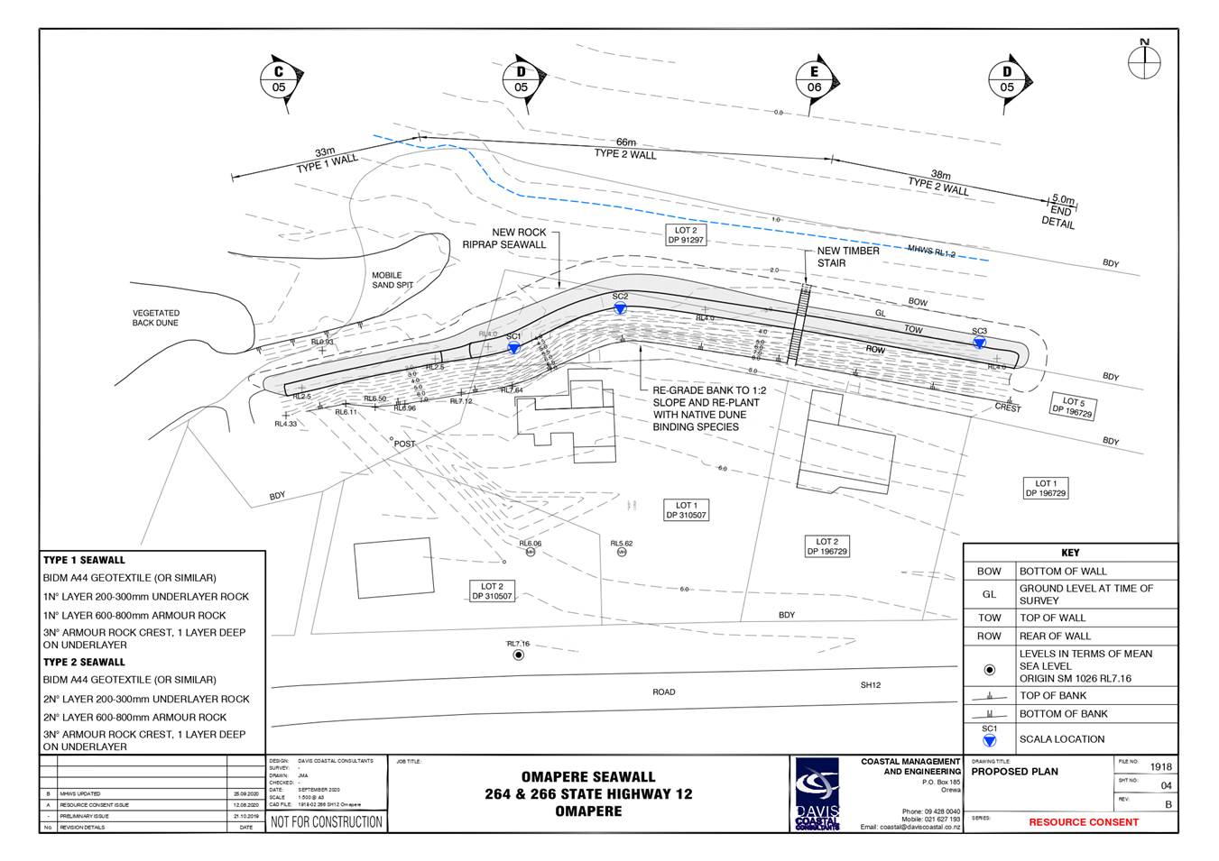
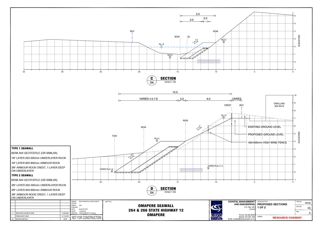
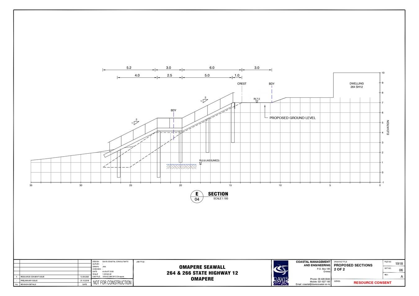
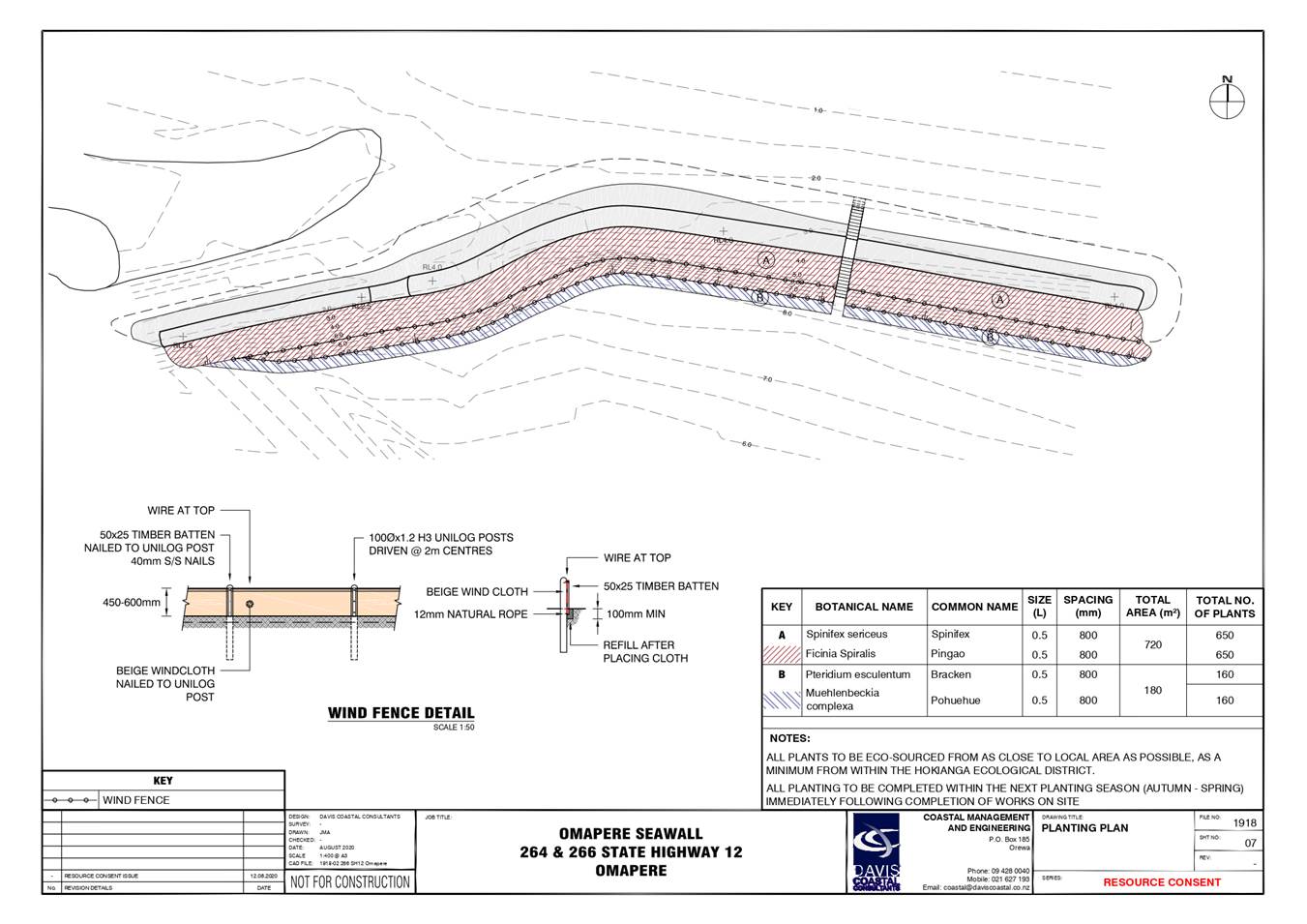
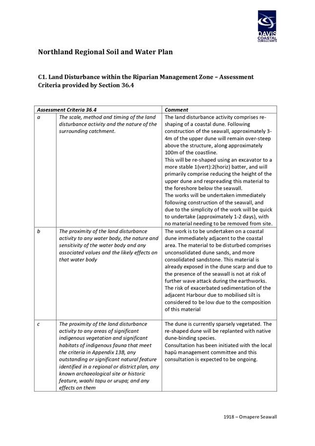
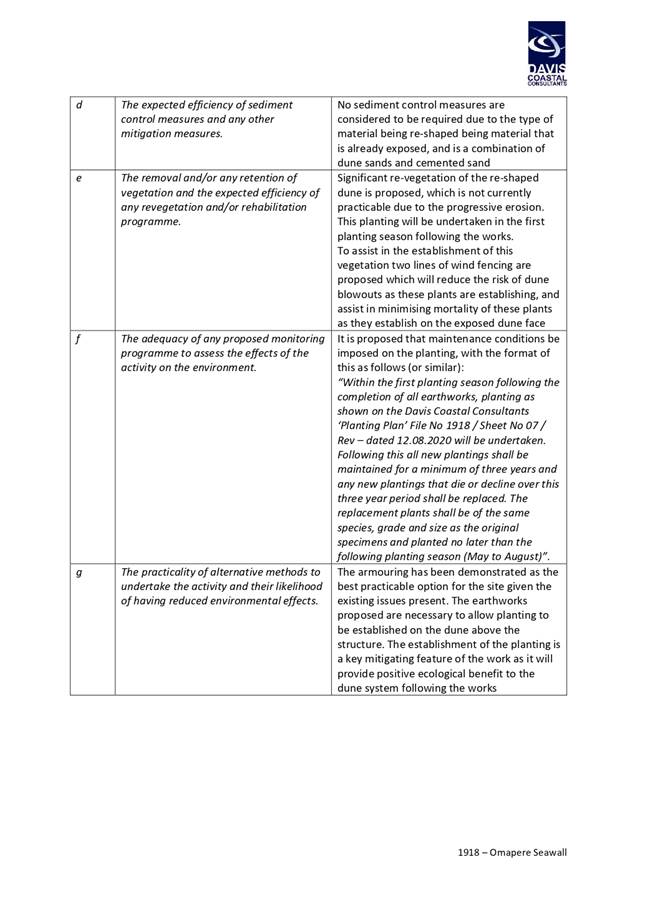
at the toe of a tall (5m high) sandy dune scarp at Omapere. The purpose of the
work is to protect the properties at 264 and 266 State Highway 12. These two
properties are located on the seaward side of state highway 12, opposite
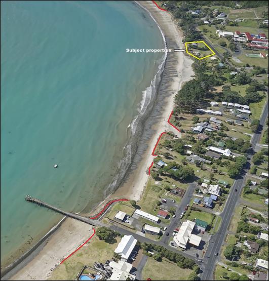
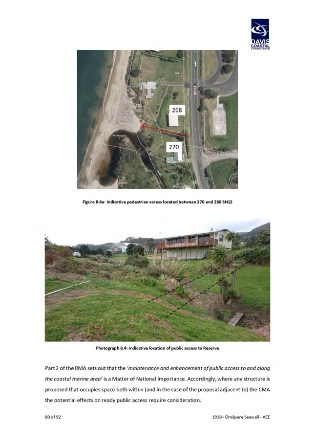
Opononi Area School. The approximate location of the subject site is shown in
Figure 1.

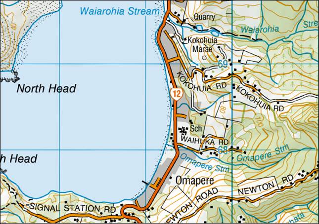
Figure
1. Location of the proposed erosion
protection work (red outline).
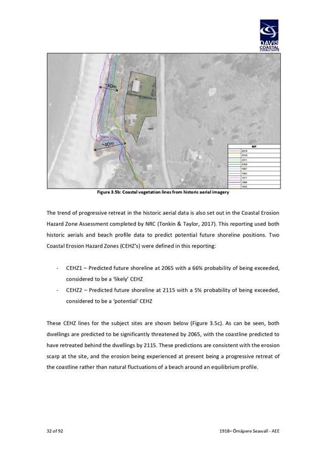
Cliff retreat driven by erosion of the dune toe is
threatening the properties. Both dwellings on each property are in close
proximity to the scarp. The property at No 266 being closest, with
approximately 2-3m between parts of the dwelling and the headscarp of the dune.
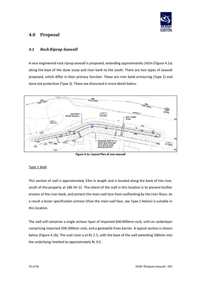
The seawall is to comprise of an engineered riprap
structure, extending approximately 142m along the base of the dune scarp. Details
of the structure are included in the assessment of environmental effects
prepared for the resource consent application. That assessment is attached as
Attachment 1.
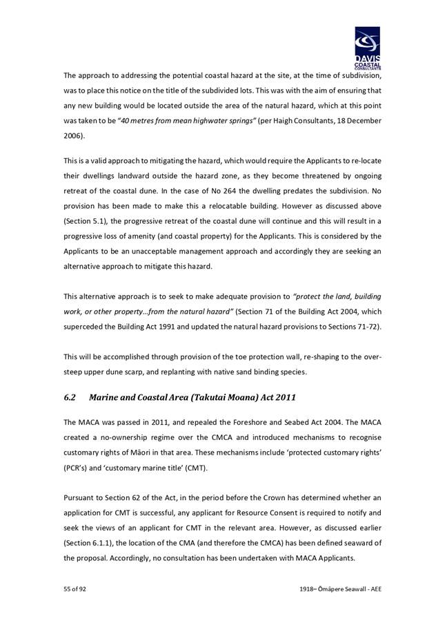
1.2) Affected
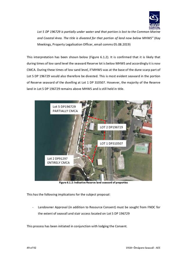
reserve land
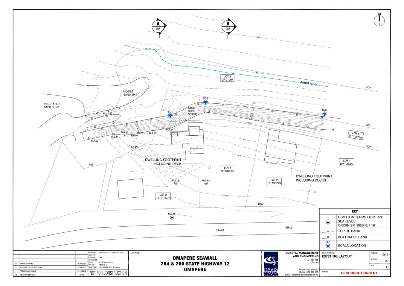
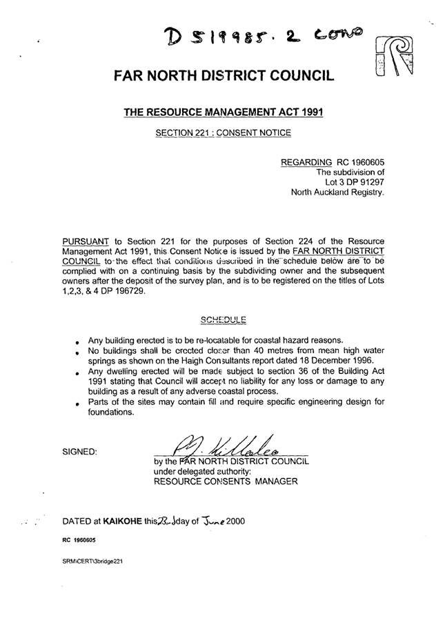
Two parcels of Esplanade Reserve land are located seaward of
the subject properties, legally described as Lot 5 DP196729 and Lot 2 DP91297
and are both Local Purpose reserves within the meaning of the Reserves Act
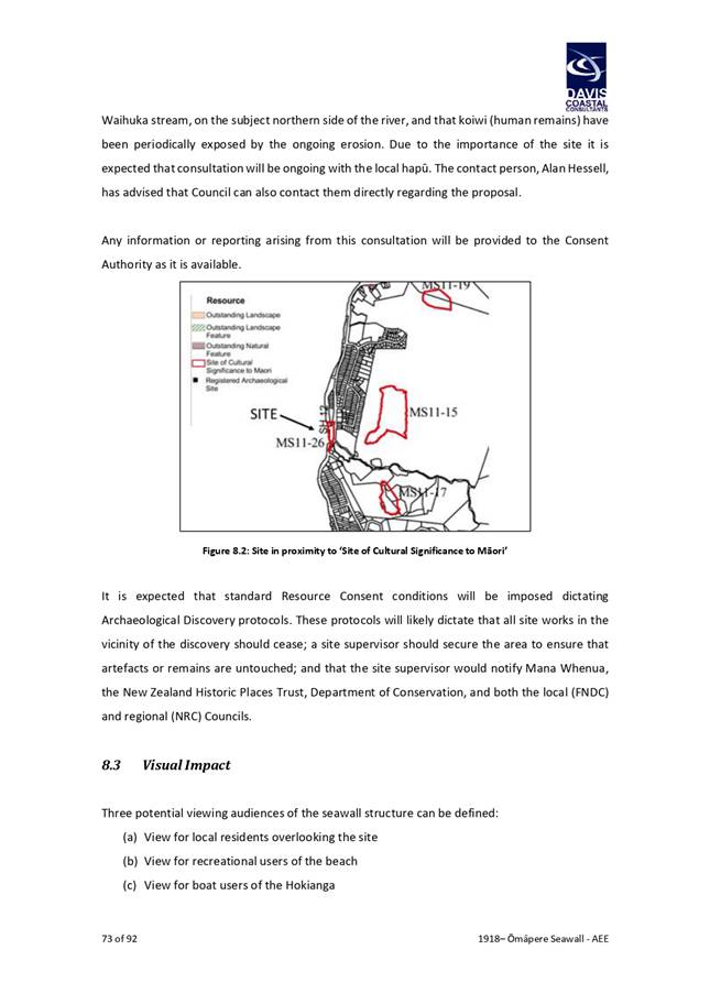
1977. The location of the proposed seawall in relation to the reserve land is
depicted in Figure 2 below. The seaward most reserve parcel has largely eroded
and now forms part of the active beach front dune face. The proposed seawall is
intended to be built along the seaward boundary of the second reserve parcel
(Lot 5 DP196729) for a distance of approximately 50m before angling towards the
southeast crossing into the boundary of the second reserve (Lot 2 DP91297).
This alignment generally follows the natural line of the dune toe.
The proposed structure is intended to terminate on the
seaward side of the reserve opposite 262 State Highway 12 to the north and 268
and 270 State Highway 12 to the south. These properties are privately owned.
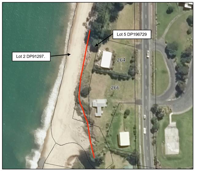
Figure 2. Reserve land affected by the proposed sea wall
structure. Approximate seawall extent and location shown in red.
·
It should be noted at this point that where reserve land owned by
a local authority is subject to erosion, any portion of the reserve that is
located seaward of the line of mean high water springs is divested from the
local authority in accordance with Section 11 of the Marine and Coastal Area
(Takutai Moana) Act 2011. Email correspondence from FNDC’s Property
Legalisation team to the applicant dated 5 August 2020 (included as Appendix E
of the application report) confirms the status of the reserve land, stating:
·
· Lot
2 DP 91297 (the seaward most parcel) is completely under water and is now part
of the Common Marine and Coastal Area.
· Lot
5 DP 196729 is partially under water and that portion is lost to the Common
Marine and Coastal Area and the title is divested for that portion of land now
below MHWS.
·
·
With the above taken into account, any portion of the reserve
parcels situated seaward of the dune toe are no longer owned by Council and it
is therefore only relevant to consider the effects of the proposed activity on
the portion of reserve located landward of the toe of the dune
cliff.
·
1.3) Coastal
setting
a)
The coastline in the vicinity of subject site
includes number of existing seawalls. Most recently Waka Kotahi completed
approximately 2km of erosion protection at various sections of the coastline to
the north of the subject sites through to Opononi. In addition, various
privately owned erosion protection structures are located to the immediate
south and north of the subject site. The approximate location and extent of
these structures is depicted in Figure 3 below.
Finally, it should be noted that a 115m long rock revetment
structure, similar to that which is the subject of this report, is proposed to
be constructed to protect Freese park from shoreline retreat. This is subject
to Council ratification and community consultation. The delivery
timeframe for that project is May 2022.
2) matapaki me NgĀ KŌwhiringa /
Discussion and Options
2.1) Matters
relevant to the decision
Coastal
processes
The resource consent application lodged with both FNDC
and NRC includes a comprehensive assessment of the coastal environment, and
detailed assessment of effects of the proposed activity on coastal processes,
including potential impacts on adjoining properties. A summary of technical
matters relevant to the determination requested by this report is provided in Attachment
2. Full details of the technical assessment can be found in the application
report attached as Attachment 1.
The technical assessment included with the resource
consent application has been prepared by a suitably qualified engineer
experienced in coastal engineering. The assessment demonstrates that the design
of the proposed structure is unlikely to result in any significant adverse
effects on coastal process. In particular, the assessment demonstrates that
erosion on either end of the structure is not anticipated and that the
structure has been designed to accommodate future sea level rise scenarios in
accordance with relevant Ministry for the Environment guidelines.
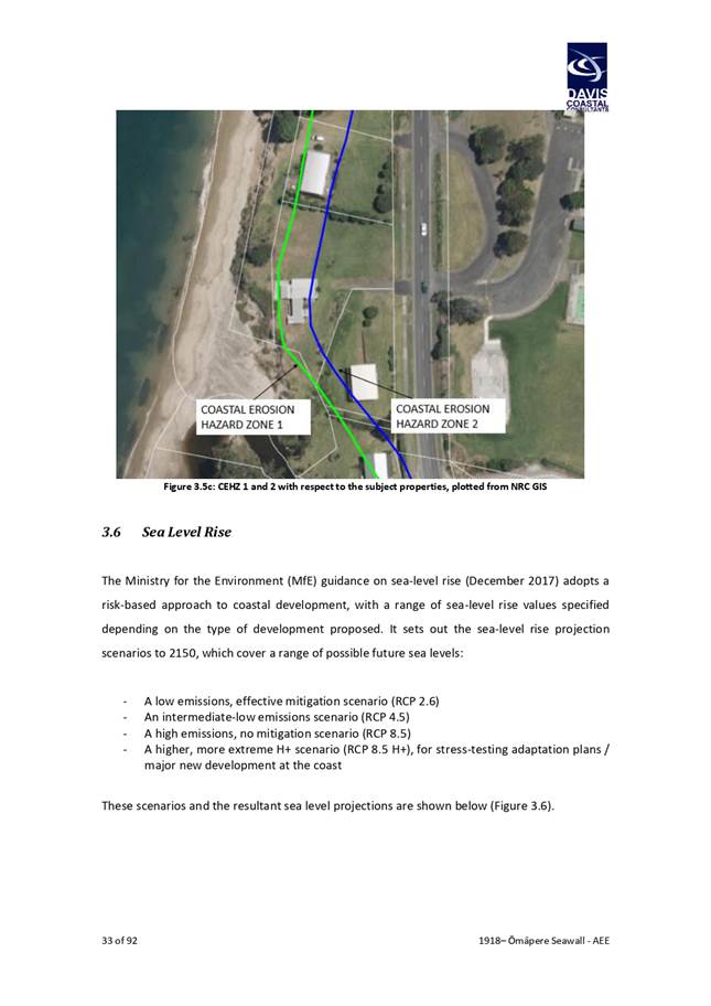
Coastal erosion hazard
Northland Regional Council has
analysed and mapped coastal erosion hazards around Northland to better
understand impacts into the future. The most up to date predicted future
shoreline positions were released in 2021[1].
These are shown in Figure 4 below in relation to the subject properties.
Coastal Erosion Hazard Zones contained in Figure 3
(CEHZ’s) are defined as follows:
· CEHZ1 – Predicted future shoreline at 2080 with a
66% probability of being exceeded.
· CEHZ2 – Predicted future shoreline at 2115 with
a 5% probability of being exceeded.
The erosion hazard mapping indicates that both
properties are likely to become significantly threatened within the next 50
years.
Resource consent requirements
The proposed erosion protection structure requires
resource consents from the Northland Regional Council. Earthworks associated
with the enabling works is also required by the Far North District Council and
the Northland Regional Council. Importantly, advice from the Northland Regional
Council is that, once the erosion protection structure has been constructed,
the resource consents for the structure will no longer be required because
consent is only required for construction, not ongoing occupation, and use.
That no consent is required for the ongoing use of the seawall means that the
owners of the asset will not be bound by any consent requirements, including
requirements for on-going maintenance, addressing any adverse effects that may
arise or removing the structure.
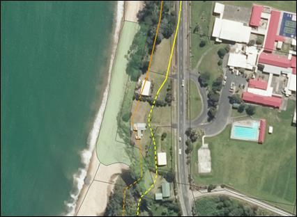
Access
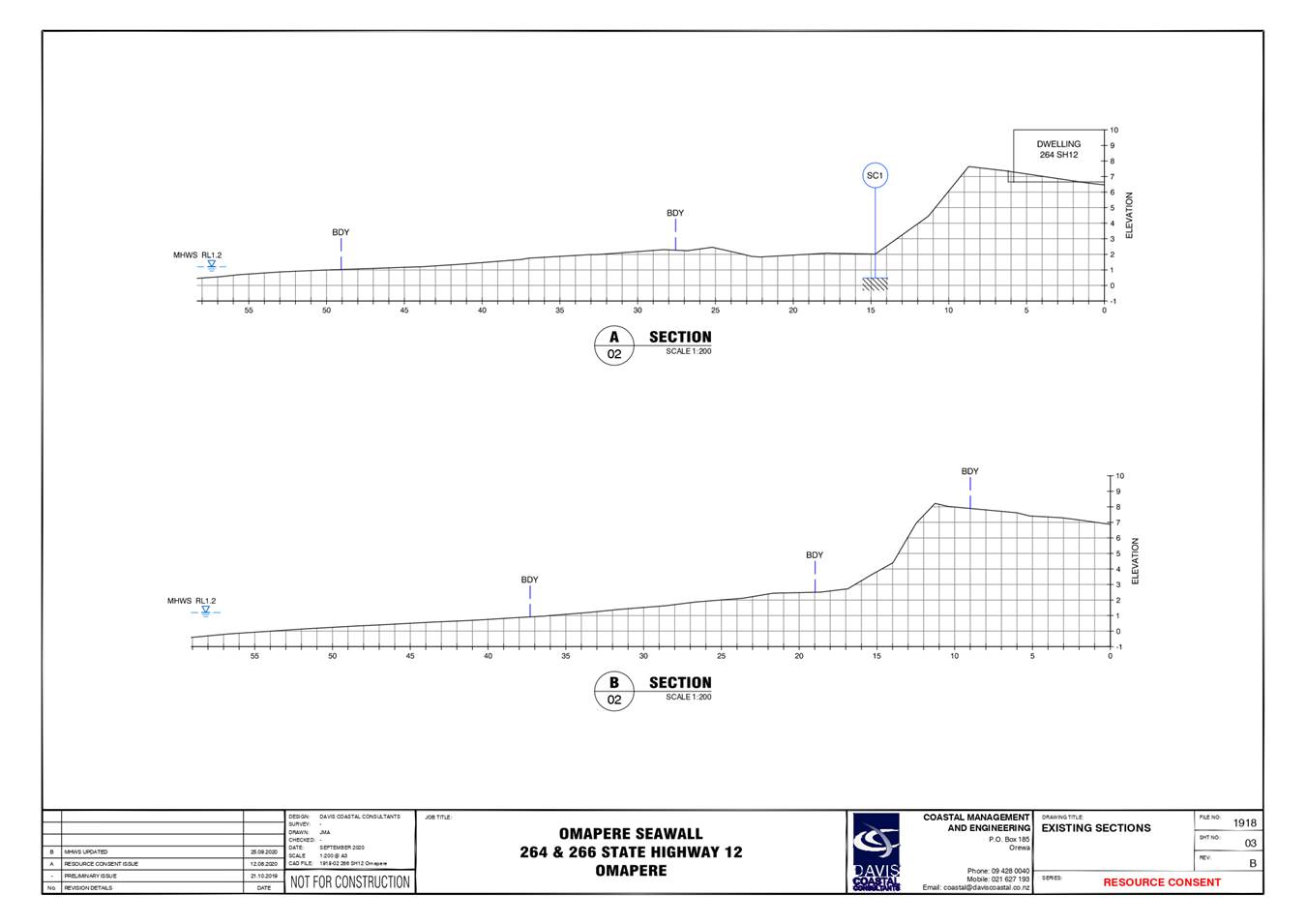
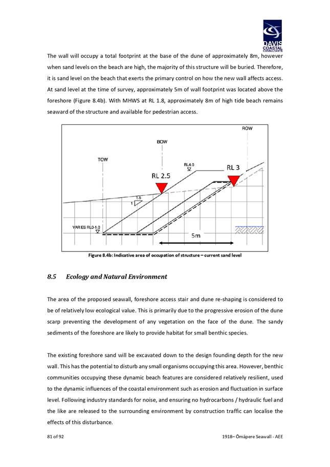
Access to the affected portion of the reserve will be
unaffected by the proposed erosion protection structure. The width of the
reserve is approximately 10m from the toe of the dune scarps to the landward
most boundary of the reserve. The proposed structure is to be located at the
toe of the dune scarp and so access to the reserve will be unchanged from the
current situation. Access to the beach from the reserve is presently not
possible as a result of the c.5m high dune scarp (Figures 5 and 6).
Reserves
Act 1977 requirements
Council is the administering body for the reserve. Section
40 of the Reserves Act 1977 charges the administering body with managing and
controlling reserves so as to ensure the use, enjoyment, development,
maintenance, protection, and preservation, as the case may require, for the
purpose for which it is classified.
The reserve is designated Local Purpose Reserve (Esplanade)
Reserve Under the Reserves Act 1977. The purpose of esplanade reserve is
further defined in the Resource Management Act 1991 as being:
· An esplanade reserve or an esplanade strip has 1 or
more of the following purposes:
(a) to
contribute to the protection of conservation values by, in particular, —
(i) maintaining
or enhancing the natural functioning of the adjacent sea, river, or lake; or
(ii) maintaining
or enhancing water quality; or
(iii) maintaining
or enhancing aquatic habitats; or
(iv) protecting the
natural values associated with the esplanade reserve or esplanade strip; or
(v) mitigating
natural hazards; or
(b) to enable
public access to or along any sea, river, or lake; or
(c) to enable
public recreational use of the esplanade reserve or esplanade strip and
adjacent sea, river, or lake, where the use is compatible with conservation
values.
Taking the above into account, it is considered that
granting permission to allow for the construction of an erosion protection
structure is generally in keeping with the purposes of esplanade reserves set
out in the RMA, and the broad responsibilities of administering bodies set out
in Section 40 of the Reserves Act 1977.
Relevant FNDC Policy
FNDC Reserves Policy
FNDC has a reserves policy dated March 2017. Section 4
of the Reserves Policy contains policies covering encroachments on Council
owned land. Policy 2 sets out that Council will decline all future requests for
private use of public land for access or occupation unless such use provides a
benefit to the proper use and enjoyment of the public land. It is worth noting
that the current reserve policy contains no policy direction or objectives that
consider climate change, sea level rise or coastal erosion and so the policy
direction it contains does not offer any substantive guidance in respect of the
situation that is the subject of this report; and it is unclear whether Policy
2 was drafted with the proposal that is the subject of this report in mind.
As discussed in the previous section it is considered
that granting approval of the proposal is generally in keeping with the
purposes of esplanade reserves set out in the RMA, and the broad responsibilities
of administering bodies set out in Section 40 of the Reserves Act 1977 because
it will enable the preservation and maintenance of the of the reserve. Given
the proposed seawall will have the effect of preserving the reserve through
protection from progressive shoreline retreat, it is considered that the
seawall is not inconsistent with Policy 2.
Draft Proposed Far North District Plan
It is relevant to note that the policy direction in
the Draft Proposed Far North District Plan seeks to discourage new development
within the CEHZ1 (50-year erosion hazard line), with most new development
within that zone requiring a discretionary resource consent. Although the plan
remains in draft and has not yet been notified, the policy direction provides indication
to Far North communities that development within the 50-year hazard zone is an
activity that is not encouraged from a land use planning
context.
Council’s liability for
an erosion protection structure on ‘Local Purpose Reserve’
As set out earlier in this report,
once the consent for the erosion protection structure has been exercised, the
consent holder will be able to surrender the resource consents and will not be
bound by any consenting requirements covering the on-going maintenance, removal
or addressing potential adverse effects associated with changes in coastal
processes. The lack of on-going resource consent could expose council to the
liability of addressing these issues given it will be located on council land.
Should the Council decide to grant
approval for the construction of the erosion protection structure on the
reserve, it is recommended that a memorandum of encumbrance is registered
against the record of titles of each of the applicants to formalise the
existence of the seawall. The encumbrance can require agreement to the
following conditions:
· Applicants’
responsible for the maintenance, repair, removal of the seawall (if required)
during its lifetime, and end of its lifetime
· Applicants’
to incur cost of the agreement construction and registration against title
· Applicant
to notify FNDC of any variation or modification of the seawall
It is considered that the above
conditions will adequately address any issues council being potentially liable
for the seawall and any associated effects on adjoining properties.
2.2) Consideration
of Alternatives
The assessment of environmental effects for the resource
consent application includes an assessment of alternatives options. These
alternatives are summarised below.
Do Nothing – Allow Retreat of the Coastline
The Assessment of Environmental Effects (AEE) report
identifies that the shoreline is progressively retreating and allowing the
coastline to continue to retreat would likely require the dwellings within each
property to be relocated to the CEHZ2 (2115) hazard line. The AEE report sets
out that this option is not considered to be practicable owing to the
progressive nature of the shoreline retreat and the fact that the owners would
be faced with the same issue in later years. This option was accordingly ruled
out.
‘Soft’ Protection Options
The AEE report includes an assessment of soft protection
options which include importing stand, planting, and installation of groynes to
assist with the retention of imported stand. To be effective, the groyne
structures would substantially impede access along the beach and would
potentially disrupt longshore sediment transport – potentially causing
unacceptable erosion at adjoining sites. Importing sand was identified as not
being practicable because the material would need to be located seaward of the
natural coastline position of the rest of the embayment and so would be subject
to potentially rapid erosion and transport to the wider beach system –
meaning that sand would need to continuously imported in order for it to
provide an effective means of erosion protection.
2.3) Options
Assessment
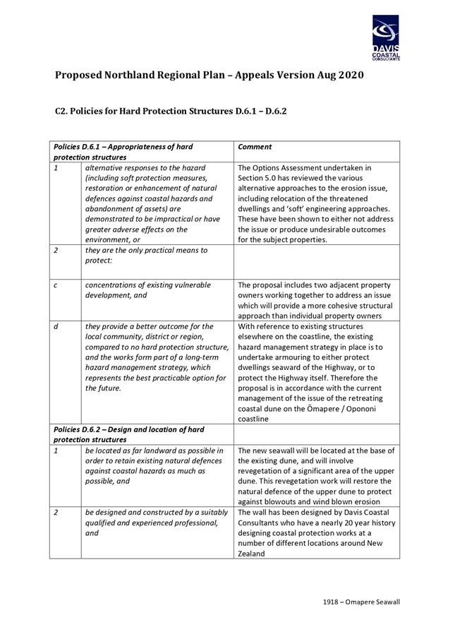
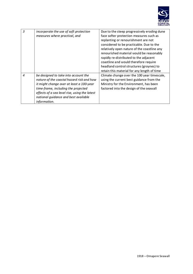
Option 1: Withhold written approval
It is unlikely the application would be able to proceed in
its current form without FNDC giving approval to occupy the reserve with the
seawall. Approval is required for the resource consent applications to proceed
without notification. However, the seawall cannot proceed without approval from
the administering body of the reserve because doing so would be inconsistent
with the legal requirements of the Reserves Act 1977.
In effect, this option would severely limit the ability for
the owners of the two properties fronting the FNDC reserve land to protect
their properties and dwellings from ongoing erosion of the coastal cliff.
Ultimately, this option will require that the landowners relocate the dwellings
given the current level of risk they are exposed to.
Option 2 (recommended option): Provide written approval
This option will allow the two properties to construct a
seawall at the toe of the remaining reserve land. This option will provide
protection of coastal erosion for at least a 50-year term with negligible
impact on the use of the existing reserve land. It is considered any liability
that council would be exposed to by virtue of it being the landowner on which
the structure is partially located can be suitably limited by way of a
memorandum of encumbrance placed on the titles of applicants’ properties.
Take
Tūtohunga / Reason for the recommendation
b)
Option 2 is the
recommended option for the following reasons:
· There is minimal council reserve remaining and that
which does remain has limited value as a local purpose reserve.
· The proposed structure will not affect access to or
from the reserve above those affects caused by the 5m high dune cliff.
· The application documentation provides a detailed
assessment of the proposal’s effect on coastal processes and demonstrates
with sufficient levels of certainty that the proposal is unlikely to exacerbate
coastal erosion processes and has been designed to accommodate sea level rise.
· The option will allow two properties to protect
existing dwellings that are at high risk of being affected by coastal erosion
in the near future and will allow other options to be implemented (e.g. managed
retreat) as the effects of sea level rise become more acute.
3) PĀnga PŪtea me ngĀ
wĀhanga tahua / Financial Implications and Budgetary Provision
All legal costs associated with the drafting interpretation
of the memorandum of encumbrance are to be borne by the owners of the
properties that have sought to construct the erosion protection structure on
Council owned reserve land. Given the encumbrance will place the responsibility
of the maintenance and eventual removal of the seawall on the owners of the
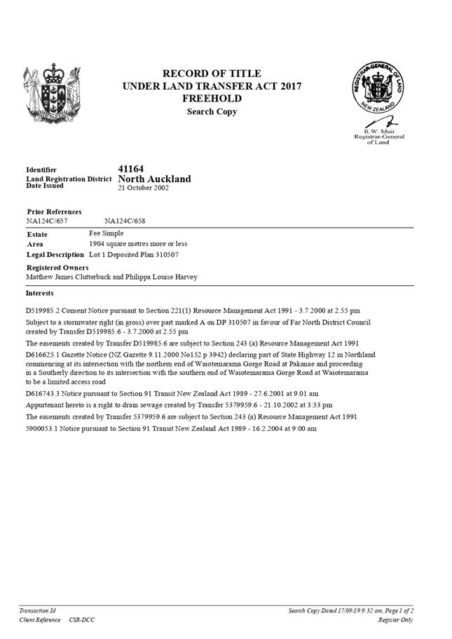
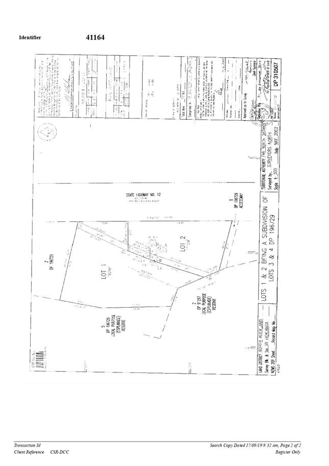
properties described as Lot 1 DP196729 and Lot 1 DP310507, it is not expected
the recommended resolution will carry any ongoing financial implications
Āpitihanga
/ Attachments
1. Proposed
Omapere Seawall Assessment of Environmental Effects - A3184151 ⇩ 
2. Proposed
Omapere Seawall - Summary of relevant techincal matters - A3184158 ⇩
Hōtaka Take Ōkawa / Compliance Schedule:
Full consideration has been given
to the provisions of the Local Government Act 2002 S77 in relation to decision
making, in particular:
1. A
Local authority must, in the course of the decision-making process,
a) Seek to
identify all reasonably practicable options for the achievement of the
objective of a decision; and
b) Assess
the options in terms of their advantages and disadvantages; and
c) If any
of the options identified under paragraph (a) involves a significant decision
in relation to land or a body of water, take into account the relationship of
Māori and their culture and traditions with their ancestral land, water
sites, waahi tapu, valued flora and fauna and other taonga.
2. This
section is subject to Section 79 - Compliance with procedures in relation to
decisions.
|
He Take Ōkawa / Compliance Requirement
|
Aromatawai Kaimahi / Staff Assessment
|
|
State the level
of significance (high or low) of the issue or proposal as determined by the Council’s
Significance and Engagement Policy
|
It is not
considered that the recommended resolution tiggers the thresholds in any of
the criteria set out in the current significance and engagement policy.
|
|
State the
relevant Council policies (external or internal), legislation, and/or
community outcomes (as stated in the LTP) that relate to this decision.
|
The relevant
legislation is the Reserves Act 1977. The relevant policy is Councils
Reserves Policy, dated 16 March 2017. The implications of the recommended
resolution in respect of the provisions of the Reserves Act and the Reserves
Policy are discussed in the body of the report.
|
|
State whether
this issue or proposal has a District wide relevance and, if not, the ways in
which the appropriate Community Board’s views have been sought.
|
The proposal
that is the subject of this report does not affect the district as a whole.
Whilst the topic of climate change and its impact on coastal erosion is of
relevant to the district, that is not a topic that is appropriate to broach
as part of this report.
|
|
State the possible implications for
Māori and how Māori have been provided with an opportunity to
contribute to decision making if this decision is significant and relates to
land and/or any body of water.
|
The views of
mana whenua have not been sought. The applicant has consulted with mana
whenua as part of the consent application and the outcome of that
consultation is reported in is the AEE report attached as Attachment 1.
|
|
Identify
persons likely to be affected by or have an interest in the matter, and how
you have given consideration to their views or preferences (for example
– youth, the aged and those with disabilities).
|
Taking into account
the conclusions of the technical assessment contained with the AEE report
(Attachment 1), it is considered that no persons are likely to be affected by
the proposal.
|
|
State the
financial implications and where budgetary provisions have been made to
support this decision.
|
Refer to
Section 3 of this report.
|
|
Chief Financial
Officer review.
|
The Chief
Financial Officer has reviewed this report.
|
|
Kaikohe-Hokianga
Community Board Meeting Agenda
|
2 June 2021
|

Attachment
2: Summary of relevant technical matters contained within the Assessment of
Environmental Effects
The
resource consent application for the proposed erosion protection
structure is supported by a detailed technical assessment of the effects
of the proposed seawall on coastal processes. A summary of technical matters
relevant to the consideration of Council approval is given below.
Storm
effects
The
seawall has been designed with 1.8m freeboard above current 1% AEP storm tide
levels and includes engineered design elements to reduce the risk of large
scale erosion of dune sands behind the proposed wall. Foundation undermining is
proposed to be prevented by excavating the wall 500mm into underlying harder
base material. This allows for the entire loss of the existing beach in front
of the structure (approximately 1.5m deep at the time of application), and
lowering of 500mm of the underlying material, before the seawall is at risk of
undermining.
End
erosion
End
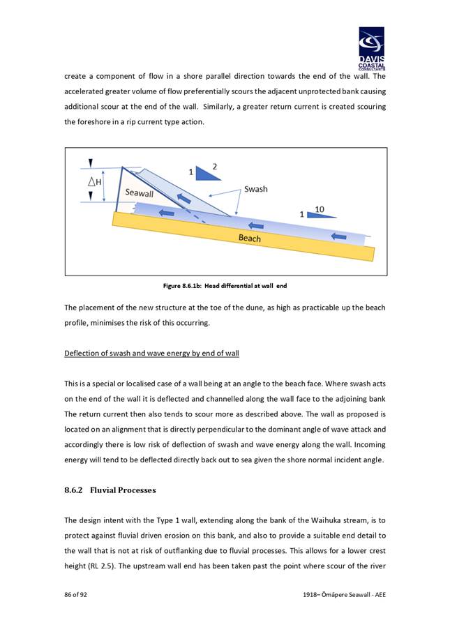
erosion can occur as a result of wave or current differentials created by a
hard protection structure transferring energy to unprotected portions of the
dune or beach. The application report has provided a detailed assessment of the
potential effects of end erosion associated with the proposed structure that
take into account the detailed analysis of the wave environment, historic
extreme water levels, sediment transport mechanisms and the existing foreshore
environment. The application report sets out that the wall as proposed to be
located on an alignment that is directly perpendicular to the dominant angle of
wave attack and accordingly there is low risk of deflection of swash and wave
energy along the wall. Incoming energy will tend to be deflected directly back
out to sea given the shore normal incident angle. The applicant also proposes
to bed the northern end of the wall 4m into the dune face at an angle of
90° into the backing. This will provide futureproofing for the end portion
of the wall against future retreat of the coastline. This embedment can be
increased as the coastline continues to retreat and imposing requirements of
that nature though conditions of consent would be within the ambit of the
consent authority.
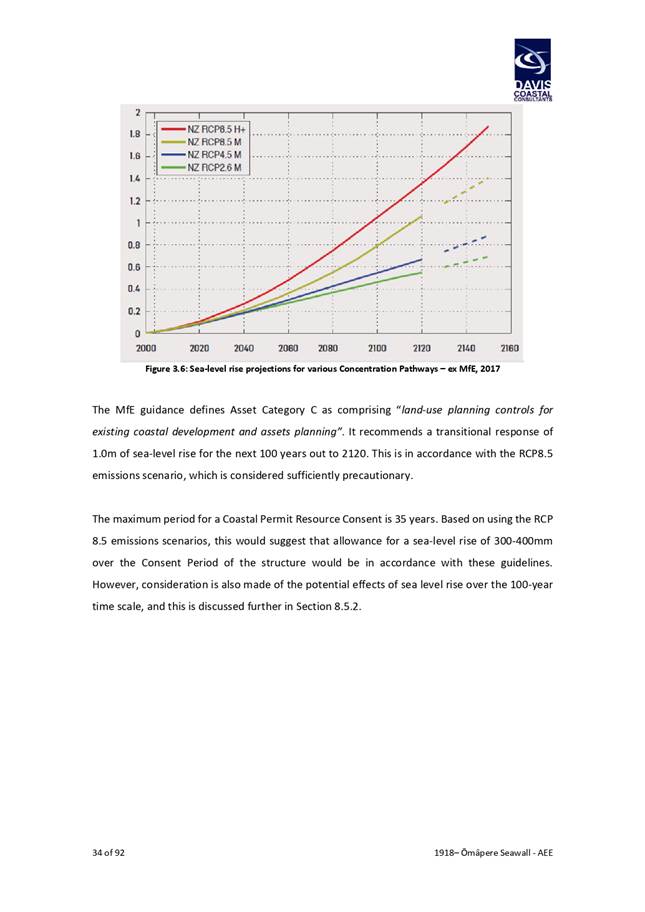
Sea
level rise
The
application report provides an assessment of the proposal taking into account a
sea level scenario based on the RCP 8.5 emissions scenario (i.e. the worst case
scenario) in accordance with MfE Guidelines[2].
Based on the RCP 8.5 emissions scenarios, those guidelines indicate a sea-level
rise of 300-400mm over the next 35 years and a sea level rise of 1m within the
next 100 years. The applicant has sought a term of 35 years for the coastal
permit authorising the occupation of the structure within the common marine and
coastal area. A 35 year assessment period is therefore appropriate.
The application report demonstrates that, for current
predictions of sea-level rise over the 35 year consent term, the structure
remains resilient to the extreme water level events, including wave setup. It
should be noted that the report also demonstrates that the structure will be
unaffected by 1% AEP storm tides up to the 1m sea level rise scenario.
6.2 Kaikohe-Hokianga
Footpath Programme
File
Number: A3201345
Author: Sandi
Morris, Road Safety and Traffic Planning Engineer
Authoriser: Andy
Finch, General Manager - Infrastructure and Asset Management
Take Pūrongo / Purpose of the Report
To seek approval for the 2021/2022-year footpath programme
for the Kaikohe-Hokianga Community Ward.
WhakarĀpopoto matua / Executive Summary
· There is
a total of $150,000 available for New Footpath in the Kaikohe-Hokianga
Community Ward.
· An additional
$320,000 has been proposed to Waka Kotahi New Zealand Transport Agency (NZTA)
for new footpath projects from the 2021/2022 financial year at the revised
Financial Assistance Rate of 69%.
· Waka
Kotahi requires footpaths to have a strong emphasis on safety and accessibility
so new measures have been introduced into the ‘footpath matrix’.
· Due to
recent impacts on Central Government budgets, the previous funding allocations
from the ‘Low Cost Low Risk Activity Class, is unlikely to be accepted
for the 2021/2022 financial year. The outcome of this funding allocation may
not be known until September 2021.
|
tŪtohunga
/ Recommendation
That the Kaikohe-Hokianga Community Ward.:
a) Agree
to the 2021/2022 footpath programme to include the following ‘top nine’
prioritised and subject to funding availability:
i) Parnell
Street Rawene - Hospital to Clendon Esplanade (Est $500,000)
ii) Manning
Street Rawene - Existing to House #54 Manning Street (Est $70,000)
iii) Koutu
Point Road Koutu - SH12 to 68 Koutu Point Road (Est $340,000)
iv) Old
Wharf Road Omapere - SH12 to Wharf (Est $40,000)
v) Freese
Park Road Omapere – Old Wharf Road to end (Est $40,000)
vi) Horeke
Road Okaihau - Existing to house 2054 (Est $230,000)
vii) Honey Street
– Parnell Street to End (Est $120,000)
viii) Taumataiwi Street
Opononi – Walkway to SH10 - via bowling green (Est $30,000)
ix) Michie
Street – Start to Playschool (Est $30,000)
b) Identify
and recommend to Council a list of footpaths from the above priority safety
programme to the values of $150,000 to be constructed 100% funded from Far
North District Council Funds.
|
1) TĀhuhu kŌrero / Background
NZTA
Footpath Funding
Government, through the Ministry of Transport, published the
Road to Zero strategy for 2020-2030 and the initial 3-year implementation plan
in December 2019, prior to the COVID pandemic.
The Road to Zero strategy prioritises funding commitments
for its transport vision, and ‘new footpaths’ were placed at number
4 on a list of 15 strategic priorities for funding to ‘Enhance safety and
accessibility of footpaths, bike lanes and cycleways’.
Due to the global pandemic, some funding prioritises have
been reorganised to enhance general road safety with more stringent guidelines.
The outcome of any funding changes will not be realised
until August/September 2021.
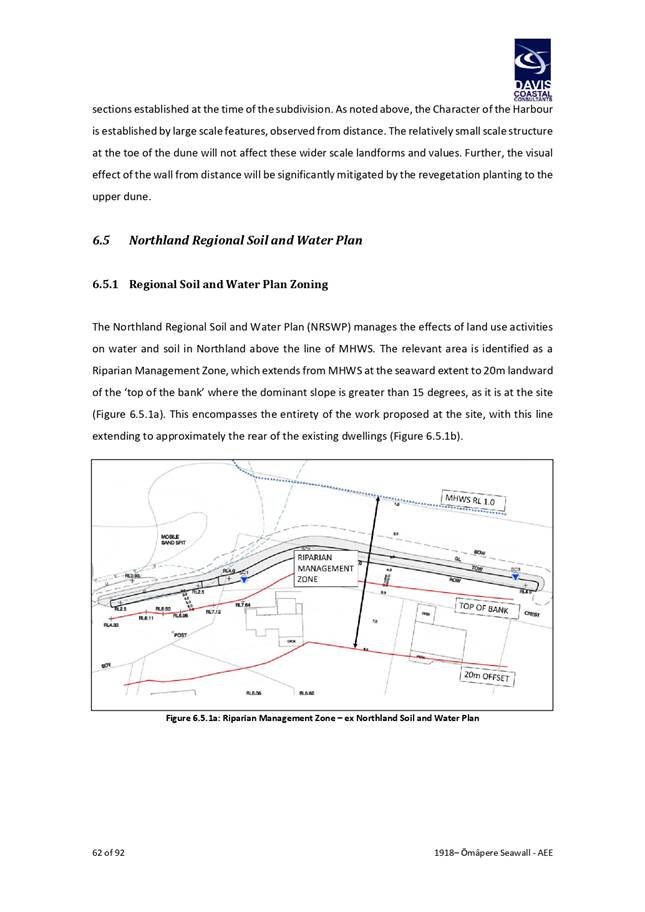
Kaikohe-Hokianga Community – Footpath Matrix
Amendments
While the former footpath matrix methodology was accepted by
Waka Kotahi NZTA, under the new central government strategy additional safety
and accessibility measures have been added. The new matrix attributes are now
as follows:
· School (within certain distance)
· Tourist Route
· Berm Space
· Existing Footpath
· Existing Link
· Trip Generation
· NEW - Posted and Operated Speed Limit
o Posted = Roadside signs/Legal Speed Limit
o Operating = the speed at which drivers operate the vehicle
· NEW - One Network Framework (ONF)
o The ONRF is the national classification system. It is used to
determine the function of our roads and streets, and to inform decision making.
· NEW - Crash Analysis System (CAS)
o CAS is a data collection system which provides tools to analyse and
map crashes and enables users to identify high risk locations and monitor
trends and crash sites. The source data is gathered from NZ Police crash
reports.
· NEW - Annual Average Daily Traffic (AADT)
o AADT is a measure used primarily in transportation planning,
engineering and retail location. It is the total volume of vehicle traffic of a
highway or road for a year divided by 365.
These new measures have now been accepted by
Waka Kotahi NZTA.
2) matapaki me NgĀ KŌwhiringa /
Discussion and Options
There is a total of $150,000
available for New Footpaths in the Kaikohe-Hokianga Community Ward. This is
allocated by Far North District and is 100% funded from Far North District
funds.
An additional $320,000 per annum,
has been proposed to Waka Kotahi New Zealand Transport Agency for new footpath
projects from the 2021/2022 to 2023/2024 financial years (3-year programme).
The annual programme should attract the revised financial assistance rate (FAR)
of 69%.
While the former footpath matrix
methodology was accepted by Waka Kotahi New Zealand Transport Agency, under the
new central government strategy additional safety and accessibility measure
have been added. The new matrix attributes are now as follows:
· School
(within certain distance)
· Tourist
Route
· Berm
Space
· Existing
Footpath
· Existing
Link
· Trip
Generation
· NEW
– Posted and Operating Speed Limit
o Posted
= Roadside signs/Legal speed limit
o Operating
= the speed at which drivers operate the vehicle (where available)
· NEW
– One Network Framework (ONF)
o The
ONF is the national classification system. It is used to determine the function
of our roads and streets, and to inform decision making.
· NEW
– Crash Analysis System (CAS)
o CAS is
a data collection system which provides tools to analyse and map crashes and
enables users to identify high risk locations and monitor trends and crash
sites. The source data is gathered from NZ Police crash reports. A copy of the
· NEW
– Annual Average Daily Traffic (AADT)
o AADT
is a measure used primarily in transportation planning, engineering and retail
locality. It is the total volume of vehicle traffic of a highway or road for a year
divided by 365.
The new attributes have been
accepted by Waka Kotahi NZTA and now been placed into the footpath matrix to
further analyse the highest ranked footpaths to be delivered across Far North
District.
It is important to note that CAS data has been explored to highlight where the
Far North District are experiencing the greatest pedestrian risk. NTA staff
analysed data from 2010-2021 for all crashes involving a pedestrian, the
results are shown in the below heat map:
Due to early notification of potential funding shortfall
from Waka Kotahi NZTA, other programmes are being explored to deliver
pedestrian improvement programmes. These could be raised pedestrian platforms
and speed tables, delivered through Waka Kotahi NZTA’s new activity class
of ‘Road to Zero – Safety Network Programme’.
Take
Tūtohunga / Reason for the recommendation
It is recommended that the
Kaikohe-Hokianga Community Ward agrees that the Northland Transport Alliance
for Far North District implement footpaths as prioritised in the ‘top
9’ from the footpath matrix, (budget $320,000) as follows:
1. Parnell Street Rawene - Hospital to Clendon
Esplanade (Est $500,000)
2. Manning Street Rawene - Existing to House #54
Manning Street (Est $70,000)
3. Koutu Point Road Koutu - SH12 to 68 Koutu
Point Road (Est $340,000)
4. Old Wharf Road Omapere - SH12 to Wharf (Est
$40,000)
5. Freese Park Road Omapere – Old Wharf
Road to end (Est $40,000)
6. Horeke Road Okaihau - Existing to house 2054
(Est $230,000)
7. Honey Street – Parnell Street to End
(Est $120,000)
8. Taumataiwi Street Opononi – Walkway to
SH10 - via bowling green (Est $30,000)
9. Michie Street – Start to Playschool (Est
$30,000)
These new footpaths are proposed
as funding from Waka Kotahi NZTA is made available, with a FAR of 69%. The
order in which they are delivered will be determined by the available fund for
each financial year.
Kaikohe-Hokianga Community Ward
will still need to identify a list of footpaths for delivery for 2021/2022
financial year, to be constructed from Far North District Council funds (100%).
The Community Ward could opt to prioritise from the ‘top nine’
proposed new footpaths or nominate another ‘new footpath’ for
consideration (budget $150,000).
3) PĀnga PŪtea me ngĀ
wĀhanga tahua / Financial Implications and Budgetary Provision
There is a total of $150,000
available for New Footpaths in the Kaikohe-Hokianga Community Ward. This is
allocated by Far North District and is 100% funded from Far North District
funds.
An additional $320,000 per annum,
has been proposed to Waka Kotahi New Zealand Transport Agency for new footpath
projects from the 2021/2022 to 2023/2024 financial years (3-year programme).
The annual programme should attract the revised financial assistance rate (FAR)
of 69%.
Āpitihanga
/ Attachments
Nil
Hōtaka Take Ōkawa / Compliance Schedule:
Full consideration has been given to the provisions of the
Local Government Act 2002 S77 in relation to decision making, in particular:
1. A
Local authority must, in the course of the decision-making process,
a) Seek
to identify all reasonably practicable options for the achievement of the
objective of a decision; and
b) Assess
the options in terms of their advantages and disadvantages; and
c) If
any of the options identified under paragraph (a) involves a significant
decision in relation to land or a body of water, take into account the
relationship of Māori and their culture and traditions with their
ancestral land, water sites, waahi tapu, valued flora and fauna and other taonga.
2. This
section is subject to Section 79 - Compliance with procedures in relation to
decisions.
|
He Take Ōkawa / Compliance Requirement
|
Aromatawai
Kaimahi / Staff Assessment
|
|
State the level of significance
(high or low) of the issue or proposal as determined by the Council’s
Significance and Engagement Policy
|
This is a
footpath programme and is of low significance.
|
|
State the relevant Council
policies (external or internal), legislation, and/or community outcomes (as
stated in the LTP) that relate to this decision.
|
Land Transport Act, National Policy Statement, NZ Standards 4404,
Policy #5004 Footpaths
|
|
State whether this issue or
proposal has a District wide relevance and, if not, the ways in which the
appropriate Community Board’s views have been sought.
|
There is limited
district wide relevance; footpaths are a public asset. The Community Board
have the delegated authority to approve footpath priorities.
|
|
State the possible implications for Māori
and how Māori have been provided with an opportunity to contribute to
decision making if this decision is significant and relates to land and/or
any body of water.
|
Not applicable.
|
|
Identify persons likely to be
affected by or have an interest in the matter, and how you have given
consideration to their views or preferences (for example – youth, the
aged and those with disabilities).
|
Footpath
standards include provision for design for elderly and disabled. Communities
are in support of footpaths being built to current standard.
|
|
State the financial implications
and where budgetary provisions have been made to support this decision.
|
Footpaths are subsidised by Waka Kotahi
NZTA with a financial assistance rate of 69%. FNDC has planned for $320,000
to be funded by Waka Kotahi NZTA. The application is awaiting approval.
The Community
Ward influences 100% of Far North District Rate Payer funds up to $150,000
for footpaths.
|
|
Chief Financial Officer review.
|
The Chief Financial Officer has
reviewed this report
|
6.3 Kaikohe-Hokianga
Statement of Community Board Fund Account as at 30 April 2021
File
Number: A3190706
Author: Ajay
Kumar, Management Accountant
Authoriser: Janice
Smith, Chief Financial Officer
Purpose of the Report
The Community Fund account provides
information on financial matters relating to the Kaikohe-Hokianga Community
Board’s Community Fund which is allocated in accordance with the
Community Grant Fund Policy.
|
Recommendation
That the Kaikohe-Hokianga Community Board receives the
report Kaikohe-Hokianga Statement of Community Board Fund Account as at 30
April 2021.
|
Background
The statement is attached for the Board’s information
and to provide sufficient information to enable the Board to allocate funds in
accordance with the funds available.
|
Community Fund Account
balance as at 1 July 2020
|
$115,902.00
|
|
· Plus,
uncommitted funds from 2019-20 carried forward
|
$40,545.99
|
|
· Plus, Unspent
from 2018/19 - Matihetihe School support children participating in regular
sporting activity during 2019 winter season
|
$85.00
|
|
· Plus, Unspent
from 2018/19 - Rawene Golf Club Inc. to assist with the cost of The Hokianga
Golf Fun Day 2019
|
$115.79
|
|
· Plus, Unspent
from 2019/20 - Kaikohe Community & Youth Centre Trust for installation of
the basketball court and hoops at Memorial Park
|
$21,019.01
|
|
· Plus,
Commitments from 28/06/17 meeting towards Junior Bike Park
|
$14,376.54
|
|
· Less funds
granted and uplifted to 30 April 2021
|
$107,893.00
|
|
· Less funds
not uplifted from 09 December 2020 for Kaikohe Business Association
|
$4,750.00
|
|
· Less funds
not uplifted from 03 February 2021 for North Harbour A&P Society
|
$3,720.00
|
|
Community Fund Account balance as at 30 April 2021
|
$75,681.33
|
Discussion and Next Steps
Board members will consider the applications
on the agenda and decide on what level of funding to allocate. The
uncommitted balance in the Community Fund account as at 30 April 2021 is
$75,681.33.
Recent amendments to the Community
Grant Fund Policy allow the Community Board to allocate, by resolution, funding
directly to key projects identified in their strategic plan to the maximum
amount of $20,000 in any financial year.
Financial Implications and Budgetary Provision
The Far North District Council has delegated the allocation
of relevant community board funds to the Kaikohe-Hokianga 30 April 2021 is
attached.
Attachments
1. Statement
of Kaikohe-Hokianga Community Board Fund Account as at 30 April 2021 - A3190704
⇩ 
|
Kaikohe-Hokianga
Community Board Meeting Agenda
|
2 June 2021
|
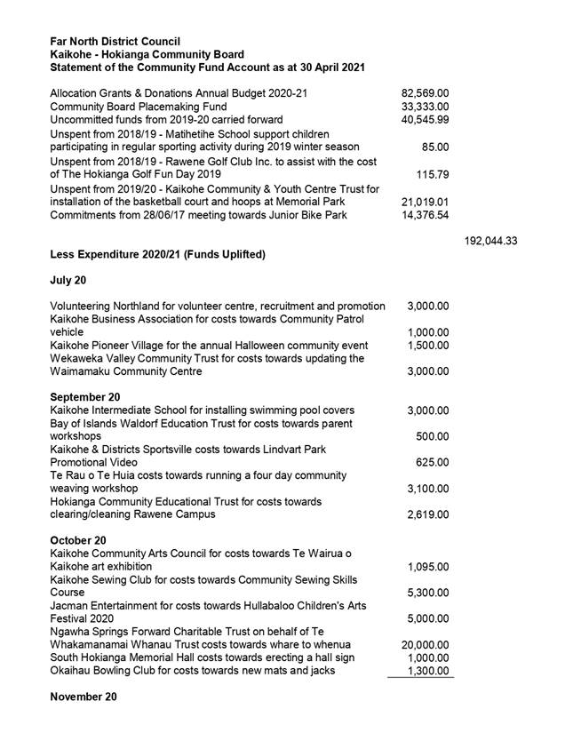
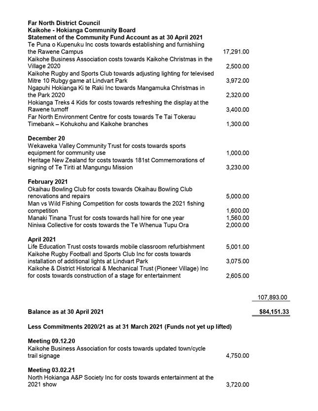
6.4 Funding
Applications
File
Number: A3188304
Author: Kathryn
Trewin, Funding Advisor
Authoriser: Ana
Mules, Team Leader - Community Development and Investment
Take Pūrongo / Purpose of the Report
This report summarises applications for Local Community
Grant funding to enable the Kaikohe-Hokianga Community Board to determine which
application/s will receive funding at the 12 May 2021 meeting.
WhakarĀpopoto matua / Executive Summary
· The
Kaikohe-Hokianga Community Board has $19,331.78 unallocated funding available
for the 2020/21 financial year.
· Two new
applications for funding have been received, requesting $8128
|
tŪtohunga
/ Recommendation
a) 6.4a) That the Kaikohe-Hokianga Community
Board approves the sum of $4928 (plus
GST if applicable) be paid from the Board’s Community Fund account to Bay
of Islands Canine Association for costs towards community dog education
and training to support the following Community Outcomes:
i) Communities
that are healthy, safe, connected and sustainable
ii) Proud,
vibrant communities
tŪtohunga / Recommendation
b) 6.4b)
That the Kaikohe-Hokianga Community Board approves the
sum of $3200 (plus GST if applicable) be paid
from the Board’s Community Fund account to Kaikohe and Districts
Sportsville for costs towards a bike track feasibility study to support
the following Community Outcomes:
i) Communities
that are healthy, safe, connected and sustainable
ii) Proud,
vibrant communities
|
|
Kaikohe-Hokianga
Community Board Meeting Agenda
|
2 June
2021
|
1)
TĀhuhu kŌrero / Background
Each application has been checked by staff for completeness
and complies with the conditions of the Community Grant Policy, Community
Outcomes as stated in the LTP and all provisions listed on the application
form.
2) matapaki me NgĀ KŌwhiringa /
Discussion and Options
|
Applicant
|
Project
|
Requested
|
Recommended
|
Comments
|
Community
Outcome(s)
|
Type
|
|
a) Bay of Islands Canine Association
|
Community dog-training
and education
|
$4928
50%
|
$4928
50%
|
This is the second year
that the association have come to the Board for funding, with a duplicate
application going to Bay of Islands-Whangaroa Board. As they have funds
remaining ($550), they have not provided a project report form, but have
indicated that the classes they have run have been well-attended and
supported.
|
i) Communities that are healthy, safe,
connected and sustainable
ii) Proud, vibrant communities
|
Community Development
|
|
b) Kaikohe and Districts Sportsville
|
Bike track feasibility
study
|
$3200
50%
|
$3200
50%
|
Sportsville are working
with Ākau Design and the NZ Police on the possibility of developing a
moto-x track in the Kaikohe area as part of a larger picture with the Cycle
Trail, a learner’s bike trail and a pump/BMX track. This would
benefit the community by getting bikes (including motorbikes) off the streets
and into a purpose-built area.
|
i) Communities that are healthy, safe,
connected and sustainable
ii) Proud, vibrant communities
|
Infrastructure
|
|
Kaikohe-Hokianga
Community Board Meeting Agenda
|
2 June 2021
|
Take Tūtohunga / Reason for the
recommendation
The applicant was required to complete a standard
application form and provide supporting information.
For each
application, the Board has three options.
Option 1 Authorise
funding for the full amount requested
Option 2 Authorise
partial funding
Option 3 Decline
funding
Each
application has been assessed and meets the criteria of the Community Grant
Policy, Community Outcomes as listed in the LTP, and the conditions listed on
the application form.
3) PĀnga PŪtea me ngĀ
wĀhanga tahua / Financial Implications and Budgetary Provision
Budgetary Provision has been made and the grant is allocated
in accordance with the Community Grant Policy
Āpitihanga
/ Attachments
1. Pages
from KHCB - Application - Bay of Islands Canine Association - A3200899 ⇩
2. Pages
from KHCB - Application - Kaikohe and Districts Sportsville Inc - A3200900 ⇩
Hōtaka Take Ōkawa / Compliance Schedule:
Full consideration has been given to the provisions of the
Local Government Act 2002 S77 in relation to decision making, in particular:
1. A
Local authority must, in the course of the decision-making process,
a) Seek
to identify all reasonably practicable options for the achievement of the
objective of a decision; and
b) Assess
the options in terms of their advantages and disadvantages; and
c) If
any of the options identified under paragraph (a) involves a significant
decision in relation to land or a body of water, take into account the
relationship of Māori and their culture and traditions with their
ancestral land, water sites, waahi tapu, valued flora and fauna and other
taonga.
2. This
section is subject to Section 79 - Compliance with procedures in relation to
decisions.
|
He
Take Ōkawa / Compliance Requirement
|
Aromatawai
Kaimahi / Staff Assessment
|
|
State the level of significance
(high or low) of the issue or proposal as determined by the Council’s
Significance and Engagement Policy
|
This is a matter of low
significance.
|
|
State the relevant Council
policies (external or internal), legislation, and/or community outcomes (as
stated in the LTP) that relate to this decision.
|
Community Grant Policy.
|
|
State whether this issue or
proposal has a District wide relevance and, if not, the ways in which the
appropriate Community Board’s views have been sought.
|
This report does not have
district-wide relevance.
|
|
State the possible implications for Māori
and how Māori have been provided with an opportunity to contribute to
decision making if this decision is significant and relates to land and/or
any body of water.
|
No implications for Māori in
relation to land and/or water.
|
|
Identify persons likely to be
affected by or have an interest in the matter, and how you have given
consideration to their views or preferences (for example – youth, the
aged and those with disabilities).
|
Considered in the application.
|
|
State the financial implications
and where budgetary provisions have been made to support this decision.
|
Budgetary Provision has been made
and the grant is allocated in accordance with the Community Grant Policy.
|
|
Chief Financial Officer review.
|
The Chief Financial Officer has
not reviewed this report.
|
|
Kaikohe-Hokianga
Community Board Meeting Agenda
|
2 June 2021
|
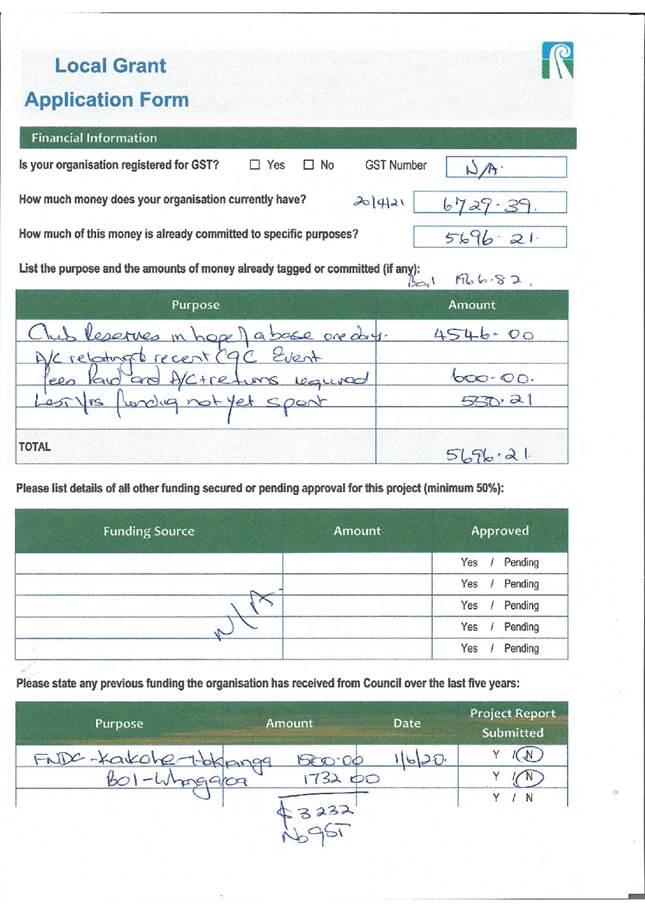
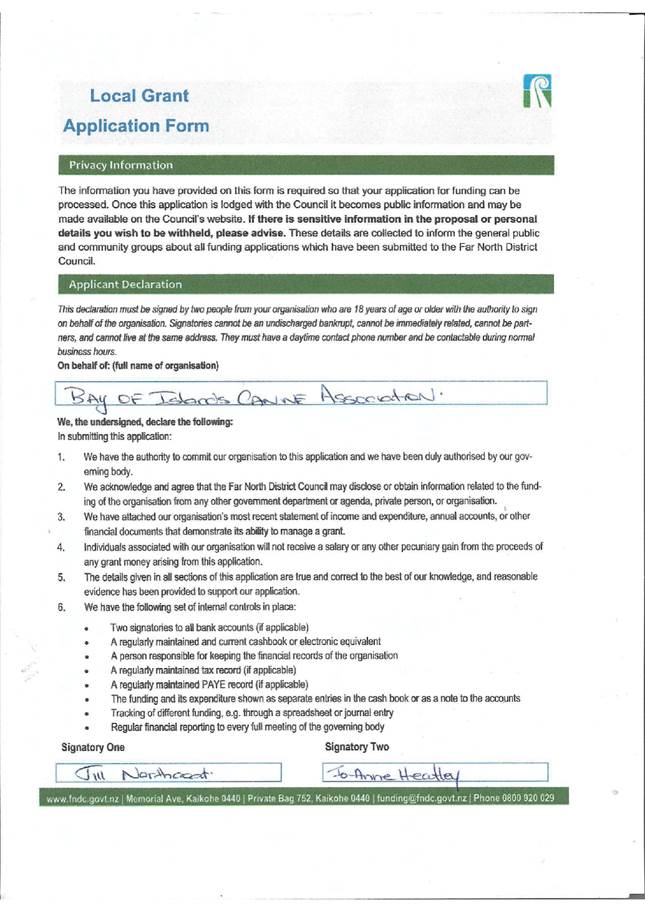
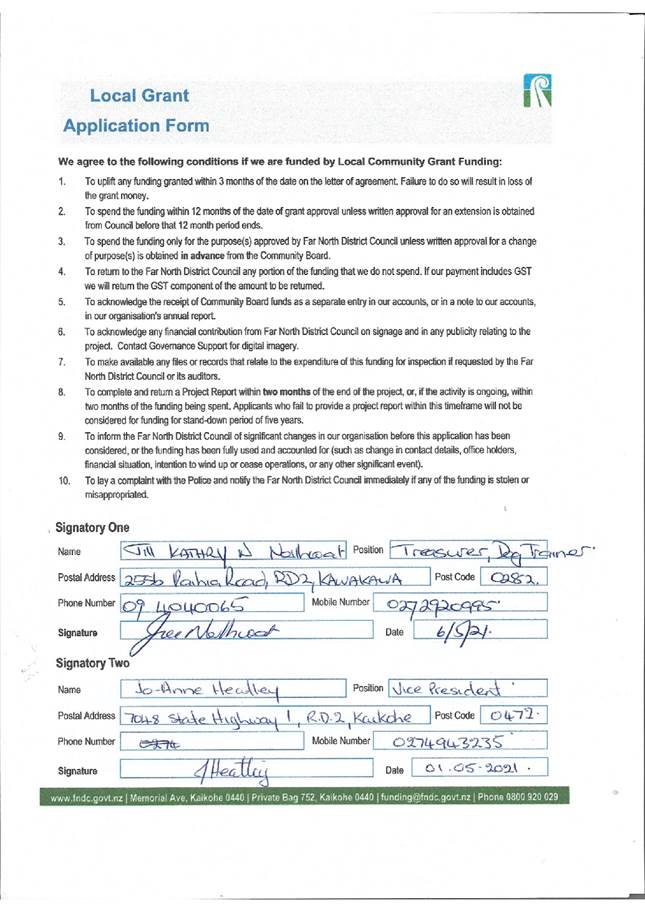
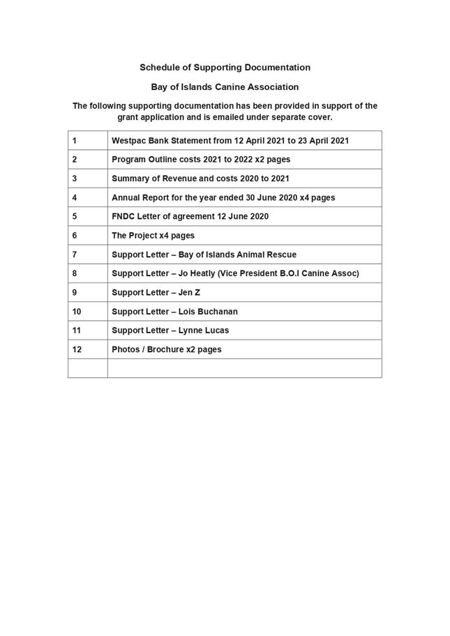
|
Kaikohe-Hokianga
Community Board Meeting Agenda
|
2 June 2021
|
7 Information
Reports
7.1 Update
on Speed Limit Bylaw Review
File
Number: A3177116
Author: Roger
Ackers, Manager - Strategy Development
Authoriser: William
J Taylor MBE, General Manager - Strategic Planning and Policy (Acting)
TAKE PŪRONGO / Purpose of the Report
To update the Kaikohe and
Hokianga Community Board on the Speed Limit Review Programme, including the
review process and upcoming consultations.
WHAKARĀPOPOTO MATUA / Executive SummarY
The purpose of this item is to
provide the Community Board with background to the ongoing speed review
programme. The paper also includes an overview of the current speed review
programme, prioritisation, and review process. The item also provides
information on upcoming consultation and how the Board can provide input into
that process.
The rolling review of all
speed limits in Far North District is being undertaken as part of the
implementation of the National Road Safety Strategy: Road to Zero: A Road
Safety Strategy for New Zealand 2020-2030.
|
TŪTOHUNGA
/ Recommendation
That the Kaikohe-Hokianga Community Board receive the
report Update on Speed Limit Bylaw Review.
|
tĀHUHU KŌRERO / Background
Far North District Council is a Road Controlling Authority
(RCA) within the Far North District and has a statutory role in managing the
District’s local roads (except State Highways), including the setting of
speed limits. This statutory role as an RCA is set out under the Land Transport
Act 1998, which also enables Council to make a bylaw that fixes the maximum
speed of vehicles on any road for the safety of the public, or for the better
preservation of any road (Section 22AB(1)(d)).
As part of the national Road Safety Strategy: Road to
Zero: A Road Safety Strategy for New Zealand 2020-2030, Northland
Transportation Alliance (NTA), as part of the Far North District (Council) is
undertaking a rolling review of speed limits across the District. This is part
of a Northland wide speed limit review project and is being undertaken in
coordination with other Road Controlling Authorities, including Whangarei
District Council, Kaipara District Council and Waka Kotahi (NZTA).
MATAPAKI ME NGĀ KŌWHIRINGA /
Discussion and Next Steps
Speed Limit Review Program
The speed limit review programme is part of a region-wide
project to reduce serious injury and fatal crashes on Northland roads, in part
by setting safe and appropriate speeds that better reflect the road
environment.
The programme is coordinated with both Kaipara and
Whangarei Districts which enables cross boundary issues to be addressed. NTA
also coordinates with Waka Kotahi (NZTA) who are responsible for managing the
State Highway network.
NTA has recently completed and implemented a review of
speed limits in the Waimate-Okaihau-Kaeo area. This review was the first
significant speed review to be completed in Northland. The next area to be
reviewed is:
· Kaitaia-Awaroa
· Broadwood-Kohukohu
· Te Oneroa-a-Tōhe Ninety Mile Beach
· Moerewa urban area
Prioritisation of Reviews
All speed limits in the Far North will be reviewed over
time in a rolling review. To achieve this, NTA, in collaboration with FNDC are
taking a catchment-based approach where each review will cover a significant
number of roads within an identified catchment area. This approach has been
taken to:
· Ensure an efficient review process that aligns with
Council’s resources and budgets
· Reduce the number of speed limit inconsistencies where a
lower quality road has a higher speed limit than a connecting high-quality road
· Avoid community engagement fatigue.
Catchment areas are prioritised based on risk. A variety of
data is utilised, including crash data, vehicle movement and road environment
information to assign every road in Northland a risk rating. The National Road
Safety Strategy and Speed Management Guidance requires the RCA to prioritise
the top 10% high risk roads.
The high-risk roads are identified, and a catchment area is
extrapolated from those roads to determine a reasonable review area. The first
catchment areas to be reviewed are those that have the highest risk rating, and
where a speed review will have the greatest impact on fatal and serious injury
crash reduction.
Prioritisation based on risk is essential to ensure that
the districts high risk roads are addressed first. Secondary to risk,
other aspects that influence the prioritisation process include:
· Co-ordination of cross-boundary review areas within other
Council areas, for example, Russell Road.
· The benefits of combining two catchment areas into one
review, for example, Kaitaia-Awaroa and Broadwood-Kohukohu catchment areas.
· The implementation of related legislation or policy
commitments, for example: Te Oneroa-a-Tōhe Beach Management Plan as part of
the Te Hiku Iwi Treaty of Waitangi Settlement legislation.
The Kaitaia-Awaroa Road has the highest crash risk rating in
Northland and is currently the highest priority for a speed review to be
undertaken.
Community Board Input into the Kaitaia-Awaroa;
Broadwood-Kohukohu; and Moerewa Review
The Review area incorporates the areas set out in the
attached maps.
A Draft Statement of Proposal (SOP), setting out proposed
new speed limits and the principal reasons for the proposed speed limits has
been prepared. In accordance with Council delegations, the Statement of
Proposal will be presented to the Strategy and Policy Committee to approve for
consultation purposes on 15 June 2021.
Subject to approval and media publication, the SOP will be
publicly notified in the week ending 25 June 2021. Submissions will be
sought over a six-week period, which will allow for additional community
engagement events to run alongside the submission process.
The SOP is supported by Technical Reports and other
background information to enable the community to make informed submissions.
The additional information will be available on Council’s website.
Submitters are provided the opportunity to present their views to Council at a
Hearing.
Community Board members will have the opportunity to
provide feedback on proposals. To enable this, the SOP will be circulated to
Community Boards once it is approved by the Strategy and Policy Committee.
An engagement plan is currently being developed. This Plan
will incorporate the use of local media, Council website, electronic and social
media and drop-in sessions to reach the widest cross section of the community
as possible. The Plan will also identify strategies to engage with Māori
within the review area.
Forward Programme
The speed limit review programme is being undertaken as a
regional project in collaboration with all three districts and Waka Kotahi.
This allows for coordination of speed reviews on cross boundary roads and
consistency throughout Northland.
The current forward programme for the Far North District
includes:
|
Catchment Area
|
Planned Notification
|
|
Kerikeri – Bay of Islands
|
November 2021
|
|
Aucks Road – Russell
|
November 2021
|
|
Old Russell Road
|
2022 to be coordinated with Whangarei District Council
|
|
Kawakawa
|
2022 to be coordinated with Whangarei District Council
|
It should be noted that the setting of Speed Limit Rule
2017 is currently being reviewed. Any changes to this Rule may impact on the
current forward programme.
Experience to date shows that the entire speed review
process, from start to implementation takes between 6 and 12 months. This
allows for significant procurement issues associated with Covid-19 related
delays in supply chains and to ensure that implementation is undertaken within
current Council budgets.
Next steps
A Statement of Proposal setting out proposed new speed
limits will be produced. Once approved by the Strategy and Policy Committee,
the SOP will be circulated to Community Boards for information and feedback at
the 7 July 2021 Community Board meeting.
PĀNGA PŪTEA ME NGĀ WĀHANGA
TAHUA / Financial Implications and Budgetary Provision
There are no financial implications associated with this
agenda item and report.
Āpitihanga
/ Attachments
1. Kaitaia
Awaroa Road Speed Limit Review Area Map - A3177185 ⇩
2. Kohukohu
Broadwood Speed Limit Review Area Map - A3177187 ⇩
3. Moerewa
Speed Limit Review Area Map - A3177186 ⇩ 
|
Kaikohe-Hokianga
Community Board Meeting Agenda
|
2 June 2021
|
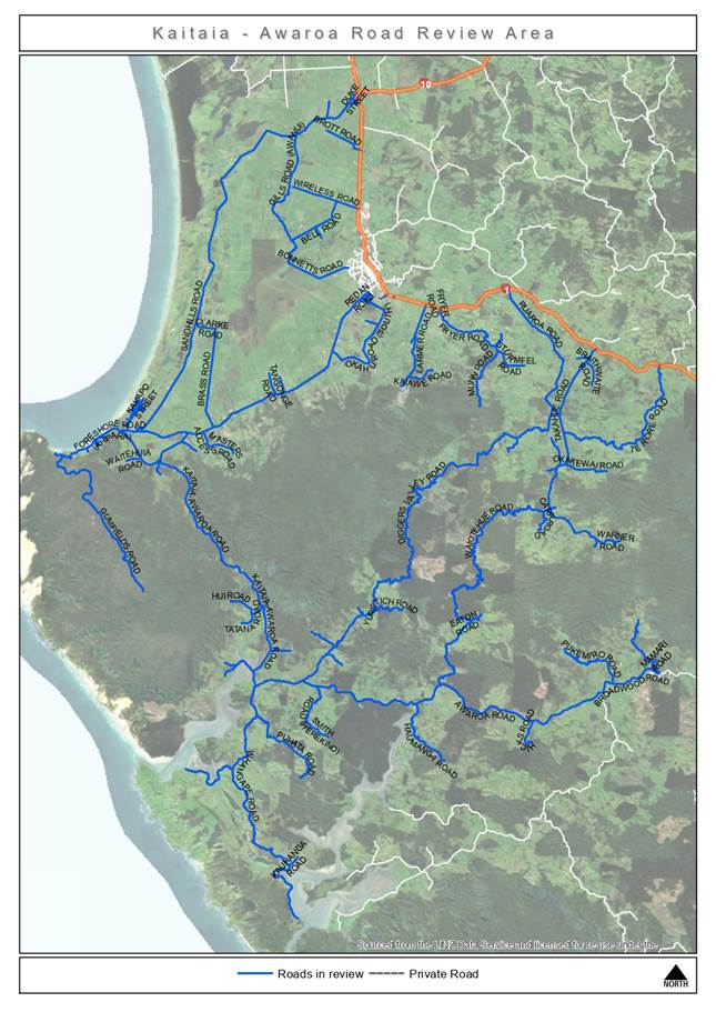
|
Kaikohe-Hokianga
Community Board Meeting Agenda
|
2 June 2021
|
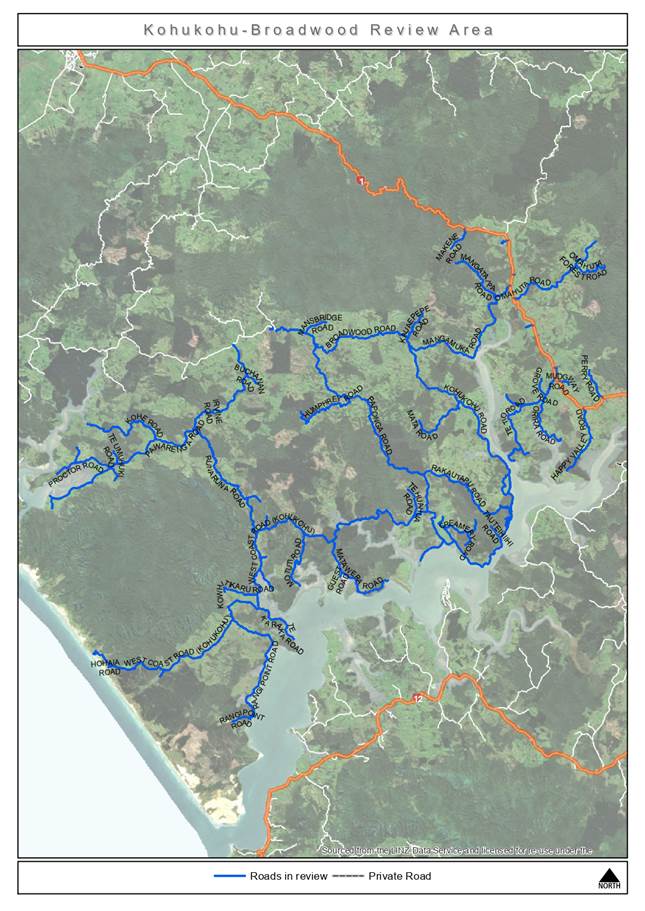
|
Kaikohe-Hokianga
Community Board Meeting Agenda
|
2 June 2021
|