Te
Kaunihera o Tai Tokerau ki te Raki
AGENDA
Strategy and Policy Committee Meeting
Thursday, 30 July 2020
|
Time:
|
9:30 am
|
|
Location:
|
Council Chamber
Memorial Avenue
Kaikohe
|
Membership:
Cr Rachel
Smith - Chairperson
Cr David Clendon
– Deputy Chairperson
Mayor John
Carter
Deputy Mayor
Ann Court
Cr Dave
Collard
Cr Felicity
Foy
Cr Moko
Tepania
Cr John
Vujcich
Bay of
Islands-Whangaroa Community Board Chairperson Belinda Ward
|

|
Authorising Body
|
Mayor/Council
|
|
Status
|
Standing Committee
|
|
COUNCIL COMMITTEE
|
Title
|
Strategy and Policy Committee
Terms of
Reference
|
|
Approval Date
|
19 December 2019
|
|
Responsible Officer
|
Chief Executive
|
Purpose
The purpose of the Strategy and
Policy Committee (the Committee) is to set direction for the district,
determine specific outcomes that need to be met to deliver on that vision, and
set in place the strategies, policies and work programmes to achieve those
goals.
In determining and shaping the
strategies, policies and work programme of the Council, the Committee takes a
holistic approach to ensure there is strong alignment between the objectives
and work programmes of the strategic outcomes of Council, being:
·
Better data and information
·
Affordable core infrastructure
·
Improved Council capabilities and performance
·
Address affordability
·
Civic leadership and advocacy
·
Empowering communities
The Committee will review the
effectiveness of the following aspects:
·
Trust and confidence in decision-making
by keeping our communities informed and involved in decision-making;
·
Operational performance including
strategy and policy development, monitoring and reporting on significant
projects, including, but not limited to:
o
FN2100
o
District wide strategies (Infrastructure/
Reserves/Climate Change/Transport)
o
District Plan
o
Significant projects (not
infrastructure)
o
Financial Strategy
o
Data Governance
o
Affordability
·
Consultation and engagement including
submissions to external bodies / organisations
To perform his or her role
effectively, each Committee member must develop and maintain
his or her skills and knowledge,
including an understanding of the Committee’s responsibilities, and of
the Council’s business, operations and risks.
Power to
Delegate
The Strategy
and Policy Committee may not delegate any of its responsibilities, duties or
powers.
Membership
The Council will determine the
membership of the Strategy and Policy Committee.
The Strategy and Policy
Committee will comprise of at least seven elected members (one of which
will be the chairperson).
|
Mayor
Carter
|
|
Rachel
Smith – Chairperson
|
|
David
Clendon – Deputy Chairperson
|
|
Moko
Tepania
|
|
Ann
Court
|
|
Felicity
Foy
|
|
Dave
Collard
|
|
John
Vujcich
|
|
|
Non-appointed
councillors may attend meetings with speaking rights, but not voting rights.
Quorum
The quorum at a
meeting of the Strategy and Policy Committee is 5 members.
Frequency of
Meetings
The Strategy and Policy Committee shall meet every 6 weeks,
but may be cancelled if there is no business.
Committees
Responsibilities
The Committees responsibilities
are described below:
Strategy
and Policy Development
·
Oversee the Strategic Planning and
Policy work programme
·
Develop and agree strategy and policy
for consultation / engagement;
·
Recommend to Council strategy and
policy for adoption;
·
Monitor and review strategy and policy.
Service
levels (non regulatory)
·
Recommend service level changes and new
initiatives to the Long Term and Annual Plan processes.
Policies and Bylaws
·
Leading the development and review of Council's policies and
district bylaws when and as directed by Council
·
Recommend to Council new or amended bylaws for adoption
Consultation
and Engagement
·
Conduct any consultation processes
required on issues before the Committee;
·
Act as a community interface (with, as
required, the relevant Community Board(s)) for consultation on policies and as
a forum for engaging effectively;
·
Receive reports from Council’s
Portfolio and Working Parties and monitor engagement;
·
Review as necessary and agree the model
for Portfolios and Working Parties.
Strategic
Relationships
·
Oversee Council’s strategic
relationships, including with Māori, the Crown and foreign investors,
particularly China
·
Oversee, develop and approve engagement opportunities triggered
by the provisions of Mana Whakahono-ā-Rohe under the Resource
Management Act 1991
·
Recommend to Council the adoption of
new Memoranda of Understanding (MOU)
·
Meet annually with local MOU partners
·
Quarterly reviewing operation of all
Memoranda of Understanding
·
Quarterly reviewing Council’s
relationships with iwi, hapū, and post-settlement governance entities in
the Far North District
·
Monitor Sister City relationships
·
Special projects (such as Te Pū o
Te Wheke or water storage projects)
Submissions
and Remits
·
Approve submissions to, and endorse
remits for, external bodies / organisations and on legislation and regulatory
proposals, provided that:
o
If there is insufficient time for the
matter to be determined by the Committee before the submission “close
date” the submission can be agreed by the relevant Portfolio Leaders,
Chair of the Strategy and Policy Committee, Mayor and Chief Executive (all
Councillors must be advised of the submission and provided copies if
requested).
o
If the submission is of a technical and
operational nature, the submission can be approved by the Chief Executive (in
consultation with the relevant Portfolio Leader prior to lodging the
submission).
·
Oversee, develop and approve any
relevant remits triggered by governance or management commencing in January of
each calendar year.
·
Recommend to Council those remits that
meet Council’s legislative, strategic and operational objectives to
enable voting at the LGNZ AGM. All endorsements will take into account
the views of our communities (where possible) and consider the unique
attributes of the district.
Fees
·
Set fees in accordance with legislative
requirements unless the fees are set under a bylaw (in which case the decision
is retained by Council and the committee has the power of recommendation) or
set as part of the Long Term Plan or Annual Plan (in which case the decision
will be considered by the Long Term Plan and Annual Plan and approved by
Council).
District
Plan
·
Review and approve for notification a proposed District Plan, a
proposed change to the District Plan, or a variation to a proposed plan or
proposed plan change (excluding any plan change notified under clause 25(2)(a),
First Schedule of the Resource Management Act 1991);
·
Withdraw a proposed plan or plan change under clause 8D, First
Schedule of the Resource Management Act 1991;
·
Make the following decisions to facilitate the administration of
proposed plan, plan changes, variations, designation and heritage order
processes:
§
To authorise the
resolution of appeals on a proposed plan, plan change or variation unless the
issue is minor and approved by the Portfolio Leader District Plan and the Chair
of the Regulatory committee.
§
To decide whether a
decision of a Requiring Authority or Heritage Protection Authority will be
appealed to the Environment Court by council and authorise the resolution of
any such appeal.
§
To consider and approve
council submissions on a proposed plan, plan changes, and variations.
§ To manage the private plan change process.
§ To accept, adopt or reject private plan change
applications under clause 25 First Schedule Resource Management Act (RMA).
Rules and Procedures
Council’s
Standing Orders and Code of Conduct apply to all the committee’s
meetings.
Annual reporting
The Chair of the Committee will
submit a written report to the Chief Executive on an annual basis. The
review will summarise the activities of the Committee and how it has contributed to the Council’s
governance and strategic objectives. The Chief Executive
will place the report on the next available agenda of the governing body.
STRATEGY AND
POLICY COMMITTEE - MEMBERS REGISTER OF INTERESTS
|
Name
|
Responsibility (i.e.
Chairperson etc)
|
Declaration of
Interests
|
Nature of Potential
Interest
|
Member's Proposed
Management Plan
|
|
Hon John Carter QSO
|
Board Member of the
Local Government Protection Programme
|
Board Member of the
Local Government Protection Program
|
|
|
|
Carter Family Trust
|
|
|
|
|
Rachel Smith (Chair)
|
Friends of Rolands Wood
Charitable Trust
|
Trustee
|
|
|
|
Mid North Family
Support
|
Trustee
|
|
|
|
Property Owner
|
Kerikeri
|
|
|
|
Friends who work at Far
North District Council
|
|
|
|
|
Kerikeri Cruising Club
|
Subscription Member and
Treasurer
|
|
|
|
Rachel Smith
(Partner)
|
Property Owner
|
Kerikeri
|
|
|
|
Friends who work at Far
North District Council
|
|
|
|
|
Kerikeri Cruising Club
|
Subscription Member
|
|
|
|
David Clendon
(Deputy Chair)
|
Chairperson – He
Waka Eke Noa Charitable Trust
|
None
|
|
Declare if any issue
arises
|
|
Member of Vision
Kerikeri
|
None
|
|
Declare if any issue
arises
|
|
Joint owner of family
home in Kerikeri
|
Hall Road, Kerikeri
|
|
|
|
David Clendon
– Partner
|
Resident Shareholder on
Kerikeri Irrigation
|
|
|
|
|
David Collard
|
Snapper Bonanza 2011
Limited
|
45% Shareholder and
Director
|
|
|
|
Trustee of Te Ahu
Charitable Trust
|
Council delegate to
this board
|
|
|
|
Deputy Mayor Ann
Court
|
Waipapa Business
Association
|
Member
|
|
Case by case
|
|
Warren Pattinson
Limited
|
Shareholder
|
Building company. FNDC
is a regulator and enforcer
|
Case by case
|
|
Kerikeri Irrigation
|
Supplies my water
|
|
No
|
|
Top Energy
|
Supplies my power
|
|
No other interest
greater than the publics
|
|
District Licensing
|
N/A
|
N/A
|
N/A
|
|
Top Energy Consumer
Trust
|
Trustee
|
Crossover in regulatory
functions, consenting economic development and contracts such as street
lighting.
|
Declare interest and
abstain from voting.
|
|
Ann Court Trust
|
Private
|
Private
|
N/A
|
|
Waipapa Rotary
|
Honorary member
|
Potential community
funding submitter
|
Declare interest and
abstain from voting.
|
|
Properties on Onekura
Road, Waipapa
|
Owner Shareholder
|
Any proposed FNDC
Capital works or policy change which may have a direct impact (positive/adverse)
|
Declare interest and
abstain from voting.
|
|
Property on Daroux Dr,
Waipapa
|
Financial interest
|
Any proposed FNDC
Capital works or policy change which may have a direct impact (positive/adverse)
|
Declare interest and abstain
from voting.
|
|
Flowers and gifts
|
Ratepayer 'Thankyou'
|
Bias/
Pre-determination?
|
Declare to Governance
|
|
Coffee and food
|
Ratepayers sometimes
'shout' food and beverage
|
Bias or
pre-determination
|
Case by case
|
|
Staff
|
N/A
|
Suggestion of not being
impartial or pre-determined!
|
Be professional, due
diligence, weigh the evidence. Be thorough, thoughtful, considered impartial
and balanced. Be fair.
|
|
Warren Pattinson
|
My husband is a builder
and may do work for Council staff
|
|
Case by case
|
|
Ann Court - Partner
|
Warren Pattinson
Limited
|
Director
|
Building Company. FNDC
is a regulator
|
Remain at arm’s
length
|
|
Air NZ
|
Shareholder
|
None
|
None
|
|
Warren Pattinson
Limited
|
Builder
|
FNDC is the consent
authority, regulator and enforcer.
|
Apply arm’s
length rules
|
|
Property on Onekura
Road, Waipapa
|
Owner
|
Any proposed FNDC
capital work in the vicinity or rural plan change. Maybe a link to policy
development.
|
Would not submit.
Rest on a case by case basis.
|
|
Felicity Foy
|
Director - Northland
Planning & Development
|
I am the director of a
planning and development consultancy that is based in the Far North and have
two employees.
Property owner of
Commerce Street, Kaitaia
|
|
I will abstain from any
debate and voting on proposed plan change items for the Far North District
Plan.
|
|
|
|
|
I will declare a
conflict of interest with any planning matters that relate to resource
consent processing, and the management of the resource consents planning team.
|
|
|
|
|
I will not enter into
any contracts with Council for over $25,000 per year. I have previously
contracted to Council to process resource consents as consultant planner.
|
|
Flick Trustee Ltd
|
I am the director of
this company that is the company trustee of Flick Family Trust that owns
properties Seaview Road – Cable Bay, and Allen Bell Drive - Kaitaia.
|
|
|
|
Elbury Holdings Limited
|
This company is
directed by my parents Fiona and Kevin King.
|
This company owns
several dairy and beef farms, and also dwellings on these farms. The Farms
and dwellings are located in the Far North at Kaimaumau, Bird Road/Sandhills
Rd, Wireless Road/ Puckey Road/Bell Road, the Awanui Straight and Allen Bell
Drive.
|
|
|
Foy Farms Partnership
|
Owner and partner in
Foy Farms - a farm on Church Road, Kaingaroa
|
|
|
|
Foy Farms Rentals
|
Owner and rental
manager of Foy Farms Rentals for 7 dwellings on Church Road, Kaingaroa and 2
dwellings on Allen Bell Drive, Kaitaia, and 1 property on North Road,
Kaitaia, one title contains a cell phone tower.
|
|
|
|
King Family Trust
|
This trust owns several
titles/properties at Cable Bay, Seaview Rd/State Highway 10 and Ahipara -
Panorama Lane.
|
These trusts own
properties in the Far North.
|
|
|
Previous employment at
FNDC 2007-16
|
I consider the staff
members at FNDC to be my friends
|
|
|
|
Shareholder of Coastline
Plumbing NZ Limited
|
|
|
|
|
Felicity Foy -
Partner
|
Director of Coastline
Plumbing NZ Limited
|
|
|
|
|
Friends with some FNDC
employees
|
|
|
|
|
Moko Tepania
|
Teacher
|
Te Kura Kaupapa
Māori o Kaikohe.
|
Potential Council
funding that will benefit my place of employment.
|
Declare a perceived
conflict
|
|
Chairperson
|
Te Reo o Te Tai Tokerau
Trust.
|
Potential Council
funding for events that this trust runs.
|
Declare a perceived
conflict
|
|
Tribal Member
|
Te Rūnanga o Te
Rarawa
|
As a descendent of Te
Rarawa I could have a perceived conflict of interest in Te Rarawa Council
relations.
|
Declare a perceived
conflict
|
|
Tribal Member
|
Te Rūnanga o
Whaingaroa
|
As a descendent of Te
Rūnanga o Whaingaroa I could have a perceived conflict of interest in Te
Rūnanga o Whaingaroa Council relations.
|
Declare a perceived
conflict
|
|
Tribal Member
|
Kahukuraariki Trust
Board
|
As a descendent of
Kahukuraariki Trust Board I could have a perceived conflict of interest in
Kahukuraariki Trust Board Council relations.
|
Declare a perceived
conflict
|
|
Tribal Member
|
Te Rūnanga
ā-Iwi o Ngāpuhi
|
As a descendent of Te
Rūnanga ā-Iwi o Ngāpuhi I could have a perceived conflict of
interest in Te Rūnanga ā-Iwi o Ngāpuhi Council relations.
|
Declare a perceived
conflict
|
|
John Vujcich
|
Board Member
|
Pioneer Village
|
Matters relating to
funding and assets
|
Declare interest and
abstain
|
|
Director
|
Waitukupata Forest Ltd
|
Potential for council
activity to directly affect its assets
|
Declare interest and
abstain
|
|
Director
|
Rural Service Solutions
Ltd
|
Matters where council
regulatory function impact of company services
|
Declare interest and
abstain
|
|
Director
|
Kaikohe (Rau Marama) Community
Trust
|
Potential funder
|
Declare interest and
abstain
|
|
Partner
|
MJ & EMJ Vujcich
|
Matters where council
regulatory function impacts on partnership owned assets
|
Declare interest and
abstain
|
|
Member
|
Kaikohe Rotary Club
|
Potential funder, or
impact on Rotary projects
|
Declare interest and
abstain
|
|
Member
|
New Zealand Institute
of Directors
|
Potential provider of
training to Council
|
Declare a Conflict of
Interest
|
|
Member
|
Institute of IT
Professionals
|
Unlikely, but possible
provider of services to Council
|
Declare a Conflict of
Interest
|
|
Member
|
Kaikohe Business
Association
|
Possible funding
provider
|
Declare a Conflict of
Interest
|
2 Apologies
and Declarations of Interest
Members need to
stand aside from decision-making when a conflict arises between their role as a
Member of the Committee and any private or other external interest they might
have. This note is provided as a reminder to Members to review the matters on
the agenda and assess and identify where they may have a pecuniary or other
conflict of interest, or where there may be a perception of a conflict of
interest.
If a Member
feels they do have a conflict of interest, they should publicly declare that at
the start of the meeting or of the relevant item of business and refrain from
participating in the discussion or voting on that item. If a Member thinks they
may have a conflict of interest, they can seek advice from the Chief Executive
Officer or the Team Leader Democracy Support (preferably before the meeting).
It is noted
that while members can seek advice the final decision as to whether a conflict
exists rests with the member.
3 Deputation
No requests for deputations were received at the time of the
Agenda going to print.
4 Reports
4.1 Joint
Climate Change Adaptation Governance Committee
File
Number: A2905655
Author: Roger
Ackers, Manager - Strategy Development
Authoriser: Janice
Smith, Chief Financial Officer
Purpose of the Report
To seek approval from the
Strategy and Policy Committee for the establishment of a Joint Climate Change Adaptation
Governance Committee that is tasked with overseeing the development and
implementation of a Northland region wide climate change adaptation strategy.
To seek approval for the
nomination of Councillor Clendon as the Far North District Council elected
member representative on the proposed Joint Climate Change Committee.
To seek approval to ask
Te Kahu O Taonui to nominate the Far North District Councils tangata whenua
representative on the proposed Joint Climate Change Adaptation Governance
Committee.
To see approval for the
development of policy for the remuneration of non-elected members to committees
of Council.
Executive
Summary
· The Climate Adaptation Te Taitokerau Group, a working group of
administration representatives from the four Councils located in the Northland
region, proposed the establishment of a joint standing Committee to the Mayoral
Forum on 10 February 2020 by submitting a draft terms of reference paper
(attachment 1) to the Forum.
· The Mayoral Forum requested further consultation with Māori
advisory groups within each Council to get feedback on the draft terms of
reference for the proposed joint standing committee.
· This paper responds to the request from the Mayoral Forum and the
draft terms of reference for a proposed Joint Climate Change Adaptation
Governance Committee by recommending that the Strategy and Policy Committee;
o Approve the draft Terms of Reference for the proposed Joint Climate
Change Adaptation Governance Committee and
o approve the appointment of Councillor Clendon to the proposed Joint
Climate Change Adaptation Governance Committee and that
o Te Kahu O Taonui be asked to nominate the Far North District Council
tangata whenua representative on the proposed Joint Climate Adaptation
Governance Committee and
o approve the development of a policy for the remuneration of
non-elected members to committees of Council.
|
Recommendation
That the Strategy and Policy Committee:
a) approve the
forming of a Joint Climate Change Adaptation Governance Committee one tangata
whenua representative from each of the four Councils that are contained in
the Northland Region, these being Northland Regional Council, Whangarei
District Council, Kaipara District Council and Far North District Council and
that;
b) approve that
Councillor Clendon, as the climate change portfolio holder, be appointed as
the Far North District Council elected member representative on the proposed
Joint Climate Change Adaptation Governance Committee and that;
c) approve that
Te Kahu O Taonui be asked to nominate the Far North District Council tangata
whenua representative on the proposed Joint Climate Change Adaptation
Governance Committee and that;
d) approve the
development of a policy for the remuneration of non-elected members to
committees of Council.
|
1) Background
· In
mid-2018 representatives of the administration from Kaipara District Council
(KDC), Whangarei District Council (WDC), Northland Regional Council (NRC) and
Far North District Council (FNDC) concluded that a regional wide consistent and
collaborative approach across the four councils was the preferred way forward
for adapting to the impacts of climate change across the Northland Region
· The
first meeting of representatives from the administration of the four Northland
Councils plus representatives from the administration of the Northland
Transport Alliance (NTA) was held in Whangārei on 23 July 2018. At this
meeting it was agreed that a climate change working group be formed with the
intent of collaborating on issues and approaches to responding to climate
change
· It
was also agreed among attendees at the 23 July 2018 meeting that, to legitimise
and give a mandate to a cross council climate change adaptation working group,
that the endorsement by the Northland Chief Executive Officer and Mayoral
Forums was required
· A
draft Terms of Reference for a Northland wide Climate Change Working Group
(CCWG) was submitted to the Chief Executive Officers Forum on 20 August
2018. The Chief Executive Officers Forum endorsed the Terms of Reference
and appointed the Chief Executive Officer from KDC as the project
sponsor. The membership of CCWG includes staff representatives from FNDC,
NRC, KDC, WDC, NTA and the Four Waters Advisory Group
· The
purpose of the CCWG as written in its Terms of Reference is ‘to develop a
regional collaborative approach to climate change adaptation planning for local
government in Northland. This will include a draft climate change strategy for
Northland and an associated work programme that identifies and addresses
priority issues at both a regional and district level’
· The
CCWG has no delegated authority with recommendations of the group requiring
approval by the relevant council(s) prior to the implementation or adoption or
any strategy, plan or governance document like a term of reference
· Since
its inception the CCWG has been working towards the development of a regional
wide climate change adaptation strategy. This has drawn heavily on the
advice and direction provided by the Ministry for the Environment and case
studies from across New Zealand. A consistent message that has come from
the work and analysis undertaken by the CCWG has concluded the success of climate
change adaptation initiatives relies heavily on having clear governance and
oversight groups in place
· A
paper (attachment one) was submitted to the 10 February 2020 Mayoral Forum
proposing the formation of a joint standing committee consisting of elected
member representatives from FNDC, KDC, WDC and NRC and representatives from iwi
/ hapū as ‘nominated by each council from within their
jurisdiction’. This paper also contained a daft Terms of Reference
for the proposed joint standing committee
· Feedback
from the Mayoral Forum on the paper was ‘that while the concept was
supported there needed to be more consultation with Māori advisory groups
from each council before moving forward’
· The
CCWG intends to take the decision from each of the four Northland Councils on
the proposed joint standing committee to the CEO Forum on 10 August 2020
· On
the endorsement of a Joint Climate Change Adaptation Committee by the Chief
Executive Forum each Council will be required to adopt the establishment of the
Joint Standing Committee as per the requirements of the Local Government Act
(clause 30(1)(b) of Schedule 7 to the Local Government Act 2002).
· The
CCWG has undertaken a renaming exercise in recent months. This group is
now referred to as the Climate Adaptation Te Taitokerau (CATT) Group
· On
7 May 2020 Council adopted a Climate Change Roadmap for the Far North District
Council. The Roadmap included implementation initiatives and the
execution of programmes of work that are being proposed by the CATT Group
· Te
Kahu o Taonui is a collective of Taitokerau iwi chairs from Te Aupouri,
Ngāti Kuri, Te Rarawa, Ngāti Kahu, Ngāi Takoto, Ngāpuhi,
Kahukuraariki, Whangaroa, Ngāti Wai, Ngāti Whātua ki Kaipara and
Te Roroa
2) Discussion
and Options
DISCUSSION
· Councillor
Clendon holds the portfolio for Climate Change for the Far
North District Council, as previously approved by full Council. His appointment
to the proposed joint standing committee aligns with this portfolio
· NRC,
KDC and WDC all have forums with iwi and hapū that have been involved in
the work being undertaken by the CCWG, including the development of the
attached draft terms of reference. FNDC has no such forum where it can
discuss the concept of a joint standing committee or seek an iwi/hapū representative
on such a committee.
· Council
does, however, participate in the Iwi Local Government Chief Executives Forum
and is a signatory to the Mayoral Forum/Iwi Chairs Memorandum of Understanding,
Whanaungatanga Ki Taurangi. While council also has a number of other Memorandum
of Understanding with iwi and/or hapū, the Whanaungatanga ki Taurangi is
the only district wide relationship mechanism.
· The
Far North District Council currently has no specific policy that determines the
remuneration of the non-elected members who are appointed to committees of
Council. Northland Regional Council has such a policy.
OPTIONS
Establishment of a
Joint Climate Change Adaptation Governance Committee
Option One (preferred
option): The Strategy and Policy Committee approves the draft Terms of
Reference for the Joint Climate Change Adaptation Governance Committee as
contained in attachment one to this report.
Under this option the
Strategy and Policy Committee approves the proposed Terms of Reference
(contained in attachment one). If this option is approved Council can
then consider how it will appoint the Far North District Council elected member
representative and the tangata whenua representative on the proposed Joint
Climate Change Adaptation Governance Committee. Administration recommends
this option.
Option Two: The
Strategy and Policy Committee does not approve of a Joint Climate Change
Adaptation Governance Committee
Under this option the
Strategy and Policy Committee does not approve the establishment of the proposed
Joint Climate Change Adaptation Governance Committee. This decision will
in effect cease the Far North District Council’s involvement in the CATT
Group. Under this option the Far North District Council will develop and
implement its own climate change adaptation strategies and plans. This
option would allow the Far North District Council to develop its response to
climate change at its own pace. However choosing this option has the
following disadvantages;
o The
Far North District Council is likely to experience significant reputational
risk, locally, regionally and nationally as the only Council not to sign up to
a joint governance model for climate change in Northland
o The
Far North District Council would not be able to benefit from drawing on the
skills of other originations, particularly the Northland Regional Council who
do the climate change related data modelling for Northland
o The
Far North District Council may not be able to secure national funding for
climate change response initiatives due to its non-participation in any
regional initiatives on climate change.
Option Three:
The Strategy and Policy Committee requests that the draft Terms of Reference
for the Joint Climate Change Adaptation Governance Committee be modified
Under this option the
Strategy and Policy Committee reviews and requests modification to the proposed
Terms of Reference (contained in attachment one) that ensures that the intent
of this document is aligned with the Far North District Councils goals and
objectives. Under this option, on direction from the Strategy and Policy
Committee, administration will draft up changes to the Terms of Reference that
will be submitted to the CATT group for further consideration before an agreed
Terms of Reference is submitted to the Northland Chief Executive Officers
Forum.
Appointment of Far
North District Elected Member representative on the proposed Joint Climate
Change Adaptation Governance Committee
Administration recommends
that Council appoints the climate change portfolio holder, Councillor Clendon,
as the Far North District Council nominated elected member representative on
the proposed Joint Climate Change Adaptation Governance Committee.
Appointment of the Far
North District tangata whenua representative to the proposed Joint Climate
Change Adaptation Governance Committee
Option One (preferred
option): The Far North District Council tangata whenua representative on the
proposed Joint Climate Change Adaptation Governance Committee is appointed by
Te Kahu O Taonui
Using the Whanaungatanga
ki Taurangi agreement, Council will approach Te Kahu o Taonui with a view that
Te Kahu o Taonui appoint a member as the Far North tangata whenua
representative on to the Joint Climate Change Adaptation Governance Committee
as the Far North District representative.
This approach would see
Council give weight to the relationship agreement it signed at Waitangi in
February 2019. It also provides a District wide perspective from iwi/hapū
due to the nature of Te Kahu o Taonui being representative of the districts
iwi.
Engaging with Te Kahu o
Taonui would also develop trust and build stronger relationships between the
governance of iwi and Council which would have wider beneficial outcomes for
Council and iwi.
Under this option the Far
North District Council will need to adopt a policy for remuneration of
non-elected members who are appointed to committees of Council.
Option Two: The
Far North District Council tangata whenua representative on the proposed the
Joint Climate Change Adaptation Governance Committee is appointed via a public
expression of interest process
Council will advertise in
the public notices and undertake a tender process to appoint a tangata whenua
non-elected member on to the Joint Climate Change Adaptation Governance Committee
as the Far North District representative. This process would see council on its
own, without discussion or endorsement by iwi/hapū, appoint a tangata
whenua representative to the proposed joint committee.
Option Three: The
Council makes a direct appointment of the Far North District Council tangata
whenua representative on the proposed Joint Climate Change Adaptation
Governance Committee
This option would see
Council alone deciding as to who would be best qualified to represent the views
of Māori in the Far North District on the proposed Joint Climate Change
Adaptation Governance Committee.
Reason
for the recommendation
· Administration
recommends that the Strategy and Policy Committee approves the proposed Terms
of Reference (attachment one) to demonstrate the Far North District
Council’s commitment to a Northland wide approach to climate change
adaptation. This option has the following advantages:
o This
will ensure a regionally consistent approach to climate change adaptation and
allow for greater synergies with policies and strategies, and Resource
Management Act planning
o A
regional approach will enable Northland Councils to lobby for central
government financial contributions for projects given the collaborative nature
of the arrangement
· Administration
recommends the appointment of Councillor Clendon as the elected member
representative on the proposed Joint Climate Change Adaptation Governance
Committee as it aligns and shows commitment to the portfolio assignment that
Council has made
· Administration
recommends that the appointment of a Far North District Council tangata whenua
representative to the proposed Joint Climate Change Adaptation Governance
Committee is best determined and endorsed by Te Kahu O Taonui as this respects
the mana of this group and demonstrates a commitment to and respect for the
relationship between the Far North District Council and Te Kahu O Taonui.
This option has the following advantages:
o Engaging
Te Kahu o Taonui responds to Whanaungatanga Ki Taurangi and is an appropriate
response by the Far North District Council.
o It
provides for the Far North District Councils obligations as prescribed in the
Local Government Act 2002, section 81 by providing Māori input into the
decision-making processes of council.
· Administration
recommends the development and adoption of a policy for the remuneration of
non-elected members to committees of Council.
3) Financial
Implications and Budgetary Provision
There are no direct
financial implications associated with the recommendation made in this
paper. The development of a policy for the remuneration of non-elected
members to committees of Council will articulate the quantum and form of
remuneration of those appointed to a committee. These details will be contained
in a future paper to the committee.
Attachments
1. 10 February 2020
Mayoral Forum - Joint Council Climate Change Adaptation Committee Proposal and
draft terms of reference - A2906404 ⇩ 
Compliance schedule:
Full consideration has been given to the provisions of the
Local Government Act 2002 S77 in relation to decision making, in particular:
1. A
Local authority must, in the course of the decision-making process,
a) Seek
to identify all reasonably practicable options for the achievement of the
objective of a decision; and
b) Assess
the options in terms of their advantages and disadvantages; and
c) If
any of the options identified under paragraph (a) involves a significant
decision in relation to land or a body of water, take into account the
relationship of Māori and their culture and traditions with their
ancestral land, water sites, waahi tapu, valued flora and fauna and other
taonga.
2. This
section is subject to Section 79 - Compliance with procedures in relation to
decisions.
|
Compliance
requirement
|
Staff
assessment
|
|
State the level of significance
(high or low) of the issue or proposal as determined by the Council’s
Significance and Engagement Policy
|
The recommendations made in this
paper do not exceed any of the significance thresholds contained in the
Council’s Significance and Engagement Policy.
|
|
State the relevant Council
policies (external or internal), legislation, and/or community outcomes (as
stated in the LTP) that relate to this decision.
|
Clause 30(1)(b) of Schedule 7 to
the Local Government Act 2002 gives the power to a local authority to appoint
a joint committee with another local authority or other public body as per
the recommendations in this report.
The following Council policy is
relevant, but not directly related, to the recommendation in this report:
· Appointment
and Remuneration of Directors for Council Organisations.
|
|
State whether this issue or
proposal has a District wide relevance and, if not, the ways in which the
appropriate Community Board’s views have been sought.
|
The recommendation in this report
has district wide relevance.
|
|
State the possible implications for Māori
and how Māori have been provided with an opportunity to contribute to
decision making if this decision is significant and relates to land and/or
any body of water.
|
Māori will be
disproportional impacted by the impacts of climate change. In providing for a
standing committee to develop adaption strategies which is a co-governance
arrangement of iwi and councils will provide Māori direct input into
council decisions around Climate Change Adaption.
|
|
Identify persons likely to be
affected by or have an interest in the matter, and how you have given consideration
to their views or preferences (for example – youth, the aged and those
with disabilities.
|
There are no specific persons
that will be affected by or have an interest in the recommendation in this
report that required special consideration of their views or preferences.
|
|
State the financial implications
and where budgetary provisions have been made to support this decision.
|
There are no direct financial
implications associated with the recommendation made in this paper.
|
|
Chief Financial Officer review.
|
The Chief Financial Officer has
reviewed this report.
|
|
Strategy and Policy Committee Meeting Agenda
|
30 July 2020
|
Joint climate change adaptation committee
Terms of Reference
10 February 2020
Background
Climate change poses significant risks to the
environment and people of Te Taitokerau - local government has responsibilities
in reducing the impact of climate change (adaptation). It is essential that
councils, communities and iwi / hapū work collaboratively to ensure an
effective, efficient and equitable response to the impacts of climate change.
Work on adaptation has already started between council staff with the formation
of a joint Te Taitokerau Councils Climate Change Adaption Group and the
development of a Climate Change Adaptation Strategy for Taitokerau. The
formation of a joint standing committee of the Far North, Kaipara and Whangarei
district councils and Northland Regional Council elected council members and
iwi / hapū is fundamental to ensuring these outcomes are achieved in a
coordinated and collaborative way across Te Taitokerau.
Role and Responsibilities
1) Provide direction and oversight of
the development and implementation of climate change adaptation activities by
local government in Te Taitokerau
2) Receive advice and provide direction
and support to the Te Taitokerau Councils Climate Change
Adaption Group
3) Make recommendations to member
councils to ensure a consistent regional approach is adopted to climate change
adaptation activities
4) Act collectively as an advocate for
climate change adaptation generally and within the individual bodies represented
on the Committee
5) Ensure the bodies represented on the
Committee are adequately informed of adaptation activity in Te Taitokerau and
the rationale for these activities
6) Ensure the importance of and the
rationale for climate change adaptation is communicated consistently within Te
Taitokerau
7) Receive progress reports from the Te
Taitokerau Councils Climate Change Adaption Group
Membership
The Joint Climate Change Adaptation Committee (the committee)
is a standing committee made up of elected members from the Far North, Kaipara
and Whangarei district councils, the Northland Regional Council and
representatives from Northland hapū and iwi.
The committee shall have eight members as follows:
One elected member from: Kaipara
District Council
Far
North District Council
Whangarei
District Council
Northland Regional Council
Iwi / hapū members: One
representative from iwi / hapū nominated by each council from within their
jurisdiction. Where possible, this nomination should follow recommendations
from council Māori advisory groups or committees.
Each council shall also nominate one alternative elected
member and one alternative iwi / hapū member who will have full speaking
and voting rights when formally acting as the alternate.
Status
The Committee is a joint standing committee of council as
provided for under Clause 30(1)(b) of Schedule 7 of the Local Government Act
2002 and shall operate in accordance with the provisions of Clause 30A of that
Act. The committee is an advisory body only and has no powers under the Local
Government Act 2002 (or any other Act) other than those delegated by decision
of all member councils. The joint standing committee shall operate under
Northland Regional Council Standing Orders.
Committee Chair and deputy Chair:
The Chair and Deputy Chair is to be elected from members at
the first meeting of the committee.
Quorum
At least 50% of members shall be present to form a quorum.
Meetings
The Committee shall meet a minimum of two times per annum.
Service of meetings:
The
Northland Regional Council will provide secretarial and administrative support
to the joint committee.
Draft
agendas are to be prepared by the Te Taitokerau Councils Climate Change
Adaption Group and approved by the Chair of the Committee prior to the
Committee meeting.
Remuneration
Remuneration and / or reimbursement for costs incurred by
council members is the responsibility of each council.
Respective iwi / hapū representatives will be remunerated
and reimbursed by the nominating council in accordance with the Northland
Regional Council Non-Elected Members Remuneration Policy.
Amendments
Any amendment to the Terms of Reference or other arrangements
of the Committee shall be subject to approval by all member councils.
4.2 Options
Report - Parks and Reserves General Policies Development
File
Number: A2885500
Author: Caitlin
Thomas, Strategic Planner
Authoriser: Darrell
Sargent, General Manager - Strategic Planning and Policy
Purpose of the Report
For the Strategy and
Policy Committee to consider an analysis of options for the appropriate
management of parks and reserves through policies, and to make a recommendation
to Council for adoption of the most appropriate option. A detailed discussion
of options is contained in the attached report.
Executive Summary
· Parks and Reserves are lands’ that form Council’s open
space suite. Reserves are lands that are classified under the Reserves Act 1977
for a specific purpose, whereas parks are lands that are held for reserve
purposes but have not been classified under the Reserves Act.
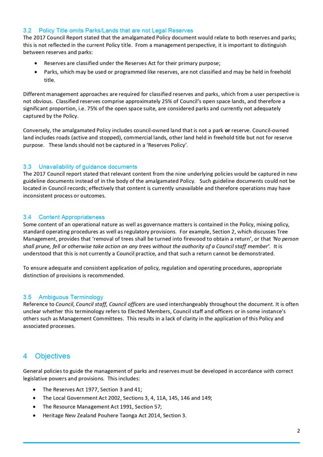
· The current Reserves Policy was adopted by Council in 2017 as an
amalgamation of nine former reserves-related policies. The problem definition
and issues and options study, which led to Council’s May 2020 resolution
to develop a new reserve bylaw, identified several concerns and problems
arising from the 2017 policy amalgamation, including the omission to seek
public input, distinction between reserves and park lands, lack of clarity and
incorporation of regulatory provisions and standard operating procedures, while
other critical content was removed. The review of the current Reserve Policy
further identified inconsistencies with legislation, delegations and as a
result has been deemed not fit for purpose.
· The attached report discusses identified shortfalls and provides two
options to proceed with the management of parks and reserves through the use of
policy. The options discuss:
1. Do nothing/status quo (retain the 2017 Reserves Policy Document);
2.
Develop new General Policies for Parks and Reserves.
· Administration recommends Option 2.
|
Recommendation
The Strategy and
Policy Committee agrees and recommends to Council that new general policies
for the management of parks and reserves be developed.
|
1) Background
The problem definition
and issues and options analysis for the management and regulation of parks and
reserves, which, on May 15 2020, led to Council’s resolution to develop a
new Parks and Reserve Bylaw, included the review of the current Reserve Policy.
The Reserve Policy was
adopted by Council in March 2017, based on the amalgamation of nine former
reserve-related policies. The review of the policy identified several
concerns and problems arising from the 2017 policy amalgamation, including the
omission to seek public input on matters of significance, distinction between
reserves and park lands and their management requirements, lack of clarity,
incorporation of regulatory provisions and standard operating procedures, while
other critical content was removed. The review of the current Reserve Policy
further identified omissions of former content, inconsistencies with
legislation and matters of delegations for decision-making.
The review found that the
Reserve Policy does not create well-developed statements of position on ongoing
or recurring matters or provide direction for responses or actions of staff, or
for decisions of Council or a Committee.
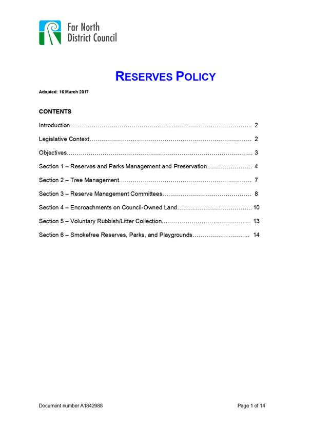
The current Reserve Policy is attached to this report.
2) Discussion and Options
Brief Summary of Issues/Context
Council’s options
for the management of reserves and Council-owned lands which fulfil a similar
function but are not classified under the Reserve Act include:
· retaining
the status quo, i.e. continue with the implementation of the current Reserve
Policy, and
· developing
new general parks and reserves policies, to better address the identified
problems and provide improved community outcomes.
The attached issues and
options report provides a detailed discussion of identified problems and their
impact on decision-making and operations. A summary is provided below:
· The
amalgamation resulted in changes in content, including omission or removal of
policies which are deemed to be significant. At the time, no public
consultation was undertaken. As a result, the Reserve Policy is not
reflective of community needs and aspirations for parks and reserve lands.
· The
Reserve Policy refers to reserves only in its title, omitting non-classified
parks. It is important to distinguish between classified and non-classified
reserves, given their dedicated purpose and different management regimes
subject to applicable legislation. This impacts and confuses dialogue
with the public with respect to opportunities and constraints of these lands.
· Conversely,
other lands that do not form part of the open space suite ( for example the
road corridor) are address in the Reserve Policy, but should be removed.
· Some
content is inconsistent with if not contrary to applicable legislation
including the Reserves Act 1977, the Local Government Act 2002 or the Resource
Management Act 1991, or not give effect to National or Regional Policy
Statements.
· Whilst
discussed, supporting documents to standardize processes and operating
procedures were not created and remain unavailable. This results in
inconsistent responses and administration of parks and reserve management.
· Some
content of Reserve Policy is regulatory in nature and should be contained in a
bylaw rather than a policy.
· Terminology
is used interchangeably throughout causing a lack of clear direction if not
confusion.
· Some
content restricts elected members in the exercise of their delegations.
Reason
for the recommendation
Developing new parks and
reserves general policies is recommended in accordance with applicable
legislation including the Reserves Act 1977, the Local Government Act 2002, the
Resource Management Act 1991 and Heritage New Zealand/Pouhere Taonga Act 2014.
Reasons for this
recommendation include the development of a fit for purpose policy, which:
· Is
compliant with legislation,
· Considers
both classified reserves and parks,
· Is
consistent with the District Plan and enables the development of future
Engineering Standards, future Parks and Reserves Bylaw, and standard operating
procedures and processes etc,
· Follows
best-practice while being locally relevant,
· Provides
policy statements for all identified matters and problems requiring guidance
and direction.
3) Financial Implications and Budgetary
Provision
The development of new
parks and reserves general policies will not immediately indicate any financial
implications and can be completed within current budgets.
Attachments
1. Options Report
Parks and Reserves General Policies Review and Development - A2910437 ⇩ 
2. Far North
District Council Reserves Policy 2017 - A2905609 ⇩ 
Compliance schedule:
Full consideration has
been given to the provisions of the Local Government Act 2002 S77 in relation
to decision making, in particular:
1. A Local authority
must, in the course of the decision-making process,
a) Seek to identify all
reasonably practicable options for the achievement of the objective of a
decision; and
b) Assess the options in
terms of their advantages and disadvantages; and
c) If any of the options
identified under paragraph (a) involves a significant decision in relation to
land or a body of water, take into account the relationship of Māori and
their culture and traditions with their ancestral land, water sites, waahi
tapu, valued flora and fauna and other taonga.
2. This section is
subject to Section 79 - Compliance with procedures in relation to decisions.
|
Compliance
requirement
|
Staff
assessment
|
|
State
the level of significance (high or low) of the issue or proposal as
determined by the Council’s
Significance and Engagement Policy
|
This
meets a High Significance threshold as the proposal will likely generate
considerable community interest.
|
|
State
the relevant Council policies (external or internal), legislation, and/or
community outcomes (as stated in the LTP) that relate to this decision.
|
Reserves
Act 1977 – section 3, and 41 which relate to creation of policy in the
process of developing Reserve Management Plans.
Local
Government Act 2002 – sections 3, 4, 11A, 77, 145, 146 and 149.
Te
Tiriti o Waitangi – section 4.
Heritage
NZ/Pouhere Taonga Act 2014 – section 3.
Resource
Management Act 1991 and NZCPS.
NPS
– Urban Development, Indigenous Biodiversity.
District
Plans – Open Space/Zones
Northland
Regional Policy Statements - various.
Contribution
towards meeting community outcomes (as stated in the LTP) by way of a safe
and healthy district, a sustainable and liveable environment, and a vibrant
and thriving economy through thorough decision making as it relates to the
management and operations of Councils parks and reserves.
|
|
State
whether this issue or proposal has a District wide relevance and, if not, the
ways in which the appropriate Community Board’s views have been sought.
|
This
proposal has District wide relevance.
|
|
State the possible implications for
Māori and how Māori have been provided with an opportunity to
contribute to decision making if this decision is significant and relates to
land and/or any body of water.
|
There
are implications for Māori as this relates to the activities on public
land and in some instances, adjacent bodies of water. It is recommended that
key stakeholder engagement with Māori is conducted in the drafting of
policies.
|
|
Identify
persons likely to be affected by or have an interest in the matter, and how
you have given consideration to their views or preferences (for example
– youth, the aged and those with disabilities.
|
Many
parties in the community will be interested or consider themselves affected
including individuals as well as special interests groups and organisations
such as: mana whenua and tangata whenua iwi (see Iwi/Hapu Management Plans),
Heritage NZ/Pouhere Taonga, User groups; lessees and licensees, sports
and recreation clubs and general users of facilities – including
children, the elderly and those with disabilities), event managers.
Management groups – Hall Management committees etc, Health Department,
Northland Regional Council, Department of Conservation, Advocacy Groups
– e.g. Vision Kerikeri, Friends of Kerikeri Domain, Rotary Groups etc.
Special interest groups – Forest and Bird, Bay of Island Watchdogs,
Walking Access. Tourism Association. It is recommended that other key
stakeholder engagement is conducted in the drafting of the bylaw.
|
|
State
the financial implications and where budgetary provisions have been made to
support this decision.
|
Currently
there are no financial implications.
|
|
Chief
Financial Officer review.
|
The
Chief Financial Officer has reviewed this report.
|
|
Strategy and Policy Committee Meeting Agenda
|
30 July 2020
|
|
Strategy and Policy
Committee Meeting Agenda
|
30 July 2020
|
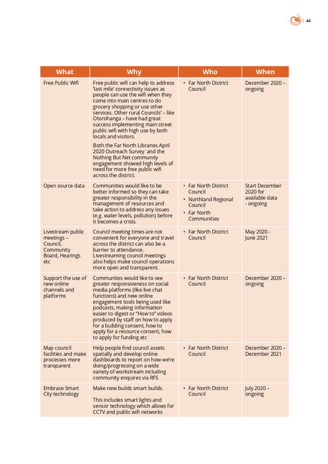
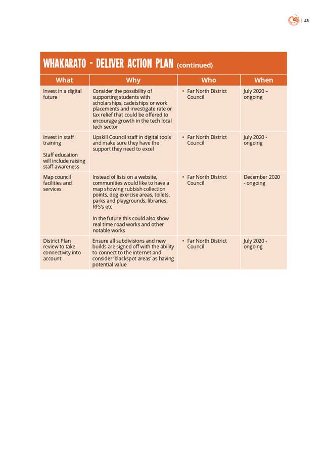
4.3 Nothing
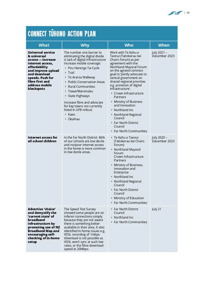
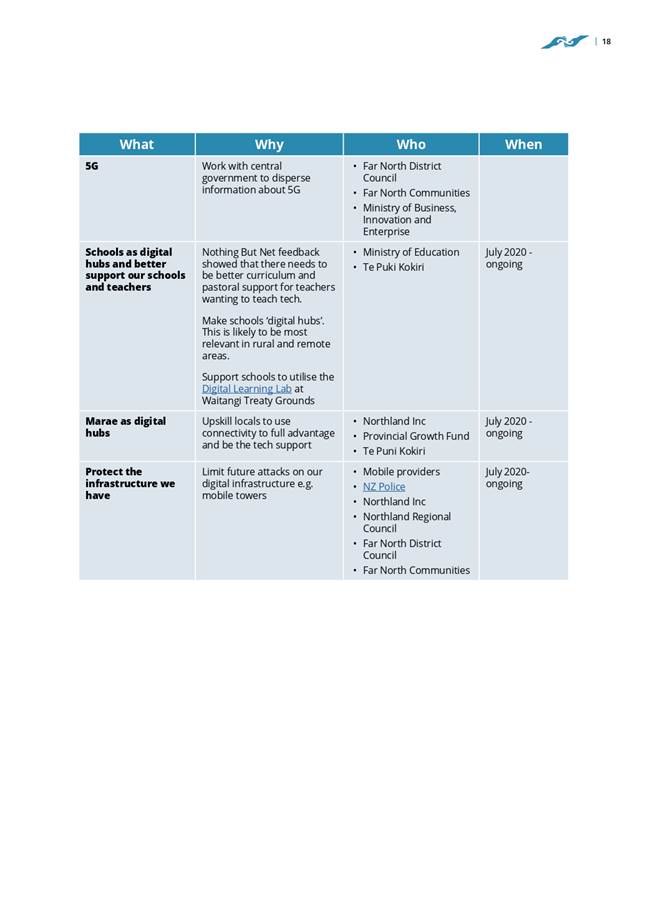
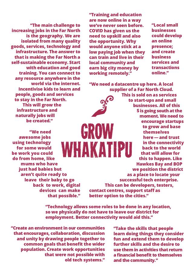
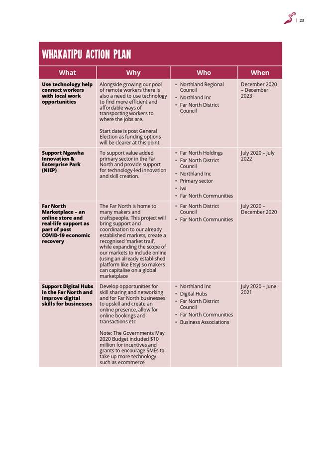
But Net Far North Digital Strategy
File
Number: A2905122
Author: Ana
Mules, Team Leader - Community Development and Investment
Authoriser: Darrell
Sargent, General Manager - Strategic Planning and Policy
Purpose of the Report
To present the Nothing
But Net Far North Digital Strategy to the Strategy and Policy Committee.
Executive Summary
· There
is an increasing reliance on digital and those without connectivity or the
skills to use it risk getting further left behind.
· The
COVID-19 pandemic and resulting nationwide lockdown further exposed the digital
divide across Northland.
· This
digital strategy & action plan was developed with input from internal and
external reference groups and the public via a digital campaign called Nothing
But Net.
· The
strategy recommends immediate actions to address the digital divide in the Far
North.
|
Recommendation
That the Strategy
and Policy Committee recommend that Council adopt the Nothing But Net Far
North Digital Strategy and commits to delivering on the actions in the plan
as part of the 2021-2031 Long Term Plan.
|
Background
The digital divide is the
gap between those who have connectivity and the skills to use it and those who
do not. It is the result of inadequate or lacking digital infrastructure,
difficulties in access and affordability, poor digital literacy and capability
and relevance. The COVID-19 pandemic and resulting nationwide lockdown has
further exposed the digital divide across Northland.
In response to the
digital challenges faced by our communities in lockdown, and while connectivity
and digital skills were top of mind, staff considered it an opportune time to
start a conversation about how we could become a more digitally enabled
district. Using co-design methodologies and a new and innovative online
engagement tool (Video Ask), people were asked a series of
questions that linked the 4 wellbeing’s and digital connectivity.
Called ‘Nothing But
Net’, engagement ran for a 2-week period (1 May - 15 May) and 118 full
and complete responses (i.e. all 9 questions answered) were submitted over this
time. Hundreds more submitted answers to a few questions only or simply
‘clicked through’ to find out more. There were well over 1000
individual responses in total.
In addition to the
qualitative data collected through Nothing But Net, the Northland Digital
Enablement Group’s annual Broadband Speed Test Surveys (2016-2020)
provide quantitative data on broadband speeds and insight into ongoing
infrastructure challenges. Both these pieces of work actively involved key stakeholders, enabling and empowering
the people affected by the issues to contribute to developing the solutions, and they have helped inform this
piece of work, the Nothing But Net Far North Digital Strategy.
The ‘Nothing But
Net’ strategy and action plan is a 3.5 year plan that that will be used
to support our district’s digital future by directly addressing the
digital divide. Internal and
external reference groups have been established to provide feedback
and guidance and care has been taken to ensure Nothing But Net meets the
immediate needs of our communities.
The strategy content and
structure is a direct result of community contributions and an external
reference group of industry professionals. The final draft was presented back
to all contributors for refinement. This iterative, co-design process has
ensured the resulting document is fit for purpose and reflects the ideas and
aspirations of our communities.
Discussion and Next Steps
Eliminating the digital divide in the Far North will take
many hands but with a strategy, organisations and
individuals can work together towards the shared goals of ensuring that
everyone is empowered by digital technology, our economy is supported, and no
one is left behind.
Staff ask that the
Strategy and Policy Committee receives the Nothing But Net Far North Digital
Strategy and recommend that Council adopts the Strategy and commits to
delivering on the actions in the plan as part of the 2021-2031 Long Term Plan.
Financial Implications and Budgetary Provision
There are no financial implications.
Attachments
1. NBN Final Version
Strat and Policy Committee 3 July 2020 - A2912339 ⇩ 
Compliance schedule:
Full consideration has been given to the provisions of the
Local Government Act 2002 S77 in relation to decision making, in particular:
1. A
Local authority must, in the course of the decision-making process,
a) Seek
to identify all reasonably practicable options for the achievement of the
objective of a decision; and
b) Assess
the options in terms of their advantages and disadvantages; and
c) If
any of the options identified under paragraph (a) involves a significant
decision in relation to land or a body of water, take into account the
relationship of Māori and their culture and traditions with their
ancestral land, water sites, waahi tapu, valued flora and fauna and other
taonga.
2. This
section is subject to Section 79 - Compliance with procedures in relation to
decisions.
|
Compliance
requirement
|
Staff
assessment
|
|
State the level of significance
(high or low) of the issue or proposal as determined by the Council’s Significance and Engagement Policy
|
Low degree of significance.
Initiatives/budget items allocated as a result of the strategy may be
considered significant but this will happen as part of Long Term or Annual
Planning.
|
|
State the relevant Council
policies (external or internal), legislation, and/or community outcomes (as
stated in the LTP) that relate to this decision.
|
Legislatively, this strategy
speaks to community wellbeing and the purpose of local government.
|
|
State whether this issue or
proposal has a District wide relevance and, if not, the ways in which the
appropriate Community Board’s views have been sought.
|
District-wide relevance.
Community Board views have not been sought. An external reference group of
industry professionals contributed significantly.
|
|
State the possible implications for Māori
and how Māori have been provided with an opportunity to contribute to
decision making if this decision is significant and relates to land and/or
any body of water.
|
Targeted engagement with iwi/hapu
was not carried out in the development of the strategy but iwi leaders were
provided with a copy of the draft and their feedback invited.
|
|
Identify persons likely to be
affected by or have an interest in the matter, and how you have given
consideration to their views or preferences (for example – youth, the
aged and those with disabilities.
|
Digital connectivity is an issue
that attracts a lot of attention in the Far North. Almost every household
will be affected by the outcomes of this strategy once it has been
implemented.
|
|
State the financial implications
and where budgetary provisions have been made to support this decision.
|
None. Future costs for the
implementation of the strategy will be taken through long term and/or annual
planning processes.
|
|
Chief Financial Officer review.
|
The Chief Financial Officer has
reviewed this report.
|
|
Strategy and Policy Committee Meeting Agenda
|
30 July 2020
|


5 Information
Reports
5.1 Section
35 Report - Review of the Efficiency and Effectiveness of the Operative Far
North District Plan
File
Number: A2870725
Author: Emily
Robinson, Policy Planner
Authoriser: Darrell
Sargent, General Manager - Strategic Planning and Policy
Purpose of the Report
To inform the Committee
of Council’s monitoring and reporting responsibilities under Section 35
of the Resource Management Act 1991 (RMA), and for the Committee to receive the
report, “Review of Efficiency and Effectiveness of the Far North District
Plan”.
Executive
SummarY
Councils are required to
gather information, undertake monitoring and keep records in order to
effectively carry out their functions under Section 35 of the Resource
Management Act (1991). At least every 5 years, Council must prepare a report on
the efficiency and effectiveness of the rules, policies and other methods in
its plan, and make this report publicly available. The District Plan team have
prepared the Section 35 report to assess the efficiency and effectiveness of
the Operative District Plan in fulfilling the sustainable management purpose of
the RMA.
|
Recommendation
That the Strategy
and Policy Committee receive the report, “Section 35 Report - Review of
the Efficiency and Effectiveness of the Operative Far North District Plan under
Section 35 of the Resource Management Act”.
|
BackgrounD
Section 5 of the RMA (the
Act) establishes the purpose of the Act as being the sustainable management of
natural and physical resources by managing the use, development and protection
of these resources. Council’s are required under Section 35 of the Act to
produce a report at least every 5 years which reports on the efficiency and
effectiveness of policies, provisions and other methods within their plan. The
Section 35 reports draw on data gathered and reports kept from resource consent
applications, as well as monitoring programs that are undertaken to fulfil the
obligations of the RMA. The current report uses data from 2013 to 2018 in order
to assess the efficiency and effectiveness of the District Plan.
Ø The
Operative Far North District Plan
The
Far North District Plan is the principal planning document to achieve the
sustainable management purpose of the Act. The Plan was mostly operative in
2007 and became fully operative in September 2009. As a previous Section 35
report focussed on the years preceding 2015, the current report will focus on
the 2013-2018 period. The report uses resource consent data from this period
gathered from internal and external sources and draws conclusions about the
efficiency and effectiveness of the Far North District Plan from this data.
Ø Purpose of the Section 35
Report
While
the principal purpose of the Section 35 report is to gauge the efficiency and
effectiveness of the District Plan, the report also enables Council the
opportunity to reflect and improve on internal processes by understanding
emerging trends in resource consent applications and associated monitoring
programs within the District. This also assists the District Plan team in their
authoring of Section 32 reports for the Proposed District Plan, due for
notification at the end of 2020. While there are many new
responsibilities and structural changes to the way plans must now be prepared
under the National Planning Standards, the analysis of plan efficiency and
effectiveness will directly inform the need for provisions and the relevant
thresholds for setting rules and associated performance standards for different
activities in the new District Plan.
Ø Findings
and Conclusions of the Section 35 Report
The Section 35 report enables us to examine resource consent trends over
the period between 2013 and 2018. This analysis reports on both the efficiency
and effectiveness of the plan, while informing our plan making process. The
below trends emerged from the Section 35 analysis:
· The
number of resource consents granted per financial year has increased over the
past 5 years, with the largest proportion of resource consents occurring in the
rural environment. In particular, the Rural Production zone has seen the
largest number of resource consents for any one zone.
· The
large amount of consents in the rural environment enables us to gain an
understanding of the development pressures which exist in the Far North and can
be taken into account for the proposed District Plan. For example, an increase
in the amount of consents in the rural environment may indicate that development
is occurring where the plan does not anticipate it and this may be due to
factors including infrastructure pressures, or not having adequate amounts of
urban zoned land for development.
· A
large portion of resource consents were granted in Kerikeri and Northern
communities over the 5 year reporting period. This is consistent with known
growth patterns in each of these areas. In particular, Kerikeri had the most
resource consents for any one place in the Far North.
· Each
zone was analysed to give an indication of what types of consents were granted
in these zones, including the main breaches for that zone. This information
gives us an idea of the most common consent types and will assist in the
District Plan review.
Discussion
and Next Steps
Under Section 35 of the
RMA, Council are required to produce a report on the efficiency and
effectiveness of the Plan, and to release this report to the public.
Previously, a comprehensive report was produced in 2015 which was taken to
Council at the time. The current Section 35 report will be made available to
the public, in order to ensure that they are able to participate in the RMA
process, and to ensure that our internal consenting processes are transparent.
Financial Implications and Budgetary Provision
There are no direct
financial implications as a result of the Section 35 report, however it is
anticipated that the report will be used as a tool in the current plan making
process, and may enable Council to review internal processes in order to create
efficiencies in both consenting and monitoring in the future.
Attachments
1. Section 35 Report
- A2873239 ⇩ 
|
Strategy and Policy Committee Meeting Agenda
|
30 July 2020
|
|
 
A
Review of the Efficiency and Effectiveness of the Far North District Plan
A
report prepared under Section 35 of the Resource Management Act (1991)
April 2020
|
Table
of Contents
Summary Report
1 Background
1.1 Introduction
1.2 Legislative
changes
1.2.1 National
Direction
1.2.2 Local
Direction
1.3 Post-operative
plan changes
1.4 Data
sources
2 District
Wide Analysis
2.1 Development
trends
2.1.1 Comparison
between building consents and land use resource consents
2.1.2 Number
of resource consents granted
2.2 Resource
consent location analysis
2.3 Resource
consent processing
2.4 Resource
consent costs
2.5 Deemed
permitted boundary consents
2.6 Designations
3 Environment
trends and analysis
3.1 Urban
environment
3.2 Rural
environment
3.3 Coastal
environment
4 District
wide reporting
4.1 Tangata
Whenua
4.2 Outstanding
natural landscapes and features
4.3 Indigenous
Flora and Fauna
5 Appendices
Appendix A - Effects Based Rule Thresholds
Appendix B – Key Dates, Plan Changes
Appendix C - Section 35 Report 2015
Summary Report
Councils are required to gather
information, undertake monitoring and keep records in order to effectively
carry out their functions under Section 35 of the Resource Management Act (RMA
1991). At least every 5 years, Council must prepare a report on the
effectiveness and efficiency of the rules, policies and other methods in its
plan, and make this report publicly available. Administration have
prepared the Section 35 report to assess and report on the effectiveness and
efficiency of the Operative District Plan in fulfilling the sustainable
management purpose of the RMA. The report specifically focusses on the period
between 2013 and 2018, as another Section 35 report was prepared for the
preceding period. The Section 35 report will also act to inform Administration
in the plan making process through the consolidated review of the District
Plan, with notification of the Proposed District Plan due to occur in the
latter half of 2020. As well as this, this report aims to guide internal
processes in both the monitoring and resource consent spaces.
Key findings
· The number of resource consents
granted per financial year has increased over the past 5 years, with the
largest proportion of resource consents occurring in the rural environment. In
particular, the Rural Production zone has seen the largest number of resource
consents for any one zone.
· The large amount of consents in the
rural environment enables us to gain an understanding of the development
pressures which exist in the Far North and can be taken into account for the proposed
District Plan. For example, an increase in the amount of consents in the rural
environment may indicate that development is occurring where the plan does not
anticipate it and this may be due to factors including infrastructure
pressures, or not having adequate amounts of urban zoned land for development.
As well as this, the data may show other factors including changes to housing
markets, and changes to lifestyle choices with a switch towards lifestyle
properties within peri-urban areas and areas of high rural amenity.
· A large portion of resource consents
were granted in Kerikeri and Northern communities over the 5-year reporting
period. This is consistent with known growth patterns in each of these areas.
In particular, Kerikeri had the most resource consents for any one place in the
Far North.
· Each zone was analysed to give an
indication of what types of consents were granted in these zones, including the
main breaches for that zone. This information gives us an idea of the most
common consents types and will assist in the District Plan review.
Resource Consent Trends and Numbers
The past five years have represented a
dynamic time for resource management planning, as well as for our District. In
2017, significant reform to the RMA was undertaken through the Resource
Legislation Amendment Act 2017 (RLAA). The RLAA made changes to the way that
resource consent applications were processed, the matters to be considered and
the notification process. Alongside this, the District has gone through a recent
period of growth and increasing development pressures. Our analysis shows that
the number of resource consents granted in the past five years has been
consistently rising each year, with both subdivision and land use consents
seeing a marked increase across the reporting period. As well as this, by
comparing numbers of building consents with the number of resource consents
granted, we have gained a picture of overall development in the District, as
well as gaining an understanding of the triggers and thresholds for resource
consent applications. For example, in the 2017-18 financial year, 1185 building
consents were granted throughout the District, while only 407 land use consents
were granted. This represents that a certain amount of development can occur in
the District without triggering the need for resource consent.
In addition to volumes of resource
consents, it is important to also look at the location of resource consent
applications to understand development trends in different areas across the
District. The Far North District is unique in having a large number of urban
centres (towns with reticulated infrastructure), with a relatively low
population and spread across a large land area. Our analysis shows that the
largest proportion of resource consents were granted in the Kerikeri community
and Northern communities (i.e. Kaitaia and surrounds). This analysis matches
with known growth trends in both of these areas, and allows Administration to
tailor their plan making on the issues facing each location, while placing this
into the context of the wider district.
Urban and Rural Environments
A large portion of the Far North
District is comprised of rural land, with the zoning of Rural Production. The
Rural Production zone provides for primary production uses including pastoral
farming and horticulture. Alternatively, urban environments are defined as
those surrounding townships and are generally serviced by Council’s
reticulated services. By analysing the occurrence of resource consent applications
in both rural and urban environments, we can gain an understanding of the
development pressures that may be occurring in the different environments
throughout the district. Our analysis shows that throughout the 2013-2018
period, a significant amount of resource consent applications were located in
the rural environment, and in particular the Rural Production zone. This may be
due to a number of factors. For one, it may be because in general the land use
rules in urban environments are less prohibitive, and therefore overall the
need for a resource consent may be triggered less. However, it may also suggest
that there are activities occurring in the rural environment that are not
anticipated by the current plan or that the rural zones are restrictive for the
types of activities that are occurring in these areas. Along with this, it may
also suggest that we currently don’t have an adequate supply of urban
land and therefore development is pushed into the rural environment. These
considerations will be taken into account in the District Plan review in order
to ensure that there is an adequate supply of land for urban uses, while also
providing for primary production in the appropriate places.
Coastal Environments
The Far North has a significant amount
of coastline, with approximately 12% of the District’s land area being
classified as a coastal environment. With this, the District Plan has three
main coastal zonings; the General Coastal zone, Coastal Living zone and Coastal
Residential zone. These zones represent a broad sweep of coastal environments,
from a more rural focussed rule framework with the General Coastal zone, to an
urban style Coastal Residential zone. The proposed District Plan will deviate
from coastal zonings and will instead have a coastal environment overlay which
is in line with the New Zealand Coastal Policy Statement and the Regional
Policy Statement for Northland. However, analysing how the current coastal zone
framework is functioning in the current District Plan enables us to understand
what rule framework should be applied to the coastal environment in the
Proposed District Plan. Our analysis showed that there was a high number of
resource consents required throughout the coastal zones in the reporting
period. This represents an increasing pressure for development in coastal
areas, which is in line with known trends over the past few decades. Overall,
there were more land use applications than subdivision consents, with the
number of subdivision consents being fairly equal over the three coastal zones
(General Coastal, Coastal Living and Coastal Residential). The most common
breach was visual amenity in both the General Coastal and the Coastal Living
zone (the Coastal Residential zone does not have a visual amenity rule). This
is to be expected in that protecting the amenity of coastal areas is a large
driver behind the current policy framework. Going forward, the coastal
environment will be managed in a way to preserve and protect the natural
character of this environment from inappropriate land use and subdivision,
while balancing land uses in these areas.
District Wide Matters
District wide provisions include those
which apply across all zones in the District, including earthworks, natural
hazard provisions, rules for heritage areas and provisions for natural
environments. Analysing the thresholds for these activities allows us to create
a picture of overall development in the District, and enables us to build a
policy framework going forward. A detailed analysis of each district wide provision
was included in the previous Section 35 report, and included as an Appendix to
the current report.
1. Background
1.1 Introduction
The Far North District Plan (the plan)
has been the district’s principal planning tool used to achieve the
sustainable management purpose of the Resource Management Act 1991 (the Act)
over the last 10 years. The plan was made partly operative in 2007, and
became fully operative in September 2009, with the aim of managing the effects
of the use, development, and protection of land and associated natural and
physical resources.
Councils are required to gather
information, undertake monitoring and keep records under Section 35 of the
Resource Management Act (RMA 1991). This enables council to report on the
efficiency and effectiveness of their plan, which is required to be undertaken
at least every 5 years. A comprehensive review of the efficiency and effectiveness
of the District Plan was carried out in 2015, and the current report draws on
the data and findings from the previous report, as well as using resource
consent and building consent data from the period between 2013-2018 to draw
conclusions on the efficiency and effectiveness of the District Plan.
This report also enables Council the
opportunity to reflect and improve on internal processes by understanding
emerging trends in resource consent applications and associated monitoring
programs within the District, and will assist Administration in the plan making
process for the Proposed District Plan, due for notification at the end of
2020. While there are many new responsibilities and structural changes to
the way plans must now be structured under the National Planning Standards, the
analysis of plan efficiency and effectiveness will directly inform the need for
rules and the relevant thresholds for setting rules and associated performance
standards for different activities in the new District Plan.
1.2 Legislative
changes
1.2.1 National Direction
There has been a significant amount of
legislative change in the years since the District Plan became operative.
This includes national direction through both National Environmental Standards,
and National Policy Statements, as well as the RMA going through a significant
reform through the Resource
Legislation Amendment Act 2017 (RLAA). The key changes from the RLAA are as
below:
· Introduction of the National Planning
Standards - The
National Planning Standards were released in April 2019 and set out a
standardized framework for preparing plans. Local authorities are required to
recognise National Planning Standards by amending their plans, and the proposed
district plan will be prepared in accordance with these requirements.
· Amendments to Sections 30 and 31 - Gave regional council and
territorial authorities new functions to ensure there is sufficient development
capacity in respect to housing and business land.
· Changes affecting Māori
participation - The
introduction of Mana Whakahono a Rohe and Iwi participation agreements.
There is now a requirement for proposed policy statement and plans to be
pre-notified to iwi authorities. Any advice received on the draft from those
iwi authorities must be given particular regard
· Natural hazards - Natural hazard management was
elevated to a matter of national importance. In addition, the range of natural
hazards to be considered have been broadened, and risk-based approach to
considering subdivision consent applications has been introduced.
· Changes to the resource consent
process -
§ Certain boundary activities are treated as “deemed
permitted” activities.
§ Councils may exempt activities from needing a resource consent
where it is determined the only infringement is ‘marginal or
temporary’ in nature.
§ Changes to the public notification criteria for subdivisions and
residential activities.
§ The introduction of fast-tracking for controlled land use
activities with a 10-day processing timeframe.
§ Positive environmental effects to offset adverse effects can be
considered in the resource consent process.
1.2.2 Local Direction
There are also a number of documents
within Council that have been developed in the years since the plan became
operative, or are still in the process of being developed. These documents will
be taken into account in the plan making process.
|
· LTP 2012-2022 & LTP 2015-2025
(once adopted)
|
· Iwi/Hāpu Management Plans
|
|
· Annual Plan
|
· Transport Strategy
|
|
· Asset Management Plans
|
· Community Development Plans
|
|
· Regional Policy Statement for
Northland (RPS)
|
· FN2100
|
|
· Northland Regional Plan
|
· 30 year Infrastructure strategy
|
1.3 Post-operative
plan changes
There have been a number of plan
changes since the plan became operative in 2009, details of which can be found
in Appendix B. There have been three private plan changes and 19 Council
initiated plan changes since the plan was made operative. Since 2013 there has
been one private plan change and eight Council initiated plan changes, an
overview of these changes is detailed below:
· Plan change 13 - Technical amendments included alteration,
additions and deletions to the plan to improve the clarity of rules and assist
in the interpretations. This plan change was considered necessary in order to
improve the workability of the Plan.
· Plan change 14 - Removal of the air chapter of the
district plan due to a duplication and overlap of functions with Northland
Regional Council (NRC). NRC also has the responsibility to monitor and control
air discharges.
· Plan change 15 - Modified objectives and policies for
the rural environment, and changes to the rule framework for land use in the
rural environment. The changes were aimed at addressing the potential for land
use incompatibility and cumulative effects in the rural environment. There were
three key components to the plan change:
(a) Objectives, policies and rules aimed
at enhancing the integrity and productive potential of the Rural Zones,
including maintaining the exemptions to rules for farming alongside the
introduction of a Scale of Activities Rule in the Rural Production Zone. Within
the proposed new rule are relaxed thresholds for activities ancillary to
farming and forestry;
(b) Provisions aimed at
addressing potential adverse cumulative effects of activities including
reductions to the permitted activity thresholds for the Traffic Intensity Rule
for land adjacent to State Highways and amendments to the assessment criteria
to the Traffic Intensity Rule and appropriate criteria for the Scale of
Activities Rule;
(c) Provisions aimed at
enabling the well-being of rural communities, including Controlled Activity
status for Minor Residential Units, a Permitted Activity Temporary Events Rule,
increased setbacks under the Keeping of Animals Rule and amendments to the
Setback from Boundaries Rule for smaller rural lots.
· Plan change 17 - Review of impermeable surfaces
provisions to assess their workability and address outstanding issues with
regard to the definition. The plan change did not intend to review the
individual thresholds of each zone, however the rural living zone was an
exception due to existing development pressure.
· Plan change 18 - This plan change introduced a new
chapter into the plan that regulates the outdoor use of genetically modified
organisms in the district.
· Plan change 19 - Changes to the plan to promote the
health and safety and wellbeing of the district by improving the clarity and
workability of the plan’s signage and lighting provisions, and the
management of cumulative effects and the integrated management of sign and
lighting activities.
· Plan change 20 - Traffic parking and access was
implemented to improve the management of traffic in the plan. This amended the
existing provisions within the transport chapter and traffic intensity rules in
all zones.
· Plan change 21 - National Policy statement on
electricity transmission was undertaken to manage the adverse effects of
activities on the National grid.
· Private Plan change 22 - Inlet Estate Limited rezoned 7,
11,15,17,17A Kerikeri Inlet Road and 86 Cobham Road Kerikeri from rural living
to residential.
1.4 Data
sources
This report draws on data from
resource consents and building consents from Council’s databases. It also
uses data from the Ministry for the Environment’s National Monitoring
System (Ministry for the Environment). It should be noted that there are gaps
in the resource consent data due to a lack of data entry. In some cases,
spatial information has been used to complete the analysis.
Detailed
information on the monitoring indicators of the Plan and the significant
resource management issues can be found in the previous section 35 report from
June 2015. This looks at samples of data from 2007- 2015 and is attached in Appendix
C. The previous section 35 is referred to
throughout this report as the previous reporting period.
Unless
otherwise stated the data has been sourced from pathway reports.
2. District
Wide Analysis
2.1 Development
trends
The following section outlines the
performance of the plan by highlighting resource consent trends in the period
between 2013 and 2018. The data contained in this section provides an insight
to the performance of the plan in terms of efficiency and effectiveness.
2.1.1 Comparison
between building consents and land use resource consents
The below chart shows building
consents granted in comparison to both land use and combined resource consents
for the financial years from 2013/2014 to 2017/2018. The combined resource
consents are included here under the assumption that all combined consents were
comprised of a land use component.
Comparing building consent numbers
with the amount of land use resource consents granted in the same period gives
us an indication of overall development within the District, as well as
enabling us to understand the triggers and thresholds for requiring resource
consent applications. As shown below, building consent numbers are consistently
significantly higher than resource consents granted, with the overall number of
building consents issued over the 5-year period being 5,256 in comparison to
1,562 land use consents over the same period. In the previous reporting period,
it was shown that for every 1 resource consent granted, there were
approximately 5 building consents granted. This ratio has decreased in the
current reporting period, with approximately 3 building consents being granted
for 1 resource consent. This may constitute a change in the type of development
in the District in the past five years, and may suggest that there are
activities occurring in areas not anticipated by the plan (and therefore requiring
resource consent).
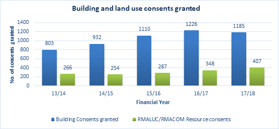
Figure 1: Building and
land use consent numbers by financial year. The above resource consent data is
sourced from MFE’s National Monitoring System.
2.1.2 Number of resource consents granted
Examining the number of resource
consents granted in a certain time period gives us an indication of the
development that is occurring within the District. Figure 2 shows the number of resource consents
granted in each of the financial years within the reporting period, and is
broken down into land use consents, subdivisions and combined applications.
Both land use and subdivision consent numbers have risen from the 2013/14
period to the 2017/18 financial year. Overall, consent numbers have increased
in this time from 471 consents granted in 2016/17, to 542 granted consents in
2017/18, and this represents a general upwards trend in consent numbers in the
past 5 years. An increase in consents granted may indicate increased
development in the District and a positive market for development, however may
also represent other factors such as development occurring in areas that are
not anticipated by the Plan or that the current provisions are restrictive for
the types of activities that are occurring in these areas. Therefore, it is
important to analyse consent location in order to gain an understanding of the
trends which are occurring.


2.2 Resource
consent location analysis
Analysing resource consents based on
their zone locations gives us an indication of where development is happening
within the District, but also shows the thresholds for activities within these
zones. The below graph (Figure
3) shows the number
of resource consent issued by zone over the current reporting period
(2013-2018). The below graph includes subdivision, land use and combined
resource consents.
As shown below, a large portion of
granted resource consents have occurred in the Rural Production zone, and more
broadly the rural environment (General Coastal, Coastal Living, Rural Living,
Rural Production and the Waimate North Special Zones) constitutes 70% of all
resource consents. Comparatively, the urban environment (comprised of
Commercial, Residential, Industrial, Coastal Residential and Russell Township
Zones) only makes up 30% of all resource consents. Of the 2268 applications, 1598 were in
the rural environment and 670 were in the urban environment. The Rural
Production zone alone accounted for 34% of all applications. This shows that development that
requires a resource consent has been directed to the rural environment. This
could be a result of growth not occurring where the plan anticipated and
infrastructure supply issues such as in Kerikeri urban area may be restraining
development until the new Kerikeri wastewater system is completed. It may also
indicate we have inadequate supply of urban zoned 
 land.
land.
The
below graph (figure 4) shows the location of resource consents broken down by
Far North communities. The majority of consents were issued
in the Kerikeri community (1,106 consents granted, or 45.22% of total consents)
and Northern communities (672 consents, or 27.47%) reflecting known trends of
growth in the districts eastern and northern areas. This trend is similar to
that of the previous reporting period.


An
analysis of the numbers of resource consents granted in suburbs across the
district over the 5 year reporting period was undertaken. Figure 5 identifies where the majority of
consented activity is occurring. Kerikeri had 558 consents issued, being 22% of
all consents received over the reporting period. The other four locations made
up 35%, therefore the top five locations alone accounted for more than half of
all development in the district. This shows that there is significantly more
development in the Kerikeri and surrounding areas (Waipapa and Kapiro), whereas
in the previous reporting period the top 5 locations in order were Kerikeri,
Kaitaia, Russell, Paihia and Karikari Peninsula.
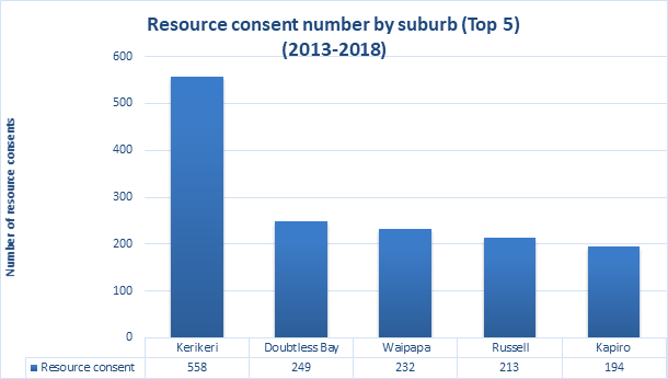
Figure 5: Number of resource consents by suburb
2.3 Resource
consent processing
Table
1 shows the
percentage of resource consents processed within statutory timeframes, as well
as giving an indication of the usage of Section 92 requests for further
information and section 37 extensions of time.
The
table shows that the number of consents being processed on time has decreased
over time with the use of section 92 between 35-44% and use of section 37
between 13-20%. Some of the reasons for the use of section 37 include time to
allow further consultation or getting technical input. The use of section 92
requests has remained relatively consistent throughout the reporting period,
however the number of consents processed within statutory timeframes has
decreased significantly from the 2016/17 financial year to the 2017/18 year.
This decrease may be due to a number of reasons including internal resourcing
issues, however may also be due to an increase in resource consent applications
received and may indicate a higher level of development in the District.
Table
1 – Resource consent processing, use of s92 and use of s37 statistics,
2014/2015-2017/2018
|
|
Processed within timeframes
|
Use of s 92
|
Use of s 37
|
|
2014/2015
|
99%*
|
44%*
|
18%*
|
|
2015/2016
|
94%*
|
39%*
|
18%*
|
|
2016/2017
|
89%*
|
35%
|
20%
|
|
2017/2018
|
32%*
|
39%
|
13%
|
*Resource consents data sourced from
MFE national monitoring system
2.4 Resource
consent costs
Figure 6 below highlights the average costs
for RMACOM, RMASUB and RMALUC consents on average cost $2,209; subdivision
consents cost $2,459 and combined consents costs $3,261.
The previous reporting period showed average costs of
$2,000 for land use consents, $2,225 for subdivision consents and $3,650 for
combined land use and subdivision consents. Due to the recent decrease in the
number of consents being processed on time, the discounting regulations would
be playing a significant part in the cost of consents
Fees are charged at the time of application of resource
consent, and in most instances are a deposit. The fees and charges below are
the current fees, and over the last 5 years there hasn’t been much of a
fee increase, which may explain why they deposit for RMALUC and RMASUB
applications don’t reflect the end cost.
Table 2 – Far North District Council Fees and
charges 2018-2019 year
|
Type of consent
|
Fees and charges
|
|
Fast track consent
|
$1073
|
|
Land
use consent
|
$1850
|
|
Subdivision consent
|
$1850
|
|
Combined
land use and subdivision consent
|
$3217
|
|
Deemed permitted boundary activities
|
$460
|
a)
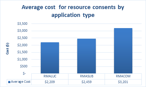
Figure 6:
Average costs for resource consents between 2013 and 2018
2.5 Deemed
Permitted Boundary consents
The
deemed permitted boundary rule came into effect 18 October 2017. To be deemed
permitted all neighbours with the ‘infringed boundaries’ must
provide written approval of the activity, and the only rules breached must be
relating to a boundary rule within the District Plan.
Figure
7 shows that
deemed permitted boundary applications were predominantly in the rural
production zone with 67% of all applications being in this zone. Figure 8 shows
that 78% of all applications related to a setback breach.
 Figure 7
- Deemed Permitted boundary applications issued by zone 2017-2018
Figure 7
- Deemed Permitted boundary applications issued by zone 2017-2018
Figure 8 - Deemed Permitted boundary
application by breach type 2017-2018
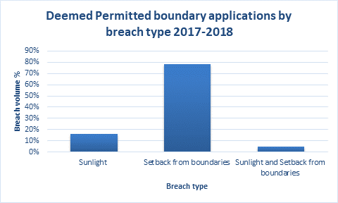
2.6 Designations
Since 2013 there have been 18
applications for designations. These predominantly came from the following
requiring authorities, Top Energy, Ministry of Education, and Far North
District Council. A full list of plan updates can be found in the plan changes update
schedule on the Far North District Council website.
3. Environment
trends and analysis
The following section outlines the
performance of the plan referring to resource consent trends in each of the
urban, rural and coastal environments. This provides an insight into the
efficiency and effectiveness of the operative plan.
3.1 Urban
environment
The
urban environment is made up of Residential, Commercial, Industrial, Coastal
Residential and Russell Township zones. This area accounts for 2,303ha of the
district’s 666,000 hectares. A
permissive approach to development has led to impacts on urban character,
amenity and infrastructure provision and created incompatible land uses.
In many instances the market has chosen to undertake commercial and industrial
activities on unserviced rural land due to lower costs and minimal regulation.
This has resulted in an inefficient use of existing infrastructure. This has
made infrastructure planning and deployment difficult to forecast and undertake.
A
detailed assessment of the urban environment expected environmental outcomes
and a cost benefit analysis of the rules can be found in the Section 35 report
2015 (Appendix C).
Resource Consent Analysis
Figure
9 shows resource
consents from 2013-2018 located in the Urban Environment. This is a total of
450 resource consents. In the Residential Zone there were 289 consents, in the
Industrial Zone there were 50, and in the Commercial Zone there were 111. Land
use consents made up the majority of applications accounting for 74%, whilst
subdivision consents made up 18%. The remainder is made up of combined resource
consent; there will also be a small number of other consent application types.
There
were less subdivision consents in the residential and commercial zones than the
previous reporting period and less land use consents across all zones.
Figure 9 - Urban Environment Resource
Consents by application type by zone 2013-2018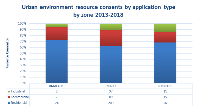
Since
2013, the Urban Environment has consistently had more land use consent
applications as opposed to subdivision consent applications. With reference to Figure
9 above, it is noted that the majority of both land use and subdivision
consents occurred in the Residential Zone as opposed to the Commercial and
Industrial Zone. Trends suggest that both subdivision and land use consents
will continue to reduce over time. Changes in the serviceability of our urban
environments such as the completion of the Kerikeri Wastewater project and
tightening up of subdivision of rural land could influence these figures.
Figure 10 - Urban Environment
Resource consent application type 2013-2018
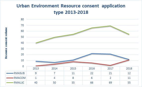
In
general subdivision signals new development and growth and it is closely aligned
with the prevailing economic climate. As the economy slows there is less
impetus for growth. However, although subdivision consents have slowed since
2017, there has been a steady flow of land use consents suggesting that
activities such as infill development, additions/alterations, and changes of
use activities have still occurred.
Resource consent locations
Figure
11 below highlights
where resource consents have been issued throughout the district. Using a total
sample of 2529 applications between 2013-2018. The majority of consents were in
Doubtless Bay and Kerikeri. Other Eastern and Northern ward suburbs also
featured heavily. Western ward activity is noted as being considerably lower,
although Kaikohe still had 23 resource consent applications over the period.
This data further clarifies trends seen in the previous reporting period
regarding growth in the Eastern and Northern wards in the District as opposed
to the Western ward.
Figure 11 -
Urban
Environment resource consent application type by suburb 2013-2018
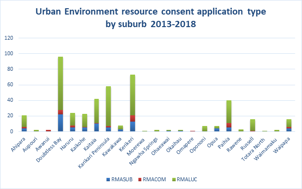
Figure 12 below shows the activity status of
resource consents in the urban environment out of the total sample of 354
applications that had complete data. Of the total residential consents 51% had
a discretionary status. In most instances this activity status would have been
triggered because applications failed to comply with one or more of the
standards for permitted, controlled or restricted discretionary activities.
Only 3% of all consents in the urban environment had a non complying status.
Figure 12 -
Activity status of resource consents in the urban environment 2013-2018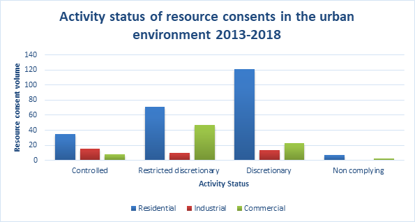
Notification
Out of 390 urban
environment applications 6 were limited notified all were not heard. The lack
of notified applications suggests that the breaches to the controls in the
urban environment incurred no more than minor effects on the environment,
affected parties gave their approval and the breaches were not significant.
Breach Analysis
Figures
13 - 15 below
provides greater detail by identifying whether land use consents for each of
the zones have been growth related (i.e. and increase in scale of a building),
or technical (i.e. greater parking requirements as a result of a change of
use).
Figures
13 -15 breach data
for the urban environment included a total of 606 breaches to the relevant
rules for the urban environment. This data assists in determining whether rules
most commonly breached are the most efficient and effective means of meeting
the relevant policies, objectives and environmental outcomes expected.
Figure 13
– Breach type in the residential zone 2013-2018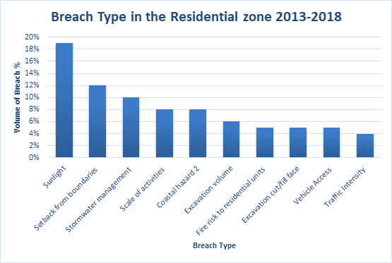
Of the sample of 606 breaches with
complete information, 393 related to the Residential Zone. Breaches of Sunlight
(19%) and Setback from Boundaries (12%) rules were the most common breaches
followed by stormwater management (10%), scale of activities (8%) and
Coastal hazard 2 (8%). Where as in the previous reporting period scale of
activities breaches featured as the top breach in this zone.
Figure 14 -
Breach type in the Commercial zone 2013-2018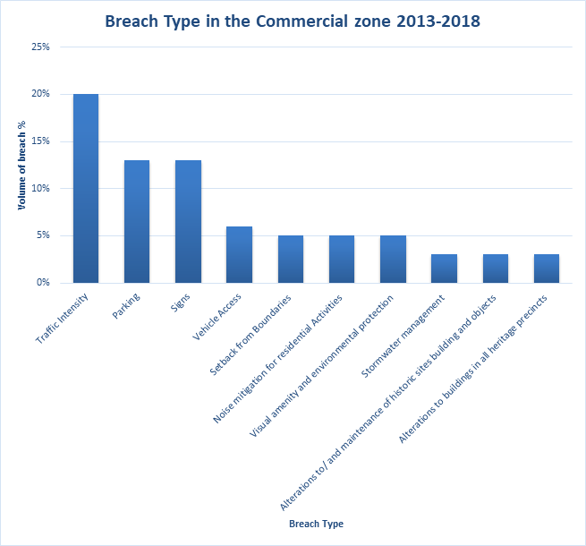
Of
the sample of 606 breaches, 143 related to the Commercial Zone. Figure 14
shows that the majority of consents were related to traffic intensity (20%),
parking (13%), and signs (13%). These results are similar to that of the previous
reporting period.
With
respect to the Traffic Intensity rule, these breaches related to activities and
their scale generating more than expected traffic movements. In terms of
parking, these breaches related to activities which proposed less than the prescribed
parking numbers for an activity.
Figure 15
– Breach type in the Industrial Zone 2013-2018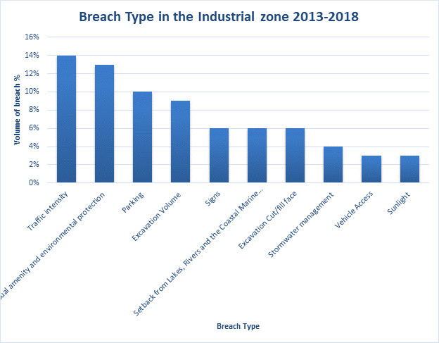
Of
the sample of 606 breaches, 70 related to the Industrial Zone. Breaches related
to traffic intensity (14%), visual amenity and environmental protection (13%),
parking (10%) and excavation volume (9%). The traffic and parking related
breaches are similar to that of the previous reporting period, yet breaches of
the visual amenity and environmental protection rule is a new occurrence as
applications seem to be lacking in consideration of landscaping.
3.2 Rural
Environment
The
majority of land within the District is in the Rural Environment and is used
for primary production, conservation, commercial and rural living. A relatively
permissive planning framework has led to land fragmentation, reverse
sensitivity and lot size that promote residential development. The reduction in
production potential is economically significant when subdivision occurs on
highly productive land.
Key
observations relating to the internal consistency of the Rural Living and Rural
production zone are considered in the section 35 report 2015 ( Appendix C).
Resource consent analysis
The
Rural environment resource consent analysis used a sample size of 1033
consents. Figure 17 shows resource consents from 2013-2018 located in
the Rural Production and Rural Living zones, the predominant consent type was
RMALUC (45%). Historically there has been more subdivision activity as opposed
to land use activity. This changed between 2016 and 2017 were we saw
growth in land use applications before a trend of decrease more recently.
Figure 16 - Rural
Environment zone resource consents by application type 2013-2018
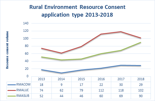
Figure 17 below uses a total sample of
1033 consents. Most of the consents were in the Rural Production zone 71%, with
large volumes of both subdivison and land use consents.
Figure 17- Rural environment resource
consents by application type by zone 2013-2018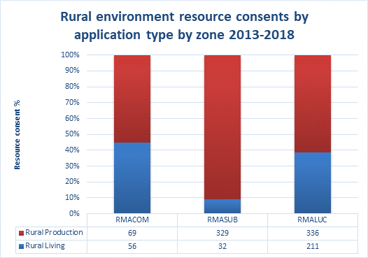
Resource consent activity status
Figure 18 shows the activity status of the 807 consent with a
recorded activity status in the rural environment. Most of the rural
production consents had an activity status of restricted discretionary (43%).
Most of the rural living consents had a discretionary activity status (52%). In
most instances this activity status would have been triggered because
applications failed to comply with one or more of the standards for permitted,
controlled or restricted discretionary activities.
Figure 18- Activity status
of resource consents in the rural environment 2013-2018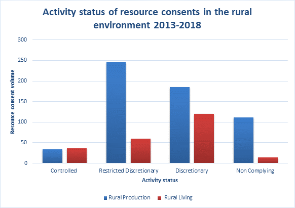
Notification
Of the
analysis of 916 rural environment resource consents between 2013-2018, only 3
were notified and heard with a further 9 notified but not heard. This is 1.3%
of the resource consents. The limited number of notified application
suggests that the breaches incurred no more than minor effects on the
environment.
Rural Living consents location analysis
Figure
19 below highlights
where resource consents have been issued throughout the district. The majority
of consents were issued in the Kerikeri and Northern Communities. A fair
proportion of all Rural Living Zone land is located in these areas as opposed
to the Kaikohe, Kawakawa, and Hokianga Communities where activity and zoned
land is lower. The figures mirror the Urban Environment development trends
which highlight similar trends. This reflects similar trends shown in the
previous reporting period.
Figure 19 - Rural Living
resource consent application type by community 2013-2018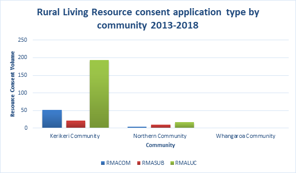
Breach Analysis
A
sample of resource consents for the rural living zone included a total of 408
rule breaches to the Plan. This assessment helps to understand whether land use
consents have been growth related i.e and increase in scale of a building, or
technical i.e greater parking requirements as a result of a change of use.
Figure 20 – Breach type in the
Rural Living zone 2013-2018
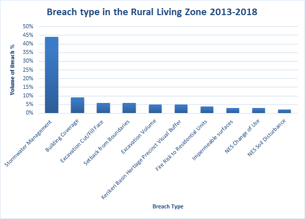
Figure 20 above shows breaches to the
Stormwater Management rule accounted for 44% of the rule breaches within the
Zone over the sample. Other frequent breaches included building coverage. In
the pervious reporting period impermeable surface breach was the most prominent
but this is essentially the same breach as the rule was changed to stormwater
management through Council Plan change 17.
In the sample of resource
consents for the Rural Production zone which included a total of 464 rule
breaches to the Plan. This assessment helps to understand whether land use
consents have been growth related i.e and increase in scale of a building, or
technical i.e greater parking requirements as a result of a change of use.
Figure
21 - Breach type in the Rural Production zone 2013-2018
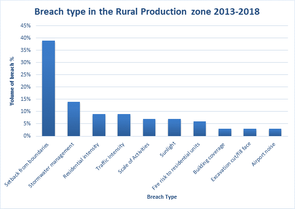
Figure 21 shows breaches to the setback from
boundaries accounted for 39% of the rule breaches within the zone over the
sample. Other frequent breaches included stormwater management, followed by
residential intensity and traffic intensity.
Plan change 15
An
analysis was conducted to see if there were any trends as a result of plan
change 15, where there was the introduction of the minor household unit rule,
introduction of scale of activities rule, a permitted temporary events rule and
a decrease in the traffic intensity thresholds.
The
introduction of the scale of activities rule has seen 33 resource consent
applications since 2015 most of these had additional rule breaches so would
have required resource consent regardless. Some of the activities applied for
under this rule include the Kerikeri Pack house markets, accommodation
facilities, a gospel hall, concert events, cafes, commercial sheds and a
landscaping depot.
There
has been 8 resource consents applications for traffic intensity breaches with
state highway addresses since 2015 without further detailed analysis of the
consents it hard to determine if they would have been picked up with out the
traffic threshold changes.
The
introduction of the minor residential unit controlled rule has seen 20
applications under this rule, with one application being rejected due to the
application being incomplete. Fourteen of those applications were in the
Kerikeri and surrounds areas.
3.3 Coastal
Environment
The
coastal environment in the Far North is vast and complex and covers
approximately 82,500 hectares, as defined by the Regional Policy Statement.
There is a conflict between the need to preserve and protect the natural
character of the coastal environment and provide for appropriate access and
development. A continued pattern of settlement near the coast has placed
additional pressure on coastal resources and amenity.
Resource Consent Analysis
Since
2013, the Coastal Environment (Coastal Residential, Coastal Living and General
Coastal zones) has consistently had more land use consent applications issued
compared with subdivision consent applications. In general subdivision signals
new development and growth and it is closely aligned with the prevailing
economic climate. As the economy slows there is less impetus for growth.
However, despite subdivision consents slowing in 2014 then climbing in 2015
they have remained steady over the last few years. There has been a steady flow
of land use consents which suggests that activities such as infill development,
additions/alterations, and changes of use have still occurred over that period
as shown in Figure 22.
Figure 22 – Coastal Environment Resource Consent by
application type 2013-2018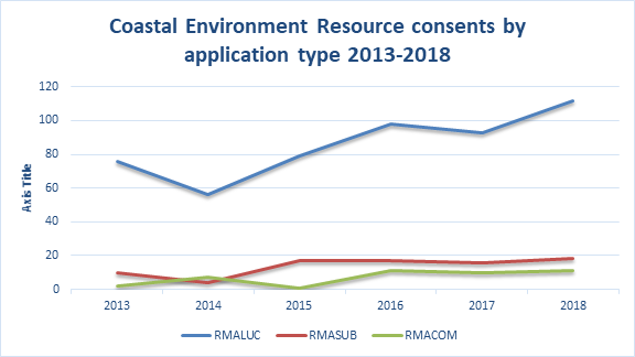
Figure 23 shows the Coastal Living
zone has significantly more land use consent applications. Of the sample of 649
consent applications, 267 (41%) were for breaches in the coastal living
zone. All zones had similar subdivision consent applications. This is a
similar trend to the previous reporting period.
Figure 23 – Coastal
environment resource consent application type by zone 2013-2018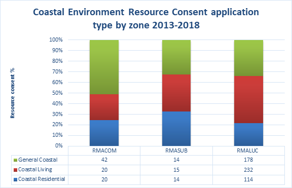
Activity Status Analysis
Of
the resource consents in the sample that required consent, over 51% of them
were discretionary activities. In most instances this activity status would
have been triggered because applications failed to comply with one or more of
the standards for permitted, controlled or restricted discretionary activities
as seen in Figure 24. These figures are similar to that of the previous
reporting period. 23 (5%) of the consents in all zones had a non complying
status this figure was considerably lower compared to 16% in the previous
reporting period.
Figure 24 – Activity
Status of Consents in the Coastal Environment 2013-2018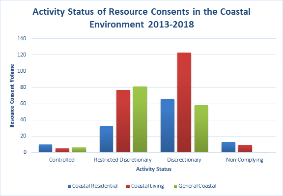
Notification
Of
the 551 coastal environment resource consent applications between 2013-2018, 8
applications were limited notified (1.4%) with 3 of these being heard. The lack
of notified applications suggests that the breaches to the controls as they
relate to the coastal environment incurred no more than minor effects on the
environment, or written approval was given by those affected.
Breach Analysis
The
breaches identified in the figures below may help us better understand the
nature of the land use consent applications since 2013 and whether they have
been growth related i.e an increase in scale of a building, or technical i.e
greater parking requirements as a result of a change of use. Figures 25
– 27 identify a total of 1186 breaches to the relevant rules in the
Plan from the time records area available (2013 – 2018). This data may
assist in determining whether rules most commonly breached are the most
efficient and effective means of meeting the relevant policies, objectives and
environmental outcomes expected.
Figure 25 -
: Breach type in the coastal living zone 2013-2018 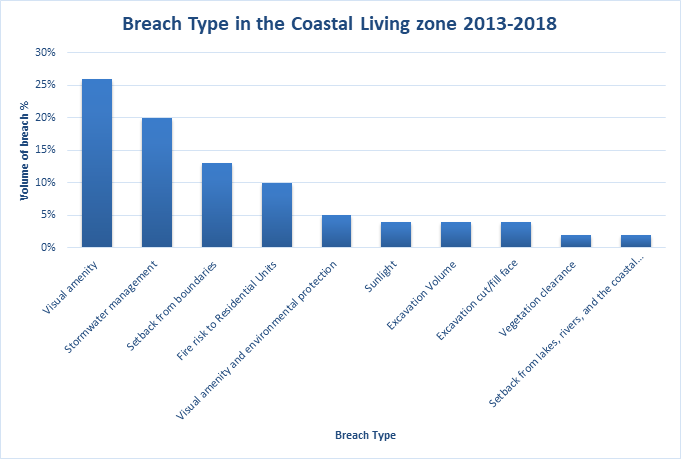
Figure 25 shows of the sample of 1186 breaches,
542 related to the Coastal Living Zone. Breaches of Visual Amenity were
the most common at 26% followed by Stormwater Management (20%), and Setback
from Boundaries (13%). The nature of the breaches suggests that the degree of
development was greater than that envisaged by the provisions in the Plan. Most
of the Visual Amenity breaches related to buildings where, as a permitted
activity, control over a new building as a permitted activity is limited to 50m2
and any alteration/addition is limited to a 30% in addition to that which currently
exists. For the previous reporting period visual amenity breaches also
came out on top along with impermeable surfaces, which was replaced by the
stormwater management rule through Council plan change 17 – Impermeable
surfaces.
Figure 26
– Breach Type in the Coastal Residential Zone 2013-2018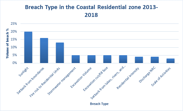
As shown in Figure
26 of the sample of 1186 breaches, 230 related to the Coastal Residential
Zone. The majority of consents were related to Sunlight breaches (20%) and
Setbacks from Boundaries (16%) followed by Fire Risk to Residential Units
(13%). The nature of these breaches suggests that new dwellings or
additions/alterations are struggling to remain in the confines of the site and
are therefore impinging on the sunlight and setback controls. These results are
similar to that of the previous reporting period.
Figure 27
– Breach Type in the General Coastal zone 2013-2018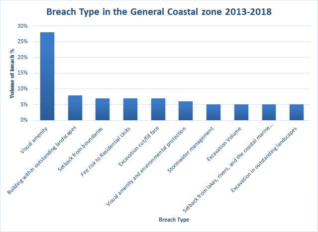
As shown in Figure
27 of the sample of 1186 breaches, 414 related to the General Coastal Zone.
Breaches of Visual Amenity were by far the most common at 28% followed by
building within Outstanding Landscapes (8%). Most of the Visual Amenity
breaches related to buildings where, as a permitted activity, control over a
new building as a permitted activity is limited to 50m2 for un
inhabited building or 25m2 for human habitation. Any
alteration/addition is limited to a 30% in addition to that which currently
exists. The top breach in the previous reporting period was also visual
amenity.
4. District
wide reporting
This section identifies some of the
key district wide trends which helps to detail the efficiency and effectiveness
of the operative plan.
Detailed analysis of all district wide
topics can be found in the Section 35 report 2015 (Appendix C).
4.1 Tangata
Whenua
Tangata Whenua play a large
role in the Far North District. Māori make up 43% of our district’s
population and own approximately 17% of the land in the Far North District.
There are eleven Mandated Iwi Organisations for the purposes of the RMA and a
number of Iwi and Hapū who have lodged Iwi/Hapu Environmental Management
Plans with Council. There are six Iwi in our district who have Treaty of
Waitangi Settlement legislation, Te Roroa, Ngāti Kuri, Te Aupouri,
NgaiTakoto ,Te Rarawa and Ngātikahu ki Whangaroa.In addition to this
Ngāpuhi, Ngāti Hine and numerous Hapū have entered into
theTreaty of Waitangi Tribunal process and are the beginnings of the settlement
process. It is within this context and the context of Māori as developers
and Tangata Whenua as kaitiaki that Tangata Whenua is considered to be a
significant resource management issue in the District.
A detailed audit of the
plan performance through a Māori lens can be found in the Section 35
report 2015 (Appendix C).
Table 3 -
– Papakāinga Housing and Integrated Development resource consents
2013-2018
|
|
R/C
|
Zone
|
Rule
|
Activity Status
|
Date Approved
|
Address
|
Description
|
|
1
|
2130203
|
Rural Production/ Residential
|
Residential – 7.6.5.1.11 TIFs,
7.6.5.1.1 Relocated buildings. Rural Production – 8.6.5.4.2 Integrated
development. District Wide – 15.1.6.1.2 Vehicle Access, 12.3.6.1.3
Excavation and filling.
|
Discretionary
|
24 July 2013
|
23 Kohuhu Street, Kaitaia
|
Relocation 6 dwellings onto a site. Three
existing houses are located on the site which form part of the multi stage
affordable housing project.
Note: the Rural Production part of this
application was applied for under the Integrated Development rule, the rule
does not apply in the Residential zone. The He Korowai Trust changed general
land to Māori land in order to be able to use this rule.
Note: This application was limited notified
and went to hearing and was approved by the Hearing Commissioner
|
|
2
|
2140207
|
Rural Production
|
8.6.5.2.2 PAPAKAINGA HOUSING
|
Controlled
|
12 Feb 2014
|
Ngakaroa Rd, Ahipara
|
To construct an additional 3 rammed earth
dwellings as part of a Papakainga Development in the Rural Production Zone
|
|
3
|
2150101
|
Rural Production
|
8.6.5.4.2
INTEGRATED DEVELOPMENT
|
Discretionary
|
24 Dec 2014
|
Potahi Road, Te Kao
|
To establish 12 additional residential
units in two stages within an existing Papakainga Development in the Rural
Production Zone under rule 8.6.5.4.2 ‘Integrated Development’ of
the District Plan.
|
|
4
|
2160124
|
Rural Production/ General coastal
|
8.6.5.3.1 TIFFs
|
Restricted discretionary
|
02 Oct 2015
|
203A Te Ra Road, Kerikeri
|
Relocate a dwelling onto papakainga whenua
|
|
5
|
2160246
|
Rural Production
|
8.6.5.1.5 Traffic Intensity
8.6.5.1.1 Residential Intensity
|
Discretionary
|
2 Feb 2016
|
203A Te Ra Road, Kerikeri
|
Construct a residential unit
Note: Resource consent RC21100303,
currently lodged with Council (but suspended), sought to create a Papakainga
development within the block under the Integrated Development rule, however
consent has not progressed for several years. Each applicant who would
like to construct a dwelling on the block therefore needs to apply for
resource consent individually
|
|
6
|
2160262
|
Rural Production
|
8.6.5.2.2 Papakainga Housing
|
Controlled
|
17 Feb 2016
|
2286 West Coast road, Pangruru
|
Construct an additional three dwellings o
the site as a papakaianga development. The site already contains 4 dwellings
and a fifth dwelling partially completed
|
|
7
|
2170135
|
Rural Production
|
8.6.5.1.5 Traffic Intensity
8.6.5.1.1 Residential Intensity
|
Discretionary
|
29 Sept 2016
|
203A Te Ra Road, Kerikeri
|
New dwelling on papakainga land
|
|
8
|
2160340
|
Rural Production
|
8.6.5.4.2 Integrated Development
|
Discretionary
|
3 Nov 2016
|
206 Rangihamama Road, Kaikohe
|
Proposed Papakainga housing development
consisting of 15 houses with associated roads, stormwater disposal, waste
water treatment and disposal and landscaping by way of an integrated
development plan.
|
|
9
|
2180402
|
Rural Production/ Residential
|
Residential – 7.6.5.1.1 Relocated
buildings, 7.6.5.1.2 Residential Intensity 7.6.5.1.11 TIFFs. Rural Production
– 8.6.5.1 Residential Intensity, 8.6.5.1.11 Scale of activities.
8.6.5.4.2 Integrated development
|
Discretionary
|
2 Feb 2018
|
23 Kohuhu Street, Kaitaia
|
To carry out stage two of project
“Whare Ora” by establishing 9 relocatable dwellings, 2
relocatable former classroom blocks to be used as a Trades Training Academy,
a temporary ablution block and a temporary office block to oversee the
construction project. Site is ‘Māori Freehold land’
|
|
10
|
2180534
|
Rural Production
|
8.6.5.4.2 Integrated development
12.4.6.3 (a) & (c) Fire risk to residential units
|
Discretionary
|
12 April 2018
|
1345 Orakau Road Kaikohe
|
Construct a residential dwelling
|
Between 2013 and 2017 there were 10
resource consent applications under the Papakāinga Housing and Integrated
Development rules in the Far North District Plan. Eight applications have been
made under the Integrated Development rule and two under the Papakāinga
Housing rule. Eight of the ten application were non notified, with two being
limited notified. All of the applications were in the Rural Production zone.
4.2 Outstanding
natural landscapes and features
Approximately
21% of the District is covered in outstanding natural landscapes (ONL) and 1.5%
in outstanding natural features (ONF). While a large portion is on land
administered by the Department of Conservation, approximately 20% of Māori
owned land in the district is covered by an ONL and/or ONF. In the Plan they
are simply referred to as Outstanding Landscapes. There is conflict between the
requirement to protect landscapes and features and a perceived cost to private
land owners in terms of their ability to develop. The regulatory intervention
applied to the protection from inappropriate subdivision, use and development
does not acknowledge the statutory tensions with respect to enabling Māori
to continue to enjoy the relationship they have with their ancestral lands
Section
35 report 2015 (Appendix C) includes a detailed analysis of the current
provisions
Resource consent analysis
A
total of 66 resource consents were received in relation to Outstanding Natural
Landscapes and Features between 2013-2018. Figure 28 below further
details in what zones those resource consents were received. The majority of
applications were either in the General Coastal zone or the Rural Production
zone. As can be seen in the graph below there was a peak of resource consent
applications issued in 2013, from then there has been a steady decline leading
up to 2015, followed by and increase in recent years.
Figure 28
– Outstanding Natural Landscape and features Resource Consents 2013-2018
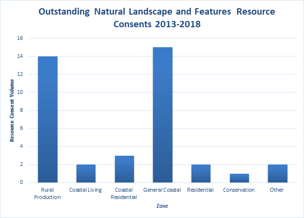
Figure 29 shows that the number of Outstanding
Natural Landscape and Features consents was declining in the early part of the
recording period, followed by an upwards trend. The previous reporting period
showed a trend of decline in Outstanding Landscape consents between 2011-2015.
Figure 29
– Outstanding Natural Landscapes and features Resource Consents Issued
2013-2018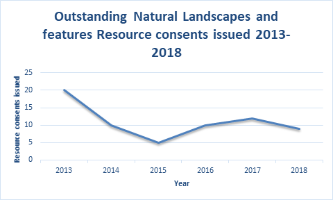
Breach Analysis
The
breaches identified in Figure 30 below may help us better understand the
nature of the land use consent applications since 2013. Figure 30
identifies a total of 89 breaches to the relevant rules in the Plan from the
data available 2013-2018. This data may assist in determining whether rules
most commonly breached are the most efficient and effective means of meeting
the relevant policies, objectives and environmental outcomes expected.
Figure 30
– Breach type for outstanding landscapes 2013-2018
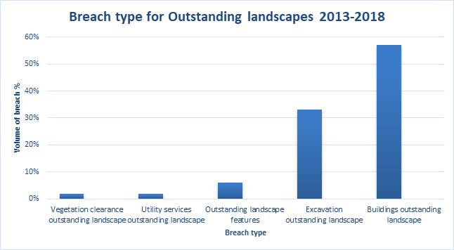
Of the sample of 89 breaches, 57 %
related to buildings in outstanding landscapes, and 33 % related to excavation
in outstanding landscapes. The most common breach in the previous reporting
period was buildings within outstanding landscapes.
Activity Status Analysis
The
nature of the breaches suggests that the degree of development in these
outstanding areas was greater than that envisaged by the provisions in the
Plan. While visual amenity is not a standard addressed in the Outstanding
Landscape rules, it is picked up along with breaches relating to buildings
within Outstanding Landscapes in the General Coastal zone. Where this happens
the non habitable threshold for buildings reduces to 25m2 and
resource consent is required for a habitable dwelling. It therefore is understandable
that this is a common breech of the controls as most buildings will require
resource consent within an Outstanding Landscape.
Figure 31
– Activity status of outstanding landscape resource consents 2013-2018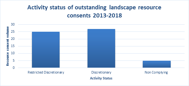
Of
the resource consents that required consent 47% of them were discretionary
activities. Discretionary activities are activated in the Plan within
Outstanding Natural Landscapes where applications fail to comply with one or
more of the standards for permitted, controlled or restricted discretionary
activities. Compared to the previous time period more of the consents have a
restricted discretionary status.
Notification
Understanding
the approach to notification is an important factor because it has a direct
bearing on the level of third party involvement and cost of the resource
consent process, but more importantly investment and development behaviour with
respect to the Plan. Of the 67 consents that were issued over this period none
were notified. In the previous reporting period 2 resource consent applications
were notified.
The
lack of notified applications may suggest that the breaches to the controls as
they relate to Outstanding Natural Landscapes incurred no more than minor
effects on the environment. Also effects in these landscapes are not normally
on neighbours, which is a common reason for going to a hearing, effects are
also offset by conditions e.g landscaping or colours.
4.3
Indigenous Flora and Fauna
The
Far North District has a land area of around 666,000 hectares. Approximately
267,000 hectares of that area (around 40%) comprises of indigenous habitat. Due
in part to the relatively large area of indigenous habitat remaining, but also
due to the district’s unique geology, the Far North retains a diverse suite
of ingenious ecosystems and is host to a large variety of native plants and
animals, many of which are found only in the Northland area. Council has
recently undertaken a mapping project in conjunction with Whangarei and Kaipara
District Councils to identify Significant Natural Areas (SNAs) within the
region. In the Far North, it has been identified that there are 685 individual
SNAs, covering 282,696
hectares (or 42% of the District). The below table (sourced from the 2019
Wildlands SNA report), shows the breakdown of vegetation types in the Far
North.
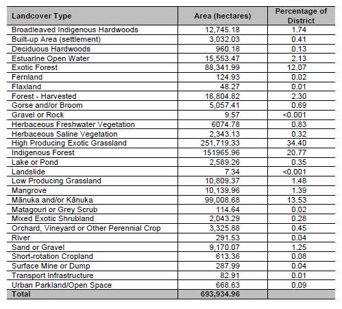
The
SNAs have been identified through a desktop analysis, however will be
groundtruthed in the latter half of 2020. The SNAs were defined as such using
the significance criteria in Appendix 5 of the Regional Policy Statement for
Northland, which requires territorial authorities to undertake the
identification of SNAs. The SNA mapping project will assist in informing the
indigenous biodiversity chapter in the proposed District Plan.
Covenants
The
number of QEII open space covenants has increased from 187 in 2008 to 211 in
2018. The number of hectares of land covenanted increased from 5171 ha to 5373
ha. The current make up of vegetation type protected is detailed in Table 4
below:
Table 4 - Bush / cover type of QEII
open space covenants 2018
|
Bush/cover type
|
Total
|
|
Broadleaved Indigenous Hardwoods
|
448.6
|
|
Built-up Area (settlement)
|
0.9
|
|
Deciduous Hardwoods
|
4.9
|
|
Exotic Forest
|
140.8
|
|
Fernland
|
0.0
|
|
Forest – Harvested
|
1.6
|
|
Gorse and/or Broom
|
13.6
|
|
Herbaceous Freshwater Vegetation
|
234.3
|
|
Herbaceous Saline Vegetation
|
5.3
|
|
High Producing Exotic Grassland
|
445.3
|
|
Indigenous Forest
|
2605.1
|
|
Lake or Pond
|
6.9
|
|
Low Producing Grassland
|
14.7
|
|
Mangrove
|
11.9
|
|
Manuka and/or Kanuka
|
1437.3
|
|
Orchard, Vineyard or Other Perennial Crop
|
1.5
|
|
Sand or Gravel
|
0.1
|
|
Short-rotation Cropland
|
0.0
|
|
Urban Parkland/Open Space
|
0.2
|
|
Grand Total
|
5373.2
|
FNDC
has implemented a policy (# R04/11) to allow for the remission of rates on land
subject to protection for outstanding landscape, cultural, historic or
ecological purposes. The policy was implemented to give effect to Method
12.2.5.13 of the Plan, which sets out that FNDC will allow for the remission or
postponement of rates in areas afforded permanent legal protection through a
covenant or reserve status. As of 2018 there are 88 covenants with 1446ha of
land protected.
Vegetation Clearance
The
overall national trend over the last decade has been one of biodiversity
decline, and the Far North is no different. However, the SNA mapping project
shows that there are still significant tracts of indigenous vegetation in the
Far North. Table 5 shows vegetation loss between 2008 and 2018, from
Landcare’s national vegetation clearance database.
Table 5- Vegetation loss between 2008
and 2018, including breakdowns of vegetation type
|
LUCID
|
LUC_NAME
|
% change
between 2008 & 2016
|
Change in
hectares between 2008 & 2016 (ha)
|
% change
between 2008 & 2018
|
Change in
hectares between 2008 & 2018 (ha)
|
% change
between 2012 & 2016
|
Change in
hectares between 2012 & 2016 (ha)
|
|
71
|
Natural
Forest
|
-0.15%
|
-375.1
|
0.65%
|
1,577.3
|
-0.05%
|
-111.4
|
|
72
|
Planted
Forest - Pre-1990
|
-0.70%
|
-626.1
|
-0.38%
|
-338.7
|
-0.29%
|
-256.0
|
|
73
|
Post 1989
Forest
|
1.91%
|
435.6
|
-0.20%
|
-45.2
|
-0.05%
|
-11.5
|
|
74
|
Grassland -
With woody biomass
|
-0.61%
|
-282.0
|
-2.58%
|
-1,194.1
|
-2.17%
|
-1019.2
|
|
75
|
Grassland -
High producing
|
0.54%
|
1,199.8
|
0.23%
|
511.2
|
0.39%
|
868.2
|
|
76
|
Grassland -
Low producing
|
-1.25%
|
-334.9
|
4.40%
|
1,176.8
|
2.04%
|
527.5
|
|
77
|
Cropland -
Perennial
|
-1.16%
|
-38.2
|
-1.63%
|
-53.8
|
0.10%
|
3.4
|
|
78
|
Cropland -
Annual
|
2.54%
|
15.7
|
2.54%
|
15.6
|
0.00%
|
0.0
|
|
79
|
Wetland -
Open water
|
0.57%
|
22.3
|
-6.31%
|
-247.5
|
0.00%
|
0.0
|
|
80
|
Wetland -
Vegetated non forest
|
-0.64%
|
-88.2
|
-9.94%
|
-1,373.5
|
-0.11%
|
-15.8
|
|
81
|
Settlements
|
1.08%
|
40.5
|
-0.26%
|
-9.6
|
0.00%
|
0.0
|
|
82
|
Other
|
0.37%
|
30.7
|
-0.22%
|
-18.4
|
0.18%
|
14.8
|
|
|
Totals
|
2.5%
|
-745.4
|
-13.69%
|
-990.3
|
0.04%
|
-1146.4
|
Appendix A -
Effects Based Rule Thresholds
Current Effects Based Mechanisms
A matrix is provided in Table 1, comparing various relevant rule
thresholds across the Rural Environment; Rural Production & Rural Living
Zones, the special Waimate North Zone (within the rural environment, but with
special attributes), and comparing these with the Urban Environment; Commercial
and Industrial Zones, and the Coastal Environment General Coastal & Coastal
Living Zones. All the rules examined have a direct or indirect influence on
managing effects of land use incompatibility, cumulative effects and amenity
values.
Table 1 - Current Land Use Provisions
|
RULE
|
ZONE
|
|
Permitted threshold
|
Rural Production
|
Waimate North
|
General Coastal
|
Rural Living
|
Coastal Living
|
Commercial
|
Industrial
|
|
Residential
Intensity
|
1 residential unit per 12ha
|
1:4ha
|
1:20ha
|
1:4000m2
|
1:4ha
|
No rule
|
No rule
|
|
Visual Amenity [and
Environmental Protection]
|
No rule
|
No rule
|
Most buildings (whether residential or not)
require resource consent pursuant to a Visual Amenity rule.
|
No rule
|
Most buildings (whether residential or not)
require resource consent pursuant to a Visual Amenity rule.
|
Screening by way of landscaping, fences, walls
required where adjoining a zone other than Com or Ind; 50% of road boundary
to be landscaped
|
Screening by way of landscaping, fences, walls
required where adjoining a zone other than Com or Ind; 50% of road boundary
to be landscaped
|
|
Sunlight
|
2m + 450
|
2m
+ 450
|
2m
+ 450
|
2m
+ 450
|
2m
+ 450
|
2m
+ 450 where adjoining a residential, RL or CL zone
|
2m
+ 450 where adjoining a residential, RL or CL zone
|
|
Height
|
12m
|
10m
|
8m
|
9m
|
8m
|
10m; 8.5m or no limit, dependent on location
|
12m in Opua Industrial Zone, no limit elsewhere
|
|
Setback
|
10m; 12m along a section of Kerikeri Rd; 100m
where adjoining Minerals Zone
|
75m from specified road boundaries; 10m from other
site boundaries; reduced to 3m where sites are less than 4000m2 in
area
|
10m for sites larger than 5000m2 in
area; 3m elsewhere; 100m where adjoining Minerals Zone
|
Predominantly 3m; 10m where adjoining RP zone; 20m
where adjoining Minerals Zone; 12m along sections of Kerikeri Road
|
10m for sites larger than 5000m2 in
area; 3m elsewhere
|
6m & 10m variously in Paihia, dependent on
sub-zoning; no limit elsewhere
|
2m from State Highways, no limit elsewhere
|
|
Impermeable Surfaces
|
15%
of site, no maximum specified
|
15%
of site, or 5000m2, whichever is the lesser
|
10%
of site, no maximum specified
|
10%
or 3000m2, whichever is the lesser
|
10%
or 600m2, whichever is the lesser
|
No
rule
|
No
rule
|
|
Scale of Activities
Exemptions in every zone where this rule applies –
activities of a limited duration required by normal farming and forestry
practice
|
No
rule
|
8
persons per 4ha
|
4
persons per site; or 1 person per 1ha, whichever is greater
|
1
person per 1000m2
|
1
person per 2000m2
|
No
rule
|
No
rule
|
|
Permitted threshold
|
Rural
Production
|
Waimate
North
|
General
Coastal
|
Rural
Living
|
Coastal
Living
|
Commercial
|
Industrial
|
|
Permitted
threshold
|
Rural
Production
|
Waimate
North
|
General
Coastal
|
Rural
Living
|
Coastal
Living
|
Commercial
|
Industrial
|
|
Traffic
Intensity Exemptions in every zone – single residential unit,
farming, forestry and construction traffic
|
60
daily one way traffic or 30 if access is via a state highway
|
60
daily one way traffic or 30 if access is via a state highway
|
30
|
20
|
20
|
200
|
200
|
|
Screening for Neighbours – non-residential activities
|
No
rule
|
No
rule
|
No
rule
|
Outdoor
areas used for specified non-residential activities to be screened from
adjoining sites by landscaping, walls, fences or combination thereof
|
Outdoor
areas used for specified non-residential activities to be screened from
adjoining sites by landscaping, walls, fences or combination thereof.
|
No
rule, but see Visual Amenity & Environmental Protection above
|
No
rule, but see Visual Amenity & Environmental Protection above
|
|
Hours of Operation – non-residential activities
Exemptions in every zone where this rule applies –
activities that have a predominantly residential function such as lodges,
motels and homestays
|
No
rule
|
No
rule
|
No
rule
|
50hrs
per week; limited to between certain hours of the day
|
50hrs
per week; limited to between certain hours of the day
|
No
rule
|
No
rule
|
|
Keeping of Animals
|
50m
from site boundary; 600m from residential zone boundaries
|
Not
permitted
|
50m from site
boundary; 600m from residential zone boundaries
|
50m from site
boundary; 600m from residential zone boundaries
|
50m from site
boundary; 600m from residential zone boundaries
|
Not permitted
|
Not permitted
|
|
Noise
Exemptions in every zone – activities of a limited
duration required by normal farming and forestry practice
|
65
dBA day time
45
dBA night time
70
dBA max
|
55
dBA day time
45
dBA night time
70
dBA max
|
55
dBA day time
45
dBA night time
70
dBA max
|
55
dBA day time
45
dBA night time
70
dBA max
|
55
dBA day time
45
dBA night time
70
dBA max
|
65
dBA day time
45
dBA night time
70
dBA max
|
65
dBA day time
45
dBA night time
70
dBA max
|
|
Permitted threshold
|
Rural
Production
|
Waimate
North
|
General
Coastal
|
Rural
Living
|
Coastal
Living
|
Commercial
|
Industrial
|
Appendix C - Section 35 Report 2015

▪
Table of Contents
Executive Summary. 3
PART A.. 4
1. Purpose.. 4
1.2 Background.. 4
1.3 Methods. 6
PART B. 10
2 District Wide Analysis – Broad Development Trends. 10
2.1 Consenting Outcomes. 10
2.2 Subdivision and Development Activity. 11
2.3 Resource Consent Data. 13
2.4 Resource Consent Processing. 16
2.5 Resource Consent Costs. 16
3 Significant Resource
Management Issues. 18
3.1 Tangata Whenua
Policies: Methods and Expected Outcomes. 18
3.2 Urban Growth Management. 20
3.3 Rural Sustainability. 22
3.4 Heritage.. 24
3.5 Coastal Protection.. 25
3.6 Outstanding Landscapes. 28
3.7 Indigenous Flora and
Fauna. 31
3.8 Renewable Energy and
Energy Efficiency. 35
Part C. 37
4. Detailed Data. 37
4.1 Tanagata Whenua. 37
4.2 Urban Growth.. 40
4.3 Rural Sustainability. 50
4.4 Coastal Protection.. 55
4.5 Outstanding Landscapes. 63
4.6 Indigenous Flora and
Fauna. 67
4.7 Heritage.. 73
Appendix A - Effects Based
Rule Thresholds. 79
Appendix B - Key Dates,
Plan Changes. 82
The Far North
District Plan has acted as the District’s principal tool to achieve the
sustainable management purpose of the Resource Management Act 1991 (the Act)
for nearly 7 years.
Since the Plan
became fully operative in September 2009, after being made partly operative in
2007, the plan has acted to manage the effects of the use, development, and
protection of land and associated natural and physical resources. The District
contains some of the country’s most significant cultural and heritage resources,
a diverse and unique set of environments and the foundation elements for
economic, cultural and social well being for the District’s many
communities. In this light, the role of the District plan has particular
importance. The stakes are high.
The review of the
efficiency and effectiveness of the plan is a good opportunity to understand
the if the plan is achieving it’s ends and whether it does so in an
appropriate manner. The review also contributes to the platform of knowledge
that will be utilised for the review of the Far North District Plan (the
District Plan).
Appraisal of the
plan’s performance depends on a bank of data and feedback information
needs the monitoring mechanisms and feedback to inform. The plan suggests a
variety of means to collect this data and, due to resourcing constraints, and
other prioritized actions a complete data set has not been available. This has
necessitated that other means are utilised to understand the relative
performance of the plan. This includes the use of case studies, proxies and
representative sample sets of data.
Overall, the plan
performs the statutory role of sustainable management of natural and physical
resources efficiently and effectively. It has provided a stable framework for
integrated management of effects and responsiveness to resource management
issues.
The largely
effects based planning instrument has operated in a time where economic
conditions have fluctuated from a period of unprecedented growth, reflected in
a higher level of subdivision activity, to low growth and now a trend towards
growth in particular locations.
As an effects
based instrument, some of the actions and management approaches of the plan are
more direct, measurable and understandable. Whereas other provisions may be
difficult to evaluate in terms of efficiency and effectiveness. The former
includes siting and design provisions of the environment and sections of the
district wide provisions of the plan. The latter includes the relative
performance of the tangata whenua provisions of the plan, which are relatively
confined in the policy framework. Another aspect is the balance of the supply
and demand tensions that exist in the urban environment and at interface of the
urban environments.
More work is
required to ascertain the relative importance of some of these performance
measures in the context of a plan review, and identifying the most appropriate
future responses to existing and emergent resource management issues.
PART A
This
document reports on the efficiency and effectiveness[1]
of the Far North District Plan in accordance with Section 35 of the Resource
Management Act 1991 (RMA).
Section
35(2) of the RMA requires that all Councils gather information, undertake
monitoring and keep records to, amongst other things, enable the efficiency and
effectiveness of policies, rules, or other methods to be assessed.
There
are three parts to the report:
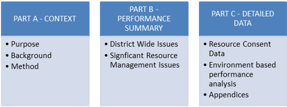 Parts A and B
convey the key information associated with the review and the outcomes of the
review process. Part C contains supporting information used to complete the
analysis.
Parts A and B
convey the key information associated with the review and the outcomes of the
review process. Part C contains supporting information used to complete the
analysis.
1.2 Background
1.2.1 Statutory
Context
The District Plan
is FNDC’s principal tool for managing land use under the RMA and is the
community’s guiding document on how we promote sustainable management of
the natural and physical resources in the District.
The Far North
District Plan was made fully operative in September 2009. Section
35(2)(b) of the RMA, requires that FNDC monitors “the efficiency and
effectiveness of policies, rules, or other methods in its…plan.”.
This process is ongoing, however the five year reporting period required under
Section 35(2A) is overdue.
Section 31(1)(a)
of the RMA requires FNDC to review the objectives, policies and methods
contained in the District Plan and s.75(2)(e) states that the procedures used
to monitor the efficiency and effectiveness of the District Plan be set out in
the plan itself. This means that Council needs to be able to determine whether
the policies, rules and methods in the plan are effective and the most
efficient way of addressing the issues, objectives and expected environmental
outcomes. To do this we need to know:
(a) Whether
the key issues and objectives identified in the plan are achieving the
environmental outcomes expected and the purpose and principles of the RMA;
(b) how
the plan is guiding decision-making on individual resource consents, if the
planning procedures contained in the plan are actually being implemented
effectively and whether resource consent conditions are achieving the expected
environmental outcomes (this ties in with resource consents monitoring);
(c) how
well the expected environmental outcomes have been achieved.
Council has
initiated a process to prepare a consolidated review of the District Plan, which
means that the issues identified from this review will contribute the
information base for the wider plan review process.
1.2.2 Statements
of Principle
The first chapter
of the District Plan identifies a number of statements of principle that assist
in identifying the means by which the District Plan will achieve the purpose of
the RMA.
A strong theme
promoted by the Operative Plan is to enable the use and development of
resources by minimising the level of statutory intervention, whilst achieving
the purpose of the RMA.
For example, the
statement of principles contains the following:
“.. that the
plan wherever possible reflects the desire of Council to minimise its level in
intervention in land use and other resource issues, by encouraging a stewardship
role or ethic land management through mechanisms such as incentives, education
and other forms of encouragement.”
This principle is
carried through the plan, however, this framework is not considered to possess
the necessary mechanisms to manage the potential for incompatible land use
activities, particularly in rural environments – which account for around
70% of the districts land area Currently, the scope and scale of
activities that can establish within rural environments have the potential to
individually or cumulatively adversely affect rural production activities.Other
activities that rely on rural environments capacity to absorb effects, such as
infrastructure and productive industries can also be impacted. This includes
reverse sensitivity effects, where the more sensitive activities can impact
upon lawfully established activities.
We are currently
finding that commercial and industrial uses, that would be more appropriately
located within urban areas, choose to establish in rural areas. Other
activities that may be considered appropriate in rural areas, such as tourism
and recreational land uses, may not incorporate suitable measures to mitigate
effects upon productive uses.
1.2.3 Effects
Based Regime
The District Plan
is considered to represent one of the more comprehensive versions of effects
based planning instruments. To demonstrate the methods employed by the plan, a
matrix is provided in Appendix A comparing various rule thresholds
across the plan’s environments, comprising:
a) The rural
environment - including the Rural Production, Rural Living and Waimate North
Special Zone;
b) the urban
environment - including Commercial and Industrial Zones, and,
c) the coastal
environment - including General Coastal & Coastal Living Zones.
The table provides
some basis for understanding the effects based approach of the District Plan,
the standards established under the plan for the management of effects and the
activities that may be permitted under the zone based provisions.
Users of the plan have identified that in many situations;
the effects based planning framework has lead to less certainty over
permissible uses and a rule framework that is too permissive. User feedback has
also suggested that the effects based regime can present inefficient and in
some cases over restrictive provisions.
1.2.4 Post
Operative Status Plan Changes
Provided at Appendix
B is a spreadsheet containing the key dates associated with the plan
changes that have been implemented since the plan was made fully operative in
2009. This includes two private plan changes and 18 Council initiated plan
changes. These include two technical reviews, heritage updates and an initial
review of the Rural Provisions.
1.3 Methods
1.3.1 Monitoring
and Data Sources
Sources of
information for reviewing plan performance are varied and include:
· Resource consent
data
· Building consent
data
· Monitoring
Strategy results
· Case studies
Monitoring Issue
5.1.2 in the District Plan states that “the limited availability of
financial and technological resources requires that monitoring is targeted
primarily to the significant resource management issues of the District”.
It then goes on to describe the priority issues being:
· Tangata whenua
concerns;
· preservation of
the coastal environment (including the coastal marine area), wetlands, and
lakes and rivers and their margins and the protection of them from
inappropriate subdivision use and development;
· the protection of
areas of significant indigenous vegetation and significant habitats of
indigenous fauna; and
· managing urban
growth.
Notwithstanding
these priority areas, this report intends to provide commentary on all
significant resource management issues (SRMI’s).
1.3.2
Significant Resource Management Issues (SRMI)
Consideration of
the SRMI is an important reference point in the context of District Plan
effectiveness and efficiency. Under section 75 of the RMA a District Plan must state the
objectives for the District, the policies to implement the objectives and the
rules (if any) to implement the objectives. The District Plan may also state
the SRMI for the District along with the policy framework for achieving the
resource management purpose of the RMA.
The Operative District
Plan identifies that it will achieve the sustainable management purpose of the
RMA by avoiding unnecessary regulatory intervention while requiring a
satisfactory level of environmental protection. The plan identifies that this
role can be achieved in part by targeting eight significant resource management
issues:
· Partnerships with
Tangata Whenua
· Urban Growth
Management
· Rural
Sustainability
· Coastal Protection
· Outstanding
Landscapes
· Indigenous Flora
and Fauna
· Heritage
· Renewable Energy
And Energy Efficiency
The District Plan
identifies the outcomes anticipated for each of these issues and contains a
policy framework to achieve these outcomes.
This review
utilises the significant management issues as the main organising tool, and
supplements the issues based review with analysis of district wide issues. It
achieves this through analysis of monitoring data, and evaluation of the policy
framework.
Monitoring indicators
are provided in the Monitoring Strategy 2008[2]. These indicators have been
used where appropriate to illicit assumptions with respect to the Plan’s
efficiency and effectiveness. It should be noted that these indicators, and the
monitoring strategy itself are subject to a review. The implementation of the
current indicators to measure the efficiency and effectiveness of the Plan will
contribute to a more robust monitoring framework in the future.
In that sense this
report also fulfils a gap analysis role with respect to the information that
can be gathered, collated, and evaluated in a manner that contributes to better
resource management outcomes and decision making. Where matters cannot be
measured, questions can be posed as to their appropriateness within the policy
framework and Plan generally.
1.3.3
Traffic Light Model
An evaluation of
the internal consistency of parts of the Plan has been undertaken that focuses
on the plan’s policy framework and its ability to achieve and influence
the stated ‘Environmental Outcomes Expected’. This process, called
plan logic mapping, assesses the connections and coherency between objectives,
policies, methods, rules and outcomes and seeks to draw conclusions about their
likely contribution to achieving the Plan’s intended outcomes.
This process alone
does not assess implementation or actual environmental results on the ground.
As a result this process has been supplemented by case studies and targeted
analysis of development indicators in order to provide a more substantial
evaluation of the Plan’s efficiency and effectiveness.
1.3.4
Case studies and targeted analysis
As noted in
section 1.3 above, a series of monitoring indicators have been promoted as a
means to inform and assess the Plan’s efficiency and effectiveness. While
Council has improved its data collection procedures, there are some indicators
which have not been resourced and therefore data is absent. Additionally, there
are some outcomes expected in the policy framework which cannot be easily
measured, either quantitatively or qualitatively.
Where these
situations exist, proxy indicators have been used, for example, case studies to
highlight the performance of the Plan. Where data does exist, these have been
provided largely in the form of graphs and associated narratives. These are
contained in Part C of this report.
1.3.5 External
Audit
Administration
commissioned an external audit of the plan performance through a Māori
lens. The purpose of the review was to help inform the Far North District
Council (FNDC) overall review of its District Plan. FNDC has prioritised
Tangata Whenua participation in the District Plan review and consider it a
significant component of its commitment to enable Tangata Whenua aspirations in
planning processes and decision-making to be realised. Findings of
the review have been incorporated into this report.
1.3.6 Next Steps
Consolidated
District Plan Review
Council has a
statutory obligation under section 79 of the RMA to commence a review of the
District Plan if it has not been reviewed or been the subject of a change
during the previous 10 years. A number of elements of the plan have been
subject to review since the plan was made partially operative in 2007, however
it is estimated that approximately 80% of the plan has not yet been subject to
review.
There are other
planning documents at a national and regional level that will impact on the
direction and content of RMA planning documents at a district level.
These include
· NZ Coastal Policy
Statement
· National Policy
Statements
· National
Environmental Standards
· New Northland
Regional Policy Statement
· Resource
Management Act reforms
These and other
influences will be incorporated into the District Plan review process
|
· LTP 2012-2022 & LTP 2015-2025 (once adopted)
|
· Iwi/Hāpu Management Plans
|
|
· Annual Plan
|
· Kerikeri and Waipapa Structure Plan
|
|
· Asset Management Plans
|
· Parking Strategy
|
|
· Regional Policy Statement for Northland (RPS)
|
· Regional Land Transport Strategy
|
|
· Sustainable Planning / Far North Vision
|
· Community Development Plans
|
|
· Far North Sustainable Development Strategy (under
development)
|
· Walking and Cycling Strategy
|
PART B
The following
section outlines the performance of the plan referencing resource consent
trends and indicators. The data contained in this section provides an insight
to the performance of the plan in terms of efficiency and effectiveness. The
content provided in this section represents summary of the content provided in
Part C.
2.1 Consenting Outcomes
A
comparison of the quantity of land use consent and building consents issued
provides some broad indication of relative permissiveness of planning
provisions. The following chart Figure 1 shows land-use resource
consents (blue) and building consent activity (green) from 2007-2015. Included
are all building consents (new buildings, alternations, and additions) and all
land use consents.
Figure
1 – Building and Land use Consent Volumes
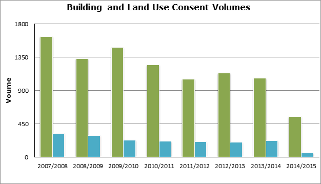
Figure 1 shows,
that over the reporting period, land use consents constitute 18.4% of all
building consents, or, roughly, for every 5 building consents, 1 required
resource consent. Whilst there will be occasions where an activity requires a
land use consent but not a building consent (and vice versa), this
limited assessment shows that the predominant pattern is that a range of
building works have been undertaken without the need for further regulatory
intervention.
The extent to
which a District Plan intervenes on land use activities can have
implications for the development process. The current level of intervention by
the Plan reflects an approach that aims to ‘avoid unnecessary regulatory intervention’[3]. Notwithstanding
this, it is important to assess the occasions where intervention was required
in order to understand whether an adequate level of environmental protection is
also afforded by the Plan.
2.2 Subdivision
and Development Activity
Subdivision is
part of the land fragmentation process. It is a key indicator of demand for
development and a test for the effectiveness of the plan. Figure 2 below
outlines the total number of new lots created by subdivision processes
across the District and by Ward from 2007-2014. The number of new lots created
has been decreasing since 2007/08. The total lots created over the period
reported is 3,435.
Figure 2 –
New Lots Created 2007-2014
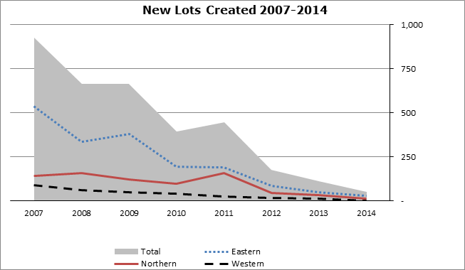
The economic
climate of the Far North is an important backdrop to consider against this data
and is likely to be consistent with other territorial authorities in provincial
regions around New Zealand. Table 1 below shows the number of lots
created against the number of new buildings/dwellings.
Table 1
– Number of lots created against the number of new buildings/dwellings
|
Year
|
Number of Lots
|
New Buildings/Dwellings
|
Surplus/Deficit Lots
|
Surplus/Deficit %
|
|
2007/08
|
925
|
539
|
386
|
26.3%
|
|
2008/09
|
665
|
370
|
295
|
28.5%
|
|
2009/10
|
664
|
356
|
308
|
30%
|
|
2010/11
|
395
|
243
|
152
|
23.8%
|
|
2011/12
|
446
|
222
|
224
|
33.5%
|
|
2012/13
|
177
|
225
|
-48
|
-11.9%
|
|
2013/14
|
112
|
290
|
-178
|
-44.2%
|
|
2014/15
|
51
|
181
|
-130
|
-56%
|
The number of new
buildings in the 2014/2015 year to date has been higher than the number of lots
created by over 50%. This data suggest an uptake of lots created in the
previous surplus period between 2007-2012 or a number of new builds on existing
lots. This trend has been occurring for the last three years. Notwithstanding
this relative assessment, with reference to the data collected in the last
eight years the District has a surplus of 1,009 lots.
From a spatial
planning perspective, the uptake of existing lots may represent a positive
trend towards consolidation of growth in existing areas. It is considered that
this outcome is a result of a weakening economy rather than pro-active
planning. The data is important to monitor over time and will provide, amongst
other considerations, a measure of supply and demand pressures across the
District.
2.3 Resource Consent Data
Figure 3 below shows
resource consents granted from 2007-2015 and includes subdivision consents
(RMASUB) land use consents (RMALUC) and combined subdivision and land use
consents (RMACOM). The table also separates the data into Urban, Coastal and
Rural Environments. The total consent figure for the sample period was 2,852.
The Rural Environment consisting of the Rural Production and Rural Living Zones
included 1,289 consents, with 470 land use and 543 subdivision consents issued.
Overall, this accounted for 45% of all consents in the sample.
Figure 3 –
Resource Consents 2007-2015
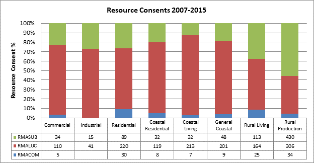
The Coastal
Environment made up of the Coastal Residential, Coastal Living, and General
Coastal Zones included 820 consents, with 533 land use and 112 subdivision
applications issued. This accounted for 26% of all consents.
The Urban
Environment made up of the Residential, Commercial and Industrial Zones
included 743 consents, with 351 land use and 138 subdivision applications
issued. This accounted for 29% of all consents.
Figure 4 below
highlights where consents have been issued throughout the district. The
majority of consents were issued in the Kerikeri and Northern communities
reflecting known trends of growth in the districts eastern and northern areas. Figure
5 provides more detail by highlighting the top five suburbs where activity
is occurring.
Figure 4
– Resource Consents by Community 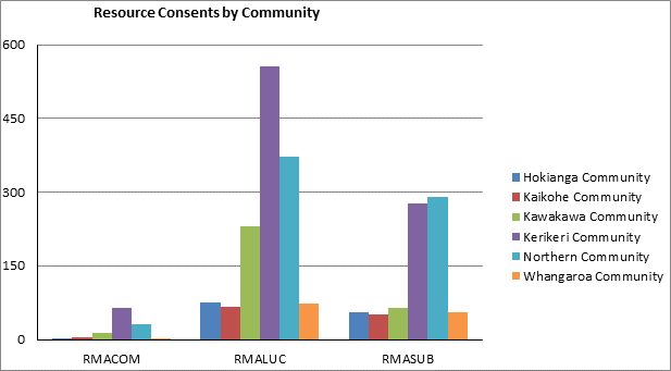
Figure 5 below
identifies where the majority of consented activity is occurring. Kerikeri had
767 consents issued, being 33% of all consents received over the sample period.
The other four locations made up 21%, therefore the top five locations alone
accounted for almost half of all development in the district.
Figure 5 –
Resource Consents by Locality (Top Five)
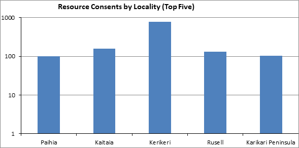
Since 2009, the
proportion of land use consent to subdivision consent applications has
increased. Subdivision consents generally reflect growth and development in an
area and may reflect the prevailing economic climate. The period between 2007
and 2010 represented 56% of all consents being issued, with both land use and
subdivision consents reaching a peak in 2008. Notwithstanding, there was a
large dip in consents issued in 2009. It is considered that this data is
reflective of the economic climate of the time.
Figure 6 –
Resource Consent 2007-2015
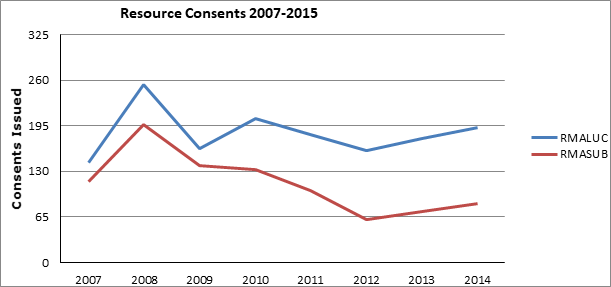
As shown in Figure
6 above, in 2012, 221 consents were issued which was the lowest in the
period. Since 2012, there has been a consistent upward trend in consents
issued.
Data relating to
average lot sizes has not been updated since 2011.The average lot size, by Zone
from the 2011 data are provided found in Table 2 below.
Table 2 –
Average Lot Size by Zone 2007-2011
|
Zone
|
Average Lot Size
|
Minimum Lot Size (Controlled)
|
Minimum Lot Size (Discretionary)
|
|
Rural Production
|
17.6ha
|
20ha
|
4ha
|
|
Rural Living
|
1.24ha
|
4,000m2
|
3,000m2
|
|
General Coastal
|
18.76ha
|
n/a
|
Management Plan required (20ha as Restricted
Discretionary Activity)
|
|
Coastal Living
|
1.68ha
|
4ha (provision for stormwater & wastewater disposal
required).
|
5,000m2 (provision for stormwater &
wastewater disposal required).
|
|
Coastal Residential
|
2,155m2
|
3,000m2 (unsewered); 800m2
(sewered)
|
2,000m2 (unsewered); 600m2
(sewered)
|
|
Commercial
|
1,495m2
|
3,000m2 (unsewered); 250m2
(sewered)
|
2,000m2 (unsewered); No Limit (sewered)
|
|
Industrial
|
1.2ha
|
3,000m2 (unsewered); 500m2
(sewered)
|
2,000m2 (unsewered); No Limit (sewered)
|
|
Residential
|
1,568m2
|
3,000m2 (unsewered); 600m2
(sewered)
|
2,000m2 (unsewered); 300m2
(sewered)
|
Rural Production
and Coastal Living Zones average lots sizes were below the Controlled Activity
threshold, but larger than the Discretionary limit. All other zones’
average lot size were above the Controlled threshold.
2.4 Resource
Consent Processing
Processing
efficiency has been the focus of recent changes to the RMA alongside changes to
the standard and quality of resource consent applications lodged with consent
authorities. It is anticipated that, with the lifting of the standard of
consent application, resource consent processing efficiency will improve.
Table 3 below
highlights historical trends with respect to the use of section 37 and 92 of
the RMA and consent applications processed on time[4]. While
this data relates to all resource consents as opposed to specific Urban
Environment consents, they still provide valuable information for analysis.
The table shows
that the amount of consents processed on time, over the period has increased.
This is unlikely to be due to more effective provisions, rather as a result of
efficiency gains in processing. The use of section 92 has been relatively
consistent at around 40-48% of consents. The use of section 37 has increased,
however data from previous periods is not in an accessible format for greater
analysis. Future reporting will help to provide further analysis.
Table 3 –
Use of Section 37 and 92 2005-2013
|
|
Processed on time
|
Use of s 92
|
Use of s 37
|
|
2005/06
|
51%
|
43.44%
|
n/a
|
|
2007/08
|
37%
|
48.44%
|
n/a
|
|
2010/11
|
95%
|
41.43%
|
3%
|
|
2012/13
|
94%
|
46.76%
|
20%
|
2.5 Resource
Consent Costs
Figure 7 below
highlights the average costs for combined, subdivision and land use consents.
Land use consents on average cost $2,000; subdivision consents cost $2,225 and
combined consents costs $3,650. Costs for each Environment are highlighted in
this report in their respective section. This more in depth analysis provides
clarity as to what areas of the district have higher compliance costs relative
to others.
Figure 7 –
Overall Average Resource Consent Costs
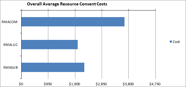
3.1
Tangata Whenua Policies: Methods and Expected Outcomes
The monitoring
provisions of the District Plan and the monitoring processes of the Monitoring
Strategy use evaluation of the Expected Outcomes to determine efficiency and
effectiveness for s35(2A) reporting. It is therefore essential that the
Expected Outcomes are able to be monitored, and that targets or benchmarks are
measurable. A full analysis of the tangata whenua provisions of the District
Plan is in the process of being completed. Preliminary results of that
analysis show that there are deficiencies in these provisions which have
consequences for the implementation of s35 monitoring. These deficiencies
include:
▪ Many of the tangata whenua provisions
are expressed in high level terms, and lack operational effectiveness.
Their results are also difficult to measure as the provisions are too broad and
general for causality to be determined.
▪ Frequently in the provisions s6(e) of
the RMA is presented verbatim, or with minor changes or additions, adding no
value to the Plan above that available from the statute itself.
▪ In the tangata whenua chapter there
are breaks in the cascade from Issues to Objectives to Policies to Methods,
which means that in practice implementation of some provisions is not required.
▪ The tangata whenua provisions are
almost all in the tangata whenua section, and tangata whenua provisions are
generally absent from the rest of the Plan.
▪ There are few cross references in the
Plan.
▪ Many terms require explanation if they
are able to be used by decision makers. For instance, Policy 12.2.4.1 has
a requirement for “maintaining tikanga”. If there were to be
Expected Outcomes for this Policy, clarification of meaning would be essential.
3.1.1
Indicators from the Monitoring Strategy
The Monitoring Strategy
2008 contains tangata whenua indicators, but they are of limited use for s35
evaluation of the tangata whenua provisions. The indicators and their
limitations are identified below:
Indicator: “Develop and
review an organisational definition of “The
Principles of the Treaty of Waitangi” and their implications”
This indicator if implemented should determine which
rights are being considered. How they are given effect in the Plan could
then follow.
Indicator: Findings of a Treaty audit.
A Treaty analysis
designed for and focused on the Plan provisions could result in effective
monitoring. However the detail of the design is critical. Treaty
audits are generally undertaken for organisations and their overall
performance. For the Plan a different methodology would be required.
Indicator: The level of expressed satisfaction by
tangata whenua at hui-a-iwi in the context and implementation of the Plan in
relation to sections 6, 7 & 8 of the Act.
This indicator has
such a broad scope that it would be difficult and / or extremely expensive to
implement.
Indicator: The % of recommendations implemented into
council policy and processes from Iwi/Hapu Environmental Management Plans,
Cultural Impact Assessments and other reports provided to council
Iwi planning
documents and Cultural Impact
Assessments do not have effective provisions for their support and use in the
Plan. This indicator should be easily implemented, and its results then
should inform the need for amendments.
Indicator: The rate of loss or modification, in
numbers and by type, of legally protected Sites of Cultural Significance to Māori,
Historic Sites, Heritage Precincts and archaeological sites.
In principle this
indicator should be able to be implemented for most the resources, as data on
impacts on scheduled sites should be available. However data on some
non-scheduled and previously unknown archaeological sites which are
accidentally discovered during development is more difficult to collect.
Indicator: Any change in the number, size and
role of papakāinga in the District.
Data has been
collected on papakāinga development (refer to Part C) But while the data
exists, it is only able to be used for monitoring if it is evaluated against
benchmarks or targets.
3.1.2 Key Issues
· Tangata whenua
provisions are too confined in the policy framework
· Monitoring provisions
lack specificity
· Monitoring techniques
lack follow through
Given the
strategic initiatives that Council have now identified regarding the enabling
of Māori land for development, further consideration is needed of a means
to develop effective policy with measurable performance indicators.
3.2 Urban Growth Management
The
focus of the Urban Environment and the Residential, Commercial and Industrial
Zones is generally related to three themes:
• The reduction
and/or mitigation of reverse sensitivity effects and occurrences;
• the protection
of existing character and amenity; and
• the timely
provision of infrastructure and services.
This review found
that, overall, the plan had a moderate influence in achieving the intended
outcomes. The Residential Zone had a strong ability to influence outcomes
whereas the Commercial and Industrial Zone had a moderate-poor influence.
3.2.1
Effectiveness
The
policies and methods of the Urban Environment are largely being implemented,
although more work could be done with respect to giving effect to the Other
Methods contained in this chapter, particularly advocacy and education relating
to Low Impact Design principles and their benefits. Policies and methods for
the Residential Zone are largely being implemented, as typical development
tends to trigger a number of rules. Typical development in the Commercial and
Industrial Zones tend to trigger fewer rules. The extent of outcomes
being achieved is linked to the level of implementation of the methods.
Analysis of resource consent conditions found that the Residential Zone
provisions and conditions were contributing to the achievement of the intended
outcomes. Conversely, it was found that while provisions and conditions in the
Commercial and Industrial Zone were contributing to outcomes when implemented,
the lack of differentiation across the two zones is leading to adverse
outcomes. This includes the under utilisation of industrial infrastructure
through the uptake by retail and commercial land uses in the industrial zones.
The examples of Waipapa and Kaitaia North were considered as case studies to
highlight these outcomes.
3.2.2
Efficiency
A sample of commonly
breached provisions were assessed. This found that all could be improved in one
way or another to increase their performance and the benefits that derive from
their implementation. Overall, the analysis has shown that there is room for
improvement with respect to the efficiency and effectiveness of the Urban
Environment and future review processes with respect to the District Plan
should take these into account.
3.2.3
Key Issues:
· Need for
simplification of policy frameworkNeed for improved connectivity in policy
framework including spatial responses to supply and demand pressures
· Greater
differentiation required between Commercial and Industrial Zone provisions
3.3 Rural Sustainability
The
Plan making process for the operative Far North District Plan carefully
considered the balancing of regulatory intervention in the rural environments,
being mindful of the scale and nature of the resources within rural areas and
the role played by voluntary mechanisms in providing for sustainable management.
The outcome was a plan that took a very deliberate stance with respect to
enabling activities within the Rural Production Zone.
Concerns were
raised during the development of Plan that the enabling an effects based
approach will allow a wide range of activities to establish in a zone, thereby
undermining its intent. The section 32 analysis prepared in 2000 to support the
proposed plan, provided the following in relation to the combination of
voluntary and regulatory methods to provide for rural sustainability;
“constant monitoring will provide information as to
the effectiveness of the proposed method. The Act allows Council to change its
district plan should evidence emerge that the proposed method is not achieving
the purpose of the Act.”
Since that time,
Council has become aware of a variety of issues that undermine the sustainable
management of rural areas. In particular, the ad hoc development of commercial
and industrial activities is leading to an increased risk of reverse
sensitivity and land use incompatibility; and potential for cumulative effects
including adverse effects on amenity values associated with the rural
environment.
The permissiveness of
the Rural Production Zone also allows for less certainty in the programming of
the location and scale of urban infrastructure. The existing policy framework,
which allows a wide variety of activities to take place in the Rural Production
Zone, enables urban style commercial and industrial development to establish
with its associated cumulative adverse effects.
3.3.1
Efficiency
The inefficiencies
of the policy framework lead to the promulgation of Proposed Plan Change 15
Rural Provisions in 2013. This outcomes of this proposed plan change is still
to be determined, however, the initial intent was to sequence the review of
rural provisions with a review of Rural Zones and Subdivision regime. This
process will now be fulfilled by the comprehensive District Plan Review
process., which will ensure that a balance is achieved both within the
Rural Zone taking into account the zone interface with the urban environment
and the supply of commercial and industrially zoned land.
3.3.2
Effectiveness
The preliminary
scoping report entitled “The Impact and Effect of Industrial and/or
Commercial Activities on Rural Character and Amenity in the Far North
District”, identified cause for concern that the Plan may not contain
adequate or appropriate controls to ensure the protection and enhancement of
rural amenity.
Subsequent
preliminary consultation on Rural Amenity Values undertaken as part of the
scoping document was limited in number, but included some useful feedback from
Federated Farmers, NZ Transport Agency and local planning practitioners. Views
were mixed in regard to how much, and what, should be amended in the District
Plan. On balance there was an acknowledgement that the maintenance and
enhancement of amenity values was important to the community and to
individual land owners, but there was no universal consensus as to how this
would be best achieved.
3.3.3 Key Issues
· Need for more
effective monitoring of permitted activities
· Land fragmentation
trends to be better understood in the context of productive uses
· Need for improved
management of urban and rural interface
3.4 Heritage
Under ‘Section 6
Matters of national Importance’ of the RMA, all persons exercising
functions and powers under the Act, shall recognise and provide for 6(e) “the
relationship of Māori and their culture and traditions with their
ancestral lands, water, sites, waahi tapu, and other taonga” and “6(f)
the protection of historic heritage from inappropriate subdivision, use, and
development”.
The Heritage New Zealand
Pouhere Taonga Act 2014 provides that Heritage NZ Pouhere Taonga maintains the
New Zealand Heritage List/Rārangi Kōrero. Inclusion on the list does
not provide automatic protection but it does record the importance of historic
places. The Heritage New Zealand Pouhere Taonga Act 2014 gives legal protection
to archaeological sites.
In 2012 some interim data
gathering was carried out in regard to heritage and report card produced titled
‘Cultural and Historic Heritage’. An evaluation of the data, along
with other appraisal processes identified that the plan is performing it’s
statutory role of protection of historic heritage, however, the dynamic nature
of our understanding of these resources and the means by which aware,
understanding and protection may be achieved, requires updating.
3.4.1
Efficiency
There are 245 heritage buildings,
sites and objects listed in Appendix 1E - Schedule of Historic Sites, Buildings
and Objects of the Far North District Plan.
In 2010 Plan Change 4, “Schedule
of Notable Trees, Historic Sites Buildings and Other Objects” sought to
make amendments to the Far North District Plan schedules. A number of historic
buildings were included in Appendix 1E and modifications will be made to the
district plan resource maps to reflect these changes.
In 2012 Plan Change 11,
“Review of Heritage Schedule” sought to make further
amendments to Appendices 1E - Schedule
of Historic Sites, Buildings and Objects of the District Plan to update the
schedule in order to improve efficiency.
3.4.2
Effectiveness
The review of the
data indicates that despite these recent reviews, there are less heritage
buildings, sites and objects listed in Appendix 1E of the District Plan than
are identified in the New Zealand Heritage List/Rārangi Kōrero
(formerly the Register). This suggests that more heritage items may need to be
afforded the additional protection of the district plan as inclusion in the New
Zealand Heritage List/Rārangi Kōrero (formerly the Register) does not
provide automatic protection.
3.4.3 Key Issues
· Currency of
Heritage inventories
· Further scope for
promotion of other methods to increase awareness and understanding of resources
3.5 Coastal Protection
The
coastline in the Far North is long and varied and contains eight major harbour
systems. There are a number of values attributed to the coastal environment
that contribute to its natural character, which include landscape, ecology,
tangata whenua and historic values. Of the Far North’s
651,709ha, 0.48% of land is zoned ‘Coastal Living’, 0.12%
is zoned ‘Coastal Residential’ and 9.44% is zoned
General Coastal.
It is a complex
environment, accommodating dynamic natural processes, unique natural and physical
attributes and high cultural values. The environment is subject to varying
degrees of growth pressure. Responsiveness of the plan’s policy framework
to the multifaceted issues is similarly challenging. This is primarily
contained in Chapter 10 of the operative District Plan.
3.5.1
Efficiency
In a general
sense, the issues for the Coastal Environment are not concise, and in certain
cases lack clarity.
The objectives in
the coastal zones have generally been drafted like policies in that they are
explaining the ‘how’. In many instances they talk about avoiding,
remedying and mitigating where they should be denoting the
‘outcome’.
The provisions
that relate to the suite of coastal zones often share a number of the same
issues, as such there are a number of instances where duplication occurs across
the provisions. The issues identified within the suite of Coastal zones
represent a common theme, only there are slight variations on each occasion. In
essence all are saying:
▪ There is pressure
for development to be located near the coast.
▪ Not all
development is sympathetic to the character of the coastal environment
▪ We need to
sustainably manage the development of the coastal environment
The issues drafted
in the coastal environment are generally more overarching than those identified
in the following coastal zones.
In some instances
there is no clear cascade or link through the provisions starting from the
Issues, and then moving through the Objectives and Policies. On a number of
occasions the link through to the objectives and polices is weak or
non-existent. In many of the Coastal zones provisions are double and triple
used to enable the cascade from Issues through to Policies.
3.5.2
Effectiveness
Since 2007, the
Coastal Environment has consistently had more land use consent applications issued
compared with subdivision consent applications. In general subdivision signals
new development and growth and it is closely aligned with the prevailing
economic climate. As the economy slows there is less impetus for growth.
However, despite subdivision consents (red) having slowed substantially since
2007, there has been a steady flow of land use consents (blue) which suggests
that activities such as infill development, additions/alterations, and changes
of use have still occurred over that period as shown in Figure 8
Figure 8 –
Coastal Resource Consent 2007-2015
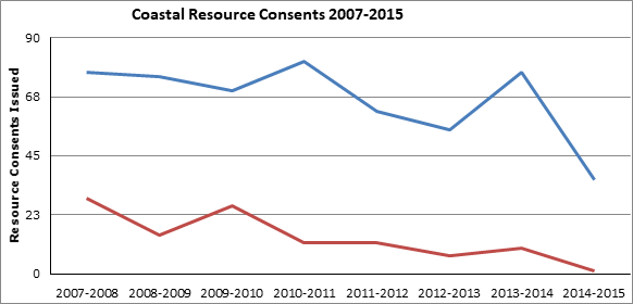
Of the sample of
232 breaches, 99 related to the Coastal Living Zone. Breaches of the Visual
Amenity were by far the most common at 32% followed by Impermeable Surfaces
(13%), Setback from Boundaries (11%), and Stormwater Management (7%). The
nature of the breaches suggests that the degree of development was greater than
that envisaged by the provisions in the plan. Most of the Visual Amenity
breaches related to buildings where, as a permitted activity, control over a
new building as a permitted activity is limited to 50m2 and any
alteration/addition is limited to a 30% in addition to that which currently
exists.
Figure 9 –
Activity Status of Consents in the Coastal Environment 2007-2015
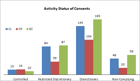
Of the resource
consents that required consent over 50% of them were Discretionary activities.
In most instances this activity status would have been triggered because
applications failed to comply with one or more of the standards for permitted,
controlled or restricted discretionary activities as seen in Figure 9.
3.5.3 Key Issues
· Simplification of
policy framework
§ Need for improved connectivity in
policy framework
3.6 Outstanding Landscapes
Outstanding
Natural Landscapes have been identified in the District Plan and result from a
requirement under section 6(b)[5] of the Resource
Management Act 1991 (RMA) to protect such landscapes from inappropriate
subdivision, use and development.
Of the Far North’s 651,709ha,
143,622ha or 22% of land is identified as an Outstanding Landscape. This
identification was completed as part of an assessment undertaken by consultants
LA4 in the mid 1990’s. Of the land identified as Outstanding Landscape 46.9%
is within public ownership and 53.1% is privately owned.
Outstanding
Natural Landscapes provide significant public benefit for the district,
including the economic benefits of tourism, recreational use and aesthetic or
cultural values. Coupled with this benefit however is a cost to the landowner
in terms of development rights and use of the land. Māori also have a
stake in this regard as they have large tracts of land identified within
Outstanding Natural Landscapes.
3.6.1
Efficiency & Effectiveness
Giving effect to
the higher order statutory documents
The District Plan
under section 75(3)[6] of the RMA is
required to give effect to the New Zealand Coastal Policy Statement (NZCPS) and
the RPS.
The Supreme Court
issued what has become commonly known as the ‘King Salmon’ decision[7] on 17
April 2014. The decision contains important guidance on how policies within the
NZCPS are to be interpreted, particularly where policies are prescriptive in
their intent. Policy 15(a) of the NZCPS requires that council planning instruments
shall ‘avoid’ adverse effects on Outstanding
Natural Landscapes, which are currently mapped by FNDC and the Northland
Regional Council.
The words in the
NZCPS are clear and directive. Where the word ‘avoid’ is used
it means ‘not allow’ or ‘prevent the occurrence of’[8]. King
Salmon states that an ‘overall balancing approach’ should
not be used when implementing the directive or prescriptive policies of the
NZCPS. In the case of Policy 15 an ‘environmental bottom line’ is
created and the adverse effects cannot be balanced against positive effects
through revisiting Part 2 of the RMA. The following policies in the District
Plan are at conflict with the interpretation of the NZCPS through King salmon
decision:
Policy 1 - “That both positive and adverse effects
of development on outstanding natural features and landscapes be taken into
account when assessing applications for resource consent.
Policy 2 – That activities avoid, remedy or mitigate
significant adverse effects on both the natural and the cultural values and
elements which make up the distinctive character of outstanding natural
features and landscapes.
Policy 3 - That the cumulative effect of changes to the
character of Outstanding Landscapes be taken into account in assessing
applications for resource consent.
Policy 5 - That the adverse visual effect of built
development on outstanding landscapes and ridgelines be avoided, remedied or
mitigated.”
3.6.2 Consistency
of language
“Outstanding
Natural Landscapes” is the term use in section 6(b) of the RMA, in Policy
15(a) of the NZCPS and in the RPS. The District Plan currently uses the term
“Outstanding Landscapes”, which is inconsistent with these higher
order documents. This has the potential to add confusion as the term
“Outstanding Landscape” is not defined or used anywhere else in any
relevant statutory documents. Consistency of language is important as it
enables the plan user more certainty, in this case when addressing matters of
national importance. The intent of the District Plan provisions is to protect
Outstanding Natural Landscapes, as such the term should remain the same and not
be shortened to a term not consistently used elsewhere.
3.6.3 The drafting
of Issues
Issue 1 identifies
Outstanding Natural Landscapes and their capacity to accommodate change without
appreciable ‘visual impact’. Outstanding Natural Landscapes are
identified using a set of values or attributes called the WESI or Pigeon Bay
criteria. There are a number of different values or attributes that may contribute
to a site being identified as ‘outstanding’, it is not limited to
just ‘visual impact’. Instead of just identifying ‘visual
impact’ it would be more appropriate to identify the
‘characteristics and qualities’ or the ‘attributes’
that contribute to the values that make up an Outstanding Natural Landscape, as
opposed to just singling out one. This issue would be better drafted to read:
The values attributed to Outstanding Natural Landscapes
and Outstanding Landscape Features have a relatively low capacity to
accommodate change.
Issue 7 as it is
framed has no place in this chapter because Māori cultural landscapes are
primarily different to Outstanding Natural Landscapes. Tangata whenua values
are an attribute or value to consider when identifying an Outstanding Natural
Landscape, however Māori cultural landscapes as such are not a section 6b
RMA matter (unless they contribute to the overall values of an Outstanding
Natural Landscape).
3.6.4 The drafting
of Objectives
The objectives in
the natural and physical resources chapter have generally been drafted like
policies in that they are explaining the ‘how’. In some instances
they identify avoiding adverse effects where they should be addressing the
‘outcome’. Below is an example of a current objective in the
District Plan relating to Outstanding Landscapes (or Outstanding Natural
Landscapes) and a suggested change to align with best practice. Note that the
protection of Outstanding Landscapes from inappropriate subdivision, use and
development is addressed already in Objective 1 and is repeated in the first
part of Objective 4.
Objective 4 To
avoid adverse effects and to encourage positive effects resulting from land
use, subdivision or development in outstanding landscapes and natural features
and Māori cultural values associated with landscapes.
Suggested change: Subdivision,
use and development is managed to encourage positive effects in Outstanding
Natural Landscapes, natural features and Māori cultural values associated
with landscapes.
3.6.5 Natural
Character of the Coastal Environment
The preservation
of natural character in the coastal environment and its protection from
inappropriate subdivision, use and development is a requirement in section 6(a)
of the RMA and Policy 13(1) of the NZCPS.
No policy
framework currently exists within the District Plan for the preservation of
natural character of the coastal environment and its protection from
inappropriate subdivision, use and development. The natural character areas of
the coastal environment have not previously been mapped by FNDC. The mapping of
high and outstanding natural character has recently been done by Northland
Regional Council. The criteria for establishing these areas are identified in
Policy 13(2) of the NZCPS. Inclusion of provisions that relate to the natural
character of the coastal environment could potentially either sit within this
chapter or within the coastal chapter.
3.6.6 Key Issues
· Consistency of
language with higher order statutory documents
· Drafting of the
policy framework is overly complex
3.7 Indigenous Flora and Fauna
The Far North District has a land area
of around 651,709 hectares.
Approximately 267,000 hectares of that area (around 40%) comprises of
indigenous habitat[9].
Due in part to the relatively large area of indigenous habitat remaining, but
also due to the district’s unique geology, the Far North retains a
diverse suite of ingenious ecosystems and is host to a large variety of native
plants and animals, many of which are found only in the Northland area. In fact
the Northland Region is commonly referred as a biodiversity hotspot owing to
the diversity of unique ecosystems and associated flora and fauna. The
Conservation Management Strategy for Northland (2014-2015)[10] identifies that a significant
number indigenous plants and animal in the Northland region are classed
“Threatened” or “At Risk” according to the Department
of Conservation’s New Zealand Threat Classification System. The effective
management of indigenous ecosystems is a particular challenge in the Far North
because a significant proportion of existing habitat is located on private
land. For example, according to the latest Statistics New Zealand Agricultural
Census, farmers identified that approximately 50,000 hectares of the
District’s 350,000 hectares of farmland comprises mature native bush or
regenerating native scrub or bush.[11]
3.7.1
Efficiency
The environmental outcomes set down in
Chapter 12.2 provide a clear expectation in respect of the maintenance and
enhancement of significant vegetation and rare or endemic plants and animals in
addition to improving the extent of formal protection of indigenous vegetation
on private land.
The provisions in Chapter 12.2 place heavy
reliance on non-regulatory mechanisms (i.e. “Other Methods”).
However many of these methods have not been implemented; or were implemented
and have since stopped, a key example being the Significant Natural Areas
Committee and associated funding. In this case the Committee was intending to
play a substantial role in developing voluntary means of maintaining, enhancing
and protecting indigenous habitat.
In addition to the limited implementation
of the “Other Methods” contained in Chapter 12.2, there is simply
insufficient information available to allow a detailed assessment of the
efficiency and effectiveness of Chapter 12.2. Of particular note is that there
is virtually no information available with regard to the extent of vegetation
clearance being carried out under the permitted activity rules contained in
Chapter 12.2. To put this issue into context, it is worth considering the
extent of the vegetation cleared under the previous permitted activity
framework. Specifically, between 2003 and 2007, following the full retraction
of the first proposed District Plan, the indigenous Flora and Fauna Chapter of
the Plan (then Chapter 11) contained a permitted activity rule that allowed for
the clearance of vegetation on rural production land provided 15 days notice
was given to FNDC. Whilst this rule was in effect FNDC maintained an effective
monitoring process. That process involved commissioning an ecological
assessment and long term monitoring of tracts of permitted vegetation
clearance. Over the four years that the rule was in effect, property owners
notified FNDC of indigenous vegetation clearance totaling 1,200 hectares.
Although the permitted activity provisions
at the time were not particularly useful at promoting the maintenance of
indigenous vegetation on private land, the notification and monitoring process
was at least an effective means of understanding the extent and type of
permitted indigenous vegetation clearance being carried out throughout the
district. In contrast, the permitted activity rules contained in the current
District Plan are substantially more restrictive but do not require any form on
notification. Consequently, since 2007, there has been no way of gaining a
detailed understanding of the extent or type of indigenous vegetation being
cleared that relies on the permitted activity rules in Chapter 12.2. This
represents a substantial knowledge gap, particularly taking into account the
limited area of vegetation clearance that has been authorised by resources
consents (see below).
In terms of consented activities, an
assessment of resource consents granted between 2007 to 2015 indicates that
very little vegetation clearance is being consented. Over that period, a total
of 24 resource consents were issued that allowed for indigenous vegetation
clearance. The vast majority of those authorisations were for ancillary
activities for property developments; that is, very few applications were for
indigenous vegetation clearance only. The total area of vegetation clearance
authorised by these resource consents is 8 hectares. Given that a total of 1200
hectares was cleared in the fours years between 2003 and 2007 as a permitted
activity (permitted clearance after that time is was not recorded), it is
reasonable to assume that the 8 hectares of consented clearance between 2007
and 2015 represents a minor proportion of actual indigenous vegetation removal
over that period, particularly taken into account the national trend of overall
biodiversity decline.
3.7.2
Effectiveness
Far North District Council does not hold
any detailed information that would enable a comprehensive assessment of the
effectiveness of the District Plan with regard to the maintenance and
enhancement of biodiversity. However, it is possible to piece together a broad
understanding based on current empirical work and the small amount of data FNDC
does hold.
Most notably, Landcare Research has
completed a large amount of work over the years assessing the temporal changes
in indigenous land cover at a national scale (for example Walker et al.
2005, Walker et al. 2006, Cieraad et al. 2015). The work carried out by
Cieraad et al. (2015) reports on the most recent synthesis of land cover
changes, providing a national scale assessment of remaining native biodiversity
in New Zealand drawing on the results of updated spatial datasets of New
Zealand land cover. The overall national trend over the last decade has been
one of biodiversity decline.
It should be emphasised that the work
carried out by Landcare provides a national scale picture, and so it cannot be
used to draw direct conclusions for the Far North. However, to understand the
matter further, Landcare Research was commissioned to complete an assessment of
land cover change between 2002 and 2012 using the same spatial datasets
utilised by Cieraad et al. (2015) covering the Far North District only.
The resulting map is provided in Figure 10 below.
The work undertaken by Landcare Research
suggests that the natation trend of overt habitat loss is carried though to the
Far North District, with around a 0.5 to 1% decrease of indigenous vegetation
cover along the east coast of the Te Hiku area, and decline of around 0.5-0.1%
throughout the rest of the district. Whilst the work produced by Landcare is
useful for providing an overall picture of land cover change throughout the
district, it should be noted that there are a number of data uncertainties with
the process used; that is, uncertainty about whether the changes were actual
change on the ground or database corrections or errors. Nevertheless the work
provides the best indication of indigenous land cover changes over the last
decade taking into account the limited information currently available.

In addition to the above work, the
Land Cover Database version 4[12] was used to complete an analysis of
changes in vegetation cover over the period of summer 2008/09 (around the time
the plan become operative) and summer 2012/13. The results of that analysis
indicate that indigenous vegetation cover throughout the district declined by
about 1200 hectares over the four year assessment period.
With regard to voluntary legal
protection of indigenous habitat, FNDC has implemented a policy (# R04/11) to
allow for the remission of rates on land subject to protection for outstanding
landscape, cultural, historic or ecological purposes. The policy was
implemented to give effect to Method 12.2.5.13 of the District Plan, which sets
out that FNDC will allow for to the remission or postponement of rates in areas
afforded permanent legal protection through a covenant or reserve status. Since
2002, the approximate area of covenants registered with FNDC that give
protection to indigenous
In addition to the above area,
long-term protection of indigenous habitat on private land is also secured via
Queen Elizabeth II National Trust (QEII) and Nga Rahui Whenua covenants. These
covenants are also subject to rates remission and postponement policy # R04/11.
Data provided by QEII indicate that a total of 187 covenants are presently
registered in the Far North District, covering a total area of 5171 hectares.
The total area protected by QEII covenants has nearly doubled since 2002, at
which point 2379 hectares was registered with the Trust.
With Regard to Nga Rahui Whenua sites,
the Ngā Whenua Rāhui Fund provides funds to help protect indigenous
ecosystems on Māori land. Information provided by the Department of
Conservation (which administers the fund), indicates that a total area of
around 6500 hectares of Māori land in the Far North District has gained
protection through the Nga Rahui Whenua process. It is assumed that this land
comprises exclusively of indigenous ecosystems.
Legal protection
In terms of levels of formal
protection, at a national scale, Cieraad et al. (2015) vegetation is
1839ha. QEII covenants, Ngā Whenua Rāhui protection and covenants
registered with FNDC for rates remission/postponement are the main forms of
voluntary legal protection on private land within the district. Together these
protection mechanisms equate to a total area of around 13,500 hectares, which
is about 10% of area of indigenous vegetation located on private land. It is
reasonable to assume the bulk of the FNDC covenants were registered in order to
receive the rates remission or postponement, and so it is possible to conclude
that 1839 hectares of indigenous vegetation on private land has been protected
largely through the implementation of Method 12.2.5.13 of the District Plan.
The influence of that method on the extent of QEII covenants is not so clear
because rates remissions is only one of many reasons why a property owner would
seek to protect indigenous vegetation on their land.
3.7.3 Key Issues
· Need for more
effective monitoring of permitted activities
· Need to give
effect to the non-regulatory methods contained in Chapter 12.2
· Need to better
understand the implications of the current rules framework, particularly in
respect of the fragmentation and isolation of indigenous habitat.
3.8 Renewable Energy and Energy
Efficiency
The first Council
initiated Plan Change relative to the Operative District Plan was dedicated to
the insertion of a policy framework promoting energy efficiency and enabling
provisions for renewable energy infrastructure.
The plan change
responded to a number of imperatives, including climate change, the costs of
energy provision, the dispersed settlement pattern in the Far North and the
opportunities for obtaining energy from renewable sources. The plan change also
gave effect to the National Policy Statement for Renewable Electricity
Generation 2011.
The District Plan
describes the purpose of the policy framework is to:
“enable individuals and communities to provide for their
own energy needs through the adoption of appropriate energy efficiency and
generation initiatives based on the abundant renewable energy resources of the
District. The objectives, policies and methods also recognise that utility
scale renewable energy developments have a role to play in securing a
sustainable energy future for the District.
The policy framework
includes a number of methods to promote micro and domestic scale renewable
energy infrastructure. Chapter 12.9 contains the policy framework and
provisions with other elements incorporated to the subdivision chapter.
3.8.1
Efficiency
Since the plan
change was made operative in 2009, there has been little testing of the policy
framework with domestic scale renewable energy infrastructure such as solar and
micro wind fitting within the permitted activity thresholds.
At the time of
writing of the section 35 report, a proposal to significantly increase the
capacity of the geothermal Top Energy Plant at Ngawha was received by Council
and under evaluation. The proposal represents a very positive step for the
utilisation of a renewable energy source and further moves towards self
sufficiency for the District’s energy requirements.
The policy
framework also extends to energy efficiency considerations in the design of
subdivisions, promoting lot orientation and scale to maximize solar
orientation. The regard given to this criteria is not yet apparent, due to the
relatively low numbers of submission applications received since the
introduction of this policy framework and associated provisions.
3.8.2
Effectiveness
Energy efficiency,
resilience of communities and improved self sufficiency are all issues that are
likely to assume greater importance over time. The current provisions of the
District Plan are considered to represent a very positive framework for the
deployment of renewable energy infrastructure and promoting the benefits of
energy efficiency at the time of subdivision, however, the consideration given
to energy efficiency outside of the subdivision provisions and when concerning
land use matters, may be deficient.
This is an
especially important issue when considering the development opportunities
represented by the District’s urban environment. For example, high yields
may be achieved within the Commercial zone, with no consideration required for
solar access to the living environment.
Other
“macro” scale matters require consideration of the efficiency of
energy use. For example, more compact centres offer greater and more efficient
interaction, increasing the potential viability of existing and new commercial
enterprises. Thus the density of our urban environment and the integration of
residential and employment areas require further regard in the policy
framework.
3.8.3 Key issues
· Relatively new but
policy important consideration, not yet fully testedFurther regard to energy
efficiency issues required for land use
· The potential
benefits of value of higher density with respect to energy efficiency must be
matched up with urban design and urban quality considerations
Part C
The
following section provides further detailed data regarding the performance of
the plan. Similar to Part B, there is general district wide data and topic
based data centered around the Significant Resource Management Issues. Due to
the nature of the issues, monitoring processes, extent and quality of
information available and policy evaluation techniques, there is some variation
between the individual sections regarding data presentation and analysis.
4.1 Tanagata Whenua
4.1.1 Monitoring
impracticalities
The following outlines some of the difficulties in
gathering information to ascertain the relative performance of the District
Plan in relation to tangata whenua policies and provisions. Reference is given
to the “Environmental Outcomes Expected” from Chapter 2
“Tangata Whenua” of the District Plan.
EOE 2.6.1 To the extent possible, the rights guaranteed to Māori
by Te Tiriti O Waitangi (Treaty of Waitangi) are given effect in the Plan.
The Plan is silent on the rights which are to be given effect in
the Plan. The Plan includes a set of Treaty Principles, and from these
some specific rights could be determined so that their provision could be
monitored. A more specific set of policies and then Expected Outcomes
could be developed while considering the monitoring methods.
EOE 2.6.2 Subdivision, use and development in the District
occurs in a way that recognises and provides for the relationship of Māori
and their culture and traditions with their ancestral lands, water, sites,
waahi tapu and other taonga.
This Expected Outcome, which includes s6(e) of the RMA, is very
broad in its expression. Samples of subdivision development could
be analysed against this broad outcome, but it would be preferable to develop a
more focussed set of outcomes which would be able to be monitored effectively.
EOE 2.6.3 Development on ancestral land occurs in a way that
achieves sustainable management of natural and physical resources, and protects
Sites of Cultural Significance to Māori and other taonga.
This Expected Outcome does
not anticipate any scale of development of Māori Land, only the extent to
which sustainable management has been achieved. This is again a very
broad outcome, and more focused outcomes are needed for monitoring.
There are tangata whenua
related Expected Outcomes in other chapters of the District Plan. These
are:
EOE
10.2.5 The relationship between Māori and their ancestral lands, water,
sites, wahi tapu and other taonga is recognised and provided for in the coastal
environment, including improved access for identified cultural and traditional
purposes. (Coastal Development)
This restatement of s6(e) is a very broad outcome, and again
objectives and measures would be extremely difficult to develop. Access
for identified cultural and traditional purposes could more readily be
identified and measured.
EOE
12.1.2.4 The relationship of Māori cultural values associated with
landscapes are recognised and provided for (Landscape and Natural Features)
District wide
identification of cultural values or cultural landscapes has not been
implemented and no recognised methodology for identification of cultural
landscapes has been developed. Until this is achieved monitoring of this
outcome is not possible.
EOE
12.5.2.7 Recognition and retention of the Māori values relating to sites
of cultural significance. (Heritage Precincts)
This more focussed outcome can be measured. The
indicators in the Far North Monitoring strategy can be used. Within
Heritage Precincts the culturally significant resources will be more easily be
identified. Heritage Precincts are in a defined area, and in that area
there has been a focus on heritage resources.
EOE 12.9.2.8 To achieve the objectives, policies and outcomes of
Chapter 2 - Tangata Whenua the following outcomes are expected:
§ Energy
efficiency and greater use of renewable energy are encouraged during the
establishment of papakainga on Māori Freehold Land.
§ Initiatives to
support renewable energy provision and greater levels of energy efficiency
within Māori communities are facilitated through partnership between
Iwi and other agencies.
§ Engagement and
involvement of local Māori occurs at the early stages of development of
renewable energy proposals.
These more focussed outcomes can be measured.
EOE 13.2.1 A subdivision pattern that is consistent with:
….
(e) the
relationship of Māori and their culture and traditions with their
ancestral lands, water, sites, waahi tapu and other taonga
This restatement of s6(e) is a very broad outcome, and again
objectives and measures would be extremely difficult to develop.
Because of the nature of
the District Plan Tangata whenua provisions monitoring effectiveness and
efficiency is not currently possible.
Best practice requires
development of indicators and monitoring processes should be an intrinsic part
of plan review and plan development. Clearly the tangata whenua provisions
of the District Plan need amendment before monitoring can be implemented.
Therefore the current review of the tangata whenua provisions of the plan
provides an ideal opportunity to develop new provisions enabling effective
monitoring processes.
For that process to be
effective:
· Policies should be reviewed and
amended where greater specificity and detail is required.
· Expected Outcomes must be written in a
form that facilitates indicator development and monitoring.
· Tangata whenua policies need to be
throughout the Plan, as well as in a specific tangata whenua section, and
appropriate and measurable Expected Outcomes are needed for them.
· Processes other than formal monitoring
should be used for data collection.
Table 4 - Integrated development
|
|
RC #
|
Applicant
|
Zone
|
Rule
|
Activity
Status
|
Date
Approved
|
Address
|
Description
|
|
1
|
2100067
|
HNZ Corporation Ltd
for the Motuti Marae Trustees
|
RP
|
8.6.5.4.2 INTEGRATED
DEVELOPMENT
|
D
|
22-Oct-2009
|
Motuti Rd, Panguru
|
INTEGRATED DEVELOPMENT
IN FOUR (4) STAGES:
Stage 1) Three (3)
additional dwellings plus one converted dwelling;
Stage 2) Additions
to, and renovation of, ablution block, and upgrade of water supply;
Stage 3) Upgrade
facilities at the harbour access; and
Stage 4) New
museum/cafe/craft-produce shop complex for enhancement of the Marae's tourism
venture.
Note: The consent
has a 10 year consent period.
|
|
2
|
2100364
|
Aubrey Tepania
|
GC
|
10.6.5.4.4
INTEGRATED DEVELOPMENT
|
D
|
15-Mar-2010
|
Foreshore Rd,
Ahipara
|
The construction of
a second residential dwelling and garage, by way of Integrated Development
rule on a parcel of Māori Freehold Land.
|
|
3
|
2110303
(lodged 21-Mar-2011)
|
Takou Ahu-Whenua
Trust
|
RP
|
8.6.5.4.2
INTEGRATED
DEVELOPMENT
|
D
|
Suspended since 15-Apr-2011
|
Te Ra Rd, Takou Bay
|
To undertake an
Integrated Development on the site over a ten year consent period. Proposed
marae , social services and minor upgrading to the existing campground. The
proposal is for a marae centred community development with a residential
component to include license to occupy areas for the 17 existing dwellings on
the site and the provision of 81 new housing sites plus infrastructure.
Note: this rc has
been suspended under s92 for further information since 2011
|
|
4
|
2120157
|
Rangi Taua Whanau
Trust
|
RP
|
8.6.5.2.2
PAPAKAINGA HOUSING
|
C
|
29-Nov-2011
|
Whakataha Rd,
Waimate North
|
To construct four
dwellings under the Papakainga rule of the District Plan.
|
|
5
|
2130203
|
He Korowai Trust
|
RP
|
8.6.5.4.2
INTEGRATED
DEVELOPMENT
|
D
|
26-Jul-2013
|
Kohuhu Street,
Kaitaia
|
To relocate six
dwellings onto a site that is zoned both Residential and Rural Production.
The proposal is an affordable housing project named "Project Whare
Ora". Three existing houses are located on the site which form part of
the multi stage affordable housing project. This application relates to stage
2 only, being the establishment of 6 additional dwellings.
Note: the Rural
Production part of this application was applied for under the Integrated
Development rule, the rule does not apply in the Residential zone. The He
Korowai Trust changed general land to Māori land in order to be able to
use this rule.
Note: This
application was limited notified and went to hearing and was approved by the
Hearing Commissioner
|
|
6
|
2140207
|
Reuben Porter
|
RP
|
8.6.5.2.2 PAPAKAINGA
HOUSING
|
C
|
12-Feb-2014
|
Ngakaroa Rd, Ahipara
|
To construct an
additional 3 rammed earth dwellings as part of a Papakainga Development in
the Rural Production Zone.
|
|
7
|
2150101
|
Te Aupouri
Māori
Trust Board
|
RP
|
8.6.5.4.2
INTEGRATED
DEVELOPMENT
|
D
|
24-Dec-2014
|
Potahi Road, Te Kao
|
To establish 12
additional residential units in two stages within an existing Papakainga
Development in the Rural Production Zone under rule 8.6.5.4.2 'Integrated
Development' of the District Plan.
|
Since 2009 there have been seven resource consent applications
under the Papakainga Housing and Integrated Development rules in the Far North
District Plan. Five applications have been made under the Integrated
Development rule and two under the Papakainga Housing rule. Six of the
applications have been approved, one is currently suspended under s92 of the
RMA 1991 and has been awaiting further information since 2011. Five of the six
approved applications were non-notified and one was limited notified, went to
hearing and was approved by the Hearings Commissioner, subject to conditions.
Six of the seven applications were in the Rural Production zone and one was in
the General Coastal zone.
4.2 Urban Growth
Of the Far North’s
651,709ha, just 0.28% of land is defined within the ‘Urban
Environment’; Residential (1,550.9ha or 0.24%), Commercial (257.4ha or
0.04%), and Industrial (494.8ha or 0.08%). These three zones make up the
‘Urban Environment’ of the Far North District. The ‘Rural
Environment’ made up of the Rural Production (456,052.8ha or 69.98%),
Rural Living (2,625.2ha or 0.40%), and Minerals zone (1,017.6ha or 0.16%) and
accounts for 70.54% of the District’s land mass.
Key
observations relating to the internal consistency of the Urban Environment are
considered in the table below. The internal consistency table assesses the
influence the Plan has in providing for the outcomes intended. In summary, the
table below highlights that the Plan has a moderate influence in being able to
achieve its intended outcomes. The table finishes with a list of generic
recommendations that can be used to enhance internal consistency.
Table 5
- Internal Consistency
|
Urban Environment: Environmental Outcomes Expected
|
Relevant Theme
|
Internal Consistency
|
Summary of Key Observations
|
|
7.2.1 Urban areas
developed in a manner that promotes sustainable management of natural and
physical resources, while preserving the distinctive character and amenity of
each area.
|
Character
& Amenity
Provision
of Infrastructure/Services
|
Moderate
|
Overall, it is considered that the objectives and policies are
quite strong. However, the first part of the outcome is laden with RMA
terminology and is likely to be difficult to monitor.
Location specific rules relate to specific areas of Kerikeri and
Coopers Beach. All other rules are generic in nature, therefore the
‘distinctive character and amenity of each area’ mentioned may be
generalised over time. As a result, the preservation directive may be
difficult to implement.
|
|
7.2.2 Urban areas
where a wide range of activities are provided for in a manner which ensures
that adverse effects on the environment are avoided, remedied or mitigated.
|
Reverse Sensitivity
|
Moderate
|
It can be
argued that this outcome expected is not entirely consistent with an outcome
that seeks to preserve the distinctive character and amenity of areas.
In order
to reconcile the two, a level of differentiation across zone rules is
required. Industrial and Commercial zone rules are very similar and therefore
provide a potential barrier to this and associated outcomes being achieved.
|
|
7.2.3 Urban areas
containing a variety of residential and non-residential environments,
providing for a level of amenity which is appropriate to the particular
environment.
|
Reverse
Sensitivity
Character
& Amenity
|
Moderate
|
Objectives
and policies related to the themes are strong. Principal methods used include
zoning and associated rules. Difficulties arise when activities co-exist, for
example residential activities in commercial zones. The current framework is
responsive to one theme; reverse sensitivity; over character and amenity,
particularly in the Commercial and Industrial zones.
|
|
Residential Zone:
Environmental Outcomes Expected
|
Relevant Theme
|
Internal Consistency
|
Summary of Key Observations
|
|
7.6.2.1 Residential
areas containing a range of activities that are compatible, in terms of their
effects, with the predominant residential use and character of those areas.
|
Reverse
Sensitivity
Character
& Amenity
|
Strong
|
The
overall policy framework and suite of rules make a strong attempt at
influencing the outcome. While linkages are not explicit they are relatively
clear.
|
|
Residential Zone:
Environmental Outcomes Expected
|
Relevant Theme
|
Internal Consistency
|
Summary of Key Observations
|
|
7.7.2.1 Commercial
areas containing a wide range of activities, contributing to the everyday
needs and well being of the communities they serve.
|
Reverse
Sensitivity
|
Moderate
|
Similar
to above, the overall policy framework and suite of rules make a strong
attempt at influencing the outcome; however there can be unintended
consequences in promoting a wide range of activities. Contribution to well
being is degraded by a lack of differentiation across the Commercial and
Industrial zone methods.
|
|
7.7.2.2 Commercial
areas that are subject to environmental controls to protect their amenity and
that of adjoining areas, and which avoid, remedy or mitigate adverse effects
on the natural and physical resources of the District.
|
Reverse
Sensitivity
Character
& Amenity
Provision
of
Infrastructure/Services
|
Poor
|
While
amenity controls are present within the Commercial Zone,
‘amenity’ has not been defined or explained in detail. Therefore,
it is hard to test whether the policies, objectives and rules are fulfilling
their purpose. A focus on the amenity of commercial areas only also fails to
recognise the potential for mixed use development. This type of development
can positively contribute to the District’s natural and physical
resources and to favour commercial amenity creates tensions with other
potential uses.
|
|
Residential Zone:
Environmental Outcomes Expected
|
Relevant Theme
|
Internal Consistency
|
Summary of Key Observations
|
|
7.8.2.1 Industrial
areas contributing a wide range of activities that are mutually compatible in
terms of their environmental effects, and which contribute to the needs and
well being of the people of the District.
|
Reverse
Sensitivity
Character
& Amenity
Provision
of Infrastructure/Services
|
Moderate
|
See the
key observations noted for outcome 7.7.2.1 above.
|
|
7.8.2.2
Environmental controls that take account of the needs of industry but also
ensure that the amenity of adjacent areas, and the sustainability of natural
and physical resources in the District, is safeguarded.
|
Reverse
Sensitivity
Character
& Amenity
Provision
of Infrastructure/Services
|
Poor
|
Without
sufficient differentiation between the Commercial and Industrial zones the
controls take no precedence for industry over commerce or vice versa. As a
result there is no direct link for the policies and objectives to be carried
through and achieve the outcomes intended.
|
|
General
Comments for Future Review:
|
|
· Clear references should
be established in order to easily identify the relationship between Issues,
Objectives, Policies, Methods and Expected Outcomes;
· The
policy framework should move from the generic to the specific in terms of
details, explanations, and shared understandings;
· RMA
terminology and generic language should be reduced where possible;
· Objectives
and policies need to be reviewed so that they do not avoid reading as one
another;
· Desired
outcomes require greater explanation and detail;
· Reasons
for the inclusion of rules should be incorporated into the framework;
· Future
outcomes should be drafted with measurability in mind;
· Explanations
should be supported by an evidence base (i.e facts, external
documents/references);
· Issues
should make explicit both their cause and effect and any relevant criteria
required for the cause-effect relationship to be met.
|
4.2.1
Development Activity
Figure 11 shows resource consents from
2007-2015 located in the Urban Environment. This is some 743 resource consents.
This data identifies development activity in the Urban Environment. In the
Residential Zone there were 459 consents, in the Industrial Zone there were 71,
and in the Commercial Zone there were 214. Land use consents made up the
majority of applications accounting for almost 50% (49.8%), whilst subdivision
consents made up 18.5%. The remainder is made up of consents shown below.
Figure 11 - Urban
Environment Resource Consents
Figure 12 below highlights where resource
consents have been issued throughout the district. The majority of consents
were issued in Kerikeri, Paihia, and Kaitaia. Other Eastern and Northern ward
suburbs also featured heavily. Western ward activity is noted as being
considerably lower, although Kaikohe being in the top five in terms of volume
of consents over the period. This data further clarifies trends regarding
growth in the Eastern and Northern wards in the District as opposed to the
Western ward.
Figure 12 - Consents by
Suburb
Since 2007, the Urban
Environment has consistently had more land use consent applications as opposed
to subdivision consent applications. With reference to Figure 12 above,
it is noted that the majority of both land use and subdivision consents
occurred in the Residential Zone as opposed to the Commercial and Industrial
Zone. Trends suggest that both subdivision and land use consents will continue
to reduce over time.
Figure 13 - Urban
Environment Consents
In general subdivision
signals new development and growth and it is closely aligned with the
prevailing economic climate. As the economy slows there is less impetus for
growth. However, although subdivision consents have slowed substantially since
2007, there has been a steady flow of land use consents suggesting that
activities such as infill development, additions/alterations, and changes of
use activities have occurred.
4.2.2 Resource
Consent Breaches
Figures 14 - 16 below provides greater detail by identifying
whether land use consents have been growth related i.e and increase in scale of
a building, or technical i.e greater parking requirements as a result of a
change of use.
Figures 14 - 16 highlight a sample of 82 resource
consents by breach type in the Urban Environment from 2012-2015. This
sample included a total of 169 breaches to the relevant rules. This data
assists in determining whether rules most commonly breached are the most efficient
and effective means of meeting the relevant policies, objectives and
environmental outcomes expected.
Figure 14 -
Residential Zone Breaches
Of the sample of 169
breaches, 100 related to the Residential Zone. Breaches of the Sunlight and
Scale of Activities Rules were the most common (17%) followed by Coastal Hazard
2 (10%), Parking (8%), and Setback from Boundaries (7%). With respect to the
consents analysed, a large portion of the activities related to child care and
kohanga reo, transient accommodation, and residential development.
Figure 15 -
Commercial Zone Breaches
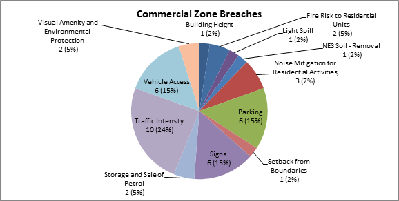
Of the sample of 169
breaches, 41 related to the Commercial Zone. Figure 15 shows that the
majority of consents were related to traffic, parking, and access related
matters (54%) and breaches to sign rules (15%). A number of consents related to
a change of use to an activity which required additional parking.
With respect to the
Traffic Intensity rule, these breaches related to activities and their scale
generating more than expected traffic movements. In terms of vehicle access,
these breaches related to activities which proposed both increases and
decreases to minimum and maximum carriageways widths of the Plan.
Figure
16 - Industrial Zone Breaches
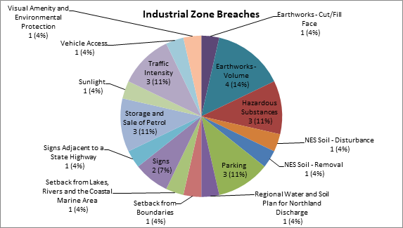
Of the sample of 169
breaches, 28 related to the Industrial Zone. Similar to the Commercial Zone,
breaches related to traffic, parking, and access were common (26%). Other breaches
were focused around hazardous substances, the storage and sale of petrol, and
earthworks (36%).
Table 6 -
Assessment of Environmental Outcomes Expected
|
Environmental
Outcome(s) Expected
|
Key
Observations: Effectiveness
|
|
Urban
Environment
|
|
7.2.1 Urban areas
developed in a manner that promotes sustainable management of natural and
physical resources, while preserving the distinctive character and amenity of
each area.
7.2.2 Urban areas
where a wide range of activities are provided for in a manner which ensures
that adverse effects on the environment are avoided, remedied or mitigated.
7.2.3 Urban areas
containing a variety of residential and non-residential environments,
providing for a level of amenity which is appropriate to the particular environment.
|
To what extent have
the policies and methods been implemented?
The majority of
policies are implemented through the District Plan, by way of zoning and
regulatory rules. These are applied in the Residential, Commercial and
Industrial Zones. Their implementation is largely dependent on the activity
proposed. Since 2012 the most common single breaches of the plan were to the
sunlight, scale of activities and coastal hazard 2 rules. Overall, there have
been 169 different rule breaches in the Urban Environment, canvassing both
zone and district wide rules. The top five breaches overall include:
· Traffic Intensity
& Sunlight;
· Scale of Activities
& Parking; and
· Coastal Hazard 2.
Other methods relate
to the promotion and development of Mainstreet programmes, bylaws,
investigations and studies, education, and best practice principles.
Mainstreet initiatives have been undertaken throughout the district to
improve the character and amenity of the public realm. Bylaws and
investigations relating to water storage is a very relevant issue. Council is
currently working with communities to provide for greater water resilience
throughout the District. While Low Impact Design principles have been
strengthened through Plan Change 17, education and awareness for them have
not accompanied the changes. The extent of implementation of policies and
methods is dependent on the volume of development that occurs in the
District. In the Urban Environment most, if not all, of the methods would
have been implemented either as a means to influence activities to be
permitted, or through resource consent processes.
To what extent have
the outcomes been achieved?
As it is considered
that most, if not all, of the policies and methods have been implemented in
the Urban Environment, it could be argued that most of the outcomes should be
achieved. However, as noted in section x, the ability of the plan to deliver
and influence the achievement of outcomes is not as strong as it could be.
This is largely because although policies and methods have been implemented,
they themselves may not be the most efficient and effective means to deliver
those outcomes. The efficacy of particular rules are noted in section x
below. This highlights that although rules are being implemented, they could
be improved to advance the outcomes in a more cost effective way.
Evaluating the
achievement of outcomes necessitates a move away from assessing consent
volumes to analysis of resource consent conditions. This enables an insight
into how the Plan influences development on the ground. The Urban Environment
outcomes represent the overall vision that Council intended with respect to
the Residential, Commercial and Industrial Zones.
Fifteen resource
consents were analysed to highlight the extent to which outcomes were being
achieved. Five resource consents from each zone were selected, with the
number of breaches and conditions imposed, and their activity status being
identified. Conditions were analysed to understand their contribution to the
grouped themes of the Urban Environment. This assessment helps to understand
whether conditions imposed relate to intended outcomes. This is found in
Appendix X of this report.
Overall, five
consents were processed as restricted discretionary consents and the
remainder as discretionary. A total of 41 breaches were noted with 65
corresponding conditions of consent. Of the conditions of consent, 15 (23%)
related to the theme of Provision of Infrastructure, 17 (26%) related to
Character & Amenity, and 33 (51%) related to Reverse Sensitivity
outcomes. Therefore, this limited assessment shows that the conditions
imposed through the resource consent process are manifesting in on the ground
developments that contribute to the Environment’s intended outcomes, with
a focus on reverse sensitivity outcomes.
This assessment also
links back to the critique of the internal consistency of the Plan. This
found, among other things, that the Plan as currently written tends to focus
on reverse sensitivity effects as opposed to the other themes. In terms of
resource consent conditions and their contribution to expected outcomes, this
critique seems to be substantiated by the analysis above.
|
|
Residential
Zone
|
|
7.6.2.1 Residential
areas containing a range of activities that are compatible, in terms of their
effects, with the predominant residential use and character of those areas.
|
To what extent have
the policies and methods been implemented?
All of the policies
are implemented by district plan rules and zoning. With respect to stormwater
disposal systems, alongside zone rules are Northland Regional Council
requirements with respect to discharges. The most common rule breached and
therefore the most used methods include the sunlight, scale of activities,
coastal hazard 2, parking and setback from boundaries rule.
Of the 17 permitted
activity rules only 10 were breached over the sample period. There were also
a number of breaches to Chapter 12 rules, largely related to earthworks,
hazards and the NES. The rules not breached included the Relocated Buildings,
Building Height, Outdoor Activities, Visual Amenity, Hours of Operation,
Keeping of Animals, Noise and Helicopter Landing Area rules. A number of the
rules above would not be breached by typical residential development, and
Council’s awareness of non-compliance would largely come about through
complaints.
Additionally,
development would also be swayed by other rules which have been breached more
occasionally. For example, the sunlight rule would limit the extent of a
buildings height, and therefore may also be a factor in reducing the rules
implementation. In some circumstances, the fact that rules have not been
implemented also adds to the outcomes intended. For example, the lack of
consent for helicopter landing areas and factory farms is positive for the
zone.
With respect to the
extent of implementation, it is clear that the majority of methods was
implemented and therefore so was the majority of policies.
To what extent have
the outcomes been achieved?
The Residential Zone
consents included 19 breaches with 19 associated conditions. The breakdown of
conditions was similar to the overall total, with reverse sensitivity related
conditions being imposed more than the others. The internal consistency test
in section x noted that the Plan had a strong influence on achieving the
intended outcomes. The scope and nature of conditions imposed seems to
reiterate this assessment.
For example, consent
conditions related to reverse sensitivity and character and amenity in the
zone reflected a desire to limit or mitigate effects from the activity
proposed on other land uses within the area. This was achieved through
various outlets such as limits on hours of operation, screening, and
stormwater and silt control measures
|
|
Commercial
Zone
|
|
7.7.2.1 Commercial
areas containing a wide range of activities, contributing to the everyday
needs and well being of the communities they serve.
7.7.2.2 Commercial
areas that are subject to environmental controls to protect their amenity and
that of adjoining areas, and which avoid, remedy or mitigate adverse effects
on the natural and physical resources of the District.
|
To what extent have
the policies and methods been implemented?
The most common
rules breached in the Commercial Zone related to traffic, parking, vehicle
access and signs. Similar to above, all policies are implemented by way
of zone rules and zoning. Of the 12 permitted activity rules, 6 were breached
over the sample period. Methods not implemented include the Sunlight, Keeping
of Animals, Noise, Roof Pitch, Stormwater, and Helicopter Landing Area
rules. While there were breaches to Chapter 12 rules, this wasn’t
as pronounced as in the Residential Zone. The Sunlight, Roof Pitch and
Stormwater rules have criteria related to when they apply. Their lack of
implementation can relate to these criteria not being satisfied when
development is undertaken. Although not all methods were implemented,
similar to the conclusion found in the Residential zone, the lack of
implementation isn’t considered to be to the detriment of the zones
intended outcomes. Rather, the lack of differentiation across the Industrial
and Commercial zone is of concern.
To what extent have
the outcomes been achieved?
The Commercial Zone
consents included 11 breaches with 11 associated conditions. The breakdown
was different to the overall total and Residential Zone, with character and
amenity related conditions being imposed more than others.
The internal
consistency appraisal for the Commercial and Industrial Zone recognised that
their frameworks had a moderate-poor influence on achieving the intended
outcomes. A key critique included a lack of rule differentiation. This
deficiency enables both commercial and industrial activities to co-exist
within each zone without many constraints. The effectiveness of the zone
provisions are limited by this deficiency.
Notwithstanding,
observations can be provided that further articulate the issues noted above.
As a result of the deficiency, when commercial activities enter into areas
zoned industrial, pressure is placed on industrial activities to locate
elsewhere. Historically, this has been the Rural Production Zone. This in
turn creates further tensions between industrial uses and bona fide rural
uses. A historic example includes big box retail establishing in Waipapa and
acting as an anchor for further retail and service industries, taking up
finite industrial zoned land. A more recent example includes retail
operations establishing in Kaitaia posing further issues regarding
urban form and design.
The Waipapa example
highlights that while the Commercial and Industrial Zone provides for a wide
range of activities, this is at the detriment, over time to the wellbeing of
the communities they serve. From a provision of infrastructure perspective,
areas zoned and appropriately serviced for industrial activities are taken up
by activities which will not utilise the services to the level intended. From
a character and amenity perspective, the underlying characteristics of
industrial areas may not be entirely consistent with the look and feel of
retail areas which can be established. This ultimately leads to pressures for
industrial uses to locate elsewhere, as there are internal conflicts between
particular commercial and industrial activities and the land once designate
for their use is no longer appropriate. The same deductions can be made for
the Commercial Zone; however this occurrence is yet to occur in a similar
manner to that seen above.
Another matter to
acknowledge is the potential for residential development in both the
Commercial and Industrial Zones. Both the Commercial and Industrial
Zone do not contain a Residential Intensity rule and high density development
may be achieved with consideration only given to noise mitigation measures.
No consideration is given to amenity related outcomes such as improved health
and well being through matters such as outdoor living space, privacy, and
outlook rules. This links back to the critique made in earlier assessments
(See section X) with respect to the policy framework being responsive to one
outcome over the others.
|
|
Industrial
Zone
|
|
7.8.2.1 Industrial
areas contributing a wide range of activities that are mutually compatible in
terms of their environmental effects, and which contribute to the needs and
well being of the people of the District.
7.8.2.2
Environmental controls that take account of the needs of industry but also
ensure that the amenity of adjacent areas, and the sustainability of natural
and physical resources in the District, is safeguarded.
|
To what extent have
the policies and methods been implemented?
The Industrial Zone
consents included 17 breaches with 32 associated conditions. The breakdown
was similar to the overall total and Residential Zone, with reverse
sensitivity related conditions being imposed more than the others. The number
of resource consents and conditions imposed relating to earthworks within the
Zone is considered to be an anomaly when considered against the Commercial
Zone. While the Industrial Zone had 5 related consents, the Commercial Zone
had none. The two zones are very similar in every other aspect and it is
surprising that the threshold between the two are
Again, policies are
largely implemented through zone rules and zoning. Stormwater disposal
systems incorporating Low Impact Design have both regulatory and
non-regulatory methods to achieve them, although as stated, Council has not
recently been proactively educating the public on the specific benefits of
Low Impact Design.
Only 3 out of 10
zone rules were implemented during the sample period, although a number of
Chapter 12 rules were breached. Like the Residential zone these related to
earthworks and NES. Methods not breached included the Sunlight, Noise
Mitigation for Residential Activities, Keeping of Animals, Noise, Building
Height, Stormwater, and Helicopter Landing Area. Therefore, typical
industrial activities were of a nature that did not include aspects to which
the rules manage.
The lack of
implementation relates to the nature of the activity proposed but also to the
resource management ethos to have less regulatory intervention. As noted
above, the lack of methods, and their differentiation, can be to the
detriment of the outcomes intended for the areas.
To what extent have
the outcomes been achieved?
See reasoning
provided in Commercial Zone section above.
|
Table 7
- Cost Benefit Analysis of Rules
|
Rule(s)
|
Benefits
|
Costs
|
Is the
rule efficient?
|
|
Sunlight
|
· The rule is a key factor in
determining access to sunlight and daylight which people value for various
reasons, for example health and warmth.
· The rule ensures sunlight is not
blocked by buildings on adjacent sites, unless written approval is given. It is
necessary to provide a threshold which requires buildings to fall within an
angle which permits sunlight on to the site.
· The rule provides for privacy and
reduces the visual dominance of a building.
· Written approval by affected
neighbours is usually provided and therefore they are the arbiter of their
own value on amenity, privacy, and sunlight/daylight admission.
|
· The rule does not acknowledge that tighter
controls are necessary for southern boundaries relative to northern ones.
Buildings located close to the southern boundary are likely to have a greater
effect on neighbouring properties. The need to avoid or reduce shading
effects is greatest in winter when the sun is at its lowest trajectories.
· Potential changes to the rule may reduce,
depending on the buildings location, the need for resource consent, whilst
improving the benefits of increased sunlight for all.
· Average costs are known to be $1,271 per
consent.
· Written approval by affected
neighbours is usually required for sunlight breaches. Where this cannot be
supplied, the notification process is usually instigated.
|
· The rule should
acknowledge different levels of daylight admission relative to the buildings
location. This would influence design and siting of buildings and create
greater benefits for residential areas, particularly south facing sites.
· From a provision of
amenity perspective, the rule is not considered efficient.
|
|
Scale of Activities
|
· The rule seeks to manage the amount of
people on a site at any one time and the implications that can have in terms
of:
o noise, hours of operation, visual amenity
(by way of increased building scale), traffic movement, and impacts on water,
wastewater and stormwater systems.
· Key rule in Residential zone to keep
activities consistent with residential character, scale, and nature
|
· Ability to effectively monitor and enforce
the rule, particularly with respect to the 60 day exemption clause.
· Average costs are known to be $1,121 per
consent.
|
· On balance, the rule is
considered efficient, but could be improved for the purposes of enhanced
monitoring and enforcement.
|
|
Coastal Hazard 2
|
· The rule seeks to reduce the threat of
natural hazards to life, property and the environment.
|
· Accuracy of information;
· Average costs are known to be $1,441 per
consent.
|
· The rule helps both
council and landowners reduce risks from natural hazards.
· Information is not, and
never will be, definitive. New information comes to light on a periodic basis
and this will constantly test efficiency.
· The Proposed Regional
Policy Statement for Northlands’ (PRPS) proposed methods relating to
hazards suggest that the rule may be inefficient. The PRPS has included
methods which seek to increase minimum floor levels within the district.
Minimum floor level requirements are not found within the current Plan, but
in Council’s engineering standards. These factors suggest that the
current rule is inefficient.
|
|
Traffic, Parking and
Access
|
Breaches to the
traffic, parking and access standards of the Plan were common in the Urban
Environment, particularly the Commercial and Industrial Zones. These
provisions provide a means to manage the scale and intensity of activities
and therefore seek to reduce the occurrence of reverse sensitivity and
effects on character and amenity. They also provide a means for the
evaluation of impacts on the roading network and associated infrastructure.
Therefore, the provisions are very relevant to the Urban Environment and the
outcomes foreseen by the Plan. It has already been determined that these
provisions are not the most efficient means to achieve the Plans expected
outcomes. Council has initiated a proposed plan change 20 – traffic,
parking and access to make the policy framework and suite of rules more
effective and efficient
As an example, the
section 32 document for the plan change notes with respect to traffic
regulation that ‘in some cases resource consents have been required
because figures in Appendix 3A are much higher than actual traffic
generation. This is a process which places unnecessary costs on
landowners”[13].
With respect to parking and access, similar outcomes have been found during
the section 32 process. The proposed changes provide an avenue to increase
the efficacy of traffic, parking and access regulations in the Plan. The
proposed plan change was notified on the 20th May 2015 and
submissions from the public will provide further information regarding the
proposal and its efficiency and therefore this report does not seek to
comment any further on those matters.
|
4.3 Rural Sustainability
The ‘Rural
Environment’ made up of the Rural Production (456,052.8ha or 69.98%),
Rural Living (2,625.2ha or 0.40%), and Minerals (1,017.6ha or 0.16%) zone
accounts for 70.54% of the District’s land mass.
The average lot size for
the Rural Living Zone was 1.24ha, which suggests latent potential for
development and growth in this area.
Amongst the findings of
the research was the conclusion that the ad hoc development of commercial and
industrial activities can lead to an increased risk of reverse sensitivity and
land use incompatibility; and potential for adverse effects on amenity values
associated with the rural environment.
Key
observations relating to the internal consistency of the Rural Living Zone are
considered in the table below. The internal consistency table assesses the
influence the Plan has in providing for the outcomes intended. In summary, the
table below highlights that the Plan has a strong influence in being able
to achieve its intended outcomes. The table finishes with a list of generic
recommendations that can be used to enhance internal consistency.
Table 8
- Internal Consistency
|
Rural Living Zone: Environmental Outcomes Expected
|
Relevant Theme
|
Internal Consistency
|
Summary of Key Observations
|
|
8.7.2.1 A Rural
Living Zone where residential living on small rural lots is compatible with
those other rural activities that have an emphasis on production rather than
lifestyle.
|
Reverse
Sensitivity
Character,
Privacy and Amenity
|
Strong
|
The objectives and policies are quite strong and explicit with
respect to the outcome.
Provisions are similar to those found in the Residential Zone,
with slight differences to cater to the effects of adjacent and adjoining
productive rural activities and the special amenity features along Kerikeri
Road.
|
|
8.7.2.2 A Rural
Living Zone where the controls on the activities ensure a high standard of
privacy and amenity for residential activities.
|
Character,
Privacy and Amenity
|
Strong
|
Again the
objective and policies are strong with respect to the outcome. Controls
around sunlight, stormwater management, building coverage and setbacks for
example, are all more restrictive than those found in the Residential zone.
A similar
TIF, screening for neighbours and hours of operation rule also applies which
intend to limit the scale of commercial activities. However, a ‘high
standard’ has not been defined and therefore, it is hard to establish
what this might mean
|
|
8.7.2.3 A Rural
Living Zone where activities are self sufficient in terms of water supply,
sewerage and drainage, while not causing adverse effects on the environment.
|
On site
Provision of Infrastructure.
|
Strong
|
The Plans
ability to influence this outcome is related to density, stormwater
management, and building coverage standards. Where activities are permitted,
the Building and Drainage Act are further influencing factors.
Further
explanation is required to understand the impacts that site servicing can
have on areas considered appropriate for urban zoning and its subsequent
potential for infill development and intensification and effects of on
productive uses.
|
|
General
Comments for Future Review:
|
|
· Clear references
should be established in order to easily identify the relationship between
Issues, Objectives, Policies, Methods and Expected Outcomes.
·
|
4.3.1
Development Activity
Figure 17 shows resource consents from
2007-2015 located in the Rural Living Zone. This is some 362 resource consents.
Land-use (45%), subdivision (31%), combined applications (7%) and variations
(10%) were the most common.
Figure 17 - Rural
Living Consents
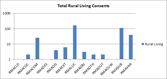
Figure 18 below highlights where resource
consents have been issued throughout the district. The majority of consents
were issued in the Kerikeri and Northern Communities. A fair proportion of all
Rural Living Zone land is located in these areas as opposed to the Kaikohe and
Hokianga Communities where activity and zoned land is lower. The figures mirror
the Urban Environment development trends which highlight similar trends.
Figure 18 - Rural
Living Consents by Community
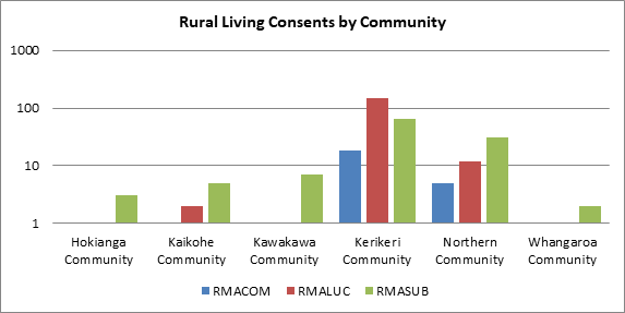
In the Zone there has
historically been more subdivision activity as opposed to land use activity.
This changed in 2012. Overall, land use consents issued have remained,
more or less, steady. The peak for both types of applications were in 2008,
there has been a gradual decrease in numbers since this period in time.
Figure 19 - Rural
Envronment Consents
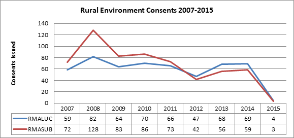
A sample of 51 consents by
breach type is shown below. This included a total of 92 rule breaches to the
Plan. This assessment helps to understand whether land use consents have been
growth related i.e and increase in scale of a building, or technical i.e greater
parking requirements as a result of a change of use.
Figure 20 - Rural
Living Zone Breaches
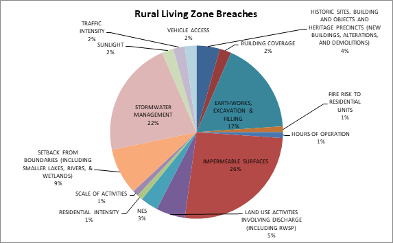
Breaches to the previous
rule Impermeable Surface and current Stormwater Management rule accounted for
over 50% of the rule breaches within the Zone over the sample. Other frequent
breaches included earthworks and setback from boundaries rules’.
Table 9
- Assessment of Environmental Outcomes Expected
|
Environmental
Outcome(s) Expected
|
Key
Observations: Effectiveness
|
|
Rural
Living Zone
|
|
8.7.2.1 A Rural Living Zone
where residential living on small rural lots is compatible with those other
rural activities that have an emphasis on production rather than lifestyle.
8.7.2.2 A Rural Living Zone
where the controls on the activities ensure a high standard of privacy and
amenity for residential activities.
8.7.2.3 A Rural Living Zone
where activities are self sufficient in terms of water supply, sewerage and
drainage, while not causing adverse effects on the environment.
|
To what extent have the
policies and methods been implemented?
Policies are largely
implemented through zoning and rules. Servicing requirements are also managed
outside of the RMA framework by other legislation such as the Building and
Drainage Act. The most common rule breached and therefore the most used
methods include the stormwater management (and previously impermeable surface
rule), setback from boundaries, and earthworks rules.
Of the 13 permitted
activity rules, 7 were breached over the sample period. This included the
sunlight, scale of activities, traffic intensity, setback from boundaries,
building coverage, residential intensity and stormwater management rules.
Eight Chapter 12 rules were breached which related to earthworks, heritage,
access, discharge, fire risk, and setback from waterways. The rules not
breached included the building height, screening for neighbours, keeping of
animals, and helicopter landing area rules. A number of the rules above would
not be breached by typical development, and Council’s awareness of
non-compliance would largely come about through complaints.
With respect to the
extent of implementation, it is clear that a number of methods, and therefore
policies, were implemented, which related to typical rural residential
development.
To what extent have
the outcomes been achieved?
A sample of 10
resource consents have been analysed to examine the extent to which outcomes
have been achieved. Conditions were analysed to understand their contribution
to the grouped themes of the Urban Environment. This assessment helps to
understand whether conditions imposed relate to intended outcomes.
Of the consents, 5
were processed as a Discretionary Activity, 4 as a Restricted Discretionary
Activity, and 1 as a Controlled Activity. A total of 22 breaches were noted
with 60 corresponding conditions of consent. Of the consents, 7 (50%) related
to the theme of On-Site Provision of Infrastructure, 2 (14%) related to
Character, Privacy and Amenity, and 5 (36%) related to Reverse Sensitivity
outcomes. A number of conditions of consent related to a combination of both
Reverse Sensitivity and On Site Provision of Infrastructure themes. Some
activities, and their associated conditions, canvassed all themes.
With respect to
outcome 8.7.2.1, conditions of consent included, for example, restrictions on
hours of operation, screening and landscape planting requirements, and silt
and sedimentation controls. However, the requirements were not necessarily
related to the compatibility of rural productive activities, rather, for
residential activities. The interface between the Rural Production Zone and
the Rural Living Zone is very important to manage. The Plan has a number of
rules, including setback and screening to reduce potential effects. While the
rules themselves are not being implemented regularly, conditions of consent
can still be adopted that recognise reverse sensitivity outcomes. The
assessment criteria for the zone are considered to be very effective in lieu
of the rules themselves being breached.
Breaches relating to
character, privacy and amenity were not as abundant as the others. However
the theme is closely related to Reverse Sensitivity. Related conditions
included limits on the amount of signage, particular finishes for cladding,
roofing, and windows and the implementation of landscape plans. These
impositions, as well as those examples seen above for reverse sensitivity,
are all consistent with the outcome and its expectation of a ‘high
level of privacy and amenity’.
A number of
conditions were imposed relating to outcome 8.7.2.3. Since becoming operative
changes to the previous Impermeable Surfaces rule through Plan Change 17,
resulted in two new rules; Stormwater Management and Building Coverage.
Figure 20 above has identified that the Stormwater Management rule has been
one of the most frequently breached rules since becoming operative in
February 2015. A number of conditions relating to the theme included the
provision of stormwater detention tanks, installation of waste interceptor
traps, and upgrade of wastewater systems.
All dwellings in the
Zone are required to provide a TP58 report alongside building consent
applications which set out how on site treatment and disposal of sewage from
domestic sources are to be managed. In terms of provision of water, this is
dictated by personal preferences and in some instances, building act
processes. The definition of Impermeable Surfaces within the Plan exempts 20m2
from the Stormwater Management rule calculation for the provision of on-site
water tanks.
Overall, with
respect to outcome 8.7.2.3 there are a number of both resource management,
and other associated, mechanisms that help to achieve the expected outcome.
|
Table 10
- Cost Benefit Analysis of Rules
|
Rule(s)
|
Benefits
|
Costs
|
Is the rule
efficient?
|
|
Excavation and
Filling
|
· The earthworks rules
attempt to ‘avoid, remedy, or mitigate adverse effects of excavation
and filling activities such as erosion, loss of soil structure due to
disturbance or compaction, water logging and loss of visual amenity’[14].
· Earthworks Bylaw
captures small scale works that need not be assessed via the resource consent
process.
|
· Perceived
inconsistency and duplication with Regional Council rules.
· Thresholds may not
be appropriate in all Zones. For example, in the Industrial Zone there were a
number of consents related to excavation and filling. The threshold is the
same as that found for the Residential Zone.
· Unintended
consequences through subdivision process – ground level changes as a
controlled activity..
|
· On balance the rules
are considered inefficient. While compliance costs could not be
substantiated, only earthworks of scale require resource consent.
· The thresholds for
the Industrial zone may require some further attention as detailed earlier.
· Duplication and
consistency questions can be addressed via the review of both the District
and Regional Plans, which are set to occur over the next couple of years.
|
|
Setback from
Boundaries
|
· Ensure adequate
sunlight admission to buildings, accessibility along all sides of a site,
reduces the visual dominance of buildings, and provides a degree of visual
and aural privacy.
|
· The requirement for
a continuous shelterbelt where Rural Living sites adjoin Rural Production and
Minerals Zones seems misplaced in the rule. The implementation of this aspect
of the rule is also unknown.
· Implementation of
rules relating to setback from Rural Production and Minerals Zone are
unknown.
· As a transition
zone, the impacts of setback rules (alongside other rules) may limit the
potential for infill development.
|
· Data relating to the
implementation of the rule has, to date, only captured information on clauses
(a) & (d). Compliance costs relating to individual breaches are also not
available. Without such information it is hard to assess efficiency.
· The rule provides
for outcomes related to the themes of Character, Privacy and Amenity and
Reverse Sensitivity.
· Overall, it is
considered that the rule is neutral with respect to efficiency.
|
|
Stormwater
Management
|
· Attempts to address
the effects of stormwater run-off which can result in flooding, erosion and
the uncontrolled release of pollutants into waterways.
|
· More aspects
considered ‘impermeable’ through definition change and therefore
potential for more resource consents.
· Average costs
regarding a breach of the rule equated to $1,483.35.
|
· The Stormwater Management rule has been
operative for less than 6 months and to come to substantive conclusions
regarding the rule is premature. Therefore the provisions are considered as
neutral at present.
|
Further preliminary
consultation on a suite of rural provisions followed, including:
§ 19 July 2012 - the issue of a working draft of the
proposed plan change to a targeted sector group, including agencies,
practitioners and farm sector organisations seeking feedback to draft set of provisions
§ 31 October 2012 – Public notification of draft
Proposed Plan Change, including full page information page in local media, and
supported by representation and sector and community meetings to discuss draft
plan change.
In addition to these processes,
Council representatives have held discussions and meeting with individuals and
representative groups and Councillor workshops to explore the ends and means
associated with the rural provisions.
The feedback provided from
these processes included the following:
§ Recognition that more controls are needed for the zone to
manage potentially incompatible land uses (e.g. child care centres alongside
orchards);
§ some concerns over establishment of commercial and
industrial land uses not expected for the Rural Production Zone –
preference that industrial land uses be located in industrial zones;
§ some industries and services have a functional need to be
in the Rural Production Zone and require differentiation in the policy
framework;
§ the Rural Production Zone is a working environment and
amenity should be a lower order consideration than productive enterprise;
§ divergent attitudes from community and landowners over
specific amenity values rules such as screening form road frontages;
§ requests from rural sector groups and elected
representatives for more certainty for farming and horticulture through
expansion of the exemptions available to farming related industry, structures
and processes;
§ support from the NZTA for the reduction of the Traffic
Intensity thresholds for the Rural Production zone, however concerns from most
other interests regarding this draft measure.
§ strong support for more flexible rural housing provisions
except from Top Energy who raised concerns over district capacity to service
additional demand and horticultural interests who were concerned about the
reverse sensitivity potential from intensification of rural residential
housing.
4.4 Coastal Protection
The coastline in the Far
North is long and varied and contains eight major harbour systems. There are a
number of values attributed to the coastal environment that contribute to its
natural character, which include landscape, ecology, tangata whenua and
historic values. Of the Far North’s 651,709ha, 0.48% of land is zoned
‘Coastal Living’, 0.12% is zoned ‘Coastal Residential’
and 9.44% is zoned General Coastal.
4.1.1 The
drafting of Issues
In a general
sense the issues in the operative District Plan are not concise. If the issue
is not clear then it can lose its impetus. It is the job of the objectives and
policies to address the issues identified, in other words identify the outcome
and how to get there. Best practice denotes that issues should:
§ Identify an environmental problem;
§ be specific ;
§ be succinct ; and
§ include what is being
affected, how it is being affected, and where
Below is a
sample of issues currently identified in the District Plan relating to the
coastal environment and some suggested changes to align with best practice:
1. Issue 1 Coastal
Environment: The Act
requires that the natural character of the coastal environment is preserved.
Natural character can be adversely affected by inappropriate subdivision, use
and development. The preservation of natural character requires that
limitations be placed on further development in some of the District’s
coastal areas. Some areas already compromised by development are not
necessarily appropriate for further development.
Suggested change: Inappropriate
subdivision, use and development is having an adverse affect on the natural
character of the coastal environment.
2. Issue 3 Coastal
Environment: Public
access to and along the coast is insufficient in places and needs to be
enhanced. Public access can have positive effects in terms of recreation,
access to seafood, commercial activity and education. The issue is partly
addressed in Chapter 14 of the Plan and/or in the LTCCP. The Council is
undertaking work to identify areas where access is inadequate and will be
initiating a plan change to give effect to that work. However, public access,
and particularly access by vehicles, can also have negative effects in respect
to public safety and enjoyment of the coast, the protection of indigenous vegetation
and habitats of indigenous species, sensitive cultural and heritage sites and
areas, and damage to landforms).
Suggested
change: There
is currently insufficient public access provided to and along the coastal
environment.
3. Issue 7 Coastal Environment:
Parts of the coastal
environment are subject to natural hazards such as coastal erosion. Careful
management of subdivision, use and development in the coastal environment is
necessary in order that the effects of natural hazards do not cause hardship
and danger to people in the District and to ensure that future subdivision, use
and development generally avoids the need for hazard protection works.
Suggested
change: There
is pressure for subdivision, use and development to locate in areas of the coastal
environment that may be subject to natural hazards, including coastal erosion.
4.4.2 The drafting
of Objectives
The objectives
in the coastal zones have generally been drafted like policies in that they are
explaining the ‘how’. In many instances they talk about avoiding,
remedying and mitigating where they should be denoting the
‘outcome’. Best practice denotes that objectives should:
§ be specific
§ state what is to be achieved
§ relate the objective to the issue
§ write the objective in such a way that people
implementing and monitoring the plan will know when the objective has been met
Below is a
sample of current objectives in the District Plan relating to the coastal
environment and some suggested changes to align with best practice. I have
chosen the objectives that relate to the issues that I have sampled above:
1. Objective 1
Coastal Environment: To
manage coastal areas in a manner that avoids adverse effects from subdivision,
use and development. Where it is not practicable to avoid adverse effects from
subdivision use or development, but it is appropriate for the development to
proceed, adverse effects of subdivision use or development should be remedied
or mitigated.
Suggested
change: Subdivision,
use and development is managed to preserve the natural character of the coastal
environment.
2. Objective 4 Coastal Environment: To
maintain and enhance public access to and along the coast whilst ensuring that
such access does not adversely affect the natural and physical resources of the
coastal environment, including Māori cultural values, and public health
and safety.
Suggested
change: Public
access to and along the coastal environment is maintained and enhanced where is
it is consistent with the values attributed to that environment, including Māori
cultural values, and public health and safety.
3. There is no
Objective that relates to Issue 7 Coastal Environment. As such a suggested
Objective would be:
Subdivision, use and development is
located in areas of the coastal environment that are not subject to natural
hazards
4.4.3 Uncertainty
or lack of clarity
Some of the
language used in the policy framework creates uncertainty and loses the impetus
of what the provisions are attempting to deliver. Examples of this include:
1. Policy 1 Coastal
Environment: That the Council only allows appropriate subdivision, use and
development in the coastal environment. Appropriate subdivision, use and
development is that where the activity generally:
(a) recognises and
provides for those features and elements that contribute to the natural
character of an area that may require preservation, restoration or enhancement;
and…
Use of the language “is where
the activity generally” is non specific in terms of asking
‘where’ or ‘why’. The policy fails to tie down
what appropriate subdivision use and development is, it would be better to use
a word such as “include” as it would incorporate the list that
followed and would also include other items that may be appropriate but missed
off the list.
With respect to the items listed in
the Policy 1 it would appear that (d) avoids, as far as is
practicable, adverse effects which are more than minor on heritage features,
outstanding landscapes, cultural values, significant indigenous vegetation and
significant habitats of indigenous fauna, amenity values of public land and
waters and the natural functions and systems of the coastal environment;
and… is inconsistent with (h) gives effect to the New Zealand
Coastal Policy Statement and the Regional Policy Statement for Northland.
The New Zealand Coastal Policy Statement is clear that adverse effect on
outstanding natural landscapes in the coastal environment is to be avoided[15].
2. Policy 7 Coastal
Environment: To ensure the adverse effects of land-based activities
associated with maritime facilities including mooring areas and boat ramps are
avoided, remedied or mitigated through the provision of adequate services,
including where appropriate:
(a) parking;
(b) rubbish disposal;
(c) waste disposal;
(d) dinghy racks.
The reference in this policy is to
“land-based activities”, which in itself is helpful as examples are
giving to interpret what those land-based activities may include. However, this
policy stems from Issue 9 which references “land-based resources”,
which one can only assume means the same thing as “land-based
activities”. Unfortunately activities and resources can mean entirely
different things. Assuming that they are meant to mean the same thing it
would be preferable to utilise consistent terminology to ensure that there is
no confusion in terms of what the cascade of provisions is attempting to
achieve.
3. Policy 1 General
Coastal: That a wide range of activities be permitted in the General Coastal
Zone, where their effects are compatible with the preservation of the natural
character of the coastal environment.
This policy is drafted in a way where
it is providing for a “wide range of activities” on one hand then
stating that those activities must not contravene the preservation of the
natural character of the coastal environment. The problem is the policy gives
no indication of what may be included in the wide range of activities allowed
as a permitted activity.
4. Issue 1 Coastal
Living: Rural residential development on relatively small lots adjoining the
coast is a popular and appropriate form of development in some parts of
District. However, this can have adverse effects on the natural character and
physical environment of the coastal environment and on water quality.
and Policy 1 Coastal Living: To
provide for the well being of people by enabling low density residential
development to locate in coastal areas where any adverse effects on the
environment of such development are able to be avoided, remedied or
mitigated.
It is not clear that this Issue and
the Policy are addressing the same thing as the language used is not
consistent. Issue 1 is referencing “small lots” and Objective 1 is
concerned with enabling “low density residential”. The problem is
that the Issue is identifying that in some circumstances providing for small
lots on the coast may be appropriate, yet the policy does not reinforce this
and only enables low density development (where appropriate). Further, the term
“relatively small” is not definable.
4.4.4 Repetition
in the provisions
The provisions
that relate to the suite of coastal zones often share a number of the same
issues, as such there are a number of instances where duplication occurs across
the provisions. Examples of this include:
1. Objective 1
General Coastal Zone: To provide for appropriate subdivision, use and
development consistent with the need to preserve its natural character.
Objective 2 General Coastal Zone: - To
preserve the natural character of the coastal environment and protect it from
inappropriate subdivision, use and development.
In my opinion these objectives say the
same thing, only Objective 1 is drafted to make subdivision, use and
development the focus of the provision where in Objective 2 the preservation of
natural character of the coastal environment is the focus. Both versions are
consistent in terms of addressing the issue.
2. The issues
identified within the suite of Coastal zones represent a common theme, only
there are slight variations on each occasion. In essence all are saying:
§ There is pressure for development to be located near the
coast.
§ Not all development is sympathetic to the character of
the coastal environment
§ We need to sustainably manage the development of the
coastal environment
The issues drafted in the coastal
environment are generally more overarching than those identified in the
following coastal zones. I consider that it unnecessary to duplicate what is a
common theme running through all of the coastal issues. A more efficient way,
to avoid duplication, would be to concisely identify the issues in the
‘Coastal Environment’ and just identify objectives and policies
that apply to each of the zones which relate to the issues identified in the
Coastal Environment section.
4.4.5 How the
provisions cascade or link
In some
instances there is no clear cascade or link through the provisions starting
from the Issues, and then moving through the Objectives and Policies. On a
number of occasions the link through to the objectives and polices is weak or
non-existent. Examples of this include:
1. Issue 7 Coastal
Environment: Parts of the coastal environment are subject to natural hazards
such as coastal erosion. Careful management of subdivision, use and development
in the coastal environment is necessary in order that the effects of natural
hazards do not cause hardship and danger to people in the District and to
ensure that future subdivision, use and development generally avoids the need
for hazard protection works.
There is no objective that clearly
addresses this issue. There are generic type objectives that look to minimise
adverse effects and avoid adverse effects from subdivision, use and development
but there is no objective (outcome) that looks to ensure that subdivision, use
and development is managed to ensure that the publics health and safety is
protected. There are two Policies that relate to this issue, there is however
no Environmental Outcome Expected.
2. Issue 11 Coastal
Environment: Activities having a functional need for a coastal location and
access to the sea, such as wharves and boat haul-out facilities, can be
important for the well being of the community. It is important that these
activities are able to be established in a limited range of suitable locations,
recognising that there is potential for conflict between activities with a
functional need and other activities.
There is no clear objective that
addresses this issue. While there is broad generic relevance in Objective 1
there is no specificity in enabling activities that have a functional need to
locate in the coastal environment. Activities that have a functional need to
locate in the coastal environment can be a hotly debated topic and is often
relied upon by infrastructure providers to undertake development and use in
that environment. To provide clarity and suitable direction for this issue a
specific objective is required to address what the term function need
encapsulates. There are also no clear policies addressing this issue. There are
some Policies that address land-based activities and reference examples similar
to that given in the issue, however not all activities that have a functional
need to locate in the coastal environment will be land-based so need to be
addressed as well.
3. In many of the Coastal
zones provisions are double and triple used to enable the cascade from Issues
through to Policies. In some instances it may be appropriate for an Objective
or Policy to be repeated to address more than one Issue. However, in my opinion
many of the provisions are too generic and do not effectively address the
Issues that has been identified, meaning they are unclear in terms of their
purpose. It is important for the cascade to be clear and easy to interpret for
the user of the District Plan.
4.4.6 Resource
consents
A total of 820 resource
consents were received in the Coastal Environment (being the Coastal Living
zone, Coastal Residential zone and the General Coastal zone) between July 2007
and January 31 2015. Figure 21 below details those consents received. In
the Coastal Living (CL) zone there were 300 consents, in the Coastal
Residential (CR) zone there were 190, and in the General Coastal (GC) zone
there were 330. Land use consents made up the majority of applications
accounting for 65%.
Figure 21 -
Coastal Resource Consents
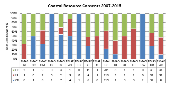
Figure 22 -
Coastal Resource Consents Issued
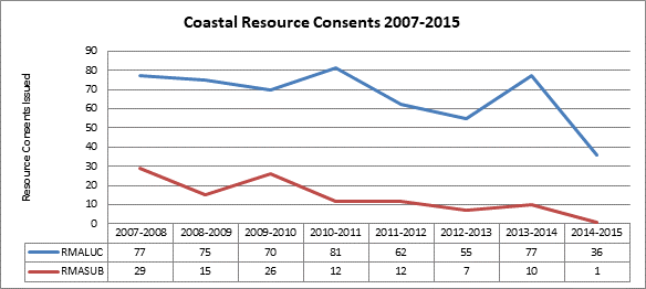
Since 2007, the Coastal
Environment has consistently had more land use consent applications issued
compared with subdivision consent applications. In general subdivision signals
new development and growth and it is closely aligned with the prevailing
economic climate. As the economy slows there is less impetus for growth.
However, despite subdivision consents having slowed substantially since 2007,
there has been a steady flow of land use consents which suggests that
activities such as infill development, additions/alterations, and changes of
use have still occurred over that period.
4.4.7 Coastal lots
issued
The number of lots issued
is directly related to the number of subdivision consents that have been issues
since 2007. As already identified, the number of subdivision application has
slowed. However, this statistic alone does not create the entire picture as it
does not elaborate on the number of lots that have been established through a
subdivision consent application. Figure 23 below identifies the number
of lots that have been established through the subdivision consents dating back
to 2007. The graph clearly shows that the number of lots that have been created
is comparable to the slow down of consents issued for subdivision.
Figure 23 -
Coastal Environment Lots Issued
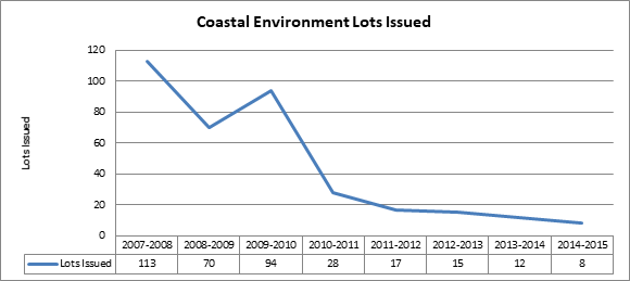
4.4.8 Breaches of resource consent
The breaches identified in
the figures below may help us better understand the nature of the land use
consent applications since 2007 and whether they have been growth related i.e
an increase in scale of a building, or technical i.e greater parking requirements
as a result of a change of use. Figures 24 – 26 identify a total
of 232 breaches to the relevant rules in the District Plan from the time
records area available (2013 – 2015). This data may assist in determining
whether rules most commonly breached are the most efficient and effective means
of meeting the relevant policies, objectives and environmental outcomes
expected.
Figure 24 - : Coastal
Living Breaches
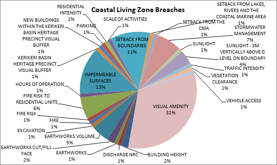
Of the sample of 232
breaches, 99 related to the Coastal Living Zone. Breaches of the Visual Amenity
were by far the most common at 32% followed by Impermeable Surfaces (13%),
Setback from Boundaries (11%), and Stormwater Management (7%). The nature of
the breaches suggests that the degree of development was greater than that
envisaged by the provisions in the plan. Most of the Visual Amenity breaches
related to buildings where, as a permitted activity, control over a new
building as a permitted activity is limited to 50m2 and any
alteration/addition is limited to a 30% in addition to that which currently
exists.
Figure 25 -
Coastal Residential Breaches
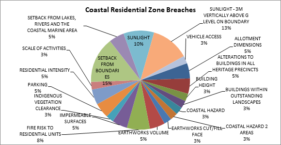
Of the sample of 232
breaches, 40 related to the Coastal Residential Zone. The majority of consents
were related to Sunlight breaches (23%) and Setbacks from Boundaries (15%). The
nature of these breaches suggests that new dwellings or additions/alterations
are struggling to remain in the confines of the site and are therefore
impinging on the sunlight and setback controls.
Figure 26 -
General Coastal Breaches
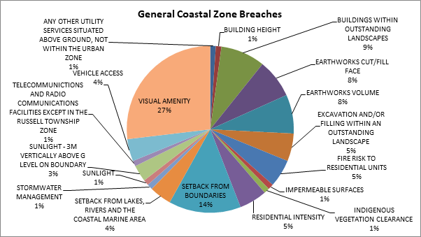
Of the sample of 232
breaches, 93 related to the General Coastal Zone. Breaches of the Visual
Amenity were by far the most common at 27% followed by Setbacks from Boundaries
(14%), Buildings within Outstanding Landscapes (9%) and Earthworks cut/fill
face (8%). Most of the Visual Amenity breaches related to buildings where, as a
permitted activity, control over a new building as a permitted activity is limited
to 50m2 and any alteration/addition is limited to a 30% in addition
to that which currently exists.
4.4.9 Notification
of resource consents
Understanding the approach
to notification is an important factor because it has a direct bearing on the
level of third party involvement and cost of the resource consent process, but
more importantly investment and development behavior with respect to the Plan.
Of the 820 consents that were issued over this period only 3.2% were notified
or limited notified. The lack of notified applications suggests that the
breaches to the controls as they relate to the coastal environment incurred no
more than minor effects on the environment, in other words the breaches were
not significant. This may indicate that the current thresholds that apply in
the coastal zones are too onerous and that these landscapes may be able
withstand further modification. A caveat to this statement would be that
cumulative effects on the coastal environment would become more of a factor and
a greater consideration to any further development rights would need to be
given in these locations.
Figure 27 -
Activity Status of Consents
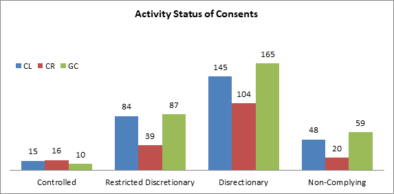
Of the resource consents
that required consent over 50% of them were Discretionary activities. In most
instances this activity status would have been triggered because applications
failed to complying with one or more of the standards for permitted, controlled
or restricted discretionary activities.
4.5 Outstanding Landscapes
Of the Far North’s
651,709ha, 143621.6ha or 22% of land is identified on the Outstanding
Landscapes resource mapping. This mapping was the result of an assessment
undertaken by consultants LA4 in the mid 1990’s. Of the land identified
as Outstanding Landscape 46.9% is within public ownership and 53.1% is
privately owned.
The District Plan under
section 75(3)[16] of the RMA is
required to give effect to the NZCPS and the RPS.
4.5.1 King Salmon
The Supreme Court issued
what has become commonly known as the ‘King Salmon’ decision[17] on 17 April
2014. The decision contains important guidance on how policies within the NZCPS
are to be interpreted, particularly where policies are prescriptive in their
intent. Policy 15(a) of the NZCPS requires that council planning instruments
shall ‘avoid’ adverse effects on Outstanding Natural Landscapes, which are currently
mapped by FNDC and the Northland Regional Council.
The words in the NZCPS are
clear and directive. Where the word ‘avoid’ is used it means
‘not allow’ or ‘prevent the occurrence of’[18]. King Salmon states that an
‘overall balancing approach’ should not be used when implementing
the directive or prescriptive policies of the NZCPS. In the case of Policy 15
an ‘environmental bottom line’ is created and the adverse effects
cannot be balanced against positive effects through revisiting Part 2 of the
RMA. The following policies in the District Plan are at conflict with the
interpretation of the NZCPS through King salmon decision:
Policy 1 - “That both positive
and adverse effects of development on outstanding natural features and
landscapes be taken into account when assessing applications for resource
consent.
Policy 2 – That activities
avoid, remedy or mitigate significant adverse effects on both the natural and
the cultural values and elements which make up the distinctive character of
outstanding natural features and landscapes.
Policy 3 - That the cumulative effect
of changes to the character of Outstanding Landscapes be taken into account in
assessing applications for resource consent.
Policy 5 - That the adverse visual
effect of built development on outstanding landscapes and ridgelines be
avoided, remedied or mitigated.”
4.5.2 Consistency
of language
“Outstanding
Natural Landscapes” is the term use in section 6(b) of the RMA, in Policy
15(a) of the NZCPS and in the RPS. The District Plan currently uses the term
“Outstanding Landscapes”, which is inconsistent with these higher
order documents. This has the potential to add a layer of confusion as the term
“Outstanding Landscape” is not defined or used anywhere else in any
relevant statutory documents. Consistency of language is important as it
enables the plan user more certainty, in this case when addressing matters of
national importance. The intent of the District Plan provisions is to protect
Outstanding Natural Landscapes, as such the term should remain the same and not
be shortened to a term not consistently used elsewhere.
4.5.3 The drafting
of Issues
Issue 1
identifies Outstanding Natural Landscapes and their capacity to accommodate
change without appreciable ‘visual impact’. Outstanding Natural
Landscapes are identified using a set of values or attributes called the WESI
criteria. There are a number of different values or attributes that may
contribute to a site being identified as ‘outstanding’, it is not
limited to just ‘visual impact’. Instead of just identifying
‘visual impact’ it would be more appropriate to identify the
‘characteristics and qualities’ or the ‘attributes’
that contribute to the values that make up an Outstanding Natural Landscape, as
opposed to just singling out one. This issue would be better drafted to read:
The values attributed to Outstanding
Natural Landscapes and Outstanding Landscape Features have a relatively low
capacity to accommodate change.
Issue 7 as it is framed has no place in this
chapter because Māori cultural landscapes are primarily different to
Outstanding Natural Landscapes. Tangata whenua values are a factor or value to
consider when identifying an Outstanding Natural Landscape, however Māori
cultural landscapes as such are not a section 6b RMA matter (unless they
contribute to the overall values of an Outstanding Natural Landscape).
4.5.4 The drafting
of Objectives
The objectives
in the natural and physical resources chapter have generally been drafted like
policies in that they are explaining the ‘how’. In some instances
they identify avoiding adverse effects where they should be addressing the
‘outcome’. Below is an example of a current objective in the
District Plan relating to Outstanding Landscapes (or Outstanding Natural
Landscapes) and a suggested change to align with best practice. Note that the
protection of Outstanding Landscapes from inappropriate subdivision, use and
development is addressed already in Objective 1 and is repeated in the first
part of Objective 4.
Objective 4 To
avoid adverse effects and to encourage positive effects resulting from land
use, subdivision or development in outstanding landscapes and natural features
and Māori cultural values associated with landscapes.
Suggested
change: Subdivision,
use and development is managed to encourage positive effects in Outstanding
Natural Landscapes, natural features and Māori cultural values associated
with landscapes.
4.5.5 Natural Character of
the Coastal Environment
The
preservation of natural character in the coastal environment and its protection
from inappropriate subdivision, use and development is a requirement in section
6(a) of the RMA and Policy 13(1) of the NZCPS.
No policy framework
currently exists within the District Plan for the preservation of natural
character of the coastal environment and its protection from inappropriate
subdivision, use and development. The natural character areas of the coastal
environment have not previously been mapped by FNDC. The mapping of high and
outstanding natural character has recently been done by Northland Regional
Council. The criteria for establishing these areas are identified in Policy
13(2) of the NZCPS. Inclusion of provisions that relate to the natural character
of the coastal environment could potentially either sit within this chapter or
within the coastal chapter.
4.5.6 Resource
consents
A total of 50 resource
consents were received in relation to Outstanding Landscapes between July 2007
and January 31 2015. Figure 28 below further details in what zones those
resource consents were received. Out of the 50 consents issued only three were
for subdivision, meaning 94% of all applications were land use applications.
The majority of applications were either in the General Coastal zone or the
Rural Production zone. As can be seen in the table below there was a peak of
resource consent applications issued in 2011, from then there has been a steady
decline leading up to 2015.
Figure 28 - Outstanding
Landscape Resource Consents
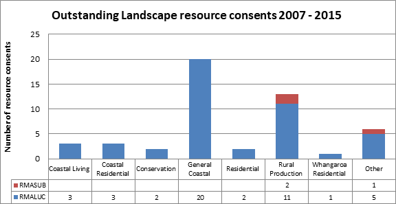
Figure 29 -
Outstanding Natural Landscapes Resource Consents Issued
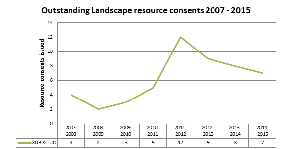
4.5.7 Breaches of
resource consents
The breaches identified in
the figures below may help us better understand the nature of the land use
consent applications since 2007. Figure 30 identifies a total of 21
breaches to the relevant rules in the District Plan from the time records area
available (2013 – 2015). This data may assist in determining whether
rules most commonly breached are the most efficient and effective means of
meeting the relevant policies, objectives and environmental outcomes expected.
Figure 30 -
Outstanding Landscape Breech Data
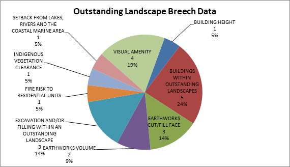
Of the sample of 21
breaches, 37% related to earthworks (being a combination of excavation,
filling, cut/fill face and volume), 24% related to buildings within outstanding
landscapes and 19% related to visual amenity. The nature of the breaches
suggests that the degree of development in these outstanding areas was greater
than that envisaged by the provisions in the plan. While visual amenity is not
a standard addressed in the Outstanding Landscape rules, it is picked up along
with breaches relating to buildings within Outstanding Landscapes in the
General Coastal zone. Where this happens the non habitable threshold for
buildings reduces to 25m2 and resource consent is required for a
habitable dwelling. It therefore is understandable that this is a common breech
of the controls as building a dwelling of any size will require a resource
consent within an Outstanding Landscape.
5.8
Notification of resource consents
Understanding the approach
to notification is an important factor because it has a direct bearing on the
level of third party involvement and cost of the resource consent process, but
more importantly investment and development behavior with respect to the Plan.
Of the 50 consents that were issued over this period only two were notified
applications. The lack of notified applications may suggest that the breaches
to the controls as they relate to Outstanding Natural Landscapes incurred no
more than minor effects on the environment. This may indicate that the current
thresholds that apply in these Outstanding Landscapes are too onerous and that
these landscapes may be able withstand further modification. A caveat to this
statement would be that cumulative effects on the coastal environment would
become more of a factor and a greater consideration to any further development
rights would need to be given in these locations.
Figure 31 -
Activity status of consents
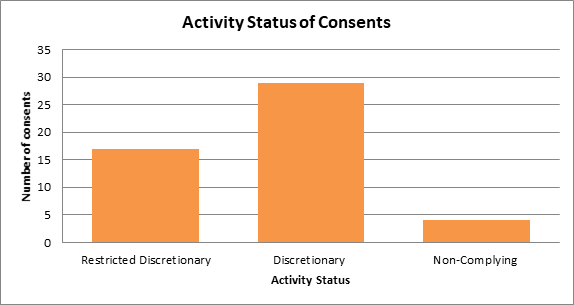
Of the resource consents
that required consent 58% of them were Discretionary activities. Discretionary
activities are activated in the District Plan within Outstanding Landscapes
where applications fail to comply with one or more of the standards for
permitted, controlled or restricted discretionary activities.
4.6 Indigenous Flora and Fauna
The Far North District has
a land area of around 651,709
hectares . Approximately 267,000 hectares of that area (around 40%) comprises
indigenous habitat[19].
Due in part to the relatively large area of indigenous habitat remaining, but
also due to the district’s unique geology, the Far North retains a
diverse suite of ingenious ecosystems and is host to a large variety of native
plants and animals, many of which are found only in the Northland area. In fact
the Northland Regional is commonly referred as a biodiversity hotspot owing to
the diversity of unique ecosystems and associated flora and fauna.
The planning implementing
the indigenous flora and fauna provisions relied heavily on the mapping of
“Significant Natural Areas” undertaking as part of the Department
of Conservation’s Protected Natural Areas Programme (PNA). The use of the
Department’s PNA process for the purpose of identifying significant
natural areas was common practice by Territorial Authorities across the
country, but the process was inherently flawed for the use with RMA planning
documents due to mapping inaccuracies and because the process tended to focus
on the best remaining habitat rather than significant habits in the
context ofs6(c) of the RMA (Maseyk and Gerbeaux 2014[20]).
The new Regional Policy
Statement for Northland (RPS) includes, amongst other things, policies and
methods aimed at maintaining and protecting significant ecological areas and
habitat. The new RPS identifies significant ecological areas as including
modified habitat remnants that are acutely or chronically threatened (sites
where there is less than 20% indigenous cover left)[21].
The total area of land in
the Far North District the falls into the category of acutely or chronically
threatened is approximately 104,422 hectares (see figure 32). Given that nearly half of the
District’s indigenous vegetation is located on private land, one of the
key challenges for the District Plan review process will be developing a Plan
that gives effect to the biodiversity provisions of the RPS whilst achieving
the right balance with regard to the social and economic wellbeing of property
owners.
Figure 32 Acutely and
Chronically threatened environments in the far North District

Most notably, Landcare
Research has completed a large amount of work over the years assessing the
temporal changes in indigenous land cover at a national scale (for example
Walker et al. 2005, Walker et al. 2006, Cieraad et al. 2015). The
work carried out by Cieraad et al. (2015) reports on the most recent
synthesis of land cover changes, providing a national scale assessment of
remaining native biodiversity in New Zealand drawing on the results of updated
spatial datasets of New Zealand land cover. The overall national trend over the
last decade has been one of biodiversity decline.
It should be emphasised
that the work carried out by Landcare provides a national scale picture, and so
it cannot be used to draw direct conclusions for the Far North. However, to
understand the matter further, Landcare Research was commissioned to complete
an assessment of land cover change between 2002 and 2012 using the same spatial
datasets utilised by Cieraad et al. (2015) covering the Far North
District only. The resulting map is provided in Figure 33 below.
Figure 33 - Change in
the percent of Land Environments New Zealand Level 4 environments in indigenous
cover between 2002 and 2012

The work undertaken by
Landcare Research suggests that the natation trend of overall habitat loss is
carried though to the Far North District, with around a 0.5 to 1% decrease of
indigenous vegetation cover along the east coast of the Te Hiku area, and
decline of around 0.5-0.1% throughout the rest of the district.
Whilst the work produced
by Landcare is useful for providing an overall picture of land cover change
throughout the district, it should be noted that there are a number of data
uncertainties with the process used; that is, uncertainty about whether the
changes were actual change on the ground or database corrections or errors.
Nevertheless the work provides the best indication of indigenous land cover
changes over the last decade taking into account the limited information currently
available.
In addition to the above
work, the Land Cover Database version 4[22]
was used to complete an analysis of changes in vegetation cover over the period
of summer 2008/09 (around the time the plan become operative) and summer
20012/13. The results of that analysis indicate that indigenous vegetation
cover throughout the district declined by about 1200 hectares over the four
year assessment period. Results of the analysis by land class type are provided
in Figure 34 below.
Figure 34 - Vegetation
loss in the Far North District between summer 2008/09 and summer 20012/13

4.6.1 Legal
protection
In terms of levels of
formal protection, at a national scale, Cieraad et al. (2015) describe a
pattern of increased levels of protection over habitat types that already
enjoyed good levels of protection; and reduced protection of habitats that were
previously poorly protected and in decline. Changes in protection between 2002
to 2012 are depicted at a district level in Figure 35. That work
suggests that there has been a net increase in protection over the last decade
or so. However, it is not clear if this increase in protection follows the same
polarising trend described by Cieraad et al. (2015); that is, an
increase in protection in those habitats already highly protected.
FNDC has implemented a
policy (# R04/11) to allow for the remission of rates on land subject to
protection for outstanding landscape, cultural, historic or ecological
purposes. The policy was implemented to give effect to Method 12.2.5.13 of the
District Plan, which sets out that FNDC will allow for to the remission or
postponement of rates in areas afforded permanent legal protection through a
covenant or reserve status. Since 2002, the approximate area of covenants
registered with FNDC that give protection to indigenous vegetation is 1,839ha.
Figure 35 -
Change in the percent of Land Environments New Zealand Level 4 environments
legally protected between 2004 and 2012

In addition to the above
area, long-term protection of indigenous habitat on private land is also
secured via Queen Elizabeth II National Trust (QEII) and Nga Rahui Whenua
covenants. These covenants are also subject to rates remission and postponement
policy # R04/11. Data provided by QEII indicate that a total of 187 covenants
are presently registered in the Far North District, covering a total area of
5171 hectares. The total area protected by QEII covenants has nearly doubled
since 2002, at which point 2379 hectares was registered with the Trust. Details
of the types of habitats protected, and the relative areas, are provided in Table
11 below.
Table 11 - QEII
Open Space covenants registered within the Far North District
|
Habitat type
|
No. of
Open Space covenants
|
Surveyed
Area (Ha)
|
|
Coastal/semi-coastal
forest and/or scrubland
|
41
|
802.7
|
|
Coastal/semi-coastal
wetland
|
7
|
259.9
|
|
Coastal/semi-coastal
wetland + forest and/or scrubland
|
8
|
108.0
|
|
Dune
|
2
|
18.4
|
|
Dune + wetland
|
3
|
104.5
|
|
Geological feature
|
1
|
1.5
|
|
Lowland forest
and/or scrubland
|
106
|
3222.8
|
|
Lowland wetland +
forest and/or scrubland
|
14
|
587.4
|
|
Lowland wetland +
forest and/or scrubland
|
5
|
65.9
|
|
Total
|
187
|
5171
|
With Regard to Nga Rahui
Whenua sites, the Ngā Whenua Rāhui Fund provides funds to help
protect indigenous ecosystems on Māori land. Information provided by the
Department of Conservation (which administers the fund), indicates that a total
area of around 6500 hectares of Māori land in the Far North District has gained
protection through the Nga Rahui Whenua process. It is assumed that this land
comprises exclusively of indigenous ecosystems.
QEII covenants, Ngā
Whenua Rāhui protection and covenants registered with FNDC for rates
remission/postponement are the main forms of voluntary legal protection on
private land within the district. Together these protection mechanisms equate
to a total area of around 13500 hectares, which is about 10% of area of
indigenous vegetation located on private land. It is reasonable to assume the
bulk of the FNDC covenants were registered in order to receive the rates
remission or postponement, and so it is possible to conclude that 1839 hectares
of indigenous vegetation on private land has been protected largely through the
implementation of Method 12.2.5.13 of the District Plan. The influence of that
method on the extent of QEII covenants is not so clear because rates remissions
is only one of many reasons why a property owner would seek to protect
indigenous vegetation on their land.
The environmental outcomes
set down in Chapter 12.2 provide a clear expectation in respect of the
maintenance and enhancement of significant vegetation and rare or endemic
plants and animals in addition to improving the extent of formal protection of
indigenous vegetation on private land.
The provisions in Chapter
12.2 place heavy reliance on non-regulatory mechanisms (i.e. “Other
Methods”). However many of these methods have not been implemented; or
were implemented and have since stopped, a key example being the Significant
Natural Areas Committee and associated funding. In this case the Committee was
intended to play a substantial role in developing voluntary means of
maintaining, enhancing and protecting indigenous habitat.
In addition to the limited
implementation of the “Other Methods” contained in Chapter 12.2,
there is insufficient information available to allow for a detailed assessment
of the efficiency and effectiveness of Chapter 12.2. Of particular note is that
there is virtually no information available with regard to the extent of
vegetation clearance being carried out under the permitted activity rules
contained in Chapter 12.2. To put this issue into context, it is worth
considering the extent of the vegetation cleared under the previous permitted
activity framework. Specifically, between 2003 and 2007, following the full
retraction of the first proposed District Plan, the indigenous Flora and Fauna
Chapter of the Plan (then Chapter 11) contained a permitted activity rule that
allowed for the clearance of vegetation on rural production land provided 15
days notice was given to FNDC. Over the period that the rule was in effect FNDC
maintained an effective monitoring process. That process involved commissioning
an ecological assessment and long term monitoring of tracts of permitted
vegetation clearance. Over the four years that the rule was in effect, property
owners notified FNDC of indigenous vegetation clearance totaling 1,200
hectares.
Although the permitted
activity provisions at the time were not particularly useful at promoting the
maintenance of indigenous vegetation on private land, the notification and
monitoring process was at least an effective means of understanding the extent
and type of permitted indigenous vegetation clearance being carried out
throughout the district. In contrast, the permitted activity rules contained in
the current District Plan are substantially more restrictive but do not require
any form on notification by anyone relying on the rules. Consequently, since 2007,
there has been no way of gaining a detailed understanding of the extent or type
of indigenous vegetation being cleared that relies on the permitted activity
rules in Chapter 12.2. This represents a substantial knowledge gap,
particularly taking into account the limited area of vegetation clearance that
has been authorised by resources consents.
In terms of consented
activities, an assessment of resource consents granted between 2007 to 2015
indicates that very little vegetation clearance is being consented. Over that
period, a total of 24 resource consents were issued that allowed for indigenous
vegetation clearance. The vast majority of those authorisations were for
ancillary activities for property developments; that is, very few applications
were for indigenous vegetation clearance only. The total area of vegetation
clearance authorised by these resource consents is 8 hectares. Given that a
total of 1200 hectares was cleared in the fours years between 2003 and 2007 as
a permitted activity (permitted clearance after that time is was not recorded),
it is reasonable to assume that the 8 hectares of consented clearance between
2007 and 2015 represents a minor proportion of actual indigenous vegetation
removal over that period, particularly taken into account the national trend of
overall biodiversity decline.
4.7 Heritage
Under ‘Section 6
Matters of national Importance’ of the RMA, all persons exercising
functions and powers under the Act, shall recognise and provide for 6(e) “the
relationship of Māori and their culture and traditions with their
ancestral lands, water, sites, waahi tapu, and other taonga” and “6(f)
the protection of historic heritage from inappropriate subdivision, use,
and development”.
The Heritage New Zealand
Pouhere Taonga Act 2014 provides that Heritage NZ Pouhere Taonga maintains the
New Zealand Heritage List/Rārangi Kōrero. Inclusion on the list does
not provide automatic protection but it does record the importance of historic
places. The Heritage New Zealand Pouhere Taonga Act 2014 gives legal protection
to archaeological sites.
In 2012 some interim data
gathering was carried out in regard to heritage and report card produced titled
‘Cultural and Historic Heritage’.
The following sections
describe the environmental outcomes expected, the indicators developed to
assess the degree to which the outcomes have been achieved and an analysis of
data available relating to these the indicators.
4.7.1 Chapter 10.9 –
Russell Township Zone
The following indicators
have been developed in an attempt to assess whether or not the environmental
outcomes expected from Chapter 10.9 Russell Township Zone have been achieved.
The outcomes are as follows:
10.9.2
Environmental Outcomes Expected
These
outcomes supplement those set out in Section 10.2.
10.9.2.1 A Russell Township Zone in which activities and
development occur in a way that is compatible with the historic heritage and
amenity values of Russell, and where there are no significant adverse effects
on the environment.
10.9.2.2
The intrinsic character of Russell and its significance as New Zealand’s
oldest European settlement is recognised and preserved by controlling
development within defined boundaries.
|
Indicator(s):
|
Indicator - Number of consents
granted within the Russell Township Zone and the most common rule breach.
Seven consents have been granted
within the Russell Township Zone since 2008. The most common rule breach is
of permitted standard rule 10.9.5.1.5 - Building Scale.
Indicator - Number of consents in
Russell Township Zone which address heritage issues.
Of the seven consents
granted all except one addresses heritage issues as the consents were also
within heritage precinct overlay areas. The most common rule breach is of the
controlled activity rule 12.5A.6.2.2
- Alterations to Buildings in all Heritage Precincts except Kerikeri
Basin.
|
|
Indicator
Date:
|
June 2015
|
|
Explanation:
|
These indicators
outline the number of consents within the Russell Township Zone which control
development in order that it is compatible with the historic heritage and
amenity values of Russell.
|
|
Data
Source:
|
Far North District
Resource Consent Data 2008-2014
|
Comment – The most common rule
breach in the Russell Township Zone is the building scale rule which is
controlling the bulk and scale of the built development within the zone. The
most common heritage precinct rule breach relates to alterations to buildings.
However, it is uncertain if the ‘intrinsic character’ of Russell is
recognised and preserved as this is has not been defined or explained and is
therefore difficult to measure.
4.7.2 Chapter 12.5 – Heritage
The outcomes expected from
Chapter 12.5 – Heritage are listed below as have the indicators which
have been developed in an attempt to assess whether or not the outcomes
expected have been achieved.
12.5.2
Environmental Outcomes Expected
12.5.2.1 Recognition and retention of
the heritage values of identified historic buildings, objects, or features.
|
Indicator(s):
|
Indicator – Number of heritage
buildings, sites and objects in the District Plan.
There are 245 heritage buildings,
sites and objects listed in Appendix 1E - Schedule of Historic Sites,
Buildings and Objects of the Far North District Plan.
In 2010 Plan Change 4 sought to make
amendments to the Far North District Plan schedules. A number of historic
buildings were included in Appendix 1E and modifications will be made to the
district plan resource maps to reflect these changes.
In 2012 Plan Change 11
sought to make further amendments to Appendices 1E - Schedule of Historic Sites,
Buildings and Objects of the District Plan to update the schedule in order to
improve efficiency.
Indicator – Number of heritage
buildings, sites and objects in the New Zealand
Heritage List/Rārangi Kōrero (formerly the Register).
There are 363 historic places,
areas, wāhi tūpuna and wāhi tapu areas in the Far North
District which are on the New Zealand Heritage
List/Rārangi Kōrero (formerly the Register).
|
|
Indicator
Date:
|
June 2015
|
|
Explanation:
|
This indicator
outlines the number of heritage items afforded protection by the District
Plan and the New
Zealand Heritage List/Rārangi Kōrero (formerly the Register)
|
|
Data
Source:
|
Far North District
Plan and New
Zealand Heritage List/Rārangi Kōrero (formerly the Register).
|
Comment - The data indicates that
there are less heritage buildings, sites and objects listed in Appendix 1E of
the District Plan than are identified in the New Zealand Heritage
List/Rārangi Kōrero (formerly the Register). This suggests that more
heritage items may need to be afforded the additional protection of the
district plan as inclusion in the New Zealand Heritage List/Rārangi
Kōrero (formerly the Register) does not provide automatic protection.
12.5.2.2 An improved level of knowledge and understanding of heritage
resources.
|
Indicator(s):
|
Indicator – Number and
distribution of applications to the heritage assistance fund.
Council does not appear to offer a
heritage assistance fund.
Indicator – Education advocacy
work done by council and other organisations in regards to historic heritage.
Council does not have the resources
and does not do any planned education or advocacy work in regard to historic
heritage.
|
|
Indicator
Date:
|
June 2015
|
|
Explanation:
|
Section 12.5.5.17 of the plan
provides that the Council may operate a District Heritage Assistance Fund to
provide grants and low interest loans for resource consents required under
the District Plan and to encourage other conservation work.
|
|
Data
Source:
|
Council records.
|
Comment - Council could and perhaps
should partner with other organisations such as Heritage New Zealand Pouhere
Taonga to and actively plan to do education and advocacy work in regard to
historic heritage.
12.5.2.3 No unnecessary loss of identified notable trees.
|
Indicator(s):
|
Indicator: Number of new notable trees added to
the district plan.
There are 134 notable
trees listed in Appendix 1D – Schedule of Notable Trees of the Far
North District Plan.
Indicator: Number and
distribution of notable trees lost (also a breakdown of reasons why)
In 2010 Plan Change 4
sought to make amendments to the Far North District Plan Schedule of Notable
Trees.
New trees
were added to the Schedule (i.e. trees that meet the Notable Tree assessment
criteria but were not included on the Schedule);
There were
also trees deleted from the schedule. These trees were either physically
removed since being listed on the schedule or it is considered inappropriate
that the tree be included on the schedule.
Corrections
of legal descriptions for existing trees on the schedule to accurately locate
tree/s were also made; and amendments to the District Plan zoning maps to
reflect these changes.
The Schedule of Notable
Trees was introduced in the Far North Proposed District Plan in April 2000.
Since the preparation of this schedule there has been a growing awareness of
a number of trees currently listed that have either died or suffered
significant damage. There are also other trees worthy of inclusion which were
originally omitted from the schedule.
Following
completion of the review the following amendments were made to the plan:
15 trees
currently listed in the Schedule were removed;
28 trees
were in need of immediate remedial work;
A number of
trees were incorrectly located on the District Plan maps; and
10 nominated
trees met the criteria for inclusion in the Schedule of Notable Trees.
A search of
the Monitoring Department complaints process has not identified any notable
trees in the district which have been removed.
|
|
Indicator
Date:
|
June 2015
|
|
Explanation:
|
This indicator
outlines the number of Notable trees afforded protection by the plan.
|
|
Data
Source:
|
Far North District
Plan and Plan Change 4
|
Comment – The formal plan change
process has enabled Council to identify and explain the loss of some notable
trees. Although no loss of notable trees has been identified through the
complaints process it would be necessary to do some checking of this by way of
a sample of the notable trees identified in the schedule or with a regular
check of all notable trees.
12.5.2.4 No unnecessary modification of archaeological sites.
|
Indicator(s):
|
Indicator: Number of archaeological
sites in the District Plan
There are 183
archaeological sites listed in Appendix 1G – Registered Archaeological
Sites of the Far North District Plan.
Indicator: Number of archaeological
sites on the New Zealand Heritage
List/Rārangi Kōrero (formerly the Register);
There are 205 NZAA sites
on the New Zealand Heritage List/Rārangi
Kōrero (formerly the Register).
Indicator: Number of archaeological
sites In the NZAA index
Access to the NZAA Index has not
been achieved although enquiries have been made with NZAA. An investigation
of the NZAA GIS ArchSite indicates that there are a large number of NZAA
recorded archaeological sites in the Far North District. Informal information
obtained from NZ Heritage Pouhere Taonga estimates that there are over 8,000
recorded archaeological sites in Northland (comprising the Far North,
Whangarei and Kaipara districts) and this and others are being recorded all
the time.
|
|
Indicator
Date:
|
June 2015
|
|
Explanation:
|
This indicator
outlines the number of NZAA sites identified within the district plan.
|
|
Data
Source:
|
Far North District
Plan, New
Zealand Heritage List/Rārangi Kōrero (formerly the Register), NZAA
GIS ArchSite
|
Comment – The indicators related to
this outcome may only tell part of the story regarding modification of
archaeological sites. No data has been gathered in regard to consented or
unconsented excavation which may have effects on archaeology. Perhaps we need
to be working more closely with NZ Heritage Pouhere Taonga in order to
determine if the numbers of authorities to modify archaeological sites have
been issued in our district. A review of the outcome and/or indicator may be
required in order to include this dimension.
12.5.2.5 Recognition and retention of the heritage values of
specified areas of Russell, Kohukohu, Mangonui, Kerikeri Basin and Rawene
(which are coastal settlements with related values), and Waimate North and
Pouerua, (which are inland areas with heritage values).
|
Indicator(s):
|
Indicator: Total number of consents
granted within heritage precincts.
The resource consent data below
summarises the number of consents that have been granted within the heritage
precincts identified in the plan:
The Strand: 3
Wellington Street: 2
Christ Church: 5
Mangonui: 4
Kohukohu:) 3
Rawene: 2
Kerikeri Basin: 10
Te Waimate: 2
Pouerua (Pakaraka): 2
Indicator: Total number of consents
granted within Visual Buffer Zones.
The resource consent data indicates
that 10 consents have
been granted within the Kerikeri Basin Heritage Precinct Visual Buffer
overlay.
Note: the indicator
refers to the ‘Visual Buffer Zones’, is this more accurately an
‘overlay’ rather than a zone.
|
|
Indicator
Date:
|
June 2015
|
|
Explanation:
|
These indicators
outline the number of consents within heritage precincts and the Kerikeri
Visual Buffer overlay which control development in order that there is
recognition and retention of the heritage values of the specific precinct.
|
|
Data
Source:
|
Resource consents
data.
|
Comment - A closer examination of
resource consents may be required, particularly in regard to conditions
imposed, in order to determine whether or not the outcome has been achieved. A
review of the outcome may be required to ensure clarity and measurability.
12.5.2.6 Knowledge and understanding of sites of cultural
significance to Māori.
12.5.2.7 Recognition and retention of the Māori values
relating to sites of cultural significance.
|
Indicator(s):
|
Indicator – Number of Sites of
cultural significance to Māori in the District Plan.
There are 332 sites of cultural
significance to Māori in Appendix 1F: Schedule of Sites of Cultural
Significance to Māori, in the District Plan.
Indicator – Number of Sites of
cultural significance to Māori within the District Plan which are water
bodies.
There are 15 sites of cultural
significance to Māori within the District Plan which are water bodies.
Indicator – Number of Sites of
cultural significance to Māori in Iwi and Hapu Management Plans.
While sites of cultural significance
to Māori are referred in the Iwi and Hapu Management Plans lodged with
Council they are not specified in any of the plans.
Indicator – Number and
distribution of Sites of cultural significance to Māori on Iwi and Hapu
GIS.
No data has been obtained to identify
sites of cultural significance to Māori on Iwi and Hapu GIS.
Indicator - Number of Cultural
Impact Assessments conducted as part of a resource consent application where
Tangata Whenua are determined to be an affected party.
Few cultural impact assessments are
provided with resource consent applications. Council’s data base does
not provide a suitable means to record when CIA’s are provided or
required for resource consents.
|
|
Indicator
Date:
|
June 2015
|
|
Explanation:
|
These indicators outline the number
of sites of cultural significance to Māori and
|
|
Data
Source:
|
Council records and
Iwi/Hapu Management Plans.
|
Comment – There is a paucity of
information to determine if these cultural outcomes have been achieved. The outcomes,
indicators and methods of data gathering need to be reviewed in order to
provide clear and measurable outcomes.
12.5.2.8 No unnecessary damage, destruction or modification of
archaeological sites.
This outcome is almost
identical to 12.5.2.4 No unnecessary modification of archaeological sites. See
above for data and assessment.
12.5.2.9 Active involvement by Māori in decision making
about, and management of Sites of Cultural Significance to Māori.
|
Indicator(s):
|
Indicator – Frequency of
consultation on resource consents/ plan changes and frequency of pre
consultation on resource consents.
Consultation with Māori is
undertaken for all plan changes and generally follows the process whereby
Iwi/Hapu Management Plans are assessed to determine if the proposed plan
change is identified as an issue in the plans lodged with Council. All Iwi
are notified about the plan change at the draft notification and full
notification stages of the process. is may be undertaken but is
more likely to be just
Anecdotally and following a
discussion with the Principal planner the number of resource consents that
come in where the applicants have undertaken pre-consultation with Māori
is ‘not very many’. Pre-consultation is likely to have taken
place if the site contained a Site of Cultural Significance to Māori or
had a distinctive figure such as a Pa site.
|
|
Indicator
Date:
|
June 2015
|
|
Explanation:
|
This indicator requires an analysis
of the resource consent process to determine whether or not there is active
involvement of Māori in decision making.
|
|
Data
Source:
|
Council records and
Iwi/Hapu Management Plans.
|
Comment - The process of
consultation on resource consents and plan changes needs to be more clearly
defined in order to ensure active involvement by Māori in decision making.
There are several
‘other methods’ included in the heritage section of the plan that
are worthy of note see below:
Section 12.5.5.12 – The
Council will hold an up to date copy of the NZAA database and will make this
information available to the public.
Comment - The information on the
NZAA database is not currently made available to the public.
Section
12.5.5.13 - Where any person wishes to
protect, maintain or upgrade heritage resources, or to obtain a heritage order
or a Plan Change to the schedule of historic buildings and objects, and in
doing so is required to make application to the Council, consideration will be
given to the waiving of application fees (pursuant to s36 of the Act).
Comment - No information is
available to determine if the waiving of fees for any person wishing to
protect, maintain or upgrade heritage resources, or to obtain a heritage order
or a Plan Change to the schedule of historic buildings and objects.
Section
12.5.5.14 - Where heritage resources
are afforded permanent legal protection through means such as a covenant, an
application may be made to the Council for rates relief according to Council
policy.
Comment - From the information
available it appears that there has been no uptake of the rates relief policy
in regard to heritage resources afforded permanent legal protection through
means such as a covenant
12.5.5.17 - The Council may operate a District Heritage
Assistance Fund to provide grants and low interest loans for resource consents
required under the District Plan and to encourage other conservation work.
Comment - There does not appear to
be a District heritage Fund to provide grants and low interest loans for
resource consents and to encourage other conservation work.
In summary it is
considered that there is insufficient evidence to show whether the above
methods are efficient and overall, there is insufficient data to be able to
assess the efficiency of the plans.
5.2 Submission
on the National Policy Statement for Indigenous Biodiversity
File
Number: A2862144
Author: Emily
Robinson, Policy Planner
Authoriser: Darrell
Sargent, General Manager - Strategic Planning and Policy
Purpose of the Report
To inform the Committee
on Council’s biodiversity planning responsibilities under the Regional
Policy Statement for Northland (RPS) (2016) and to inform the Committee on the
submission Council has prepared on the proposed National Policy Statement for
Indigenous Biodiversity.
Executive Summary
The Draft National Policy Statement for Indigenous
Biodiversity (NPS-IB) was released for consultation in November 2019, with
submissions closing on the 14th March 2020. A submission on the NPS-IB has been
prepared by the District Planning team which is included as an appendix to this
report.
The NPS-IB sets out a
variety of requirements for both territorial and regional authorities,
including the mapping of Significant Natural Areas (SNAs). Council is currently
undertaking this mapping in collaboration with Kaipara and Whangarei District
Councils to identify potential SNAs, under directives from the RPS which is
currently in effect. It is anticipated that if gazetted (expected mid-2020),
the NPS-IB will include a range of additional implementation requirements for
Council to undertake which will have financial and resourcing implications for
Council and for Far North communities.
|
Recommendation
That the Strategy and Policy Committee receive the
report “Submission on the National Policy Statement for Indigenous
Biodiversity”.
|
Background
This report has been prepared for the Strategy and Policy
Committee in order to inform them on Council’s responsibilities under
Northland’s Regional Policy Statement (2016) and the proposed National
Policy Statement for Indigenous Biodiversity. The District Plan team has
prepared a submission on the proposed National Policy Statement, which is
included as a part of this report as Appendix 1.
· Regional Policy Statement
The RPS became operative on 9 May 2016 and provides the
broad direction and policy framework for managing Northland’s natural and
physical resources.
The Regional Policy Statement recognises that there are
pressures on Northland’s indigenous ecosystems and species from the
introduction of pest species, as well as modification and fragmentation leading
to a loss and isolation of populations of indigenous species. Objective 3.4 of
the RPS aims to safeguard Northland’s ecological integrity by protecting
areas of significant indigenous vegetation and significant habitats of
indigenous flora. To that end, Appendix 5 of the RPS outlines the criteria for
classifying areas of indigenous vegetation as significant[23]. These criteria are as below:
· Representativeness
o Sites
comprised of largely indigenous vegetation or habitat that are characteristic
of that area.
o Rarity/distinctiveness
Sites with comprise of indigenous ecosystems of indigenous vegetation types
which are acutely or chronically threatened.
o Diversity and
pattern
Areas which contain a high diversity of habitat types or indigenous taxa.
o Ecological
context
Areas which provide important ecological linkages or provide important
ecological services.
Significant Natural Area Mapping
Under the RPS, territorial authorities are required to
identify and map areas of significance using the above criteria. Council is
currently undertaking this mapping through ecological specialists, Wildlands
Consultants, in collaboration with Whangarei and Kaipara District Councils.
Draft mapping layers and reports have been provided to
Council by Wildlands, and analysis of this is currently underway to understand
the extent and nature of SNAs in our district.
Landowners who have been identified as having a potential
SNA on their property will be contacted in the first half of 2020. Council
proposes to consult with affected landowners over a two month period to better
understand the accuracy of the mapping and the ecological attributes of the
SNAs. There is also the potential for site visits by an ecologist to ensure
that the SNAs are accurately identified.
The Proposed National Policy Statement for Indigenous
Biodiversity
The proposed NPS-IB is an instrument issued under Section 54
of the Resource Management Act 1991 (RMA), which sets out objectives, policies
and implementation requirements to manage natural and physical resources to
maintain indigenous biodiversity. The protection of indigenous vegetation is
considered a matter of national importance under Section 6 of the RMA, while
Section 31 of the RMA outlines the maintenance of indigenous biological
diversity to be a function of territorial authorities.
The NPS-IB recognizes that while Aotearoa New Zealand has a
unique natural heritage, indigenous biodiversity is in decline and faces
challenges through a variety of pressures. The NPS-IB sets out objectives and
policies which aim to maintain indigenous biodiversity, to improve the
integrated management of indigenous biodiversity, to recognize tangata whenua
as kaitiaki and to restore and enhance indigenous biodiversity within New
Zealand.
The NPS-IB includes a suite of implementation requirements
for both regional and territorial authorities. Territorial authorities are
required to identify and map SNAs based on a set of ecological criteria which
is included as an appendix to the NPS. As well as this, territorial authorities
are required to classify their SNAs into two categories; medium and high. The
criteria for distinguishing medium and high SNAs are also set out in the
NPS-IB. While Council has started this mapping project under directive from the
RPS, the medium and high classification adds an extra element of work to the
project than is currently being undertaken.
If gazetted, the NPS-IB will also have other implementation
requirements for territorial authorities to undertake, including:
· Provide for the concept of Hutia Te Rito in implementing the
NPS. Hutia Te Rito being the health of indigenous biodiversity and the wider
environment, as well as the role of people as stewards of the environment
· Recognize tangata whenua as kaitiaki
· The identification of taonga in collaboration with tangata whenua
· Manage adverse effects on identified SNAs
· Survey and record areas outside of SNAs where highly mobile fauna
are present
· Identify degraded environments to encourage restoration and enhancement
· Targets to increase urban indigenous vegetation cover to above 10%
Submission on the NPS-IB
Administration has prepared a submission on the NPS-IB. The
discussion document for the NPS posed 62 questions which covered all aspects of
the NPS. Overall, Council supports the introduction of the NPS-IB to ensure a
more integrated management approach to protecting and maintaining indigenous
biodiversity. However, the submission raises concerns about the implementation
requirements of the NPS-IB and what they mean in terms of costs and resources
for both council and the communities of the Far North. The NPS-IB will require
a significant amount of work for Council in terms of identifying SNAs, but also
managing these areas, as well as indigenous biodiversity outside of SNAs, which
is likely to have a large affect on our District. The submission on the NPS-IB
also encourages that a balancing approach be taken by central government in
order to protect indigenous biodiversity while enabling development. This balancing
approach is particularly relevant for the Far North due to our large amount of
indigenous vegetation coverage while facing unique socio-economic challenges.
Proposed District Plan
The proposed District Plan is due to be notified at the end
of 2020. It is anticipated that the SNA mapping will have an effect on the
indigenous biodiversity chapter, as well as subdivision provisions. In
particular, provisions surrounding development, vegetation clearance and
earthworks in Significant Natural Areas are likely to be restrictive, based on
the guidance from the RPS and the NPS-IB (if gazetted).
Discussion and Next Steps
Council’s submission on the National Policy
Statement has been received by the Ministry for the Environment. A summary of
submissions will then be released by the Ministry, after which a decision on
the National Policy Statement will be made by the Minister. Gazettal of the NPS
is expected in mid-2020.
Consultation of affected landowners on potential
Significant Natural Areas will be undertaken by the District Plan team in the
first half of 2020. Feedback will then be received, and SNAs formalized in the
latter half of 2020.
Financial
Implications and Budgetary Provision
If the National Policy Statement is gazetted, Council
will be legally obliged to put it into effect. This will include implementing
its requirements into the consolidated review of the District Plan, with
notification of the plan due in December 2020.
It is anticipated that
there may be financial costs to the council and community members upon
implementation of the requirements of the NPS-IB, which have been detailed in
our submission to the Ministry for the Environment. The Section 32 cost
benefit analysis for the National Policy Statement includes indicative implementation
costs for a variety of community stakeholders. An excerpt of this report has
been included in this report as Appendix 2. The indicative costs to District
Councils have also been estimated in the cost benefit analysis and are included
in this report as Appendix 3.
Attachments
1. FNDC submission
on NPS for Indigenous Biodiversity - A2861785 ⇩ 
2. Case study
monetised implementation cost analysis - A2862640 ⇩
3. Summary of costs
and benefits by impacted party - A2862642 ⇩
|
Strategy and Policy Committee Meeting Agenda
|
30 July 2020
|

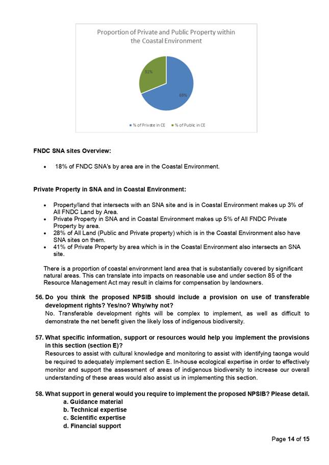
|
Strategy and Policy
Committee Meeting Agenda
|
30 July 2020
|
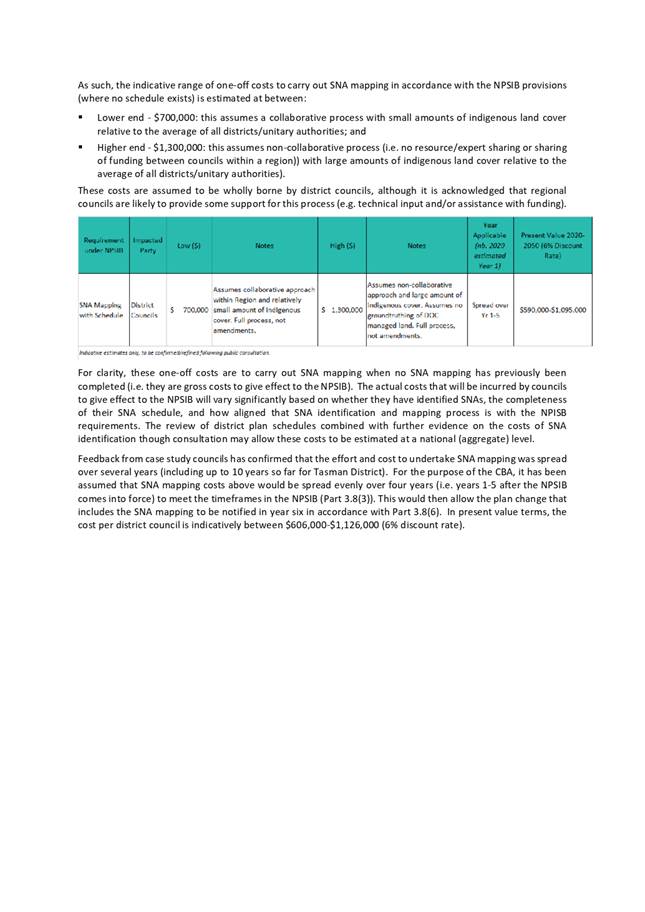
|
Strategy and Policy
Committee Meeting Agenda
|
30 July 2020
|
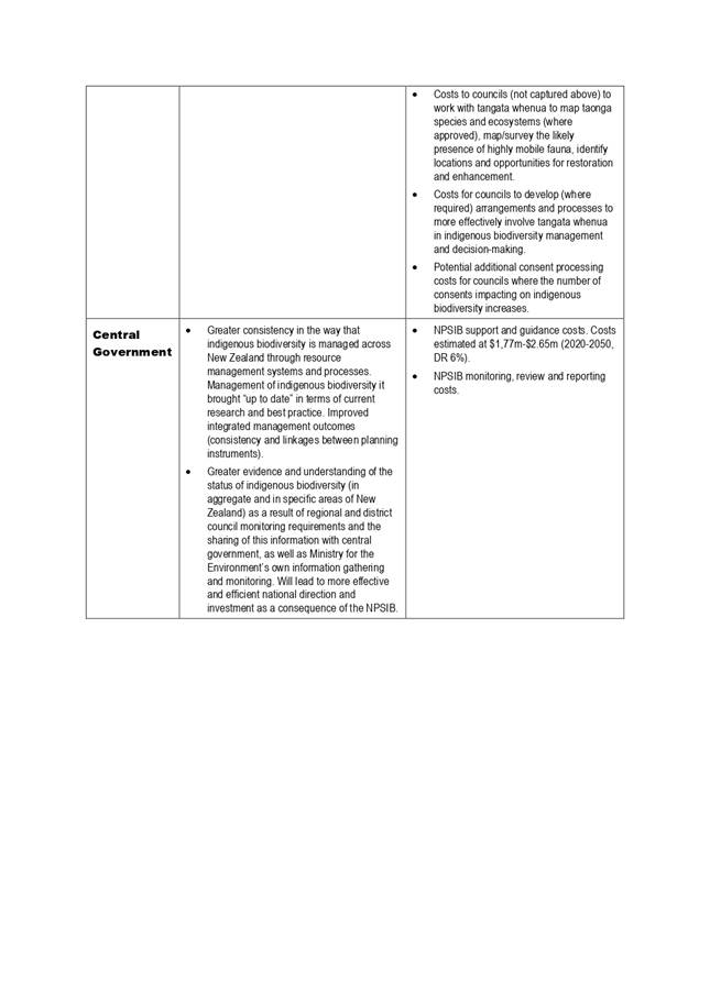
5.3 Future
Libraries Progress Report
File Number: A2912504
Author: Jacine
Warmington, Manager - Community and Customer Services
Authoriser: Dean Myburgh, General Manager - District Services
Purpose of the Report
To provide an
update about FNDC Libraries progress towards meeting Future Libraries strategic
outcomes.
Executive Summary
FNDC Libraries Future
Libraries strategy was signed off by council in 2018. Since then,
considerable work has been undertaken by the library team to achieve the
outcomes listed in the strategy.
This includes the
implementation of a new library management system, appointment of an outreach
librarian, increased digital literacy programming, new literacy programming for
under-2s, the beginnings of partnerships with external organizations and the
refresh of library spaces.
Key work still
remains to be done, including the implementation of customer self-service, and
the development of a literacy programme targeting areas of need in the Far
North. A dedicated programme to increase membership is also required.
However, Future
Libraries has a 10-year timeframe, and work is on track to achieve most
outcomes during this period.
|
Recommendation
That the Strategy and Policy Committee
receive the report “Future Libraries Progress Report”.
|
Background
Far
North District Libraries Future Libraries strategy was signed off by council
in December 2017 (refer Attachment 1). Since then, considerable work has been
undertaken by the library team to achieve outcomes listed in the strategy.
Discussion and Next Steps
Strategic
Outcomes
1. Completed
I. Library
Management System (LMS) upgrade
A project to upgrade the LMS from Horizon to Symphony was completed
in March, enabling Far North District Libraries to join the Kotui consortium of
39 other public libraries that use Symphony. The benefit will be to provide a
better customer experience, and to provide opportunities for shared services
with other public libraries, including Kaipara and Whangarei.
II. Library
outreach services
The Outreach Librarian commenced on 4 November 2019. The purpose of
this role is to provide library services outside the library walls, and access
to remote communities. This includes traditional mobile library book borrowing
services, but also information and digital literacy programming where there is
community need. So far, several visits to schools and organizations have been
completed, including VR movie making sessions with troubled teens at Kaitaia
College. In depth community engagement to help inform the service has been
completed through an online survey and by running a stall at Waitangi Day celebrations.
While FNDC have not yet secured a mobile van, the Outreach Librarian will begin
regular stops to the three wards in July.
III. Partnering
with external organizations
Partnerships have begun to form with a range of external
organizations. These include iwi groups with the Te Hononga building
Connections are also being made with local schools, including Kaitaia College,
Northland College, Kerikeri High School, Oromahoe Primary and Paihia school,
primarily to deliver digital and literacy services. Work is underway with
Auckland Museum, assessing the potential for display of artefacts at Williams
House in Paihia. Regular meetings are underway with Kaipara and Whangarei
Libraries, with a goal of future joined up services.
IV. Digital
programmes and services
Robot Tuesdays has been implemented as an after-school programme at
Procter Library. This programme provides attendees with STEAM construction
challenges, and a touch point for a range of robotic and coding resources.
Virtual Reality sessions have also been held in Kaitaia Library, Kaikohe
Library and in a number of schools. Access to the internet is being facilitated
through the Spark Jump programme in partnership with Digital Inclusion NZ, with
Kaitaia being a leading provider of this service across the country.
V. Staff
capability
A work stream has been developed to increase staff capability in key
areas that will help develop future library services. Two initial focus areas
are Te Reo Māori/Tikanga in partnership with local wananga, and Digital
skills.
VI. Programmes
and services
An increased range of public programming is beginning to be offered
across our library network. These include English Language sessions in
partnership with local language schools; technology help for seniors, with an
external provider; Tamariki Tune Time music and literacy sessions for
under-2’s and their whanau; Matariki; Lego club; Crafternoons; and an
increased range of author visits.
VII. Increased
online content
New online book and content databases have been implemented,
including BorrowBox (eBooks and eAudiobooks), Haynes Car Manuals, Mango
Languages and Bridget Williams Online Treaty of Waitangi Collection. Planning
has been done to incorporate a video streaming service for libraries and Press
Reader, which provides access to worldwide magazines and newspapers. Uptake of
both is under threat due to the effect of COVID-19 and drought on 20/21 budgets
VIII. New library
spaces
Te Hononga is on track for a September 2020 opening in Kawakawa.
Discussions around the proposed Te Pu o Te Wheke site in Kaikohe have stalled
as funding has been affected by COVID-19. Both sites would lead to significant
upgrades upon existing library buildings, and the opportunity to offer services
out of shared community locations.
IX. Library
fines
Library fines for children and teens were eliminated from July 1,
2020. This initiative will increase library access for young people, and lead
to an increase in the number of children and teens who are library members.
X. COVID-19
During the COVID-19 lockdown, an eLibrary team was developed to
support customer access to eBooks, library membership, social media activities
and library help. 8,352 eBooks were loaned by customers during the lockdown
period, an increase on previous years of over 90%. Social media reach
increased. Access to customer online help increased.
Library staff formed part of a team who regularly contacted Housing
for Elderly tenants across the Far North during lockdown and others volunteered
with external organisations such as Meals on Wheels and Te Runanga a Iwi o
Ngapuhi, supporting our communities.
XI. Collections refresh
Work has begun to
refresh library collections to improve customer access to books that meet their
needs. This includes a significant deselection exercise, to remove old and out
of date material; and targeted purchasing of new books, including an increased
range of te reo Māori content.
2. Future
work
Plans are underway to begin work in the
areas below in the next financial year:
I. Radio
Frequency Identification (RFID)
RFID is the implementation of technology to enable customer
self-service. It also facilitates a reduction of staff manual handling of
library books. This will enable a shift in the library service delivery model,
with increased focus on transformational community programming and services,
and less transactional work. It will also lead to a reduced risk of staff RSI
from book handling.
II. Capturing
the history of the Far North
Discussions have begun within FNDC about opportunities for council
to contribute to a platform that enables capture and dissemination of local
history, both in oral and visual form. No timeline has yet been set.
III. Increasing
support for literacy services
Although digital and ESL literacy programmes are in place, work
still needs to be done to increase the range of traditional literacy support
FNDC libraries are providing to families, schools and individuals.
IV. Online
content
Additional content is required to make library services more
accessible outside the library walls. This includes streaming sites for
libraries and Press Reader.
V. Procter
Library refresh
Planning will begin in the 20/21 financial year for an interior
refresh of Procter Library. This will include community input, with an aim of
ensuring the space is laid out and fitted out in a way that is best meeting
community need. This will include assessing the scope for a makerspace area and
an archival digitization space within this library
VI. Outsourcing
Collections
A procurement exercise is underway to secure a New Zealand company
to complete book cataloguing and processing for Far North District Libraries.
This work will enable the staff who are currently involved in this work to
become more heavily involved in initiatives that will improve the customer
experience with our collections. These include developing an enhanced Te Reo Māori
collection, implementing a floating collection to streamline book movement
between branches and working towards a regional service with other Northland
Libraries.
Financial Implications and
Budgetary Provision
No
financial implications.
Attachments
1. Far
North District Libraries Strategy - adopted December 2017 - A1956750 ⇩

|
Strategy and Policy Committee Meeting Agenda
|
30 July 2020
|

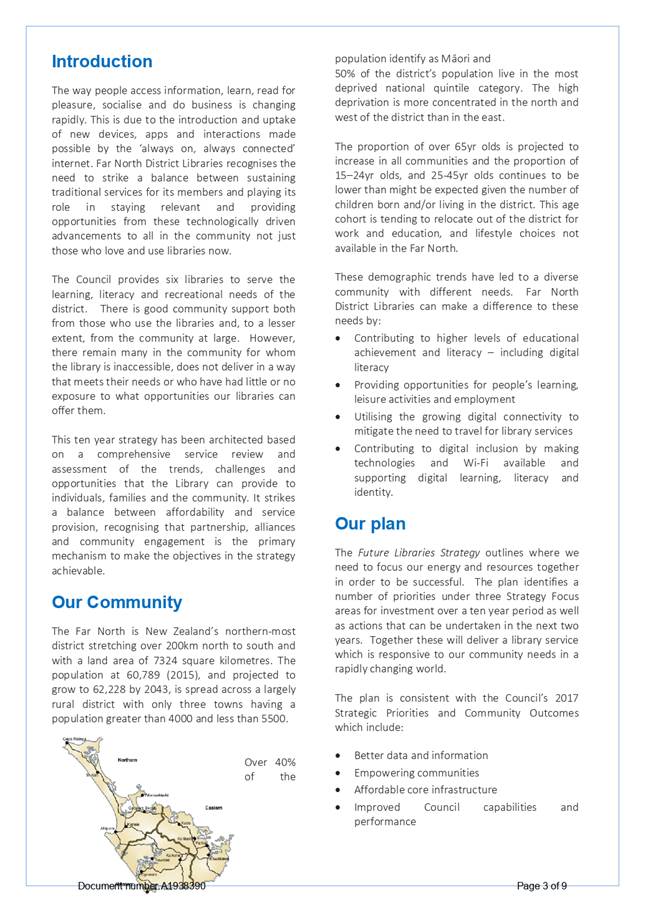


For the purpose of this report,
“Effectiveness”
means how successful a provision is in achieving the stated outcomes; and
“efficiency” means whether the benefits of the provision outweigh
the costs, either immediately, or over time.
[3] Section 1.1 Significant Resource Management Issues. Far North
District Plan. Chapter 1, Page 1.
). Guide for Users of the Threatened
Environment Classification, August 2007, Authors: Walker S, Cieraad E, Grove P,
Lloyd K, Myers S, Park T, Porteous T, for andcare Research New Zealand
Ltd.